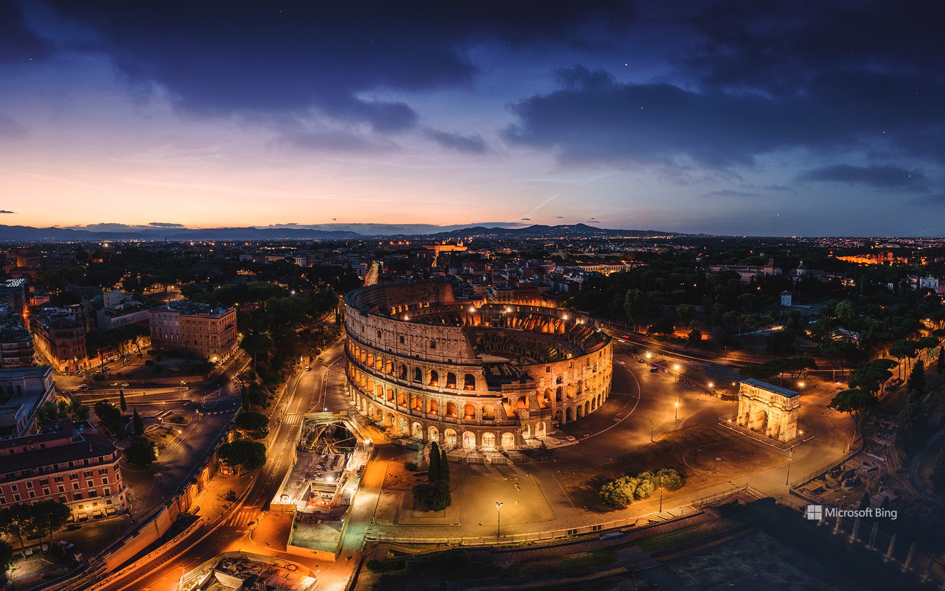
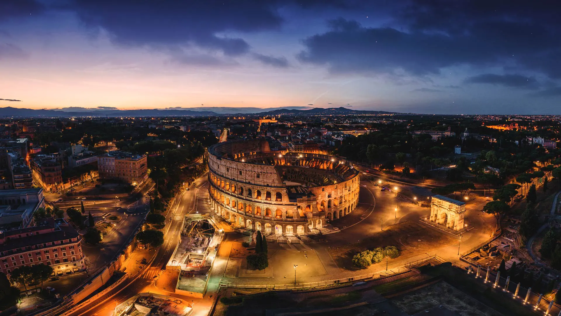
Tilting渔村, 福戈岛 , 纽芬兰和拉布拉多省, 加拿大 Fishing village of Tilting, Fogo Island, Newfoundland and Labrador, Canada (© FedevPhoto/Getty Images)

发布于 , 126 次浏览

Tilting渔村, 福戈 , 纽芬兰和拉布拉多省, 加拿大 Fishing village of Tilting, Fogo Island, Newfoundland and Labrador, Canada (© FedevPhoto/Getty Images)

原始渔村的风貌 Authentic Fishing Village Charm

Tilting渔村, 加拿大

蒂林村最初由18世纪的爱尔兰移民所建立,是极少数至今仍保留爱尔兰渔村文化特色的社区之一。当地渔棚与住宅采用明亮色彩,不仅具有装饰功能,更是为了在浓或风中提高可见性。这种设计体现了早期居民兼具实用性与创造力的生活智慧。今天,加拿大迎来了建国158周年纪念日。从东海岸的历史小村到现代都市,从多元文化融合到壮丽自然风,我们共同庆祝这个国家的历史积淀、文化底蕴与持续发展的未来愿景。

Happy Canada Day!

Today, Canada turns another year older. Canada Day is a nod to the moment when the country officially came together in 1867. What began as a confederation of Ontario, Quebec, New Brunswick, and Nova Scotia has grown into a nation of 10 provinces and 3 territories. Originally called Dominion Day, the name was changed to Canada Day in 1982—the same year the Constitution Act was signed, granting the country full control over its constitution. While Canada Day is not the country's 'Independence Day,' it's the closest thing to it. Canadians celebrate this holiday with fireworks, parades, concerts, and community events. Ottawa, the country's capital, hosts one of the biggest celebrations, featuring music and speeches on Parliament Hill.

On this day, it is hard to miss how the red and white houses in Tilting mirror the colors of the Canadian flag. Tilting, a village on Fogo Island in Newfoundland and Labrador, was settled by Irish immigrants in the 18th century. It remains a unique example of an Irish outport community that has preserved its cultural identity. The bright fishing sheds and homes weren't painted just for aesthetics; the hues make buildings easier to spot during heavy fog or snowfall. These vivid colors also reflect the practical, resourceful life of the people who settled here.

沃尔夫溪陨石坑, 澳大利亚 Wolfe Creek Crater, Australia (© Abstract Aerial Art/Getty Images)

发布于 , 19 次浏览

沃尔夫溪陨石坑, 澳大利亚 Wolfe Creek Crater, Australia (© Abstract Aerial Art/Getty Images)

是谁击中了地面? Rock-solid defense

小行星

地球表面每一道因陨石撞击而留下的伤痕,都讲述着一个关于宇宙的故事,从导致恐龙灭绝的小行星,到遍布全球却鲜为人知的陨石坑。小行星日正是为了提醒人类关注这些来自太空的访客,以及它们可能带来的潜在威胁。该纪念日设立于2015年,受到联合国支持,以纪念1908年6月30日发生在西伯利亚通古斯附近的通古斯大爆炸。这场爆炸摧毁了超过800平方英里的森林,所释放的能量相当于10至15兆吨TNT炸药。自那以后,科学家们通过研究亚利桑那州的巴林杰陨石坑、加拿大魁北克的马尼库阿甘陨石坑等地,深入探索了天体撞击对地球的影响。

如今日图片所示,位于澳大利亚西部的沃尔夫溪陨石坑,由一颗估计重达14000多吨的陨石撞击地面而形成。该陨石坑直径约为2,871英尺,坐落于偏远的沃尔夫溪陨石坑国家公园之中。园区内平坦的沙漠草原与干旱平原衬托出陨石坑边缘的醒目轮廓。如今,游客可沿着陨石坑边缘徒步,亲身体验这一宇宙撞击留下的印记,同时了解它在科学研究和澳大利亚原住民文化中所具有的重要意义。

Asteroid Day

Each scar on Earth from a meteorite impact tells a story—from the asteroid that wiped out the dinosaurs to the lesser-known craters that dot the planet. Asteroid Day highlights ongoing research into asteroids and the potential threats they pose. Started in 2015 and backed by the United Nations, this day marks the anniversary of the Tunguska event—a massive explosion that occurred in Siberia on June 30, 1908. This explosion flattened over 800 square miles of Siberian forest near the Tunguska River. The blast released energy equal to 10–15 megatons of TNT, a standard measure of explosive force. Since then, craters like Arizona's Barringer, Quebec's Manicouagan, and others have helped scientists study what happens when space rocks hit Earth.

Wolfe Creek Crater in Western Australia, pictured here, was created by a meteorite estimated to have weighed over 14,000 tons. The crater is about 2,871 feet in diameter and sits within Wolfe Creek Meteorite Crater National Park, a remote protected area. The park's flat plains and desert grasslands make the crater's rim especially visible. Today, visitors can walk along the rim and learn about its significance to both science and local Indigenous communities.

Pulau Ay蓝色泻湖, 班达群岛, 印度尼西亚 Blue lagoon of Pulau Ay, Banda Islands, Indonesia (© fabio lamanna/Alamy Stock Photo)

发布于 , 25 次浏览

Pulau Ay蓝色泻, 班达群岛, 印度尼西亚 Blue lagoon of Pulau Ay, Banda Islands, Indonesia (© fabio lamanna/Alamy Stock Photo)

哪里让历史变得“辛辣” Where history gets spicy

国际热带

每年6月29日是“国际热带日”,旨在引导人们关注紧贴赤道的热带地区,这些地区全年阳充足,却也在气候变化议题中尤为脆弱。热带带位于北回归线与南回归线之间,涵盖亚洲、非洲、大洋洲、中美洲及南美洲的部分地区。全球近40%的人口生活于此,这里同时孕育了全球约80%的生物多样性。不仅自然资源丰富、文化多元,这些地区也承载着重要的历史背景;然而它们也面临着气温上升、森林砍伐和快速城市化等挑战。

若你想了解一段“热”力十足的热带故事,不妨关注位于印度尼西亚班达群中的艾岛。如今日图片所示,肉豆蔻曾是全球最受欢迎的香料之一,而艾岛在全球肉豆蔻贸易中曾发挥关键作用。它曾引发全球列强之间的竞争与血腥的海上冲突,深刻影响了现代地缘政治格局。如今,艾岛的珊瑚礁依旧绚丽,豆蔻香仍扑鼻,历史则沉睡在苔藓覆满的古堡中。游客可在珊瑚花园中浮潜,在香料园中漫步,或在阳光下与当地人一同晾晒肉豆蔻外皮。因此,今天的意义不仅在于庆祝,更在于反思、学习与付诸行动。

International Day of the Tropics

Every June 29, the International Day of the Tropics shines a light on the equator-hugging zone where the sun sticks around, and climate conversations get real. The tropics span a broad region between the Tropic of Cancer and the Tropic of Capricorn, including parts of Asia, Africa, Oceania, Central America, and South America. Nearly 40% of the global population lives in this band, which also hosts 80% of the world's biodiversity. It's rich in culture, nature, and history—but also under pressure from rising temperatures, deforestation, and fast-paced urban growth.

For a tropical tale with extra flavor, look no further than Pulau Ay, photographed here. Nutmeg was once one of the world's most sought-after commodities—and this tiny island in Indonesia's Banda Islands played a key role in its global trade. It once sparked global rivalries and deadly sea battles, influencing the geopolitical boundaries of the modern world. Today, Pulau Ay is a place where reefs shine, nutmeg continues to thrive, and history lingers in moss-covered forts. Visitors can snorkel along coral gardens, wander through spice groves, or sit with locals drying mace under the sun. So, today's mission? Celebrate, sure—but also reflect, learn, and act.

曼海姆水塔, 德国 Mannheim Water Tower, Germany (© no limit pictures/Getty Images)

发布于 , 101 次浏览

曼海姆水塔, 德国 Mannheim Water Tower, Germany (© no limit pictures/Getty Images)

从实用建筑到地标象征 From functional building to landmark

曼海姆水塔, 德国

位于曼海姆市中心的这座水塔,正是今日图像中所展示的主体。它不仅仅是一座功能性建筑,更是曼海姆的文化象征。该塔由著名建筑师古斯塔夫·哈姆胡伯设计,他后来还参与了柏林国会大厦的建设。水塔建于1886至1889年之间,高达60米,最初作为城市饮用水的蓄水塔,储水容量可达200万升。如今,它不仅是一处旅游打卡地,也常用作文化活动与市民休闲的重要场所,象征着曼海姆在保留传统的同时拥抱现代化的城市精神。

然而,曼海姆的城市魅力远不止于此。这座城市因其独特的棋盘式街道布局而被誉为“方块城市”,并以创新精神著称。历史上,卡尔·本茨的第一辆汽车正是在曼海姆的街道上行驶,而世界上第一辆自行车也诞生于此。此外,曼海姆还是德国知名音乐团体“曼海姆之子”的发源地,为本地文化增添了独特韵律。探索曼海姆,便是走进一座将历史遗产与现代都市活力完美融合的城市典范。

Knuthöjdsmossen自然保护区, 海勒福什市, 瑞典 Knuthöjdsmossen nature reserve, Sweden (© Sven Halling/DEEPOL/plainpicture)

发布于 , 160 次浏览

Knuthöjdsmossen自然保护区, 海勒福什市, 瑞典 Knuthöjdsmossen nature reserve, Sweden (© Sven Halling/DEEPOL/plainpicture)

冰川遗迹之地 An ancient glacial landscape

Knuthöjdsmossen自然保护区, 瑞典

克努特霍德斯莫森自然保护区位于瑞典海勒福什市附近,占地近250英亩。这片宁静的绿洲拥有环形木栈道,穿越沼泽地带,沿途分布着多个小泊、沙丘湿地与松林。其中部分路段无障碍设计,适合轮椅和婴儿车通行。

该地区地貌约形成于一万年前,源自最后一次内陆川的融化过程,遗留下冰碛堆积物与冰川河流沉积沙层。保护区内最高的沙丘——斯托拉·哈勒福斯迪嫩,高达33英尺,是诸多稀有昆虫的重要栖息地,其中包括学名为Formica cinerea的灰蚁等极为稀见的物种。对于鸟类观察者而言,这里堪称天堂。你可以观测到包括红喉潜鸟、北方戴胜、青脚鹬与普通沙鸭在内的多样鸟种。区内主要种为松树,同时还生长着矮桦、乌鸦莓与野迷迭香等灌木植物。无论你是热衷生态探索的自然爱好者,还是渴望远离喧嚣的宁静旅行者,克努特霍德斯莫森自然保护区都将为你提供一处值得流连的目的地。

马头岩上空的银河, 新南威尔士州, 澳大利亚 The Milky Way over Horse Head Rock, New South Wales, Australia (© Philip Thurston/Getty Images)

发布于 , 243 次浏览

马头岩上空的银河, 新南威尔士州, 澳大利亚 The Milky Way over Horse Head Rock, New South Wales, Australia (© Philip Thurston/Getty Images)

海岸线附近的“马戏” Horsing around the coastline

马头岩,新南威尔士州,澳大利亚

人们常说:“你可以牵马到水边,却无法强迫它饮水。”当然,马头岩除外。这块岩石屹立于澳大利亚新南威尔士州伯马吉附近的蓝宝石海岸。如今日图片所示,这块古老的岩石宛如大自然亲手雕刻的一匹神话中的骏马,永远在低头畅饮海水。据估计,马头岩已有5亿年历史,其酷似一匹弯颈饮水的马,这正是风蚀与海浪侵蚀共同作用的结果。作为该地区最古老且最具象征意义的地质地标之一,马头岩全年吸引着徒步旅行者、摄影师与自然爱好者前来观赏。最佳观景点位于骆驼岩与穆鲁纳角之间的高地步道,而更富冒险精神的访客则可在退潮时,从骆驼岩冲浪海滩绕行至此。

伯马吉位于悉尼以南约240英里处,坐落于古拉加(又称单峰骆驼山)脚下。古拉加山是澳大利亚原住民尤因族的圣山,被尊称为“母亲山”。这一地区还拥有众多自然景观,包括骆驼岩、瓦拉加、伯马吉蓝池以及含羞草岩国家公园。此外,这里也是野生动物栖息和迁徙的重要区域,探索海岸线时,不妨留心观察正在迁徙的鱼、嬉戏的海豚与翱翔的海鹰。

Horse Head Rock, New South Wales, Australia

You can lead a horse to water, but you can't make it drink—unless, of course, you're talking about Horse Head Rock, perched off the Sapphire Coast near Bermagui in New South Wales, Australia. This ancient formation, pictured here, seems as if nature itself has sculpted a mythical creature forever poised to drink from the sea. Estimated to be 500 million years old, the rock's uncanny resemblance to a horse bending its neck is the result of wind and wave erosion. As one of the region's oldest and most iconic landmarks, it attracts hikers, photographers, and nature lovers year-round. The best views are from the elevated track between Camel Rock and Murunna Point, while the more daring can scramble around from Camel Rock Surf Beach, though only safely at low tide.

Bermagui, about 240 miles south of Sydney, sits under Gulaga, also known as Mount Dromedary. Gulaga is a sacred mountain for the Yuin peoples, an Australian Aboriginal group, who call it Mother Mountain. This area is also home to other highlights, like Camel Rock, Wallaga Lake, the Bermagui Blue Pool, or Mimosa Rocks National Park. Wildlife is abundant too—keep an eye out for migrating whales, playful dolphins, and soaring sea eagles as you explore the coastline.

格拉斯顿伯里托尔上的圣迈克尔塔, 格拉斯顿伯里, 萨默塞特郡, 英格兰 St. Michael's Church Tower on Glastonbury Tor, Glastonbury, Somerset, England (© Gavin Hellier/Getty Images)

发布于 , 31 次浏览

格拉斯顿伯里托尔上的圣迈克尔塔, 格拉斯顿伯里, 萨默塞特郡, 英格兰 St. Michael's Church Tower on Glastonbury Tor, Glastonbury, Somerset, England (© Gavin Hellier/Getty Images)

这里举办的是哪个音乐节? Tor and tunes: Glastonbury begins

格拉斯顿伯里音乐节开幕

当阳洒落在英格兰萨默塞特郡起伏的山丘上,格拉斯顿伯里音乐节便随之揭幕。这一音乐盛会最初的门票仅为1英镑,如今已发展为全球最具影响力的文化活动之一,每年吸引超过20万人参与。音乐节深植于嬉皮文化、20世纪60年代的反主流运动与自由音乐节的理念之中,这些价值观正是其诞生的基石。从大卫·鲍伊和艾尔顿·约翰,到金属乐队和比莉·艾利什,这个舞台承载了无数定义时代的经典演出。今年的格拉斯顿伯里音乐节从今天开始,持续至6月29日,主打阵容包括The 1975、尼尔·杨与奥利维亚·罗德里戈等。俯瞰整个音乐节现场的,是如今日图片所示的格拉斯顿伯里托尔丘。山顶耸立着14世纪的圣迈克尔教堂塔楼。托尔山被视为传说中亚瑟王的阿瓦隆王国所在地,并与古老的精神传统息息相关,成为历史与神话交汇之地。

如今,随着沃西农场大门开启,音乐回荡在广阔的田野之间,格拉斯顿伯里音乐节将再次展现其最具代表性的场景:将泥泞、旋律与奇迹融为一体,开启一段令人难忘的音乐冒险之旅。

Glastonbury Festival begins

As the sun rises over the hills in Somerset, Glastonbury Festival comes alive, transforming a quiet part of South West England into one of the world's most famous music destinations. Since its humble beginnings in 1970, when tickets cost just one British pound, Glastonbury has grown into a cultural powerhouse, attracting over 200,000 fans each year. The festival is deeply rooted in the ideals of the hippie movement, the 1960s counterculture, and the free festival spirit that sparked its early days. From David Bowie and Elton John to Metallica and Billie Eilish, Glastonbury's stages have hosted performances that have defined generations. This year's festival runs from today through June 29, with The 1975, Neil Young, and Olivia Rodrigo topping the bill. Overlooking the event is Glastonbury Tor, pictured here, a hill crowned by the 14th-century St. Michael's Church Tower. The Tor is steeped in myth and legend, from ties to King Arthur's Avalon to ancient spiritual lore.

精致拱门, 拱门国家公园, 犹他州, 美国 Delicate Arch, Arches National Park, Utah (© mmac72/Getty Images)

发布于 , 46 次浏览

精致拱门, 拱门国家公园, 犹他州, 美国 Delicate Arch, Arches National Park, Utah (© mmac72/Getty Images)

大自然的耐心之作 Nature took its time

精致拱门, 拱门国家公园, 犹他州, 美国

这片景观并非一朝一夕形成,而是大自然历经漫长岁月的雕琢之作。你在美国犹他州拱门国家公园所见的一切,是3亿多年间地壳抬升、风化与侵蚀共同作用的结果。这些天然拱门最初由古海洋遗留下的盐层构成,在时间推移中,砂岩层开裂、位移并不断风化,最终形成了超过2000座天然拱门。这些地貌主要由恩特拉达砂岩与纳瓦霍砂岩构成。该地区于1929年被认定为国家纪念地,并于1971年正式升格为国家公园。

其中最著名的拱门,便是今日图像所展示的精致拱门。它是美国西南部最具代表性的天然拱门之一。早期曾被称为“马裤”或“盐溪拱门”,直到1930年代,一次科学考察团队将其描述为“外观精致”,从而得名“精致拱门”。如今,精致拱门已成为犹他州的非官方象征,频繁出现在该州车牌、广告宣传,甚至印在1996年为纪念犹他建州百年而发行的美国邮票上。前往精致拱门需完成一段中等难度的徒步路线,途中需攀登滑岩面,贴近悬崖边缘前行。无论你是地质爱好者,还是寻求壮丽自然景观的旅行者,这座拱门都将为你带来难以忘怀的震撼体验。

Delicate Arch in Arches National Park, Utah

This landscape wasn't built overnight—nature took its time to craft it. What you see at Arches National Park in Utah, is the result of over 300 million years of erosion, uplift, and weathering. Over time, layers of sandstone cracked, shifted, and slowly wore away, revealing more than 2,000 natural arches. The formations are made mostly of Entrada and Navajo sandstone. The area was recognized as a national monument in 1929 and was upgraded to national park status in 1971.

The distinctive shape of Delicate Arch, seen here, has made it one of the most recognizable natural arches in the Southwest. Originally known by several other names—including the Chaps and Salt Wash Arch—it wasn't officially called Delicate Arch until the 1930s. It is Utah's unofficial mascot, appearing on everything from state license plates to a US postage stamp issued in 1996 to mark 100 years of Utah statehood. The arch is accessible via a moderately difficult hike that climbs over bare rock and skirts steep drop-offs. Whether you're a geology enthusiast or simply looking for a view worth the effort, Delicate Arch delivers.

德累斯顿易北河谷, 德国 Elbe river in Dresden, Germany (© Sean Pavone/Getty Images)

发布于 , 33 次浏览

德累斯顿易北河谷, 德国 Elbe river in Dresden, Germany (© Sean Pavone/Getty Images)

废墟中重生 From ruins to resilience

德累斯顿易北谷, 德国

柏林充满活力,慕尼黑以啤酒闻名,那么德累斯顿则诉说着历史与重生的故事。这座位于德国萨克森州的城市,曾被誉为“易北河上的佛罗伦萨”。然而,在1945年第二次世界大战期间,城市几乎被彻底摧毁。自那以后,它经历了浴火重生,如今成为一座融合现代艺术博物馆、巴洛克建筑与河畔风的文化城市。德累斯顿最古老的建筑群主要分布在老城区与新城区两大区域。周边街区最初由萨克森王室在18世纪至19世纪间规划,并以历代君主命名,例如腓特烈城和阿尔贝特城。

在老城区,可以漫步于宏伟的茨温格宫,这座宏伟的宫殿建筑群能一窥皇室历史,或前往森珀歌剧院,欣赏一场融合建筑艺术与歌剧表演的演出。对于艺术和历史爱好者而言,老大师画廊与绿色穹顶博物馆是不容错过的文化地标。而新城区则更具现代气息,街头艺术、独立设计店和精酿啤酒馆遍布其间,展现出城市的新活力。贯穿整座城市的是全长约724英里的易北河,它宽阔平缓,静静流淌,诉说着这座城市坚韧不屈的历史与重生之路。

The Elbe in Dresden, Germany

Berlin gets the buzz, Munich brings the beer, but what about Dresden, in eastern Germany? Dresden brings the story. The city, once called 'the Florence on the Elbe,' was nearly wiped off the map in 1945 during World War II. Since then, it has rebuilt itself into a place where modern museums, Baroque buildings, and riverside views share the same frame. Much of the city's oldest architecture can be found in the boroughs of Altstadt (Old Town) and Neustadt (New Town).

While you're here, consider strolling through Zwinger—a palatial complex—for a glimpse of royal history, or attending a performance at the Semperoper, where opera and architecture meet. The Old Masters Picture Gallery and the Green Vault are must-sees for art and history fans. The Elbe, stretching about 724 miles, flows through it all—wide, steady, and quietly powerful.

亚马逊雨林,厄瓜多尔 Amazon rainforest, Ecuador (© Mark Fox/Getty Images)

发布于 , 52 次浏览

亚马逊雨林厄瓜多尔 Amazon rainforest, Ecuador (© Mark Fox/Getty Images)

一路丛林 Jungle all the way

世界雨林日

“世界雨林日”不仅是日历上的一个纪念日,更是一项行动号召。该节日由非营利环保组织“雨林伙伴关系”于2017年设立,旨在提升公众对雨林重要性的认识,并推动全球范围内的保护工作。在美国,人们通过社区植、学校项目以及社交媒体活动参与纪念,宣传雨林保护的成功案例。许多植物园会举办特别展览,而环保组织则发起筹款挑战,以支持实地保护项目。

厄瓜多尔的亚马逊雨林是这片生态系统中最引人注目的区域之一。虽然面积不及巴西境内的雨林广阔,但它被认为是地球上生物多样性最密集的地区之一。这里栖息着丰富多样的生物种群,包括美洲虎、金刚鹦鹉、黑凯门鳄、电鳗以及众多尚未被科学命名的药用植物种类。这片雨林也是多个原住民群体的传统居住地,其中包括一些尚未与外界建立联系的部落,其领地依法受到保护。然而,这些社区的生活方式正面临日益严峻的威胁,尤其来自石油开采等工业活动的影响。“世界雨林日”提醒我们:保护雨林并非遥不可及的目标。通过个人选择与集体行动,从减少纸张使用到支持可持续产品,公众的努力可以在厄瓜多尔的亚马逊雨林,乃至更广阔的热带雨林地区,产生实质影响。

World Rainforest Day

World Rainforest Day is not just a calendar event—it's a call to action. Established in 2017 by Rainforest Partnership—a nonprofit environmental organization—the day raises awareness about the importance of rainforests and mobilizes efforts to protect them. In the US, the occasion is marked with community tree plantings, school projects, and social media campaigns that highlight conservation successes. Many botanical gardens host special exhibits, while environmental groups run fundraising challenges to support on-the-ground protection efforts.

One notable region of the Amazon rainforest is in Ecuador. Although smaller than Brazil's share, it's considered one of the most biologically dense areas on Earth. It also shelters an extraordinary range of life—jaguars, macaws, black caimans, electric eels, and medicinal plants, many still unknown to science. This part of the rainforest is home to Indigenous groups, including uncontacted tribes whose territories are legally protected. But their way of life is increasingly threatened by industrial activities, especially oil drilling. World Rainforest Day reminds us that the protection of rainforests is possible through personal choices and collective action. From reducing paper use to supporting rainforest-friendly products, people can make tangible impacts that reach Ecuador's Amazon and beyond.

热门文章

归档