标签 美国 下的文章
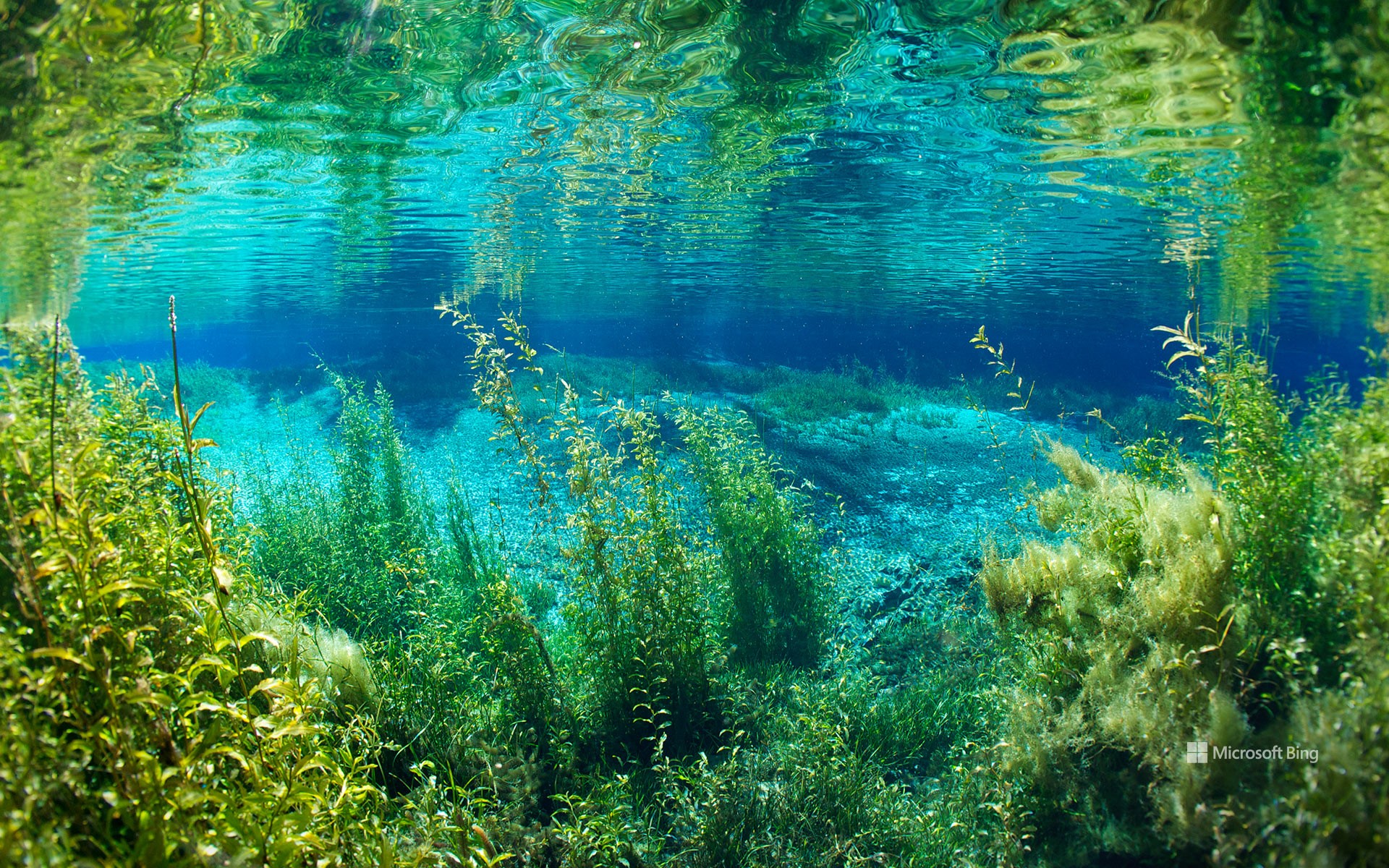
彩虹泉州立公园的彩虹河,佛罗里达州,美国 Rainbow River in Rainbow Springs State Park, Florida (© Michel Roggo/Minden Pictures)
彩虹泉州立公园的彩虹河,佛罗里达州,美国 Rainbow River in Rainbow Springs State Park, Florida (© Michel Roggo/Minden Pictures)
彩虹河的清澈拥抱 The clear embrace of Rainbow River
彩虹泉州立公园的彩虹河,佛罗里达州,美国
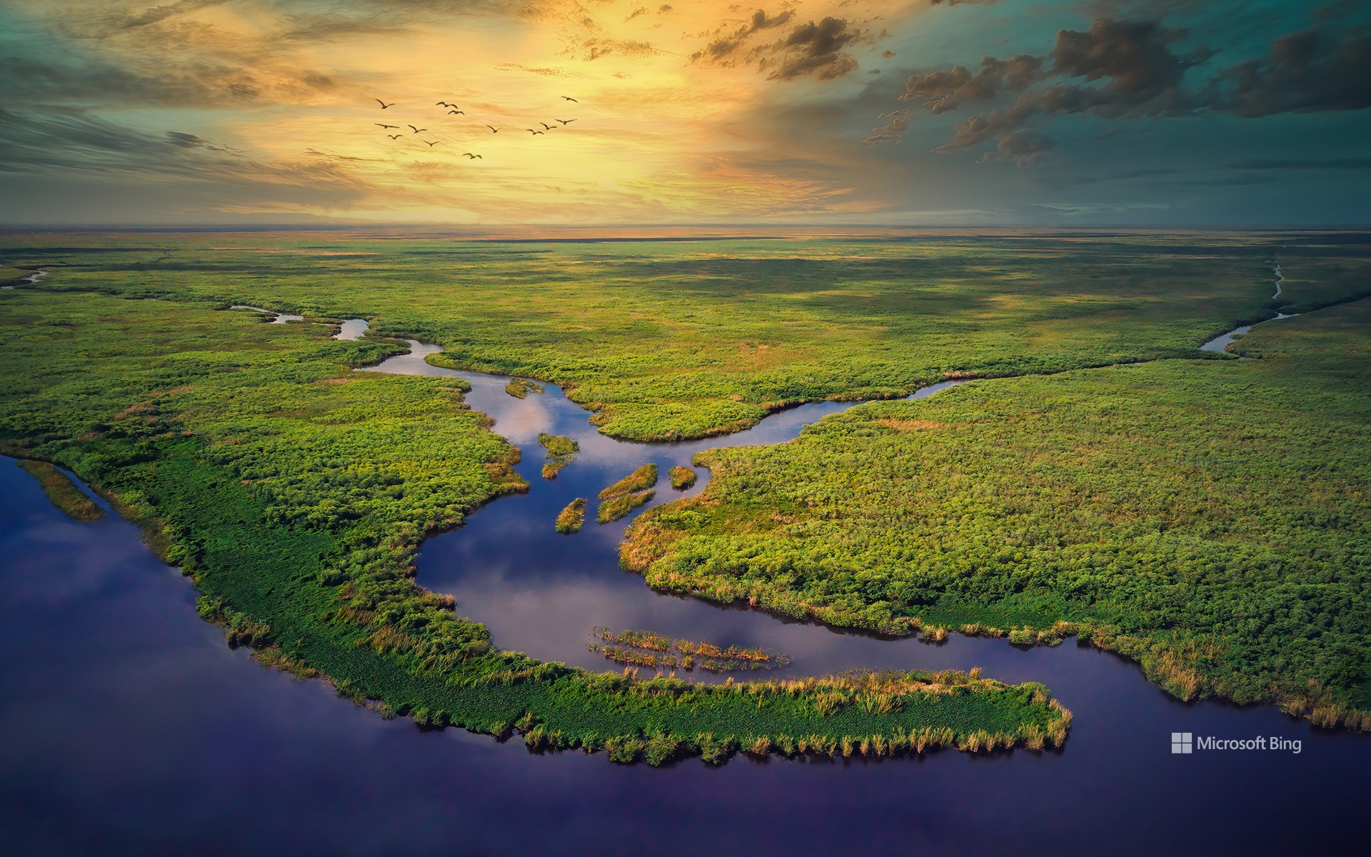
坐落于佛罗里达州北部墨西哥湾沿岸的,是彩虹泉州立公园。数百年来,这片区域一直作为自然资源,为人类与动物所依赖。穿越公园蜿蜒流淌的彩虹河,正是其中的关键生态要素。河水源自佛罗里达州最大型的泉水之一彩虹泉,其水体汇集自770平方英里的广阔集水区,最终流入威特拉库奇河。
彩虹河清澈见底,全年水温恒定在72华氏度,非常适合游泳与浮潜。公园的历史可以追溯到19世纪80年代末,当时在该地区发现了硬岩磷矿,掀起了一场短暂而热烈的繁荣时期。受磷矿开采推动,一个名为朱丽叶的小型社区迅速在泉水周边发展起来。进入20世纪60年代,该地区逐渐转型为旅游胜地,推出了玻璃底船、单轨列车系统,甚至还有马术表演等游客娱乐项目。如今,游客可以探访这里的观赏花园、瀑布和步道,并近距离观察栖息于此的丰富野生动植物群落,感受这片水域的魅力。
Rainbow River, Rainbow Springs State Park, Florida
Nestled in the northern Gulf Coast of Florida, is Rainbow Springs State Park. This area has served as a natural resource for humans and animals for centuries, with the Rainbow River—flowing through the park—playing a major role. The gently winding waterway is fed by Rainbow Springs, one of Florida's largest springs. The water that bubbles up here comes from a 770-square-mile area and eventually flows into the Withlacoochee River.
The Rainbow River's transparent waters are perfect for swimming and snorkeling, and they maintain a constant temperature of 72°F year-round. The park's history dates to the late 1880s, when hard rock phosphate was discovered in the area, leading to a boomtown era. This period saw the rapid growth of a small community called Juliette near the springs, driven by the phosphate mining industry. During the 1960s, the park emerged as a popular tourist destination, featuring glass-bottom boat rides, a monorail system, and even a rodeo. Today, visitors can explore the ornamental gardens, waterfalls, and walking paths, and enjoy the diverse wildlife that calls Rainbow Springs home.
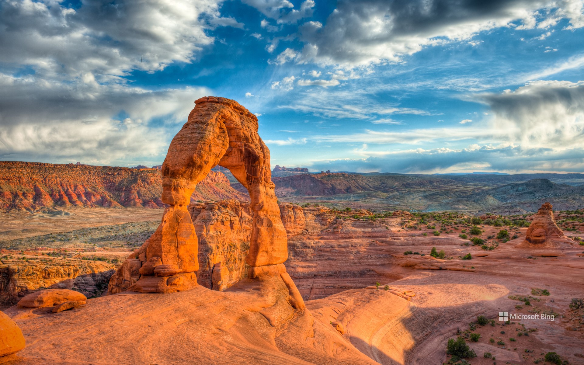
精致拱门, 拱门国家公园, 犹他州, 美国 Delicate Arch, Arches National Park, Utah (© mmac72/Getty Images)
精致拱门, 拱门国家公园, 犹他州, 美国 Delicate Arch, Arches National Park, Utah (© mmac72/Getty Images)
大自然的耐心之作 Nature took its time
精致拱门, 拱门国家公园, 犹他州, 美国
这片景观并非一朝一夕形成,而是大自然历经漫长岁月的雕琢之作。你在美国犹他州拱门国家公园所见的一切,是3亿多年间地壳抬升、风化与侵蚀共同作用的结果。这些天然拱门最初由古海洋遗留下的盐层构成,在时间推移中,砂岩层开裂、位移并不断风化,最终形成了超过2000座天然拱门。这些地貌主要由恩特拉达砂岩与纳瓦霍砂岩构成。该地区于1929年被认定为国家纪念地,并于1971年正式升格为国家公园。
其中最著名的拱门,便是今日图像所展示的精致拱门。它是美国西南部最具代表性的天然拱门之一。早期曾被称为“马裤”或“盐溪拱门”,直到1930年代,一次科学考察团队将其描述为“外观精致”,从而得名“精致拱门”。如今,精致拱门已成为犹他州的非官方象征,频繁出现在该州车牌、广告宣传,甚至印在1996年为纪念犹他建州百年而发行的美国邮票上。前往精致拱门需完成一段中等难度的徒步路线,途中需攀登光滑岩面,贴近悬崖边缘前行。无论你是地质爱好者,还是寻求壮丽自然景观的旅行者,这座拱门都将为你带来难以忘怀的震撼体验。
Delicate Arch in Arches National Park, Utah
This landscape wasn't built overnight—nature took its time to craft it. What you see at Arches National Park in Utah, is the result of over 300 million years of erosion, uplift, and weathering. Over time, layers of sandstone cracked, shifted, and slowly wore away, revealing more than 2,000 natural arches. The formations are made mostly of Entrada and Navajo sandstone. The area was recognized as a national monument in 1929 and was upgraded to national park status in 1971.
The distinctive shape of Delicate Arch, seen here, has made it one of the most recognizable natural arches in the Southwest. Originally known by several other names—including the Chaps and Salt Wash Arch—it wasn't officially called Delicate Arch until the 1930s. It is Utah's unofficial mascot, appearing on everything from state license plates to a US postage stamp issued in 1996 to mark 100 years of Utah statehood. The arch is accessible via a moderately difficult hike that climbs over bare rock and skirts steep drop-offs. Whether you're a geology enthusiast or simply looking for a view worth the effort, Delicate Arch delivers.
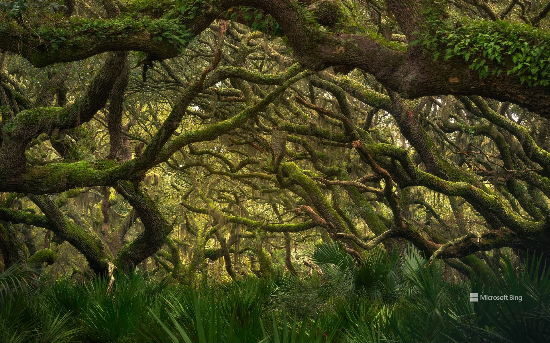
坎伯兰岛国家海岸的海滨森林,乔治亚州,美国 Maritime forest in Cumberland Island National Seashore, Georgia (© Chris Moore/TANDEM Stills + Motion)
坎伯兰岛国家海岸的海滨森林,乔治亚州,美国 Maritime forest in Cumberland Island National Seashore, Georgia (© Chris Moore/TANDEM Stills + Motion)
海岸静谧,野性依旧 Coastal quiet, untamed life
坎伯兰岛国家海岸的海滨森林,乔治亚州,美国
在你踏上沙滩之前,便能听见海风中树叶的沙沙声、扭曲树干的嘎吱响,以及仿佛来自古老世界的低语。欢迎来到乔治亚州大西洋海岸最南端坎伯兰岛国家海岸的海滨森林。面对盐雾、沙土与飓风的挑战,这里的树木依旧坚定屹立。南方红橡树弯而不折,锯叶棕榈如同绿叶护卫般贴地而生,西班牙苔藓则似大自然的流苏垂挂于树枝之上。这片海洋森林是美国现存最完整的此类稀有生态系统之一。得益于坎伯兰岛被划定为国家海岸,其生态得以避免其他海岸地区常见的城市化侵蚀。
你眼前所见的,正是数百年来始终如一的森林景貌,仅留下苏格兰裔美籍工业家托马斯·卡内基当年的遗迹,以及偶尔穿行林间的野马。这些马匹是早期定居者留下的家畜后代,如今已成为岛上的“非官方吉祥物”。 除了野马之外,这片森林中还栖息着丰富的野生动物,例如在灌木丛中挖掘的犰狳、在树干上啄击的啄木鸟,以及在林下活动的浣熊。沿着南端步道或平行步道等小径穿行于茂密的植被之中,行进途中不时可见沼泽地貌或隐藏的历史遗迹。所以,下次当你想到海岸时,请记住:真正的故事未必发生在海浪边,有时,它就深藏在沙丘之后。
Maritime forest in Cumberland Island National Seashore, Georgia
Before you hit the beach, you'll hear it—the rustle of leaves in salty air, the creak of twisted trunks, the hush of an old world. Welcome to the maritime forest of Cumberland Island National Seashore on the southernmost stretch of Georgia's Atlantic coast. Salt spray, sandy soil, hurricanes? The trees here stand their ground. Live oaks bend but don't break. Saw palmettos crowd the ground like leafy bodyguards, while Spanish moss hangs from branches like nature's fringe. This maritime forest is one of the best remaining examples of this rare habitat in the United States. Thanks to its national seashore status, the island has been spared from the concrete creep seen on other coastlines.
What you see here is the forest as it's been for centuries—a few ruins from the days of Scottish American industrialist Thomas Carnegie and the occasional feral horses grazing through. The horses are descendants of animals left by settlers long gone, and they're now unofficial mascots of the area. Alongside them, you might spot armadillos digging through the undergrowth, woodpeckers hammering tree trunks, or raccoons engaging in tiny heists. Trails like the South End Trail or the Parallel Trail weave through dense foliage, sometimes giving glimpses of marshes or hidden historic sites. So next time you think of the coast, remember: the real drama isn't always on the shore. Sometimes, it's rooted just beyond the dunes.
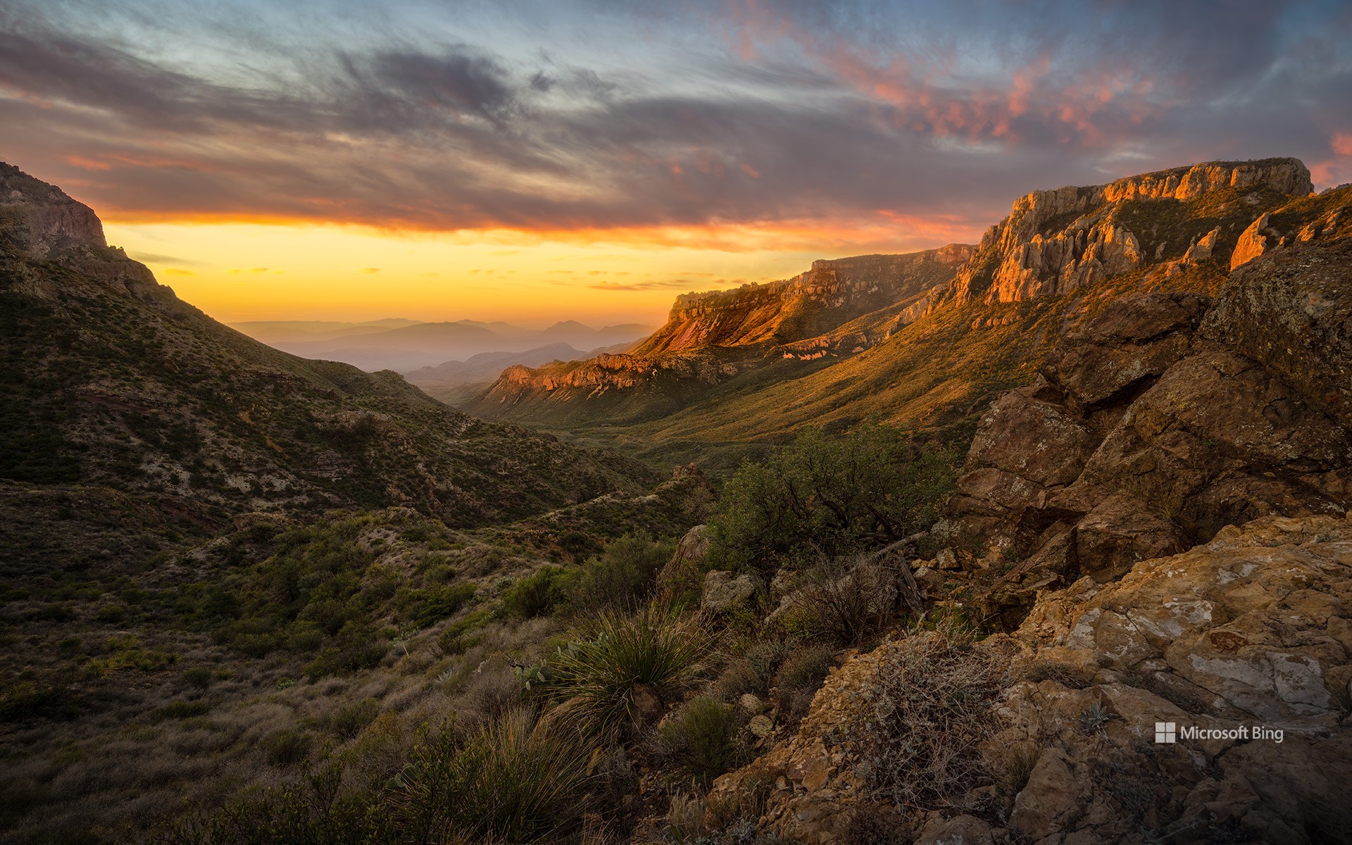
奇索斯山脉,大弯国家公园,德克萨斯州,美国 Chisos Mountains, Big Bend National Park, Texas (© Dean Fikar/Getty Images)
奇索斯山脉,大弯国家公园,德克萨斯州,美国 Chisos Mountains, Big Bend National Park, Texas (© Dean Fikar/Getty Images)
星空、岩石与孤寂 Stars, stone, and solitude
大弯国家公园迎来81周年
人们常说:“德州的一切都更大。”而大弯国家公园正是对这句话的最佳注解。这片占地801,163英亩的广袤区域,最初属于墨西哥领土,1848年并入美国。自20世纪30年代起,该地区的自然景观便受到保护,并于1944年6月12日正式被指定为国家公园。大弯国家公园是美国最偏远、游客最少的国家公园之一。它并非由单一地貌构成,而是三种景观的综合体:奇瓦瓦沙漠、奇索斯山脉和格兰德河。公园地处美墨边境,其历史也体现出文化交融的特征:原住民、西班牙探险者、牧场主、矿工和游客皆曾在此留下足迹。岩画、历史遗迹和古道见证了这片土地在成为国家公园之前就已拥有深厚历史。
公园内生物多样性极为丰富,记录有超过1,200种植物、超过450种鸟类,以及多种哺乳动物、爬行动物和两栖动物。你可能会看到一只走鹃迅速穿越沙尘,或是一只山猫悄然穿行于灌木之间。此外,大弯国家公园也被评为美国最佳暗夜公园之一。游客在此可观赏到银河、行星和满天繁星构成的璀璨星空。
Big Bend National Park in Texas turns 81
They say everything's bigger in Texas—and Big Bend National Park has been living up to the slogan since forever. Efforts to preserve this 801,163-acre area of West Texas began in the 1930s and culminated in its official designation as a park on June 12, 1944. Big Bend remains one of the most remote and least-visited national parks in the country. It's not just one landscape, it's three: the Chihuahuan Desert, the Chisos Mountains (pictured here), and the Rio Grande. Big Bend sits on the US–Mexico border, and its history reflects that blend. Indigenous peoples, Spanish explorers, ranchers, miners, and modern travelers have all left their footprints. Petroglyphs, ruins, and old trails show the land's story began long before it became a park.
The park is home to over 1,200 species of plants, more than 450 species of birds, and a wide variety of mammals, reptiles, and amphibians. You might spot a roadrunner zipping across the dirt, or a bobcat silently slipping through the underbrush. Additionally, it has been designated as one of the best dark-sky parks in America, offering views of the Milky Way, planets, and constellations.
大沼泽地国家公园的鸟瞰图,佛罗里达州,美国 Aerial view of Everglades National Park, Florida (© Robert DelVecchio - OcuDrone/Getty Images)
大沼泽地国家公园的鸟瞰图,佛罗里达州,美国 Aerial view of Everglades National Park, Florida (© Robert DelVecchio - OcuDrone/Getty Images)
草之河流 A river of grass
大沼泽地国家公园,佛罗里达州
我们是否曾设想,从高空俯瞰自身在这片广袤水域中的倒影?佛罗里达州的大沼泽地国家公园是美国最大的热带荒野,面积超过150万英亩。它保护了原始大沼泽地的南部20%,栖息着众多珍稀和濒危物种,包括佛罗里达美洲豹、美洲鳄以及西印度海牛。大沼泽地国家公园被称为“草之河”,其独特的生态系统由从奥基乔比湖缓慢流向佛罗里达湾的河流供养,是热带涉禽的重要繁殖地。这座国家公园不仅是美国的自然瑰宝,也具有重要的国际价值。它被联合国教科文组织列为世界遗产、国际生物圈保护区以及国际重要湿地。
大沼泽地公园在水资源保护与防洪调蓄方面也发挥着至关重要的作用,其湿地系统如同天然过滤器,同时也是抵御风暴侵袭的重要缓冲区。当前,针对大沼泽地的保护与生态修复工作仍在持续推进,涵盖多个方面,包括应对入侵物种、改善水质及保护野生动物栖息地等关键举措。
Everglades National Park, Florida
Wouldn't it be great to see our reflection from above in this vast expanse of water? Everglades National Park, located in Florida, is the largest tropical wilderness in the US, spanning more than 1.5 million acres. It protects the southern 20% of the original Everglades and is home to numerous rare and endangered species, including the Florida panther, American crocodile, and West Indian manatee. Often referred to as the 'River of Grass,' the park's unique ecosystem, fed by a slow-moving river from Lake Okeechobee to Florida Bay, is a significant breeding ground for tropical wading birds. Everglades National Park is not only a national treasure but also an international one, recognized as a World Heritage Site, an International Biosphere Reserve, and a Wetland of International Importance.
The park also plays a crucial role in water conservation and flood control, as its wetlands serve as natural filters and buffers against storms. Efforts to preserve and restore the Everglades are ongoing, with numerous initiatives aimed at combating invasive species, improving water quality, and protecting wildlife habitats.
松山顶峰, 洛杉矶国家森林公园, 加利福尼亚州, 美国 Summit of Pine Mountain, Angeles National Forest, California (© Matthew Kuhns/TANDEM Stills + Motion)
松山顶峰, 洛杉矶国家森林公园, 加利福尼亚州, 美国 Summit of Pine Mountain, Angeles National Forest, California (© Matthew Kuhns/TANDEM Stills + Motion)
走上高远之路 Taking the high road
松山顶峰, 洛杉矶国家森林公园
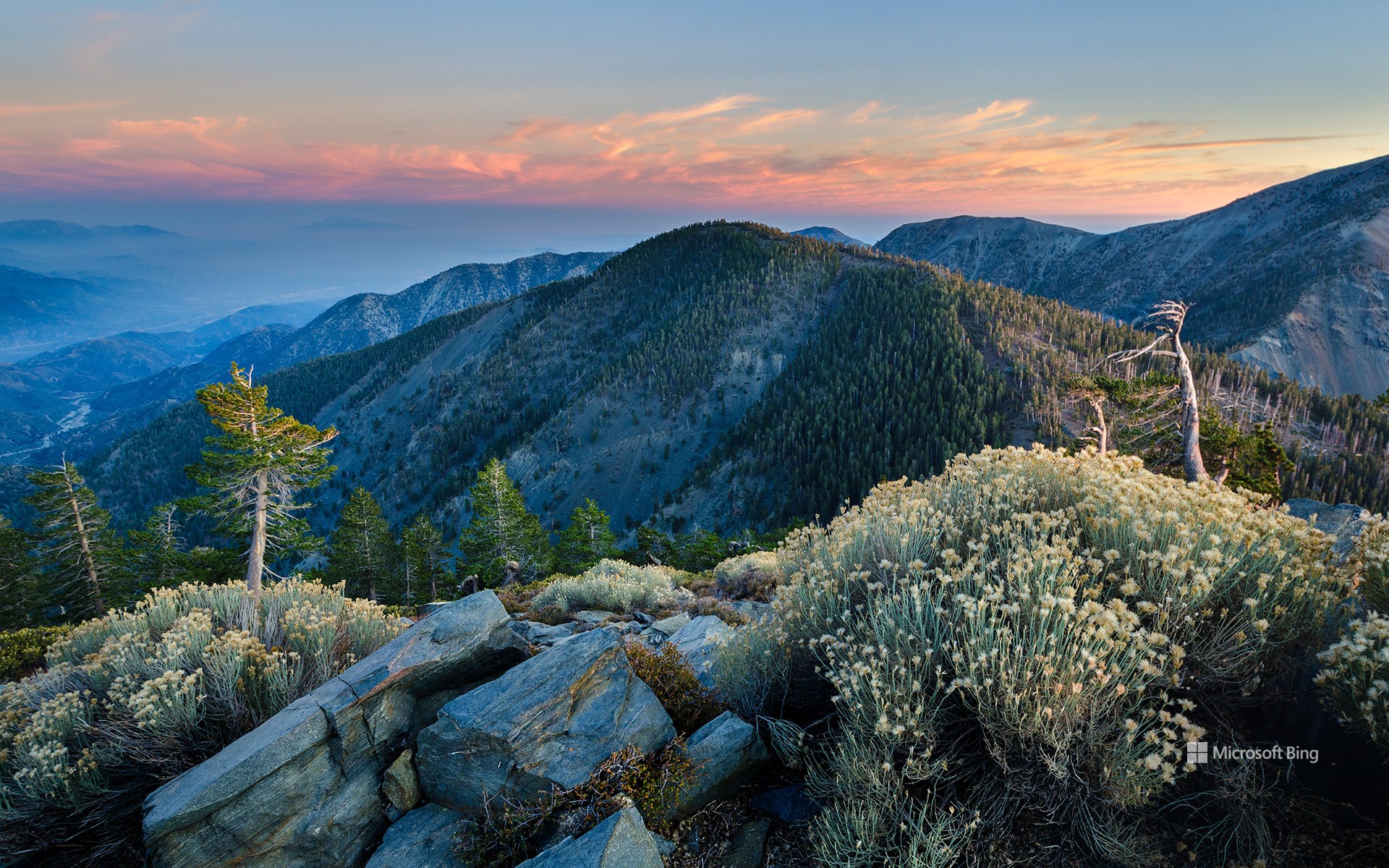
森林步道不仅仅是一条欣赏大自然的路径,它们将人们与自然和冒险联系在一起。如今日图片所示的是位于加利福尼亚州的洛杉矶国家森林的步道。此地拥有高耸的松树、崎岖的山脊,并包含著名的太平洋山脊步道(PCT)的一段。该步道全长超过2600英里,从墨西哥延伸至加拿大,是许多徒步爱好者心中的终极梦想。太平洋山脊步道于1968年被指定为国家风景步道,穿越7座国家公园和25个国家森林,是领略美国西部壮丽风光的独特方式。不过,想要体验它的魅力,并不需要走完全程。在加州南部,该步道穿越圣盖博山脉的部分便可带来壮观景色和充满成就感的一日徒步体验。
National Trails Day
Today, we celebrate the paths that connect us with nature and adventure. Angeles National Forest in Southern California is home to towering pines and rugged ridgelines, and hosts a stretch of the legendary Pacific Crest Trail (PCT). Winding over about 2,650 miles from Mexico to Canada, the PCT is the ultimate thru-hiking dream. Designated a National Scenic Trail in 1968, it traverses seven national parks, 25 national forests, and provides a unique lens through which to experience the dramatic landscapes of the American West. But you don't need to go the distance to enjoy its magic. In Southern California, portions of the trail through the San Gabriel Mountains offer great views and rewarding day hikes.
This year, National Trails Day isn't just about adventure, it's also about stewardship. These trails need our love and care to stay wild and walkable. So, bring a trash bag, join a cleanup drive, or just spread the word about keeping trails pristine and thriving for generations to come.
小鸽子河,大雾山国家公园,田纳西州, 美国 Little Pigeon River, Great Smoky Mountains National Park, Tennessee (© GreenStock/Getty Images)
小鸽子河,大雾山国家公园,田纳西州, 美国 Little Pigeon River, Great Smoky Mountains National Park, Tennessee (© GreenStock/Getty Images)
流经烟雾弥漫之地 Flowing through the Smokies
小鸽子河,大雾山国家公园,田纳西州
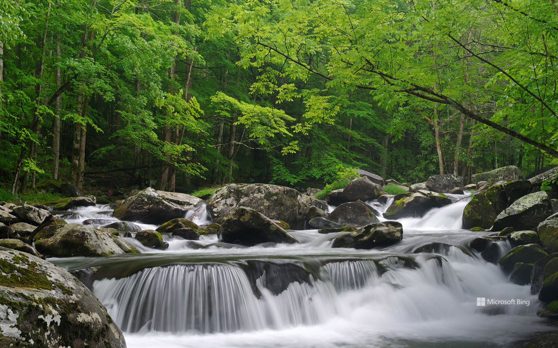
若不留神,便可能错过它,直到耳边传来潺潺水声、鳟鱼跃水的扑通声,或远处徒步者的欢笑声。这便是小鸽子河,蜿蜒穿越美国田纳西州的大烟山国家公园。在漂流活动与飞蝇钓兴起之前,这条河曾是当地原住民与早期定居者赖以生存的重要资源。切罗基族曾在此捕鱼,定居者沿河建起磨坊,盖特林堡、鸽子谷等城镇亦因河而兴。河名“小鸽子”源于曾栖息于此的旅鸽,尽管这一物种已于20世纪初灭绝,这一命名仍是对自然历史的纪念。
小鸽子河由西、中、东三支流汇聚而成,流经大烟山腹地,最终注入鸽子河沿河分布着诸多徒步路线,如盖特林堡步道,为游客提供平缓的路径、清澈的河景与舒适的树荫休憩点。部分路线,如拉姆齐瀑布小径,则沿河深入国家公园内部,并以壮丽瀑布作为终点。黑熊、蝾螈、翠鸟,甚至偶尔出现的水獭,都以小鸽子河为水源栖息地。下次造访大烟山国家公园时,不妨在仰望群山之余,也驻足低头欣赏脚下这条静静流淌、充满生命的河流。
Little Pigeon River, Great Smoky Mountains, Tennessee
You'll hear it before you see it. The steady ripple, the splash of trout, the distant laughter of hikers. That's the Little Pigeon River, threading its way through Great Smoky Mountains National Park in Tennessee. Long before tourists tubed it and fly fishers angled in it, this river was how people stayed afloat. The Cherokee tribe fished in it. Settlers built grist mills along it. Towns like Gatlinburg and Pigeon Forge grew up next to it. Even the river's name is a nod to the past—the passenger pigeon, once common in the area, vanished by the early 1900s.
The West, Middle, and East Prongs of the Little Pigeon come together to form a system that cuts through the Smokies and flows into the Pigeon River. Trails like the Gatlinburg Trail run alongside the river, offering flat paths with water views and shady rest spots. Some hikes, like the Ramsey Cascades trail, follow the river deeper into the park and reward you with impressive waterfalls. Black bears, salamanders, kingfishers, and the occasional river otter treat the Little Pigeon like their favorite watering hole. So, next time you're in the Smokies, don't just look up at the peaks, listen to the water below.
汉密尔顿山, 旧金山湾区, 加利福尼亚, 美国 Mount Hamilton, San Francisco Bay Area, California (© Jeffrey Lewis/TANDEM Stills + Motion)
汉密尔顿山, 旧金山湾区, 加利福尼亚, 美国 Mount Hamilton, San Francisco Bay Area, California (© Jeffrey Lewis/TANDEM Stills + Motion)
汉密尔顿山的蜿蜒之路 Twists and turns of Mount Hamilton
汉密尔顿山, 旧金山湾区, 加利福尼亚
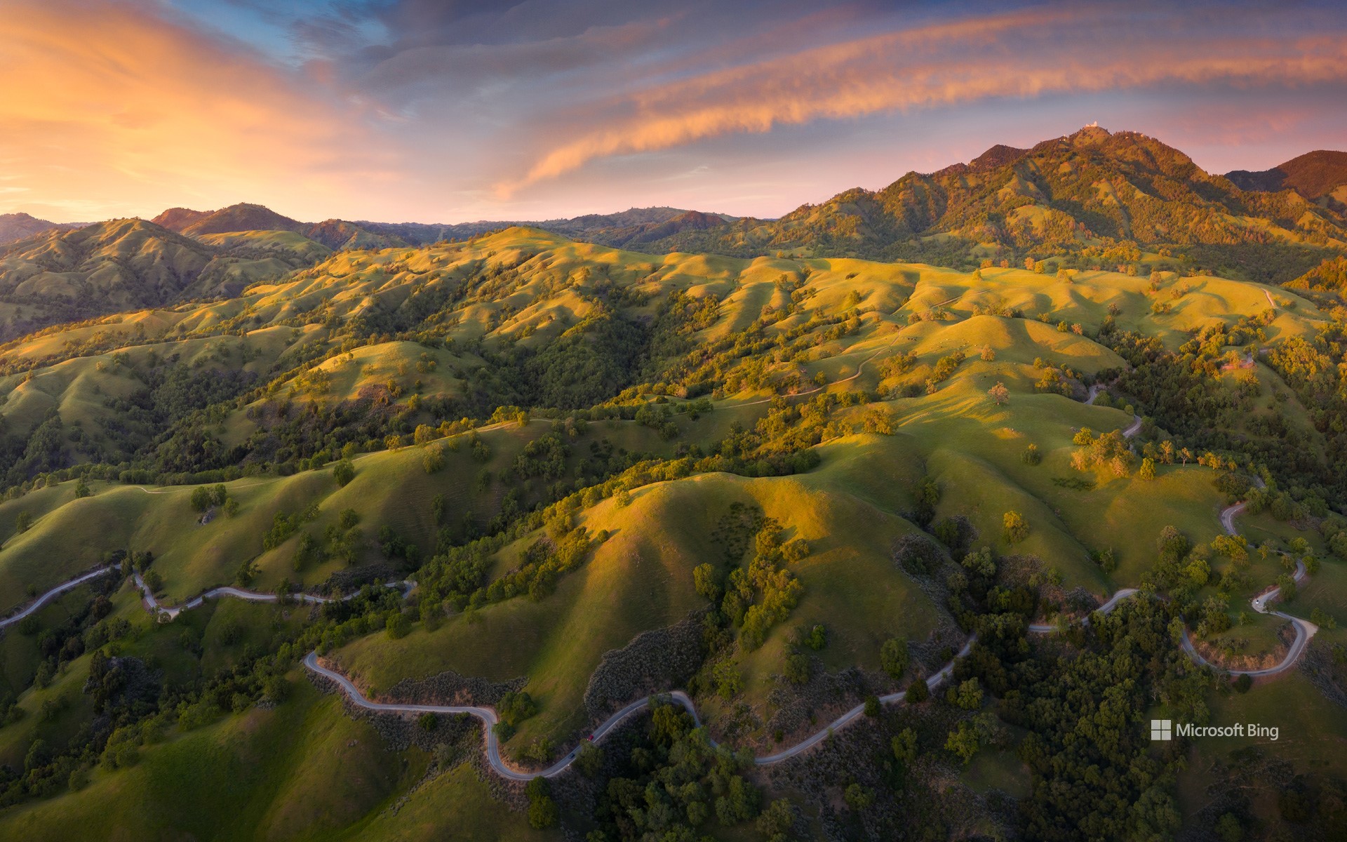
驾车驶上加州湾区的汉密尔顿山,游客将沉浸于迷人的自然景观与丰富的历史之中。全长19英里的汉密尔顿山公路,是130号州道的一部分。凭借漫长的爬坡路段和稀少的车流量,该道路深受骑行与摩托车爱好者的喜爱。这条公路建于1875年至1876年,最初旨在为世界首个长期有人驻守的山顶天文台“利克天文台”运送建材而修建。在海拔4265英尺的山顶,天气晴朗时,甚至可以远望至优胜美地国家公园或内华达山脉。
该地区拥有一些特有的珍稀物种,例如汉密尔顿宝石花和图莱麋鹿。在山坡地带,还可能发现金雕的筑巢地。无论是因道路的蜿蜒曲折而吸引,还是为欣赏沿途美景而前往,汉密尔顿山都能使人感受到与自然环境之间的紧密联系。
Mount Hamilton, near San Jose, California
Drive up Mount Hamilton just east of San Jose, California, and immerse yourself in stunning views and rich history. The 19-mile Mount Hamilton Road is loved by cyclists and motorcyclists for its long climbs and sparse traffic. Built in 1875-76, the road was designed to transport materials to the Lick Observatory, the world's first permanently occupied mountaintop observatory. On a clear day, you can see as far as Yosemite National Park or the Sierra Nevada from the 4,265-foot summit.
Several rare species are endemic to this area, such as the Hamilton jewelflower and the tule elk. On the slopes of the mountain, you might encounter golden eagle nesting sites. Whether you're drawn to the thrill of the winding road or the views, Mount Hamilton will connect you with nature.
拱门国家公园双拱门映衬下的银河,犹他州,美国 The Milky Way framed by Double Arch in Arches National Park, Utah (© Adventure_Photo/Getty Images)
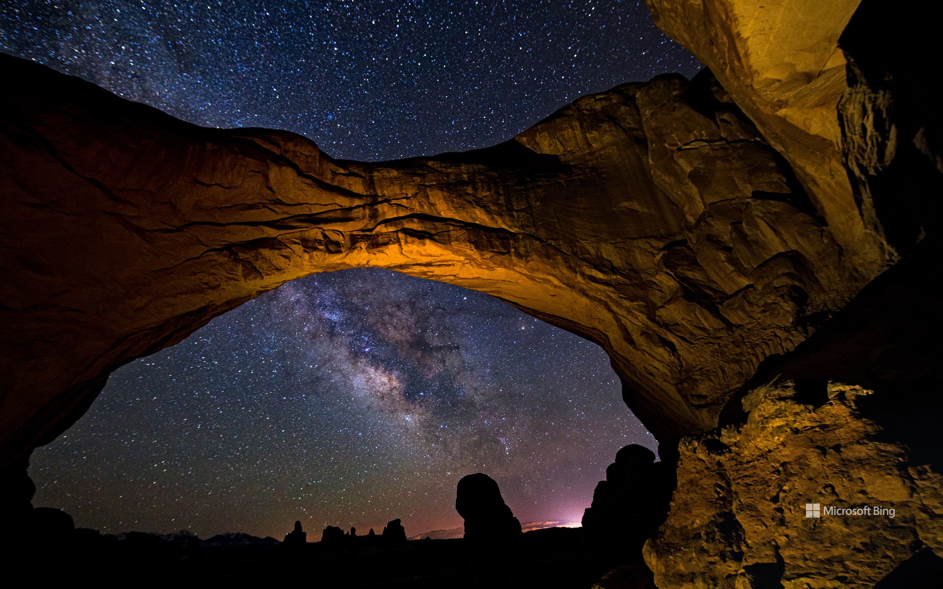
拱门国家公园双拱门映衬下的银河,犹他州,美国 The Milky Way framed by Double Arch in Arches National Park, Utah (© Adventure_Photo/Getty Images)
让我们一起庆祝宇宙 Let's celebrate the cosmos
国际天文日快乐!
你是否曾好奇,通过望远镜看到的土星环是什么样子?又或者,天文学家是如何发现遥远星系的?国际天文日正是探索这些奥秘的绝佳时机!这一年度活动最早于 1973 年发起,其官方主题是:“将天文学带给大众”。 从当地公园到天文俱乐部、博物馆,再到天文台,游客们可以参与望远镜观测、太空讲座,甚至体验模拟月球重力的装置!这一想法起源于加利福尼亚的一位天文学家道格·伯杰。他不再等待人们走进天文台,而是直接把望远镜带到热闹的公共场所。这一招奏效了,人们很快就迷上了仰望星空!如今,世界各地都在庆祝国际天文日,加拿大、瑞典、阿根廷等许多国家都有举办相关活动。今天,就是探索宇宙的好时机。找一架望远镜,一起仰望星空、庆祝宇宙的壮丽吧!
Happy International Astronomy Day!
Ever wondered what Saturn's rings look like through a telescope? Or how astronomers spot distant galaxies? International Astronomy Day is the perfect time to find out. This annual event, first launched in 1973, is all about 'Bringing Astronomy to the People'—the official theme of Astronomy Day. From local parks to astronomy clubs, museums, and observatories, visitors can enjoy activities like telescope viewings, space talks, and even moon gravity simulators.
The event started when Doug Berger, an astronomer in California, decided to take telescopes to busy public spaces rather than wait for people to visit observatories. It worked—people got hooked on stargazing. Astronomy Day is celebrated worldwide, with events in countries like Canada, Sweden, and Argentina, among many others. Today is the day to explore the universe. Find a telescope and celebrate the cosmos!
红木国家公园和州立公园, 加利福尼亚州, 美国 Grove of redwoods in Redwood National and State Parks, California (© Bob Pool/Getty Images)
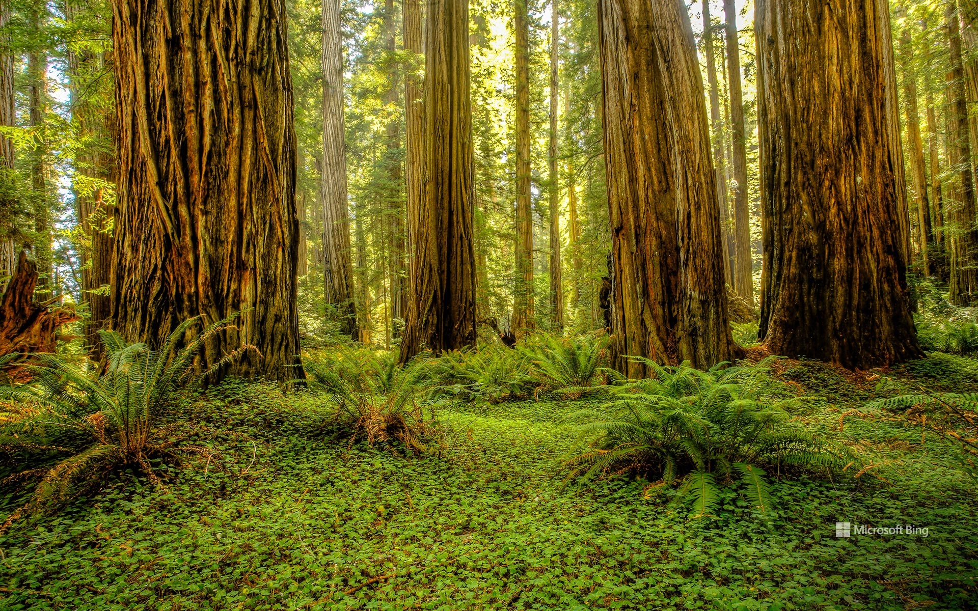
红木国家公园和州立公园, 加利福尼亚州, 美国 Grove of redwoods in Redwood National and State Parks, California (© Bob Pool/Getty Images)
就在这里驻足吧 Park it here
红木国家公园和州立公园, 加利福尼亚州
国家公园周今天落下帷幕,但这些森林已经庆祝大自然数千年了。走进一个树木直插云霄的世界。位于加利福尼亚州红木国家公园和州立公园的红木林,是地球上最高的树木之一,高达超过 370 英尺。州立公园包括红木国家公园、德尔诺特海岸红木州立公园、杰迪戴亚·史密斯红木州立公园和草原溪红木州立公园。有些红木树在玛雅人建造神庙和中国修建长城时就已经存在了。自 1968 年起被保护,这座公园保留了全球近一半现存的原始红木森林。
漫步于杰迪戴亚·史密斯红木州立公园的斯托特林地或红木国家公园的“第一夫人”林地中,能在红木树间享受宁静的漫步时光。您还可以徒步探索仅凭许可证才能进入的“高树小径”,在那里可以近距离观赏到这些最高的树木。红杉国家公园的生态系统是许多动物的家园,包括罗斯福麋鹿、黑熊、香蕉蛞蝓以及濒危的云雀鹱。在郁郁葱葱的树冠下,蕨类植物和苔藓茂盛生长,而沿海的雾气则为这些树木提供了不可缺少的水分。无论是徒步穿越这些参天巨树之间,还是仅仅站在它们的树荫下,这种体验都会令人感到心生敬畏。
Redwood National and State Parks, California
Step into a world where trees touch the sky. The redwood groves of Redwood National and State Parks (RNSP) in California are home to some of the tallest trees on Earth, soaring over 370 feet high. The combined RNSP contain Redwood National Park, Del Norte Coast Redwoods State Park, Jedediah Smith Redwoods State Park, and Prairie Creek Redwoods State Park. Some of these redwoods were alive when the Mayans built their temples, and the Great Wall of China was under construction. Protected since 1968, the park preserves nearly half of the world's remaining old-growth redwoods.
Walk through Stout Grove in Jedediah Smith Redwoods State Park or Lady Bird Johnson Grove in Redwood National Park for a quiet stroll among the redwoods. You can also hike the Tall Trees Trail, a permit-only path where you can closely witness the tallest trees. The RNSP ecosystem is home to many animals, including Roosevelt elk, black bears, banana slugs, and the endangered marbled murrelets. Ferns and moss thrive beneath the leafy canopy, while coastal fog provides essential moisture to the trees. Whether hiking beneath these towering giants or simply standing in their shadows, the experience is humbling.