标签 沼泽 下的文章
一片斜纹松和锯齿草大沼泽地国家公园,佛罗里达州,美国 A stand of slash pines and sawgrass prairie, Everglades National Park, Florida (© Jonathan Gewirtz/Tandem Stills + Motion)
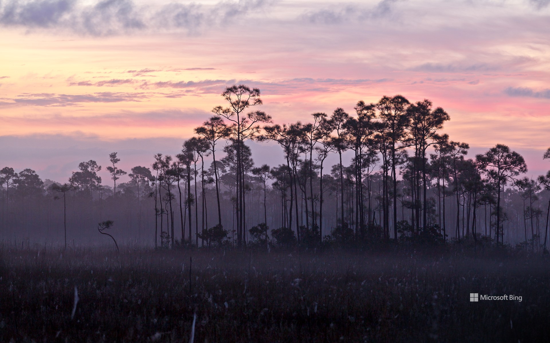
一片斜纹松和锯齿草大沼泽地国家公园,佛罗里达州,美国 A stand of slash pines and sawgrass prairie, Everglades National Park, Florida (© Jonathan Gewirtz/Tandem Stills + Motion)
欢迎来到大沼泽地 'Everglad' to be here
大沼泽地国家公园
90年前的今天,美国通过了一项法案,一个自然瑰宝也由此诞生:大沼泽地国家公园。这个位于佛罗里达州的公园囊括了美国最大的亚热带荒野。它占地150多万英亩,园区里生活着36种受联邦保护以及濒危的野生动物,如温顺的海牛、神秘的佛罗里达美洲豹。在这里,空气中回荡着350多种鸟类的叫声,如秧鹤、食螺鸢,水域中也是生机勃勃,有各种各样的鱼类,如锯盖鱼、红鱼,还有美洲鳄的身影。除了生物多样性之外,该公园还赢得了全球的认可,被联合国教科文组织评为世界遗产、国际生物圈保护区和国际重要湿地。因此,让我们向大沼泽地国家公园致敬!愿它可以继续为我们带来惊喜,并激发我们的好奇心以及欣赏周围野生世界的兴趣。
Everglades National Park marks 90 years
On this day 90 years ago, Congress passed an act that would lead to the creation of one of America's natural gems: Everglades National Park in Florida. It would be another 13 years before enough land was acquired to make the park a reality, but today it encapsulates the largest subtropical wilderness in the US. Spanning more than 1.5 million acres, the park is a lifeline to 36 federally protected and endangered wildlife species, from the gentle manatee to the stealthy Florida panther. Here, the air thrums with the calls of over 350 bird species like limpkins and snail kites, while the waters teem with life including hundreds of species of fish, sea turtles, and American crocodiles. Beyond its biodiversity, the park is celebrated as a UNESCO World Heritage Site, an International Biosphere Reserve, and a Wetland of International Importance. Here's to Everglades National Park—may it continue to inspire wonder, curiosity, and appreciation for the wild world around us.
布尔日的沼泽,法国 Marshes of Bourges, France (© Tuul & Bruno Morandi/Getty Images)
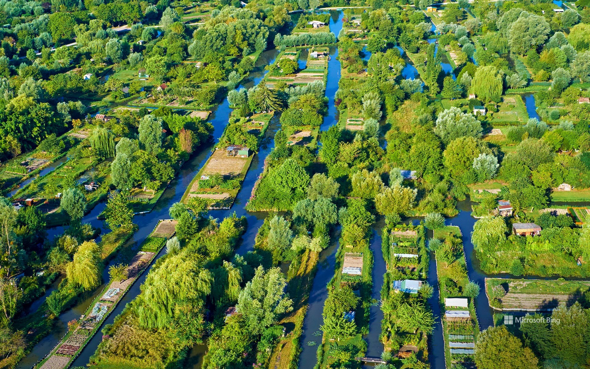
布尔日的沼泽,法国 Marshes of Bourges, France (© Tuul & Bruno Morandi/Getty Images)
城市中心的绿色天堂 'A haven of greenery in the heart of the city
布尔日沼泽,法国
布尔日沼泽位于布尔日城市的中心,占地135公顷,为人们提供了一个放松和探索的空间。在中世纪时期,这片沼泽地曾是抵御入侵的城市保护带。
今天,这些沼泽已经被分门别类地保护了起来,是法国仅存的商品蔬菜栽培沼泽之一。每年9月初这里会举行沼泽节日,届时会有彩灯花船游行和水上市场,为这里增添了节日气氛。这个神奇的地方会随着季节的变化而变化,吸引着无数的游客,无论是步行还是骑车,都可以一探这里独特的城市生态系统。
Labor Day
Labor Day is a well-earned day of rest for many workers across America. The food we eat, the shelter over our heads, and the transportation that moves us around all exist thanks to our collective labor. Organized labor movements grew in the 19th century, along with calls for a day to honor workers' contributions. The first Labor Day was celebrated with a parade in New York City in September 1882 and similar events spread throughout the country. In 1894, President Grover Cleveland signed a bill declaring the first Monday in September as Labor Day. Today, Labor Day marks the unofficial end of summer, but let's not forget to take a moment to give thanks for the work we all put in to take care of our communities, our families, and ourselves.
奥克弗诺基沼泽木板路上的西班牙苔藓,佐治亚州,美国 Spanish moss trees over a boardwalk in the Okefenokee Swamp, Folkston, Georgia (© Emmer Photo/Alamy)
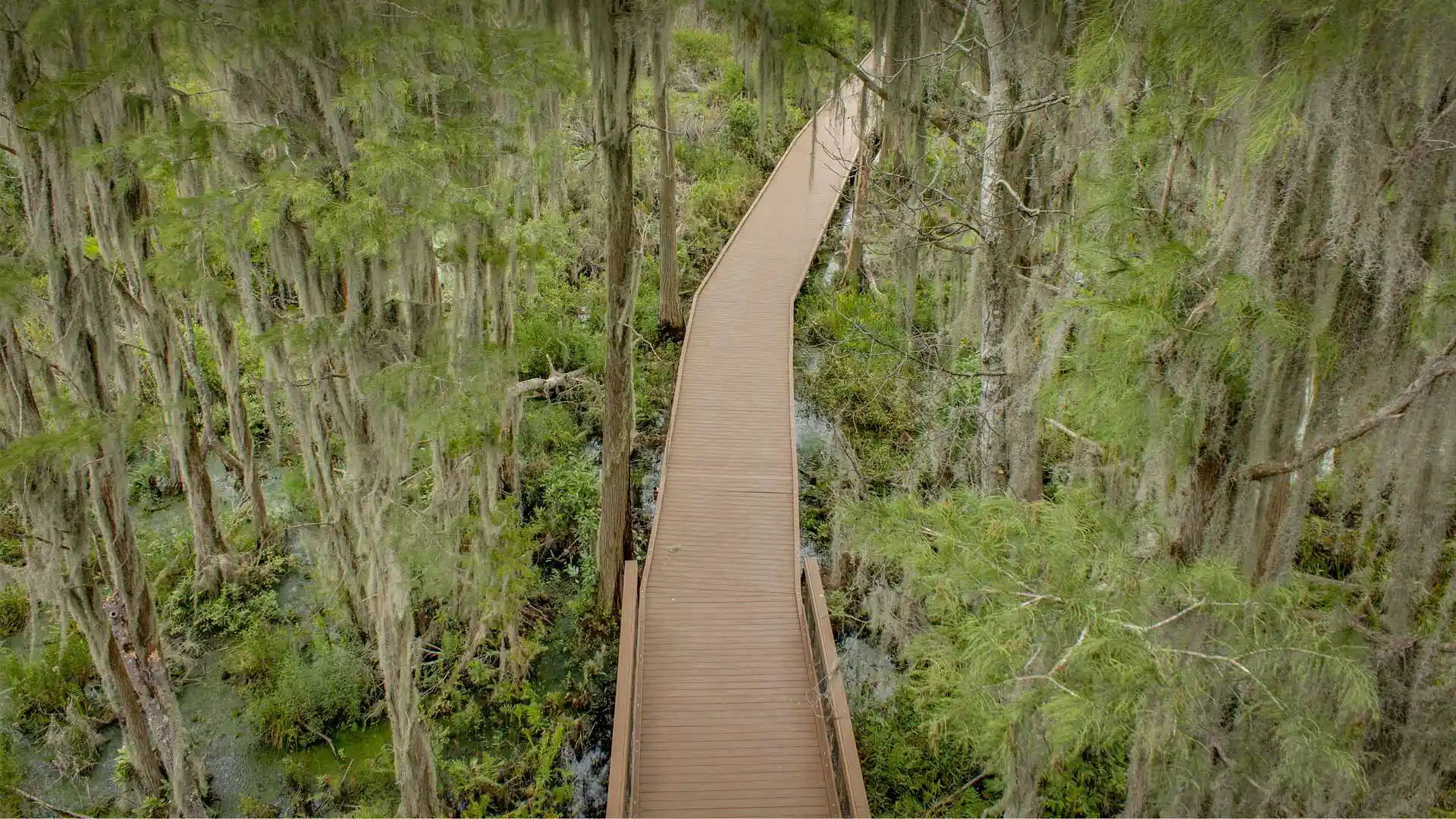
奥克弗诺基沼泽木板路上的西班牙苔藓,佐治亚州,美国 Spanish moss trees over a boardwalk in the Okefenokee Swamp, Folkston, Georgia (© Emmer Photo/Alamy)
你是否有勇气进入这片茂密的沼泽 Dare to delve into this dense swamp
奥克弗诺基沼泽
奥克弗诺基沼泽大部分位于佐治亚州东南部,是全美最大的淡水沼泽地。这片巨大又独特的生态系统覆盖了700平方英里的土地,生活着各种各样的野生动物,比如鹭、鹤、麻鸦、美洲短吻鳄、啄木鸟、乌龟、蛇、青蛙等。宁静的水域被有机物腐烂产生的单宁染成棕色。这片区域曾经是塞米诺尔印第安人的领地。到了现代,这片沼泽的一大部分已经被商业化了,这里的泥煤矿藏被作为燃料开采。
Okefenokee Swamp
The Okefenokee Swamp, on the border of Georgia and Florida, is the largest intact freshwater swamp in the US. Its slow-moving blackwaters are stained by tannins from decaying organic matter and this vast ecosystem, covering 700 square miles, is packed with wildlife. Herons, cranes, bitterns, American alligators, turtles, snakes, frogs, and Florida black bears are among creatures who roam the swamp, which is largely protected by the Okefenokee National Wildlife Refuge. In the early years of the 20th century, part of the swamp was logged, and its peat deposits were mined for use as fuel. Remnants of railroad lines can still be seen crossing swamp waterways as well as other equipment dating from its time as a logging area.
马萨诸塞州格洛斯特的沼泽地 Marshland, Gloucester, Massachusetts (© Thomas H. Mitchell/Getty Images)
马萨诸塞州格洛斯特的沼泽地 Marshland, Gloucester, Massachusetts (© Thomas H. Mitchell/Getty Images)
像一张油画 Like paint on a canvas
沼泽地,格洛斯特,美国马萨诸塞州
在新英格兰灿烂阳光的照耀下,这片盐沼地里的耐盐植物和海水形成了色彩鲜明的对比。盐沼是水生食物链中重要的一环,同时也是孕育野生动植物的温床。
这片沼泽位于美国最古老的海港——马萨诸塞州的格洛斯特。这个宁静的夏季度假胜地很受欢迎,游客们可以在这里享受新鲜捕获的美味海鲜、迷人的海滩、沼泽、划船、参观博物馆。尽管格洛斯特有种让人昏昏欲睡的小镇气息,但它距离繁华的波士顿只有45分钟车程。
Marshland, Gloucester, MA
Lit by bright New England sunshine, this salt marsh shows a strong contrast of color between the sea water and the salt-tolerant grass that grows there. Salt marshes serve as a major contributor to the aquatic food web and a nursery for wildlife, both terrestrial and aquatic.
These marshes are located in Gloucester, Massachusetts, America's oldest seaport. Tourists frequenting this tranquil summer vacation spot enjoy freshly caught delicious seafood, stunning beaches, marshes, museums, and boating. Though Gloucester may have a sleepy, small-town feel, it's only 45 minutes away from the bustling state capital city of Boston. Oh, and it's pronounced 'glosster' unless you're from Massachusetts—then it's 'glosstah.'
鸟瞰Mockhorn岛野生动植物管理区沼泽地内的潮汐通道,弗吉尼亚 Aerial view of tidal channels in marshland of the Mockhorn Island State Wildlife Management Area, Virginia (© Shane Gross/Minden Pictures)
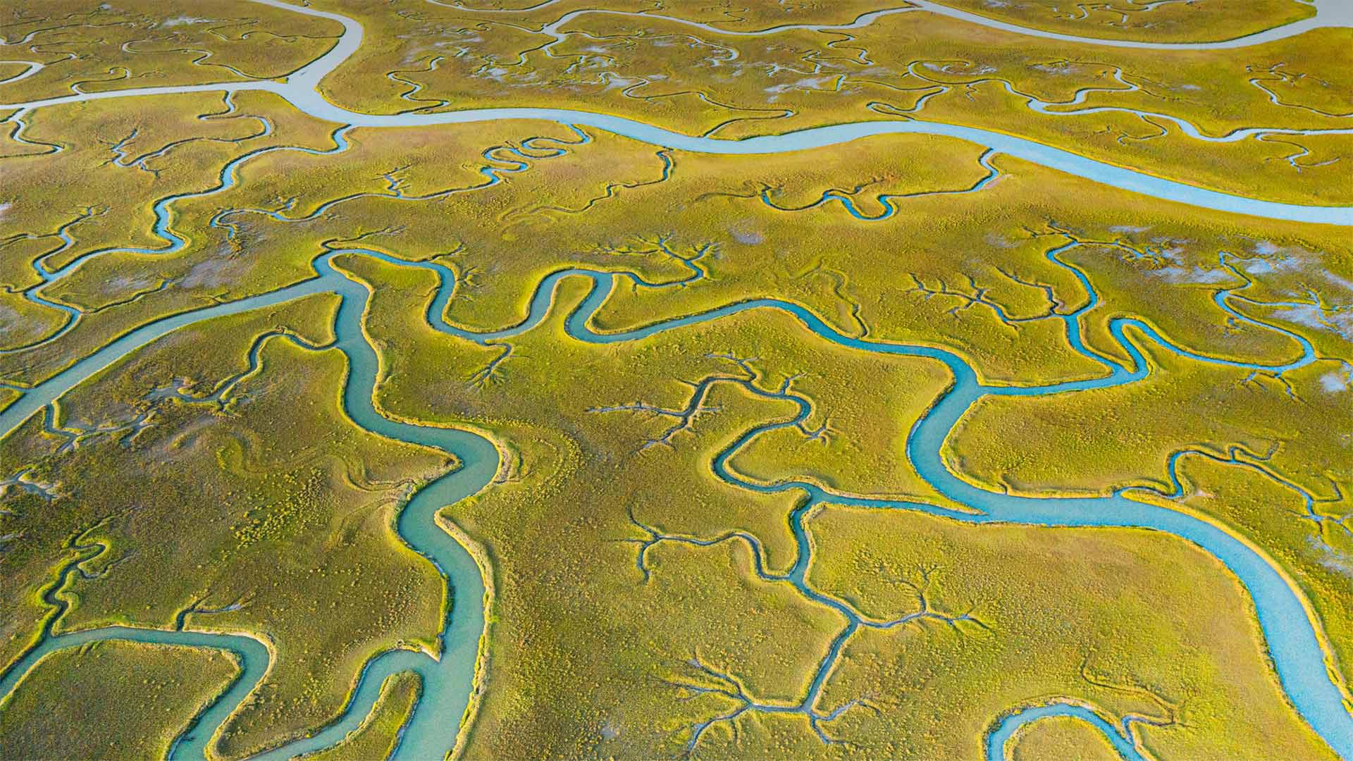
鸟瞰Mockhorn岛野生动植物管理区沼泽地内的潮汐通道,弗吉尼亚 Aerial view of tidal channels in marshland of the Mockhorn Island State Wildlife Management Area, Virginia (© Shane Gross/Minden Pictures)
When does the tide come in?
From the air, this tract of Mockhorn Island on the Atlantic coast of Virginia's Eastern Shore could pass for gentle farmland. But what you're really looking at is rugged tidal marshland, visible when the tide is out—the rest of the time, much of this area is underwater. Mockhorn is itself part of Virginia's coastal island chain called the Barrier Islands, which run down the east coast of the state from the Maryland-Delaware border for about 70 miles, stretching to the mouth of Chesapeake Bay. The green vegetation you see is grass, although not the kind you'll find in a suburban lawn. Instead, it's saltmarsh cordgrass, a type of perennial deciduous species that grows in wetlands and salt marshes like this one.
The only way to access the tidal channels of Mockhorn Island is by boat, and plenty of kayakers, hunters, and sport fishers are willing to brave the fickle, windy weather to enjoy the island's labyrinth of sloughs, bays, and inlets. The area's also a great destination for bird watchers, as many bird species fly directly overhead while migrating. Historically, the rugged terrain and remote location of the Barrier Islands made them a great place for those running from the authorities—it's said that pirates, including Blackbeard himself, spent time in hiding in the backwaters of this rugged coast.
潮水什么时候来?
从空中看,这片位于弗吉尼亚东岸大西洋海岸的莫克霍恩岛可以算是一片温和的农田。但你真正看到的是崎岖不平的潮汐沼泽地,其余时间退潮时可见,这一地区大部分都在水下。莫克霍恩岛本身是弗吉尼亚州海岸岛链的一部分,称为障壁群岛,从马里兰州与特拉华州的边界沿该州东海岸延伸约70英里,一直延伸到切萨皮克湾的河口。你看到的绿色植被是草,虽然不是你在郊区草坪上看到的那种。取而代之的是盐沼灯心草,一种多年生落叶植物,生长在湿地和盐沼中。
进入莫克霍恩岛潮汐通道的唯一途径是乘船,许多皮划艇手、猎人和运动渔民都愿意冒着变化无常、刮风的天气,享受岛上迷宫般的泥沼、海湾和水湾。该地区也是鸟类观察者的好去处,因为许多鸟类在迁徙时直接从头顶飞过。从历史上看,障壁岛崎岖的地形和偏远的地理位置使它成为那些逃避当局的人的好去处。据说海盗,包括黑胡子本人,都在这个崎岖的海岸的穷乡僻壤中躲藏了一段时间。