分类 必应美图 下的文章
塞里雅兰瀑布日落美景,冰岛 Seljalandsfoss waterfall at sunset, Iceland (© Tom Mackie/AWL/plainpicture)
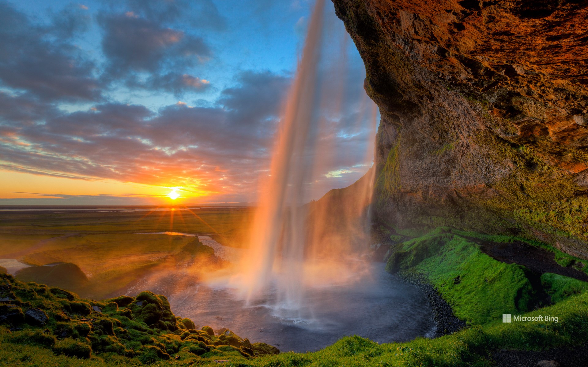
塞里雅兰瀑布日落美景,冰岛 Seljalandsfoss waterfall at sunset, Iceland (© Tom Mackie/AWL/plainpicture)
一切准备就绪,等待日落 Everything is ready, waiting for sunset
塞里雅兰瀑布,冰岛
这座197英尺高的瀑布从曾经标志着冰岛海岸线的悬崖峭壁倾泻而下。奔腾的瀑布是塞里雅兰河 (Seljalandsa River) 的一部分,发源于火山冰川埃亚菲亚德拉冰盖 (Eyjafjallajökull)。这座冰盖下的火山上次喷发是在2010年,对当地居民和空中交通造成了影响。游客可以走到瀑布后面的一个小洞穴,那里拥有独特的视角,也是摄影师的最爱。夜晚,泛光灯照亮了瀑布,营造出一幅梦幻般的景象。如果您计划在夏至期间度假,塞里雅兰瀑布 (Seljalandsfoss) 值得列入您的旅行清单。无论您是自然爱好者还是摄影爱好者,这次体验都将为您留下难忘的回忆。
瓦朗索勒高原的薰衣草田,法国 Lavender fields in Plateau de Valensole, France (© zpagistock/Getty Images)
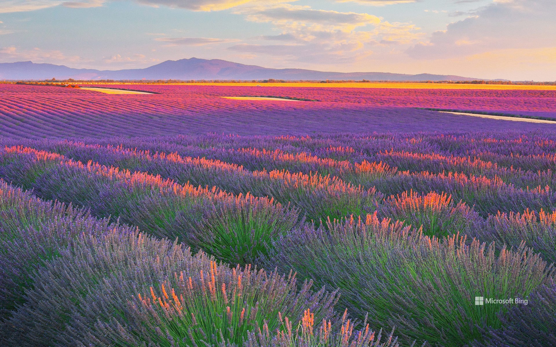
瓦朗索勒高原的薰衣草田,法国 Lavender fields in Plateau de Valensole, France (© zpagistock/Getty Images)
追随香气的地平线 Fragrant horizons
瓦朗索勒高原的薰衣草田,法国
若你正在寻找一场充满芬芳的夏日旅程,法国普罗旺斯的瓦朗索勒高原无疑是理想之选。从六月下旬至七月中旬,这片高原便会被紫色花海覆盖,宛如香气四溢的天然画布。高原坐落于海拔约1,900英尺的地带,面积达约300平方英里,是法国规模最大的薰衣草种植区之一。
薰衣草种植在该地区的兴起可追溯至19世纪,当时附近格拉斯地区的香水工业蓬勃发展。随着时间推移,薰衣草种植逐渐覆盖普罗旺斯,尤其集中在阳光充足、排水良好的高地地区,比如瓦朗索勒高原。如今,1700名种植者在大约62000英亩的土地上精心栽培这些薰衣草。所栽培的品种包括用于香水和护肤品的传统薰衣草,也种植茎更长的薰衣草杂交品种,常用于家居清洁用品和空气清新剂。瓦朗索勒的薰衣草田并非偶然的景致,而是香气与产业共生演化的结果。若希望尽情沉浸于这片紫色海洋之中,务必提前安排行程,循着薰衣草的香气,收获一个充满感官记忆的夏日。
Lavender fields in Plateau de Valensole, France
If you're looking for a scent-sational summer trip, follow your nose to the Plateau de Valensole in Provence, France. From late June to mid-July, this high plateau transforms into a purple sea of lavender. Situated more than 1,900 feet above sea level and spanning approximately 300 square miles, it is one of the largest areas in France dedicated to lavender cultivation.
Lavender has flourished in Provence for centuries. The ancient Romans brought the plant to southern France, using it for bathing, cooking, and healing. The word itself comes from 'lavare,' Latin for 'to wash.' By the Middle Ages, local monks were cultivating it for medicinal purposes. The real boom came in the 19th century, when the perfume industry in nearby Grasse took off. Over time, lavender fields spread across Provence, especially in high-sun, well-drained areas like Valensole. Today, 1,700 growers tend to around 62,000 acres of these shrubs. They cultivate both traditional lavender—for perfumes and skincare—and lavandin, the longer-stemmed cousin often found in household cleaning products and air fresheners. So don't just leave it to chance—plan ahead, follow the scent trail, and let your summer bloom with lavender memories.
菲莱神庙 (aka Temple of Isis), 阿斯旺, 埃及 Temple of Philae (aka Temple of Isis), Aswan, Egypt (© Ratnakorn Piyasirisorost/Getty Images)
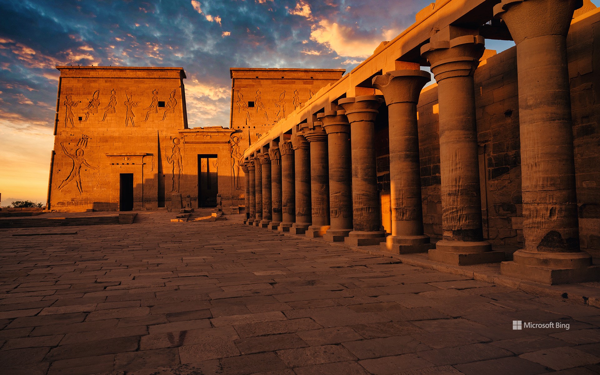
菲莱神庙 (aka Temple of Isis), 阿斯旺, 埃及 Temple of Philae (aka Temple of Isis), Aswan, Egypt (© Ratnakorn Piyasirisorost/Getty Images)
伊西斯女神的光辉照耀下 Illuminated by Isis
菲莱神庙, 阿斯旺, 埃及
菲莱神庙,常被称为伊西斯神庙,是埃及最迷人的古迹之一。它最初建在菲莱岛上,后来为避免被洪水淹没而迁至附近的阿吉勒基亚岛。这项迁移工程是20世纪60年代由联合国教科文组织发起的国际文物拯救项目,历时多年,搬运了逾4万块石块,才得以完整重建并保存这座古老神庙。如今,它坐落在尼罗河环绕的静谧之地,是乘船游览和探寻往昔的绝佳去处。
步入雄伟的门楼后,游客将进入一片立柱林立的庭院。主神庙供奉伊西斯女神,她是古埃及神话中掌管魔法、母性与守护的女神,神庙墙面雕刻生动讲述了关于她的神话传说。此外,遗址中还分布着供奉冥界之神奥西里斯(伊西斯的兄弟兼丈夫)与天空之神荷鲁斯(鹰头神)的小型神殿和祭祀堂。这处联合国教科文组织认定的世界遗产地可供游客自由探索,也可选择导览讲解。夜幕降临时,一场结合光影与音效的声光表演将古埃及神话栩栩如生地呈现眼前。这座神庙以其精美的浮雕艺术与良好的建筑保存状态,为世人揭示了古埃及文明的神秘与辉煌。
Temple of Philae, Aswan, Egypt
The Temple of Philae, often called the Temple of Isis, is one of Egypt's most enchanting ancient sites. Originally built on Philae Island, it was moved to nearby Agilkia Island to save it from flooding. The international rescue effort, launched by UNESCO in the 1960s, required a monumental effort that involved moving more than 40,000 stones. Today, it's a peaceful spot surrounded by the Nile—perfect for a scenic boat ride and a journey into the past.
To enter the temple complex, sightseers step through a grand gateway that leads to a courtyard lined with towering columns. The main temple is dedicated to Isis, the goddess of magic, motherhood, and protection, and its walls are covered in carvings that tell her story. Smaller chapels and shrines tucked around the site, including ones for Osiris (the Egyptian god of the underworld and brother-husband to Isis) and Horus (the sky deity depicted with a falcon head). Visitors can explore this UNESCO World Heritage Site freely or join a guided tour. At night, a sound-and-light show brings ancient myths to life. The temple's intricate carvings and well-preserved structures provide a fascinating glimpse into Egypt's ancient history.
英仙座流星雨和一棵古老刺果松,大盆地国家公园,内华达州,美国 Perseid meteor shower and an ancient bristlecone pine, Great Basin National Park, Nevada (© Wirestock Creators/Shutterstock)
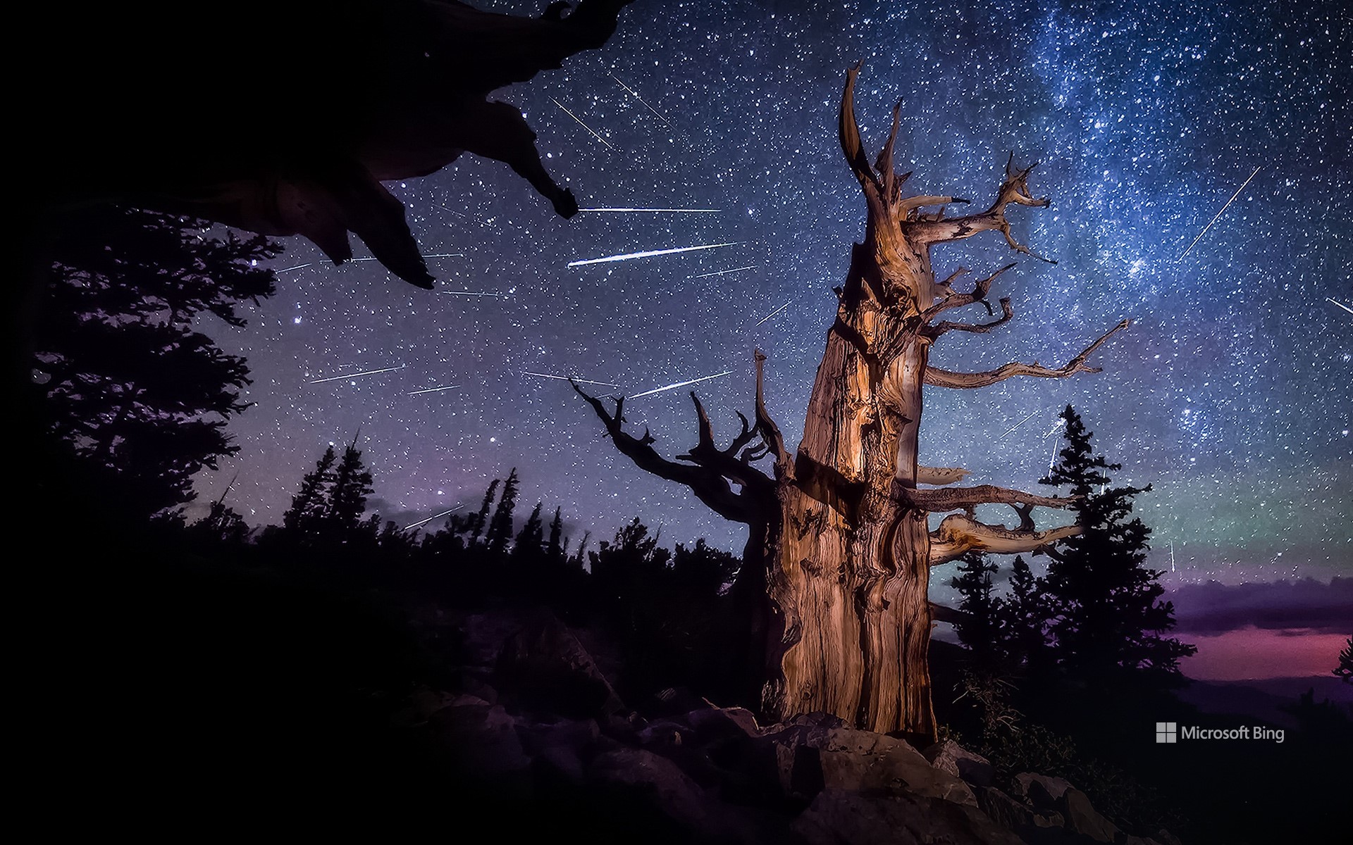
英仙座流星雨和一棵古老刺果松,大盆地国家公园,内华达州,美国 Perseid meteor shower and an ancient bristlecone pine, Great Basin National Park, Nevada (© Wirestock Creators/Shutterstock)
永恒的光芒 Timeless glow
英仙座流星雨照亮内华达
准备迎接一年中最耀眼的天文奇观之一英仙座流星雨吧!该流星雨每年活跃期为7月中旬至8月下旬,而今年的峰值将于8月12日夜间至13日凌晨上演璀璨盛景。当地球穿越彗星斯威夫特-塔特尔留下的冰岩碎片轨道时,形成了这一流星雨。这颗彗星上一次接近地球是在1992年。当这些尘埃颗粒以高速进入地球大气层时,会因摩擦而燃烧,划出一道道明亮的光痕。
若想尽情欣赏这场天文盛宴,北半球至中南纬度地区是最佳观测地点。今日图片所示地点为美国内华达州的大盆地国家公园。这里栖息着地球上最古老的非克隆植物狐尾松。这些树木在风雪与雨水的雕琢下,顽强生存了数千年,年复一年地守候着夜空中这场流星雨的盛会。
Perseid meteor shower over Nevada
Get ready for one of the most dazzling celestial displays of the year—the Perseid meteor shower. Active from mid-July through late August, this year it reaches its spectacular peak on the night of August 12 and into the early hours of August 13. The Perseids light up the skies when Earth passes through a trail of icy and rocky debris left behind by Comet Swift–Tuttle, which last passed close to our planet in 1992. These meteors are called the Perseids because they appear to streak from the direction of the constellation Perseus.
For those hoping to catch a glimpse of this breathtaking show, the Perseid meteor shower is best viewed from the Northern Hemisphere, extending down to the mid-southern latitudes. One such vantage point is Great Basin National Park in Nevada, seen in today's image, where ancient bristlecone pines stand beneath a sky ablaze with shooting stars. These remarkable trees are the oldest non-clonal species on Earth. Shaped by relentless wind, snow, and rain, they've endured for millennia—witnessing ice ages, volcanic eruptions, and the rise and fall of civilizations.
卡尔夫沙马尔斯维克湾玄武岩柱,斯卡吉半岛,冰岛 Basalt columns at Kálfshamarsvík, Skagi Peninsula, Iceland (© Arterra Picture Library/Alamy Stock Photo)
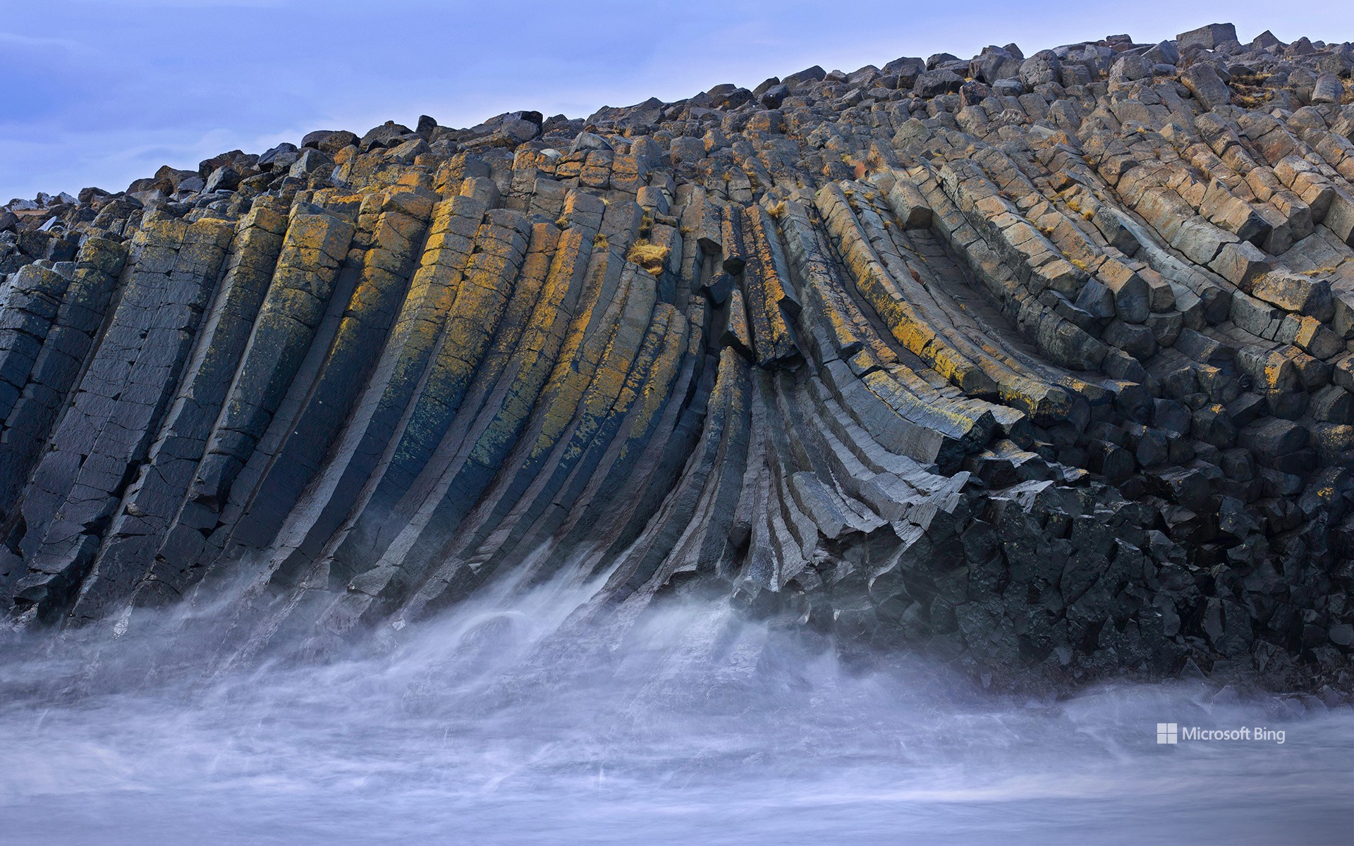
卡尔夫沙马尔斯维克湾玄武岩柱,斯卡吉半岛,冰岛 Basalt columns at Kálfshamarsvík, Skagi Peninsula, Iceland (© Arterra Picture Library/Alamy Stock Photo)
层层叠叠的岩石 Rockin' those layers
国际岩石日
你觉得岩石只是……岩石吗?这些天然的矿物组合不仅仅只是静静地待在原地,它们是地球地壳的基本组成单位,从石器时代的工具到为现代文明提供动力的矿物,岩石在人类发展史中发挥了重要作用。国际岩石日的设立,正是为了庆祝岩石在自然界及人类社会中的深远影响,激发公众对地质科学的兴趣,并鼓励人们欣赏岩石所展现的自然之美与多样性。
若想直观感受地质作用的壮观场景,冰岛无疑是理想之地。今日图片所示地点为冰岛北部偏远的斯卡格半岛,一处宁静的海湾:卡尔夫沙马尔斯维克。与冰岛著名的黑沙滩不同,这里布满了巨大的光滑鹅卵石,其周边高耸的海崖则清晰记录了该地区火山活动的历史。在这些海崖中,稀有的六边形玄武岩柱展现了火山地质作用的典范。这些看似人工雕琢的对称结构,实则为自然形成的地质奇观。这些玄武岩柱的形成可追溯至约两百万年前,当时大量玄武岩熔岩缓慢冷却,体积收缩并产生裂缝,裂缝逐步演化为规则的几何形状,最终形成近乎完美的六边形岩柱。尽管冰岛火山景观众多,但如此规模与规则性兼具的地貌极为罕见,使这片静谧的海湾显得尤为独特与珍贵。
Iceland for International Rock Day
Do you think rocks are just … well, rocks? These natural mineral combinations have done more than just sit around—they've built the Earth's crust and helped humans shape history. From Stone Age tools to the minerals powering modern civilization, rocks have been essential throughout our journey. International Rock Day celebrates this enduring impact, inviting us to explore the science of rocks, admire their natural beauty, and recognize the rich variety they add to our world.
If you're wondering where to see geology in action, Iceland is a great place to explore. Today's image takes us to Kálfshamarsvík—a secluded cove on the country's remote Skagi Peninsula. Unlike Iceland's famous black sand beaches, this cove's shore is strewn with large, smooth pebbles, while its fiery volcanic past still reveals itself in the towering cliffs. Here, evidence of volcanic activity is on full display in the form of rare hexagonal basalt columns. These sea cliffs are shaped into natural sculptures so symmetrical that they look almost human-made. These striking formations were created around 2 million years ago, when thick basalt lava cooled slowly, contracting and cracking into geometric shapes that form near-perfect hexagons. Though Iceland is full of volcanic marvels, formations like these are rare, making this quiet cove truly remarkable.
日出时的东京,日本 Tokyo at sunrise, Japan (© pongnathee kluaythong/Getty Images)

日出时的东京,日本 Tokyo at sunrise, Japan (© pongnathee kluaythong/Getty Images)
把我们都算上 Counting us all in
世界人口日
我们生活的地球早已人满为患,并且仍在不断变得更加拥挤。目前全球人口已达82亿,且呈持续增长之势。世界人口日旨在引发人们对人口增长如何影响城市发展、粮食供给与未来前景的思考。该纪念日设立于1989年,聚焦于不受控的人口增长对可持续性带来的影响,其灵感源自1987年全球人口首次突破50亿的“50亿人口日”。随着城市不断扩张,绿地面积减少,农业也在有限的土地和水资源中展开竞争。然而前路并非无解:通过教育投资、改善医疗可及性,以及建设更智慧的城市,人口增长与可持续发展之间可以实现平衡。
从全球数据来看,至2025年,印度仍将是全球人口最多的国家,人口数预计超过14.6亿;其次是中国,人口约14.1亿;美国以约3.39亿人口位居第三,尽管其增长速度趋缓,人口老龄化正成为新的社会挑战。当前全球人口最多的城市是日本东京,人口约3,720万,它呈现出高密度城市生活的实际图景:空间紧张、交通拥堵,以及公共服务需求高企。世界人口日不只是人口统计,更是呼吁我们要进行具前瞻性的规划,以确保子孙后代能在资源有限的地球上能持续繁荣发展。
World Population Day
We are living in a full house, and it is getting fuller. With 8.2 billion people and counting, World Population Day highlights how that growth affects cities, food, and the future. First observed in 1989, the day focuses on how unchecked population growth affects sustainability. The event was inspired by Five Billion Day in 1987, which marked the approximate date when the global population hit that milestone. As cities expand, green spaces shrink, and agriculture competes for limited land and water resources. But there is a way forward—investing in education, improving access to healthcare, and building smarter cities can balance growth with sustainability.
On a global scale, India remains the most populous country in 2025 with over 1.46 billion people, followed by China at 1.41 billion. The United States trails with around 339 million, though its growth is slowing and aging populations are becoming a new challenge. Tokyo, the world's largest city with around 37.2 million people, illustrates the realities of high-density urban life: overcrowded spaces, transport congestion, and rising demand for services. World Population Day is more than a head count—it's a call for better planning and long-term thinking to ensure future generations can thrive on a planet with finite resources.
巴哈马的绿松石色水域 Turquoise waters of the Bahamas (© BlueOrange Studio/Adobe Stock)
巴哈马的绿松石色水域 Turquoise waters of the Bahamas (© BlueOrange Studio/Adobe Stock)
奔向自由之浪 To the waves of freedom
Independence Day of the Bahamas
The Bahamas comes alive with color, music, and pride today as the nation marks its Independence Day. First recorded by Europeans in 1492 when Christopher Columbus arrived, the islands were initially under Spanish rule. They later came briefly under American control before becoming a British colony. After decades of legal negotiations and a growing push for self-governance, the Bahamas transitioned to full independence on this day in 1973.
In the lead-up to July 10, Bahamians across the archipelago take part in spirited celebrations, including National Pride Day, ecumenical services, and community walks and runs. These events shine a spotlight on the nation's vibrant culture, heritage, and deep sense of patriotism. And what better backdrop for such festivities than the breathtaking turquoise waters that surround the islands? The shallow, white sandbanks reflect sunlight in a way that gives the ocean its signature electric-blue glow, pictured here. Whether you're snorkeling among coral reefs, watching fireworks from a beachfront, or cruising the Exuma Cays under the golden sun, it seems the ocean sparkles just a little brighter on Independence Day.
宪法火车站,布宜诺斯艾利斯,阿根廷 Constitución railway station, Buenos Aires, Argentina (© Grafissimo/Getty Images)

宪法火车站,布宜诺斯艾利斯,阿根廷 Constitución railway station, Buenos Aires, Argentina (© Grafissimo/Getty Images)
具有纪念意义的火车站 The rise of a republic
阿根廷的独立纪念日
今天是阿根廷的独立日。这片拥有辽阔潘帕斯草原、丰富文化遗产与鲜明民族认同的南美国家,于1816年在图库曼省圣米格尔市正式宣告独立,摆脱西班牙的殖民统治。通往独立的道路充满挑战,伴随着长期内战与政治动荡;而阿根廷的独立运动也深受美国和法国独立运动的影响。最终,阿根廷人民以坚定不移的意志赢得了国家的自由。
独立之后,阿根廷逐步构建现代国家体系。1853年,该国颁布了第一部宪法,为后来的民主制度奠定了法律基础,这部宪法至今仍影响着国家政治运作。在文化和体育领域,阿根廷也在全球舞台上留下了深刻印记:文学巨匠豪尔赫·路易斯·博尔赫斯的作品影响深远;阿萨多(阿根廷传统烧烤)体现了其深厚的饮食文化;而像迭戈·马拉多纳与莱昂内尔·梅西这样的世界级足球运动员更是国家精神的象征。今日图片中的布宜诺斯艾利斯的宪法火车站,是该国重要的铁路交通枢纽,象征着国家发展、互联互通的精神,也是那个变革年代所孕育出的团结意志的缩影。
Independence Day of the Argentine Republic
Argentina, a nation of sweeping pampas, rich culture, and a bold identity, celebrates its Independence Day today. This pivotal date marks the moment in 1816 when delegates from across the region gathered in the city of San Miguel de Tucumán to declare freedom from Spanish colonial rule. The road to independence was not easy; it followed years of internal struggles and revolutions influenced by global movements, including the American and French revolutions. But the resolve of the Argentine people prevailed.
Since gaining independence, Argentina has taken important steps in shaping its national identity. The drafting of its first constitution in 1853 established a framework for democratic governance that continues to influence its political system. The country has also made notable contributions to global culture and sports. It has offered the world literary figures like Jorge Luis Borges, a rich culinary tradition centered on asado (a traditional barbecue), and legendary athletes such as Diego Maradona and Lionel Messi. Constitución railway station in Buenos Aires, pictured here, is a historic hub that reflects Argentina's drive for growth, connectivity, and the spirit of unity that emerged during a transformative era.
塞切达,多洛米蒂山脉的山峰,南蒂罗尔,意大利 Seceda, a peak in the Dolomites, South Tyrol, Italy (© Kalyakan/Adobe Stock)
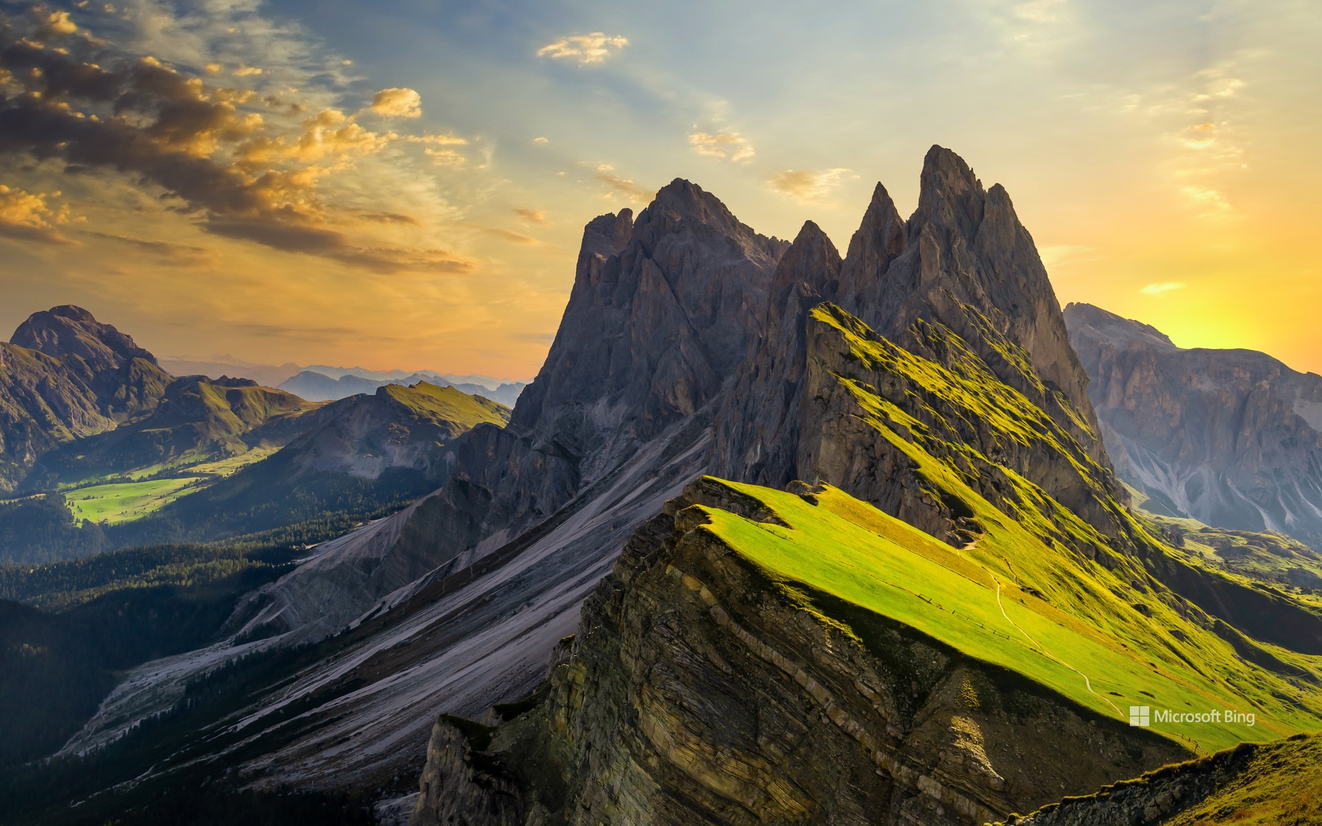
塞切达,多洛米蒂山脉的山峰,南蒂罗尔,意大利 Seceda, a peak in the Dolomites, South Tyrol, Italy (© Kalyakan/Adobe Stock)
锋芒毕露的美 Beauty with an edge
塞切达,多洛米蒂山脉的山峰,南蒂罗尔,意大利
意大利多洛米蒂山脉不仅雄伟耸立,更如施展魔法般,使每一条山路都变成一个故事。人们亲切地称它们为“苍白山脉”,这一名字源自其主要构成矿物白云石。这片山脉坐落于意大利北部阿尔卑斯山脉,占地超过34.5万英亩,拥有18座海拔超过9,500英尺的高峰。其地貌特征包括陡峭的悬崖、雄伟的岩壁和蜿蜒狭窄的山谷。
在多洛米蒂山的壮丽景色之中,坐落着其最壮观的山峰之一塞切达,正是今日图中所示。它海拔约8200英尺,是南蒂罗尔省瓦尔加迪纳山谷中最高的全景观景台。乘坐缆车即可轻松抵达山顶,省去原本艰难的登山行程。登顶之后,映入眼帘的是多洛米蒂山标志性的锯齿状山脊线的壮丽全景。在晴朗的日子里,甚至可以远眺90多英里外的奥地利最高峰格洛克纳山。
Seceda, Dolomites, South Tyrol, Italy
Italy's Dolomites don't just tower; they enchant, turning every trail into a story. Fondly known as the 'Pale Mountains,' the Dolomites derive their name from dolomite—a carbonate mineral. Set in the northern Italian Alps, the range spans over 345,000 acres and boasts 18 soaring peaks that rise above 9,500 feet. These mountains feature sheer cliffs, lofty walls, and a maze of narrow, winding valleys.
Amid the dramatic landscape of the Dolomites lies one of its most spectacular peaks, Seceda, featured in today's image. With a height of around 8,200 feet, it offers the highest panoramic viewpoint in Val Gardena, a scenic valley in the province of South Tyrol. A short cable car ride takes you to the summit, bypassing what would otherwise be a strenuous hike. Once at the top, you're greeted by a stunning sweep of the Dolomites' iconic jagged ridgelines. On a clear day, you might even spot Austria's tallest mountain, the Großglockner, located more than 90 miles away.
死亡谷国家公园的梅斯基特平原沙丘,加利福尼亚州,美国 Mesquite Flat Sand Dunes in Death Valley National Park, California (© Bryan Jolley/TANDEM Stills + Motion)
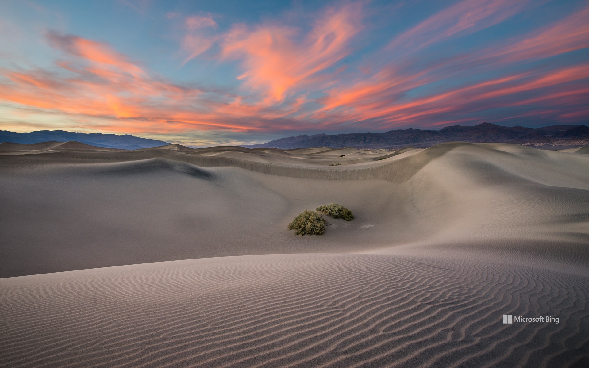
死亡谷国家公园的梅斯基特平原沙丘,加利福尼亚州,美国 Mesquite Flat Sand Dunes in Death Valley National Park, California (© Bryan Jolley/TANDEM Stills + Motion)
时光沙丘 Sands of time
梅斯基特平原沙丘,死亡谷国家公园
梅斯基特平原沙丘位于死亡谷国家公园内的斯托夫派普韦尔斯村附近,是公园内最易到达且最具标志性的沙丘。它们由北侧山脉风化提供的沙源、盛行风的搬运作用,以及南侧山脉的阻挡所共同作用形成,造就了这片波纹起伏的壮美景观。沙丘以在恶劣环境中依旧顽强生长的蜜荆树命名。在日出和日落时分,沙丘的纹理和棱线在光影映照下格外分明,是欣赏日照美景与星空观测的绝佳地点。
死亡谷国家公园占地超过340万英亩,是美国本土面积最大的国家公园。它以极端气温、广袤沙漠景观和多样地貌著称。超过93%的公园区域被指定为荒野保护地,适合进行深度探险,但游客需警惕高温、突发洪水及野生动物等潜在危险。尽管环境恶劣,这片土地却拥有丰富的自然美景与人文历史,包括与在此世代生活的廷比沙肖肖尼原住民深厚的文化渊源。
Mesquite Flat Sand Dunes in Death Valley National Park, California
The Mesquite Flat Sand Dunes, located near Stovepipe Wells Village in Death Valley National Park, are the most accessible and iconic dunes in the park. They are formed by a combination of eroding mountains to the north that supply sand, prevailing winds that move it, and surrounding mountains that trap it from the south—creating a stunning landscape of rippling sand hills. Named after the resilient mesquite trees that grow here, the dunes offer breathtaking views at sunrise and sunset, as well as exceptional stargazing opportunities.
Death Valley National Park, spanning more than 3.4 million acres, is the largest national park in the contiguous United States. It is known for its extreme temperatures, vast desert landscapes, and geological diversity. More than 93% of the park is designated wilderness, offering opportunities for backcountry exploration, though visitors must be cautious of hazards like extreme heat, flash floods, and wildlife. Despite its harsh environment, the park is rich in natural beauty and cultural history, including its deep ties to the Timbisha Shoshone people, who have lived in the region for generations.