标签 火山 下的文章
克里穆图的火山口湖,弗洛勒斯岛,印度尼西亚 Volcanic crater lakes on Kelimutu, Flores, Indonesia (© Shane P. White/Minden Pictures)
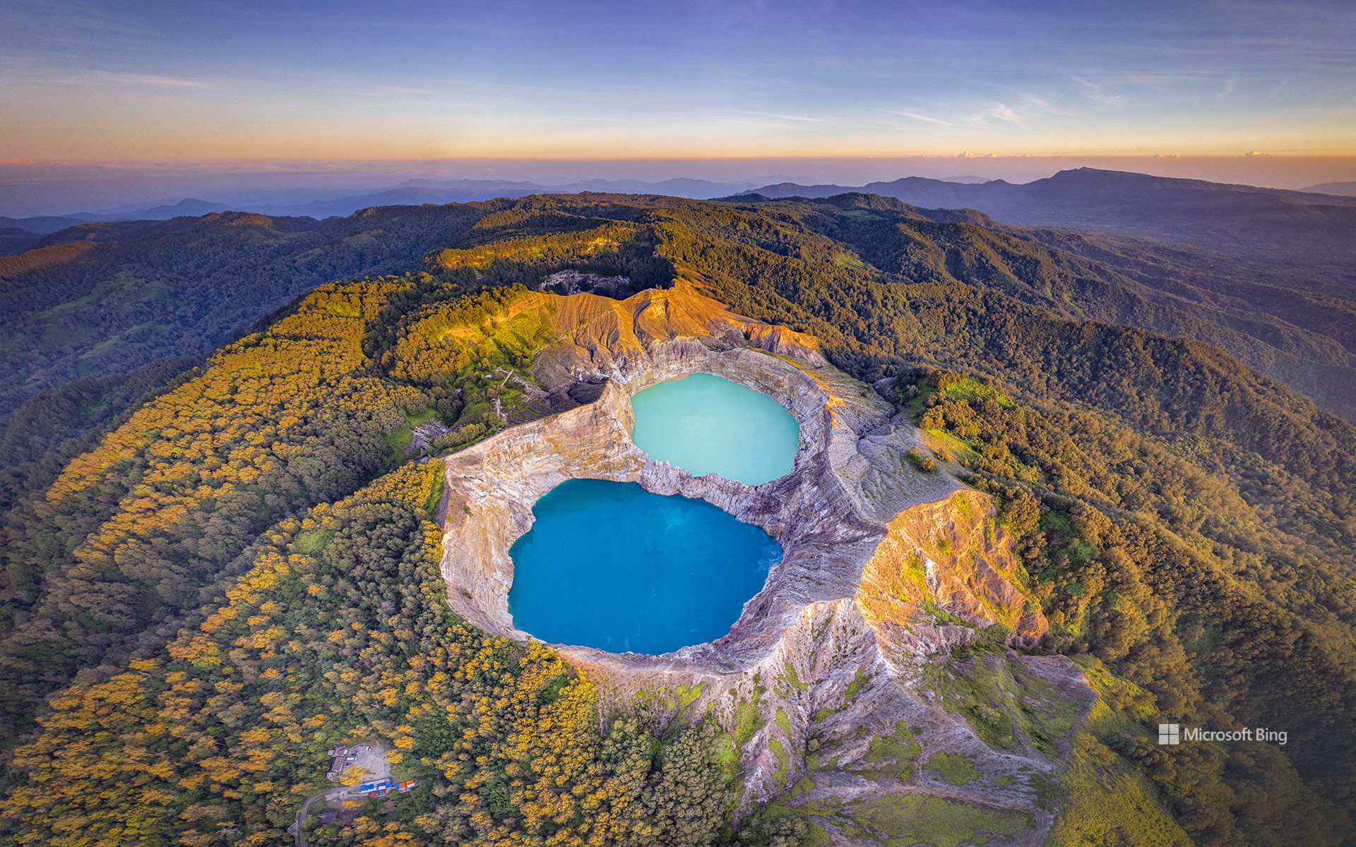
克里穆图的火山口湖,弗洛勒斯岛,印度尼西亚 Volcanic crater lakes on Kelimutu, Flores, Indonesia (© Shane P. White/Minden Pictures)
让人心旷神怡的美景 The views will blue your mind
克里穆图,弗洛勒斯岛,印度尼西亚
也许您以前见过一些颜色独特的湖泊,但是当您看到印度尼西亚的弗洛勒斯岛上的克里穆图火山口湖后,可能还是会大吃一惊。这个自然奇观拥有三个湖泊,每个湖泊都有自己的颜色和民间传说,吸引着那些寻求超凡脱俗旅行体验的游客。地球深处的火山喷口释放出蒸汽和气体,改变了这些湖泊的矿物成分,导致它们的外观颜色会发生周期性变化。克里穆图的每一个火山口湖都有自己独特的化学成分,这就是为什么它们可以同时呈现不同的颜色,并且这些颜色可以独立变化。最西边的老人湖通常呈现出蓝色调,与此同时,青年湖通常呈现出绿色调,而魔力湖则通常呈现出红色调。当地的利奥人崇敬这些湖泊,认为它们是灵魂的安息之地。如果您已经厌倦了普通的海边旅行,不妨去克里穆图探索这三个能变色的神奇湖泊。
Kelimutu, Flores, Indonesia
You might have seen lakes with some unique colors before, but Indonesian island of Flores, with its volcano Kelimutu, may steal the show. Home to three lakes, each with its own hue and folklore, this natural wonder attracts travelers seeking an otherworldly experience. Volcanic vents deep within the Earth release steam and gas, which alter the lakes' mineral compositions, causing reactions that transform their appearance periodically. Each lake on Kelimutu has its own unique chemical makeup, which is why they can be different colors from each other at the same time, and these colors can change independently. The westernmost lake, Tiwu Ata Bupu (Lake of Old People), normally has a blue hue. Meanwhile, Tiwu Ko'o Fai Nuwa Muri (Lake of Young Men and Maidens) tends to be green, and Tiwu Ata Polo (Bewitched or Enchanted Lake) is usually red.
The local Lio people revere these lakes, believing them to be the resting place of souls. So, why settle for the usual beachside vacation when you can explore a trio of color-changing lakes?
从蒙特维多看到的阿雷纳尔火山, 哥斯达黎加 Arenal Volcano seen from Monteverde, Costa Rica (© Lukas Bischoff/Getty Images)
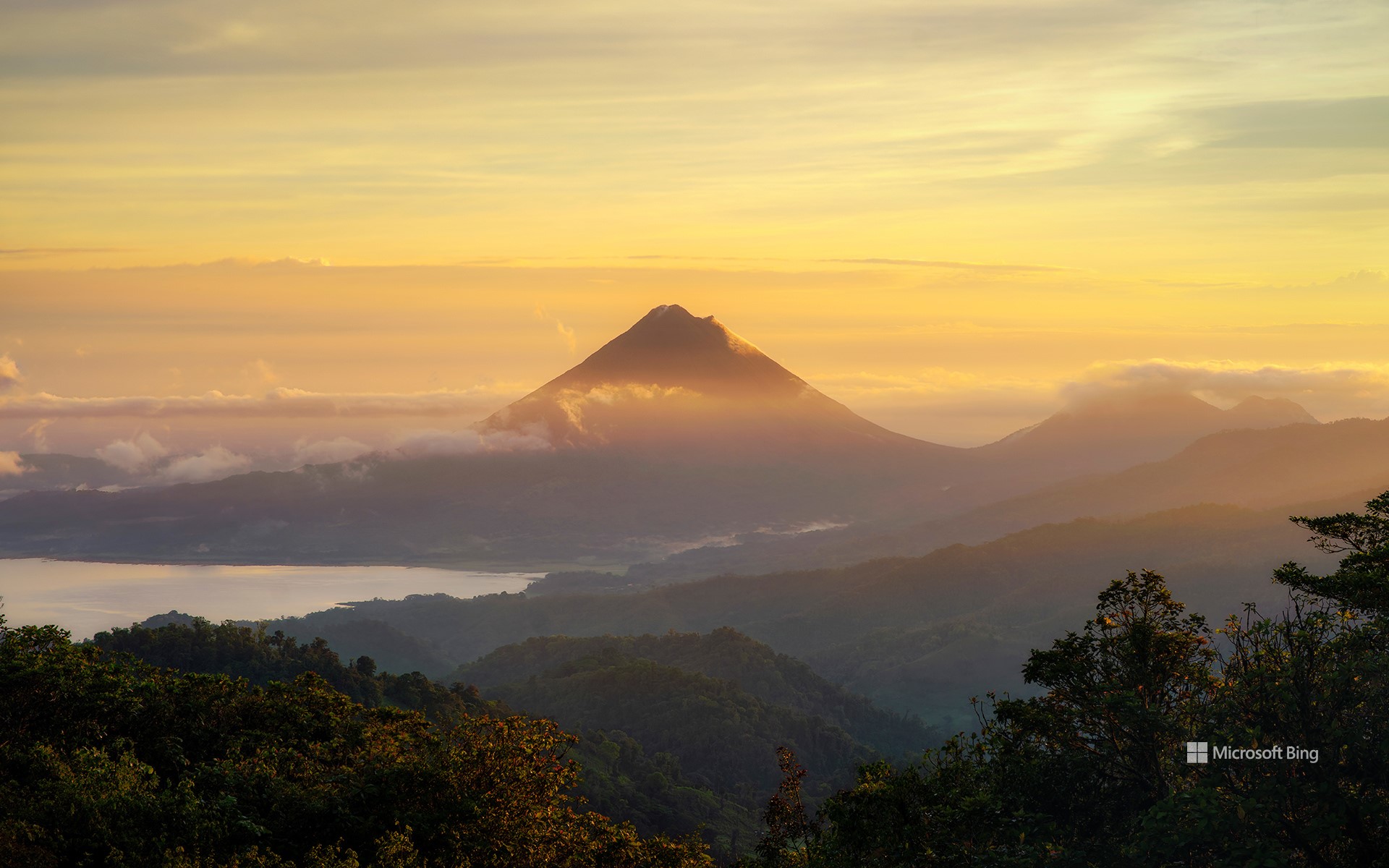
从蒙特维多看到的阿雷纳尔火山, 哥斯达黎加 Arenal Volcano seen from Monteverde, Costa Rica (© Lukas Bischoff/Getty Images)
睡美人 A sleeping beauty
睡美人
热带国家哥斯达黎加在向你招手!图中展示的圆锥形的阿雷纳尔火山高达5437英尺,屹立于周围的热带雨林以及该国最大的湖泊阿雷纳尔湖之上。1968年,在一次大规模的喷发中,这座沉睡的火山咆哮着苏醒了,当时的岩石飞溅了半英里多。而最近一次的大规模火山活动发生在2010年,如今,这座曾被熔岩照亮过山峰正处于休眠状态。对于观鸟者而言,阿雷纳尔火山国家公园是一个必游之地,公园内拥有500多种鸟类,除此之外,该公园还是各种动植物的家园,包括赤短角鹿、美洲狮、白脸卷尾猴、兰花、蝎尾蕉和蕨类植物。高高的阿雷纳尔火山俯瞰着这些热带树木,形成了一副壮观而美丽的风景。
Arenal Volcano, Costa Rica
Greetings from tropical Costa Rica! The conical Arenal Volcano rises to an impressive height of 5,437 feet, standing tall above the surrounding rainforest and Lake Arenal, the largest lake in the country. The sleepy mountain roared to life in a massive 1968 eruption that buried about 6 square miles under rocks, lava, and ash and devastated three villages. The last significant volcanic activity there took place in 2010, and the once lava-lit peak is currently dormant. With over 500 species of birds, Arenal Volcano National Park is a must-visit location for birdwatchers. The park is also home to a diverse range of flora and fauna, including red brocket deer, pumas, white-faced monkeys, orchids, heliconias, and ferns. Arenal makes for an imposing and beautiful sight, towering over the tropical trees.
城山日出峰,济州岛上的凝灰岩锥,韩国 Seongsan Ilchulbong, a tuff cone on Jeju Island, South Korea (© Quynh Anh Nguyen/Getty Images)
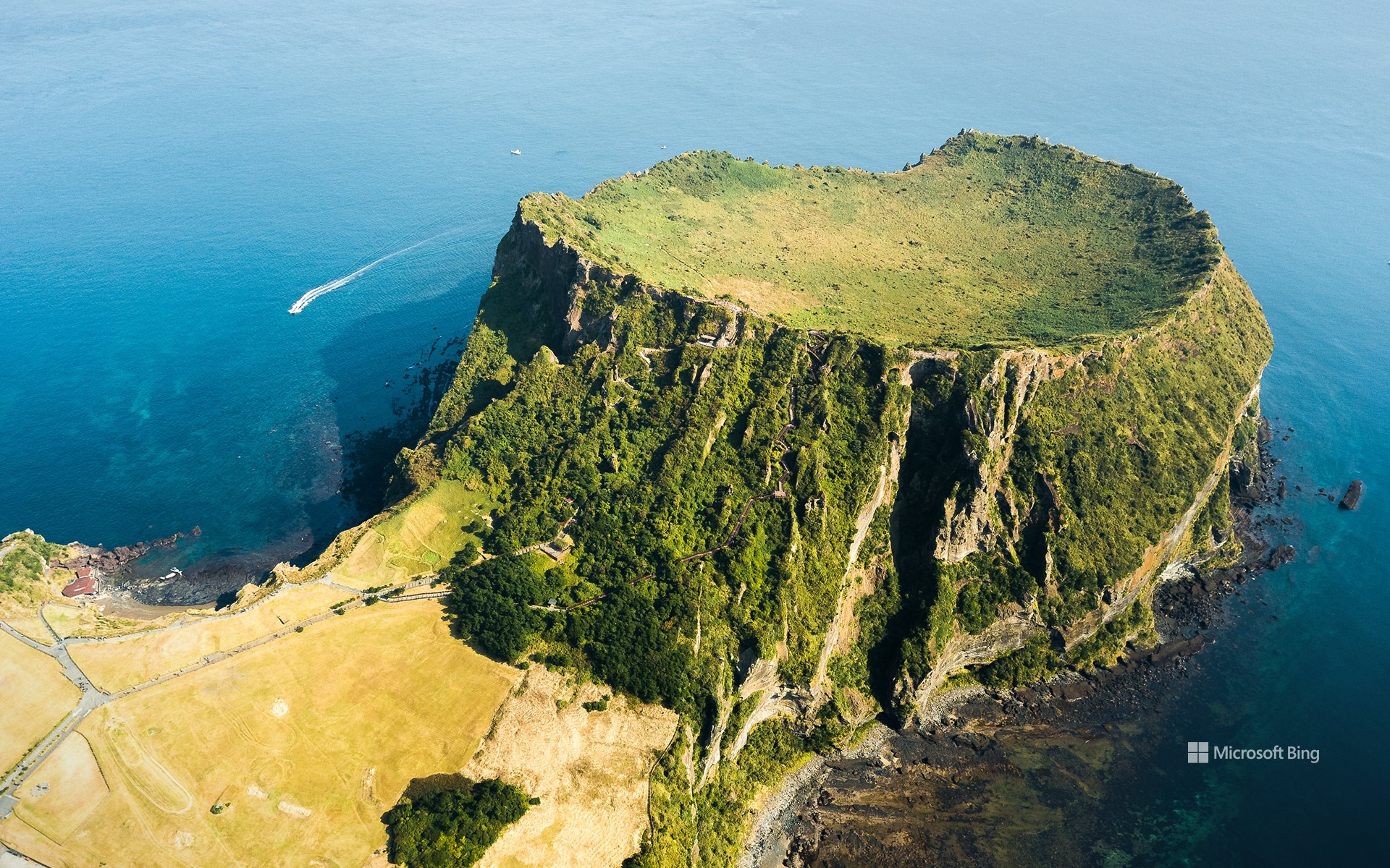
城山日出峰,济州岛上的凝灰岩锥,韩国 Seongsan Ilchulbong, a tuff cone on Jeju Island, South Korea (© Quynh Anh Nguyen/Getty Images)
一个酷炫的凝灰岩火山口 A 'tuff'-tastic crater
济州岛,韩国
济州岛上充满奇观,火山、古老石像、瀑布和岩石海岸,还有今天图片中的主角,城山日出峰,是岛上罕见的凝灰岩锥,由5000年前的一次海底火山喷发而形成。城山日出峰于2007年被列入联合国教科文组织世界自然遗产名录。
Jeju Island, South Korea
The South Korean island of Jeju is full of wonders. If you don't have a chance to visit its volcanic landscape, ancient stone statues, waterfalls, and rocky coastline, you can dive into the island's fascinating chronicles from the comfort of your computer. The star of today's image, Seongsan Ilchulbong (Sunrise Peak), is the island's rare tuff cone formation, created by an underwater volcanic eruption about 5,000 years ago. Tuff cones are also called ash cones, referring to the accumulated ash settling in a cone formation after the lava's forceful explosion. Seongsan Ilchulbong was added to the UNESCO World Natural Heritage List in 2007.
阿雷纳尔火山,蒙泰韦尔德,哥斯达黎加 Arenal Volcano seen from Monteverde, Costa Rica (© Kevin Wells/Getty Images)
阿雷纳尔火山,蒙泰韦尔德,哥斯达黎加 Arenal Volcano seen from Monteverde, Costa Rica (© Kevin Wells/Getty Images)
为了每个人,保护地球的生物多样性 Protecting Earth's biodiversity for everyone
世界生物多样性日
今天是世界生物多样性日,也是个回顾生物多样性在人类历史发展和续存过程中的关键作用的机会。从细菌、基因到整个生态系统,生物多样性囊括所有形式的生命,包括珊瑚礁、雨林和海洋环境等。我们的水、食物、药品、衣服、住所和能源都依赖于健康的生态系统。
在地方生态系统对世界生物多样性的影响方面,哥斯达黎加的蒙特维多云雾森林是个完美范例。这片森林是哥斯达黎加约一半生物的家园,占世界生物多样性的2.5%。今天,我们可以认真思考人类与世界生态系统的关系,并努力成为更好的地球管家。
International Day for Biodiversity
It’s International Day for Biological Diversity, a day to celebrate the variety of life on Earth in all its forms, from bacteria, plants, and animals to entire ecosystems like coral reefs and rainforests. All living things within each ecosystem are interconnected, and we rely on healthy ecosystems for our water, food, medicines, clothes, energy, and shelter. But many species are threatened with extinction and ecosystems are being destroyed, which mean Earth’s rich biodiversity is in decline.
Our homepage image shows Costa Rica’s Monteverde Cloud Forest, home to about half of all species in the country, including more than 2,500 types of plants and 400 bird species. Here you’ll find jaguars and pumas living alongside sloths, howler monkeys, and the endangered resplendent quetzal. This forest alone represents about 2.5% of the world’s biodiversity, the perfect ambassador for today’s event, which calls on us to rethink our relationship with nature and work to be better stewards of the Earth.
普埃布拉天主堂和波波卡特佩特火山,普埃布拉,墨西哥 Church of Nuestra Señora de los Remedios and Popocatépetl, Puebla, Mexico (© Radius Images/Shutterstock)
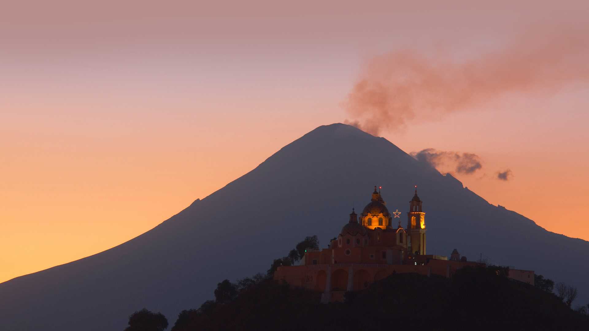
普埃布拉天主堂和波波卡特佩特火山,普埃布拉,墨西哥 Church of Nuestra Señora de los Remedios and Popocatépetl, Puebla, Mexico (© Radius Images/Shutterstock)
从胜利到欢庆 From victory to festivity
普埃布拉,墨西哥
与许多人的看法相反,5月5日并不是墨西哥的独立日。
真正的墨西哥独立日是在每年的9月16日庆祝。
而5月5日是为了庆祝在1862年的这一天墨西哥在普埃布拉战役中战胜法兰西帝国。虽然这一天是为了纪念一个重大的历史事件,但墨西哥的庆祝活动相对平静,主要集中在普埃布拉。
在墨西哥,这一天被称为“普埃布拉战役日”,因为当时的墨西哥总统贝尼托·巴勃罗·胡亚雷斯·加尔卡
(Benito Pablo Juárez Garca) 于 1862
年宣布这一节日为国定假日。今天,普埃布拉人民通过游行、演讲和战斗重演来庆祝。图中的 普埃布拉天主堂又称济世圣母教堂(Nuestra Señora
de los Remedios )在普埃布拉战役爆发时已经有将近 300 年的历史。
Cinco de Mayo
Contrary to what many people believe, Cinco de Mayo is not Mexico's Independence Day, which is celebrated on September 16. Instead, May 5 marks Mexico's victory over better-equipped French forces at the Battle of Puebla on May 5, 1862. Although the French Empire would counterattack and take the city a year later, the unexpected victory was a morale boost which still has symbolic significance. While in the US, Cinco de Mayo is a popular festival celebrating Mexican American culture, celebrations in Mexico are relatively quiet and focused mostly on Puebla.
In Mexico, the celebration became known as Battle of Puebla Day after President Benito Juárez declared it a national holiday in 1862. Today, the people of Puebla celebrate with parades, speeches, and battle reenactments. The Church of Nuestra Señora de los Remedios in Puebla, pictured here, was already nearly 300 years old when the 1862 battle was fought. And human history is just the blink of an eye to ancient Popocatépetl, the smoking volcano which towers over Puebla in the background of our homepage image.
爪哇岛东部的婆罗摩火山,印度尼西亚 Mount Bromo in East Java, Indonesia (© Bento Fotography/Getty Images)
爪哇岛东部的婆罗摩火山,印度尼西亚 Mount Bromo in East Java, Indonesia (© Bento Fotography/Getty Images)
这座缥缈的山在哪里? Where is this ethereal mountain?
婆罗摩火山,爪哇岛东部,印度尼西亚
婆罗摩火山是一座活跃的索玛火山,海拔约2393米,位于婆罗摩腾格里国家公园内,这里风景优美,日出景观尤为壮丽,是印度尼西亚爪哇岛东部最具标志性的景点之一。其名字来源于爪哇语“梵天”的发音,梵天是印度教的创造之神。
婆罗摩火山是腾格尔火山口中唯一的活火山,周围铺满细细的火山沙,宛如沙海。过去的二十年里,这座火山已经爆发了四次。
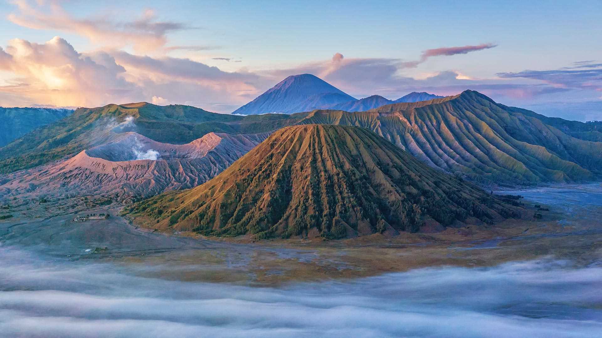
Bromo Tengger Semeru National Park, East Java, Indonesia
Welcome to the spectacular Bromo Tengger Semeru National Park, on the Indonesian island of Java, famous for stunning sunrises and its dramatic landscape. Here, a massive ancient volcano erupted thousands of years ago and inside its collapsed crater, more volcanoes formed.
To the left, spewing smoke and steam, is Mount Bromo, one of the most iconic sites in East Java, which has erupted at least four times in the last 20 years. In the forefront of the picture, with trees creeping up the sides, is Mount Batok, which is no longer active, while Java's highest mountain (and active volcano) Semeru, is visible in the background. The Tengger Sand Sea, a vast area of fine volcanic sand, wraps around five volcanoes inside the caldera. No wonder this massive national park is sometimes referred to as the land of sand and fire.
圣海伦斯山国家火山纪念区的边界小径,美国华盛顿州 Boundary Trail in Mount St. Helens National Volcanic Monument, Washington (© Don Geyer/Alamy)
圣海伦斯山国家火山纪念区的边界小径,美国华盛顿州 Boundary Trail in Mount St. Helens National Volcanic Monument, Washington (© Don Geyer/Alamy)
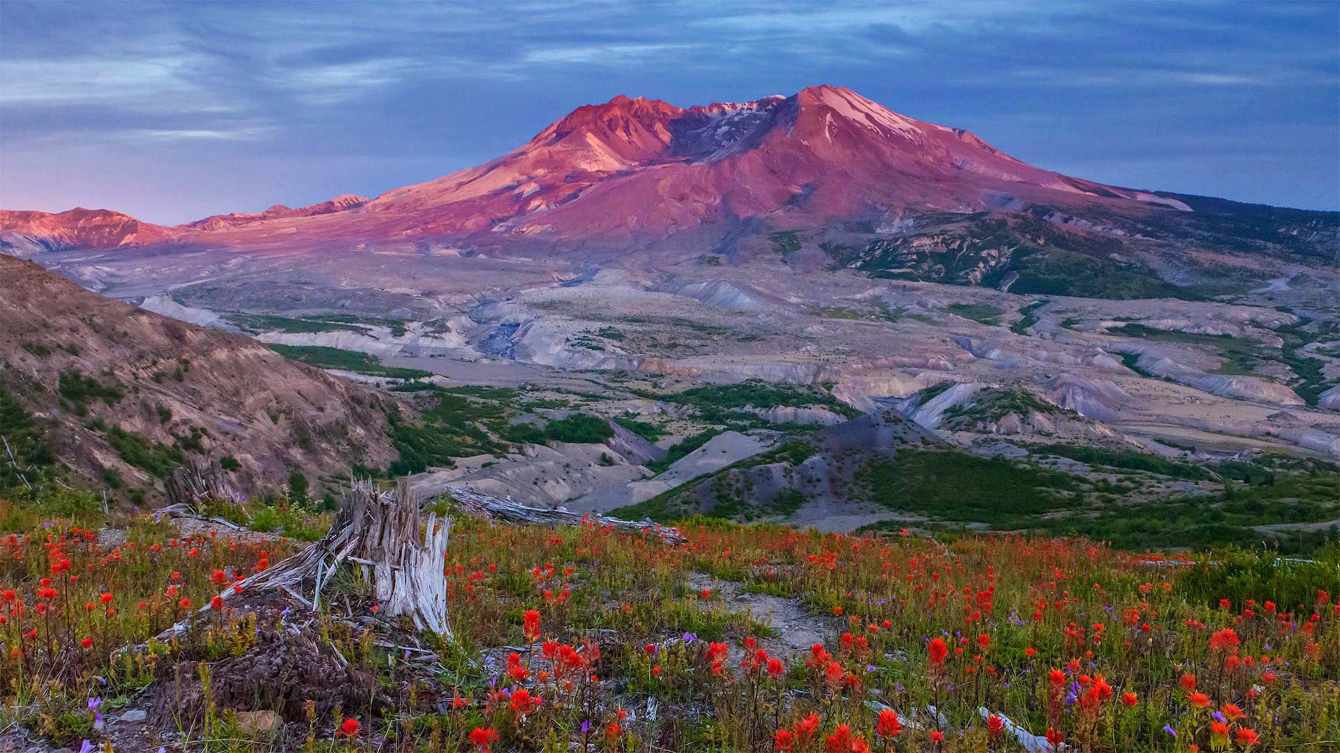
40年的休养生息 40 years of recovery
Mount St. Helens National Volcanic Monument, Washington
Today is an important day in American history. We're standing on the Boundary Trail at Johnston Ridge in the Mount St. Helens National Volcanic Monument. Forty years ago today, 110,000 acres within Gifford Pinchot National Forest was set aside to memorialize the deadliest and most destructive volcanic eruption in the United States. For nearly nine hours on May 18th, 1980, the Mount St. Helens erupted, forever changing the Washington landscape. The volcanic event started at roughly 8:30 on a Sunday morning with a 5.1 magnitude earthquake. This triggered what is known as a 'lateral eruption,' which means the lava blast comes out of the side of the volcano, rather than the top. The initial blast shaved more than a thousand feet off the mountain's elevation, resulting in a massive avalanche and the destruction of about 150 square miles of the surrounding forest. When the event ended, 57 people had died, 200 homes and almost 200 miles of nearby highway had been destroyed.
The monument was established by President Ronald Reagan in 1982 to preserve the area for research, recreation, and education. The land inside has been left to mostly recover naturally since the eruption. While it's believed that Mount St. Helens will erupt again sometime within the next few centuries, that has not deterred people from hiking and climbing at the monument, which has been allowed since 1986.
圣海伦山国家火山纪念碑,华盛顿
今天是美国历史上重要的一天。我们站在圣海伦斯山国家火山纪念碑的约翰斯顿山脊的边界小道上。四十年前的今天,吉福-平肖国家森林内的110000英亩土地被用来纪念美国最致命、破坏性最大的火山爆发。1980年5月18日,圣海伦斯山爆发了近9个小时,永远改变了华盛顿的景观。火山爆发于周日早上8点30分左右,发生了5.1级地震。这引发了所谓的“侧向喷发”,这意味着熔岩喷发从火山的侧面而不是顶部。最初的爆炸使山的海拔下降了一千多英尺,导致了一场大规模的雪崩,并摧毁了周围约150平方英里的森林。活动结束时,57人死亡,200所房屋和近200英里的附近公路被毁。
该纪念碑由罗纳德·里根总统于1982年建立,旨在保护该地区的研究、娱乐和教育。火山爆发后,火山内部的土地基本上自然恢复。虽然人们相信圣海伦斯山将在未来几个世纪的某个时候再次喷发,但这并没有阻止人们前往这座自1986年以来就被允许的纪念碑进行徒步旅行和攀登。
漏出“天窗”的熔岩管,夏威夷火山国家公园 Skylight into an active lava tube, Hawaii Volcanoes National Park, Hawaii (© Tom Schwabel/Tandem Stills + Motion)
漏出“天窗”的熔岩管,夏威夷火山国家公园 Skylight into an active lava tube, Hawaii Volcanoes National Park, Hawaii (© Tom Schwabel/Tandem Stills + Motion)
世界上最活跃的火山 The most active volcano in the world
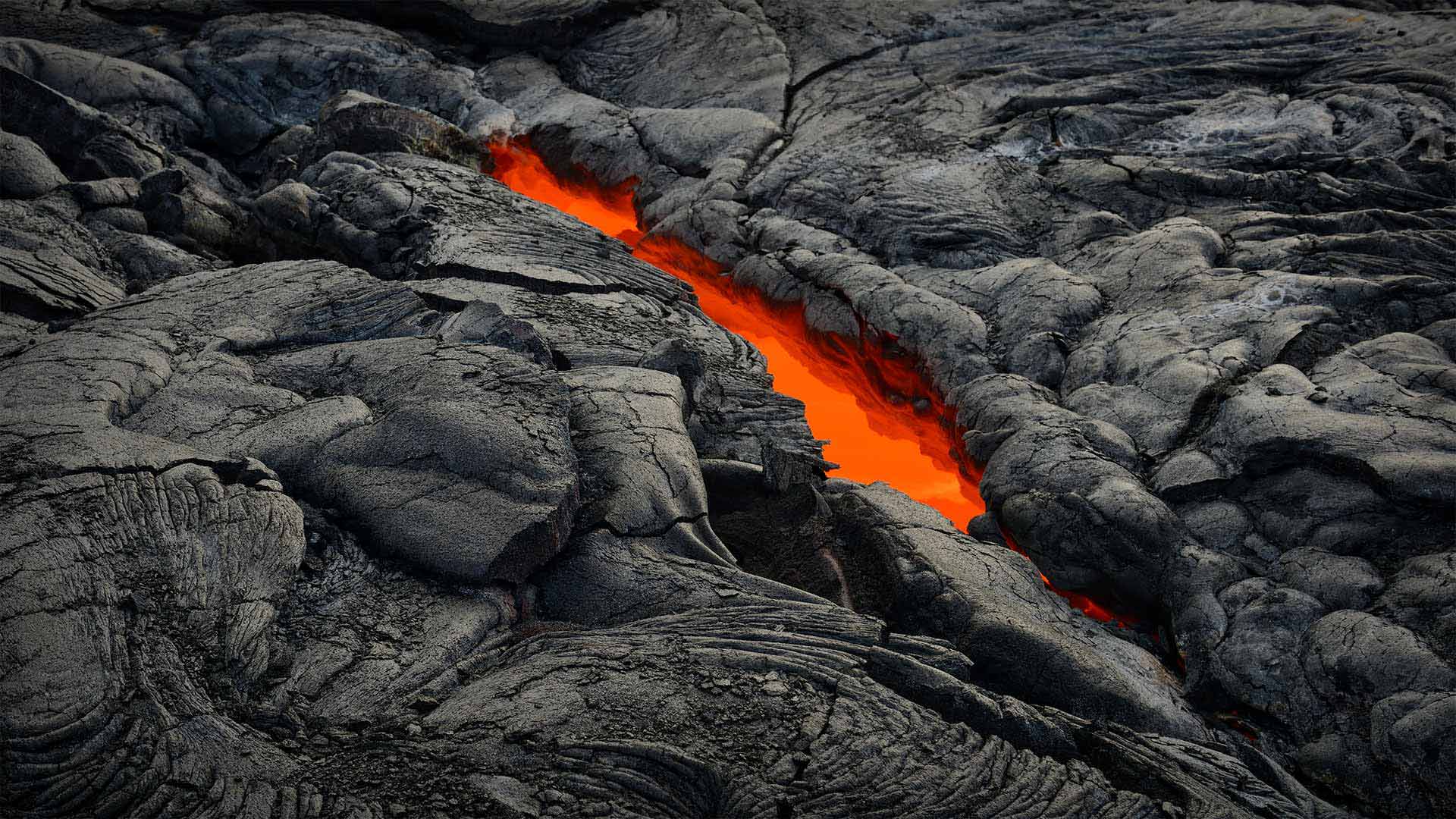
Hawai'i Volcanoes National Park at 106
The orange glow of a lava tube like the one pictured here is a frequent site on Hawaii's Kilauea, the youngest volcano on one of the youngest islands on Earth. In near constant eruption for the last 40 years, Kilauea is widely considered the most active volcano in the world and is the main attraction at Hawaii Volcanoes National Park, which was created on this day in 1916. The park, which was designated an International Biosphere Reserve and a World Heritage Site, also includes another active volcano, Mauna Loa, the world's most massive shield volcano—Mauna Loa last erupted in 1984. Together, they are among the most studied volcanoes in the world.
The volcanoes of the Big Island of Hawaii offer a real-time glimpse into the ongoing creation of the entire Hawaiian island chain, a process that has been underway for tens of millions of years. Hawaii as we know it owes its existence to a volcanic hotspot on the seafloor. Magma seeps from this hotspot and turns into solid rock. Once enough magma is extruded, the rock breaks the surface of the sea and becomes an island. The island continues to grow until the Pacific tectonic plate moves the island off the hotspot. The hotspot remains stationary, constantly creating new islands. In fact, the next Hawaiian island, named Loihi, is about 20 miles from Hawaii and 3,000 feet below the surface of the ocean. In less than 100,000 years, it is expected to replace the Big Island as the youngest island in the chain, and it too will have its turn at hosting visitors who buy timeshare condos.
Hawaiian religion credits the creation of Hawaii to Pele, the goddess of fire and volcanoes. Possessing a fiery temper and a passionate nature, she is said to make her home in the Halema'uma'u caldera here on Kilauea. From her volcano home she controls the flow of lava and frequency of eruptions. According to modern legend, she sometimes wanders near the park as an old woman wearing a red muumuu, with a white dog, as a warning that a new eruption is soon to come.
106号夏威夷火山国家公园
图中所示的橙色熔岩管辉光是夏威夷基拉韦厄岛上的一个常见地点,基拉韦耶岛是地球上最年轻岛屿之一上最年轻的火山。在过去40年中,基拉韦厄火山几乎持续喷发,被广泛认为是世界上最活跃的火山,是1916年创建的夏威夷火山国家公园的主要景点。该公园被指定为国际生物圈保护区和世界遗产,还包括另一座活火山,莫纳罗亚,世界上最大的盾状火山莫纳洛上次喷发是在1984年。加在一起,它们是世界上研究最多的火山之一。
夏威夷大岛上的火山可以实时观察整个夏威夷岛链的形成过程,这一过程已经持续了数千万年。众所周知,夏威夷的存在得益于海底的火山热点。岩浆从这个热点渗出,变成固体岩石。一旦足够的岩浆被挤出,岩石就会冲破海面,变成一个岛屿。该岛继续增长,直到太平洋构造板块将该岛移出热点。热点保持静止,不断形成新的岛屿。事实上,下一个夏威夷岛,名为Loihi,距离夏威夷约20英里,海拔3000英尺。预计在不到10万年的时间里,它将取代大岛,成为这一链条中最年轻的岛屿,轮到它接待购买分时度假公寓的游客。
夏威夷宗教将夏威夷的诞生归功于火与火山女神贝利。她脾气暴躁,生性热情,据说住在基拉韦厄岛的Halema'uma'u火山口。她在火山口的家中控制着熔岩的流动和喷发的频率。根据现代传说,她有时会在公园附近漫步,就像一个穿着红色muumuu的老妇人,带着一只白色的狗,作为新火山爆发即将到来的警告。
菲律宾马荣山的火山口冒烟 Crater glow from Mount Mayon in the Philippines (© Per-Andre Hoffmann/Cavan)
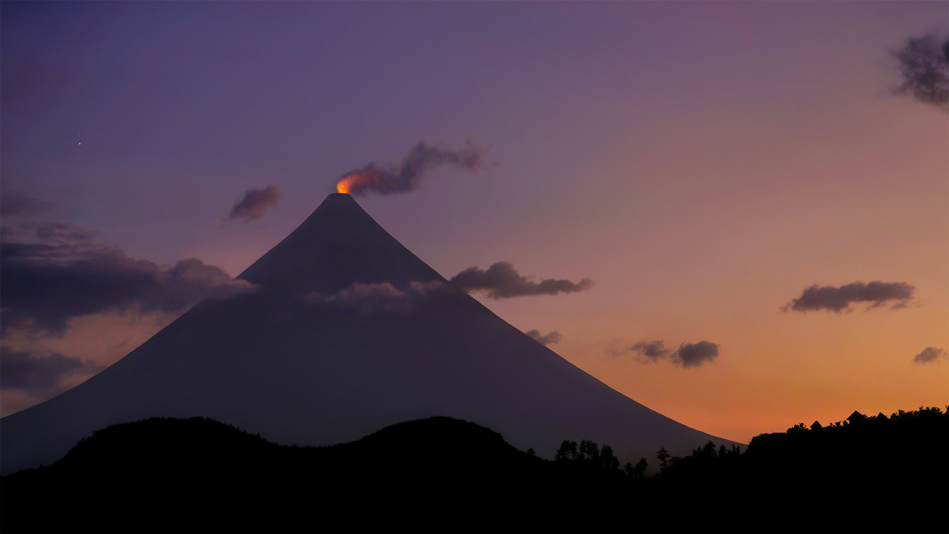
菲律宾马荣山的火山口冒烟 Crater glow from Mount Mayon in the Philippines (© Per-Andre Hoffmann/Cavan)
Behold the 'perfect' cone
How far would you have to travel for the 'perfect cone'? Well, probably not too far if you're talking ice cream. But if volcanoes are what you're looking for, you'll have to make your way to Mount Mayon on the Philippine island of Luzon. The glowing lava you see is on the tip of the world's most perfectly shaped, symmetrical volcanic cone, which formed after years of eruptions from what is still an active stratovolcano. Mount Mayon has erupted dozens of times in the past 400 years, and there was a significant eruption as recently as 2018. Even this year, smaller white steam plume emissions and faint crater glow are sometimes visible. Mayon is the most active volcano in an island nation full of active volcanos, and is located inside the UNESCO Albay Biosphere Reserve, as well as the Philippine's Mayon Volcano Natural Park. Despite its active status, tourists still flock to the park to view the unique beauty of this cone shaped spectacle.
请看“完美”圆锥体
为了“完美的圆锥体”,你需要走多远?嗯,如果你说的是冰淇淋,可能不会太远。但是如果你要找的是火山,你就得去菲律宾吕宋岛上的马荣山。你所看到的炽热的熔岩位于世界上形状最完美、对称的火山锥的顶端,这座火山锥是在多年的喷发后形成的,它仍然是一座活跃的层火山。在过去的400年中,马荣山已经喷发了几十次,最近在2018年发生了一次重大喷发。即使在今年,也可以看到较小的白色蒸汽羽流排放和微弱的火山口辉光。马荣火山位于联合国教科文组织阿尔拜生物圈保护区以及菲律宾的马荣火山自然公园内,是一个充满活火山的岛国中最活跃的火山。尽管公园处于活跃状态,游客仍然蜂拥而至,欣赏这一锥形景观的独特之美。
死亡谷国家公园里的优比喜比火山口,加利福尼亚州 Ubehebe Crater in Death Valley National Park, California (© Albert Knapp/Alamy)
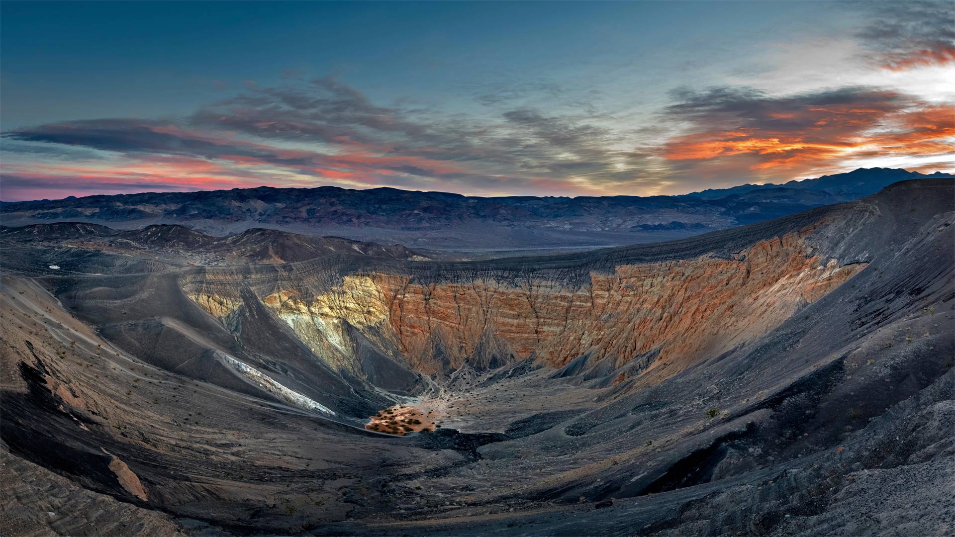
死亡谷国家公园里的优比喜比火山口,加利福尼亚州 Ubehebe Crater in Death Valley National Park, California (© Albert Knapp/Alamy)
When Death Valley blew its top
Deep below Death Valley's charred surface, blazing hot magma once gushed up through a geologic fault until it hit groundwater. The magma quickly turned the water to steam, and like a defective subterranean pressure cooker, the Earth's crust blew its top in a ferocious explosion. The hydrovolcanic eruption sent up a mushroom cloud of steam and spewed burnt volcanic cinders for miles. It also left the giant crater seen in this photo and 12 smaller ones spread across the surface.
The Ubehebe Crater (pronounced you-bee-HEE-bee) is a half-mile across and more than 700 feet deep. Geologically speaking, Ubehebe and the other craters here are quite young. A 2016 study concluded that the craters were all formed in a relatively brief series of explosions—a period of days or weeks—about 2,100 years ago. Another eruption could happen, but visitors need not worry about the ground below their feet—seismometers in the region will alert geologists in advance of any future volcanic unrest. A trail around the rim of the crater offers views of the colorful layers of stone along the walls. Adventurous hikers can descend to the bottom, but it's a long slog back out again, especially on a sweltering summer day.
当死亡谷爆发时
在死亡谷烧焦的地表深处,炽热的岩浆曾经通过地质断层喷涌而出,直到触及地下水。岩浆很快将水变成蒸汽,就像一个有缺陷的地下压力锅,地壳在猛烈的爆炸中炸开了顶部。水火山喷发喷出蘑菇状的蒸汽云,喷出燃烧的火山灰数英里。它还留下了这张照片中看到的巨大陨石坑,12个较小的陨石坑散布在地表。
Ubehebe火山口(发音为you bee HEE bee)宽半英里,深700多英尺。从地质学的角度来说,乌贝赫比和这里的其他陨石坑都很年轻。2016年的一项研究得出结论,这些陨石坑都是在相对短暂的一系列爆炸中形成的——大约2100年前的几天或几周时间。另一次火山喷发可能会发生,但游客不必担心脚下的地面。该地区的地震仪将在未来的火山动荡之前提醒地质学家。沿着火山口边缘的小径可以看到沿着墙壁的彩色石层。喜欢冒险的徒步旅行者可以爬到水底,但要想再次爬出来还需要很长时间,尤其是在炎热的夏天。