标签 沙漠 下的文章
春天盛开的沙漠毒菊,索诺拉沙漠,亚利桑那州 Brittlebushes blooming in springtime, Sonoran Desert, Arizona (© Charles Harker/Getty Images)
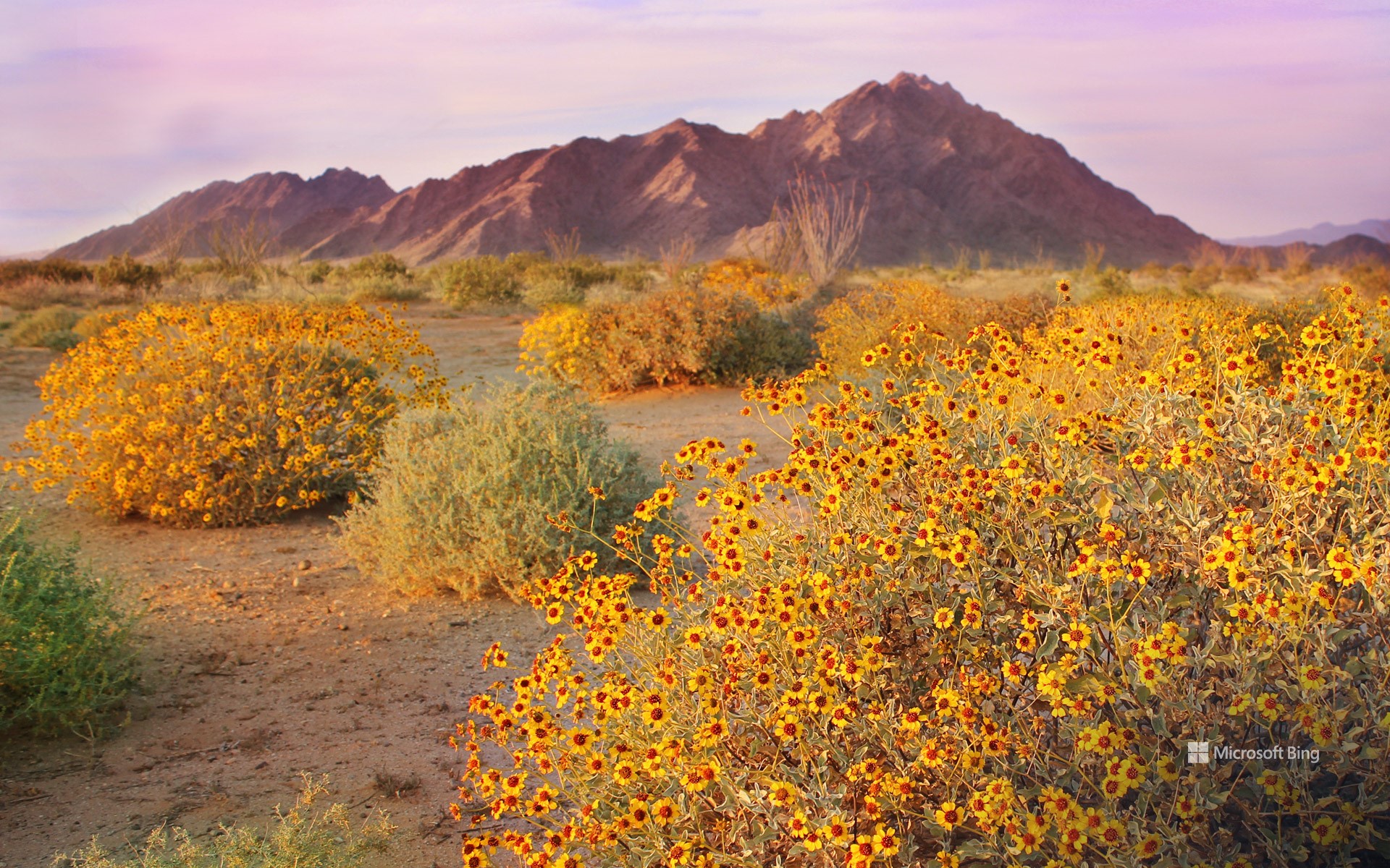
春天盛开的沙漠毒菊,索诺拉沙漠,亚利桑那州 Brittlebushes blooming in springtime, Sonoran Desert, Arizona (© Charles Harker/Getty Images)
最热的地方也有凉爽之处 Even the hottest places are cool!
索诺拉沙漠,亚利桑那州
当温暖的阳光照在你身上时,你就知道自己来到了亚利桑那州的索诺拉沙漠!在这片干旱的土地上,生活着各种动物,如走鹃、吉拉毒蜥和沙漠乌龟。索诺拉沙漠有两个雨季,因此会有五颜六色的野花盛开,图中的沙漠毒菊就是其中之一。这些耐寒的灌木适应了干燥的气候,银灰色的叶子上覆盖着细毛,有助于减少蒸腾作用导致的水分流失。沙漠毒菊开出鲜艳的黄色花朵,一簇簇地挂在枝头,为沙漠增添了一抹亮色。另一种耐旱的沙漠植物是名为巨人柱的仙人掌,它可以活150多年,长到40英尺高。这些仙人掌为沙漠物种提供食物和栖息地。在托霍诺奥德姆人的文化中,仙人掌也是一种神圣的植物,可以用来满足生活需求和举行宗教仪式。
The Sonoran Desert, Arizona
Welcome to the Sonoran Desert, where life thrives despite the heat thanks to two seasons of rainfall. This subtropical desert spreads across parts of Mexico, California, and Arizona and is home to animals such as roadrunners, Gila monsters, and the Morafka's desert tortoise. Its rainy seasons are followed by the blossoming of colorful wildflowers such as the brittlebush, seen in today's image. These hardy shrubs are adapted to the dry seasons, with their silvery-gray leaves covered in fine hairs that help reduce water loss. Brittlebushes produce bright yellow flowers that bloom in clusters, adding splashes of color to the desert landscape. Another drought-loving desert flora is the saguaro cactus, which can live for over 150 years and grow up to 40 feet tall. The saguaro also provides food and shelter for desert species and is a sacred plant in the culture of the Tohono O'odham people.
安沙波利哥沙漠州立公园,美国加利福尼亚州 Anza-Borrego Desert State Park, California (© Stephen Matera/Tandem Stills + Motion)
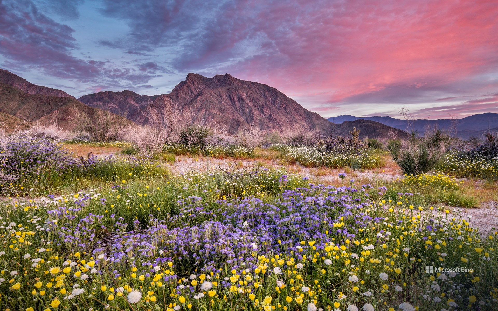
安沙波利哥沙漠州立公园,美国加利福尼亚州 Anza-Borrego Desert State Park, California (© Stephen Matera/Tandem Stills + Motion)
一抹春色 Where is this colorful desert?
安沙波利哥沙漠州立公园,美国加利福尼亚州
也许距离春天伊始还有好些天,但是加州最大的州立公园——安沙波利哥沙漠州立公园的野花已经在这里向你问好了!每年春天,这片贫瘠的沙漠都会经历一次戏剧性的改变。向日葵、沙漠菊和蒲公英等花朵竞相绽放,形成色彩斑斓的奇观。对于那些想要寻求更多冒险体验的游客来说,从半岛山脉仙人掌丛生的丘陵到峡谷、荒地和天然棕榈绿洲,这个公园有很多可供选择的地方。此外,作为指定的国际黑暗天空公园,这里还是绝佳的观星地点。除了自然奇观之外,占地超过60万英亩的公园还拥有丰富的文化和历史遗产,如古老的象形文字或岩画。
Anza-Borrego Desert State Park, California
The first day of spring may be just days away, but the season's wildflowers at California's largest state park—Anza-Borrego Desert State Park—are already here to say hello! Every spring, this barren desert floor undergoes a dramatic makeover. Flowers like heliotrope, brittlebush, and desert dandelion burst into a riot of bloom, creating a spectacle of color. For those seeking a more adventurous experience, this park has a lot to offer—from the mountains of the Peninsular Ranges and cactus-studded hills to slot canyons, badlands, and natural palm oases. In addition, as a designated International Dark Sky Park, it is an exceptional spot for stargazing. Beyond its natural wonders, the park, spanning over 600,000 acres, is also home to a rich cultural and historical legacy, including ancient pictographs, or rock paintings, from the Native American tribes that once lived here.
撒哈拉沙漠一组沙丘上最后的阳光, 阿尔及利亚 Last rays of sun on a group of dunes, Sahara, Algeria (© AWL Images/DanitaDelimont.com)
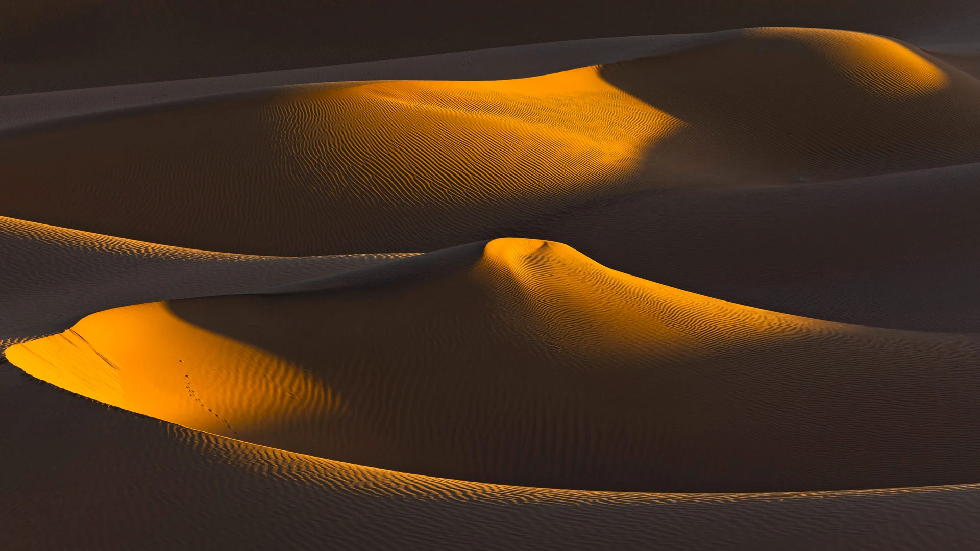
撒哈拉沙漠一组沙丘上最后的阳光, 阿尔及利亚 Last rays of sun on a group of dunes, Sahara, Algeria (© AWL Images/DanitaDelimont.com)
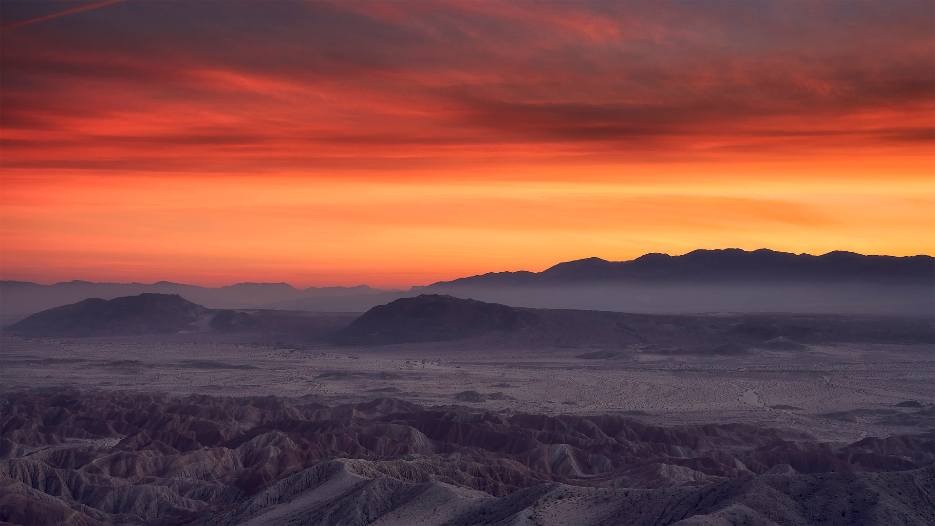
每天都有不同的沙丘 Each day a different dune
阿尔及利亚撒哈拉沙漠的沙丘
撒哈拉沙漠横跨北非300多万平方英里,覆盖阿尔及利亚、埃及、摩洛哥、苏丹和突尼斯等国的大部分地区。巨大的沙丘、岩石高原和偶尔出现的绿洲创造了独一无二的景观。尽管撒哈拉是世界上最大的热带沙漠,但它支持阿拉伯树胶和棕榈树等耐旱植物,以及骆驼和狐狸等耐寒动物。有趣的特征包括其不断变化的沙丘,如今天的图片所示,其中一些沙丘超过500英尺高。这里还发现了古代岩石艺术和化石,为早期文明和史前生物提供了见解。沙尘暴很常见,它塑造了千变万化的风景,也增加了这一自然奇观的神秘感。
Sand dunes in the Sahara, Algeria
The Sahara spans over 3 million square miles of North Africa, covering large parts of various countries including Algeria, Egypt, Morocco, Sudan, and Tunisia. Vast sand dunes, rocky plateaus, and occasional oases create a landscape like no other. Although it is the largest hot desert in the world, the Sahara supports drought-resistant plants like acacia and palm trees, and hardy animals such as camels and fennec foxes. Intriguing features include its shifting sand dunes, pictured in today's image, some of which are over 500 feet high. Ancient rock art and fossils have also been discovered here, providing insights into early civilizations and prehistoric creatures. Sandstorms are common, shaping the ever-changing scenery and adding to the mystique of this natural wonder.
沙漠中的骆驼,阿拉伯联合酋长国 Camels in the desert, United Arab Emirates (© Amazing Aerial Premium/Shutterstock)
沙漠中的骆驼,阿拉伯联合酋长国 Camels in the desert, United Arab Emirates (© Amazing Aerial Premium/Shutterstock)
沙漠之舟 Ships of the desert, ahoy!
沙漠中的骆驼,阿拉伯联合酋长国
对于阿联酋人来说,沙漠中的骆驼长久以来都是至关紧要的,同时也代表着阿联酋人的文化遗产和习俗。骆驼是贝都因人运输水和物资的关键交通工具,对于穿越炙热的沙漠来说是必不可少的。这些单峰骆驼还曾经被作为货币使用,例如支付嫁妆或者天课(穆斯林每年的慈善课税)。它们还可以提供营养,骆驼奶在很多食谱中都是宝贵且营养的食材。最后,骆驼还可以供人驾骑、提供娱乐。由此可见,这些坚韧的动物实在是用途广泛。
Camels in the desert, United Arab Emirates
Desert-dwelling
camels have been central to lives in the United Arab Emirates for
thousands of years. A key mode of transportation for Bedouins, camels
long helped them traverse the sweltering sands in search of water and
supplies. These dromedaries were also used as currency to fulfill
obligations such as dowries or zakat, an annual charitable fee in Muslim
communities. Camel milk is a valuable and nutritious ingredient in many
recipes in the region, while camel racing keeps people entertained to
this day, illustrating the versatility of these hardy creatures.
塞多纳,亚利桑那州,美国 Sedona, Arizona (© Jonathan Ross/Getty Images)
塞多纳,亚利桑那州,美国 Sedona, Arizona (© Jonathan Ross/Getty Images)
红石的土地 Red rock country
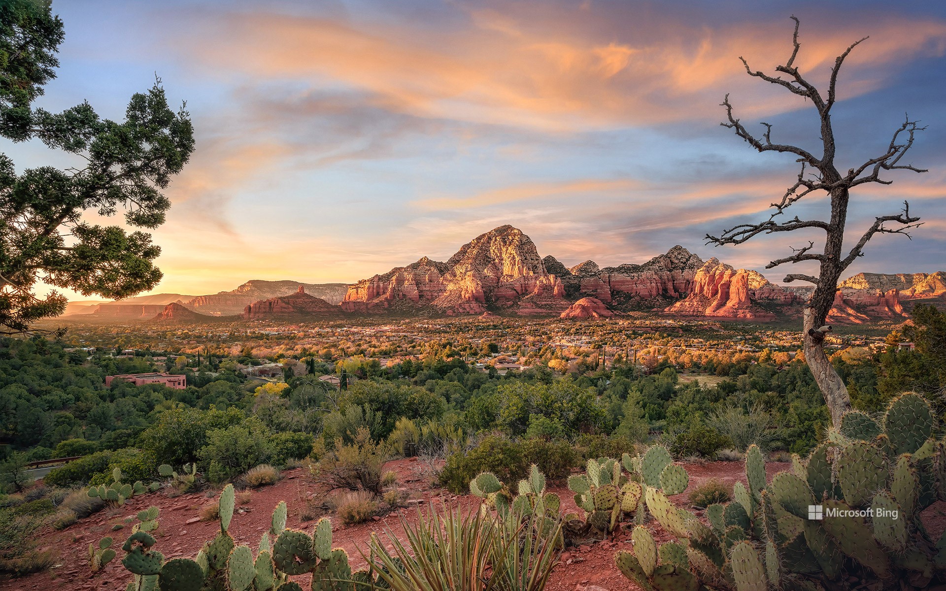
塞多纳,亚利桑那州,美国
从你踏入塞多纳的那一刻起,你将会震撼于其绝妙的景色和从沙漠中突兀而出的红色砂石悬崖。冒险爱好者热爱这里的美景和宁静。塞多纳还遍地是美洲原住民的历史。尽管由于缺少文字记述,我们对于这个地区最早的定居者知之甚少,他们被称为“祖先普韦布洛人”。普遍认为他们在1400年前在此定居。大部分有关这些古代先民的信息来自于考古遗迹和文物,包括大规模的普韦布洛人定居点遗址。
Sedona, Arizona
Stunning sandstone cliffs rise from the desert floor amid spectacular scenery here in Sedona, Arizona, also known as Red Rock Country. Adventure enthusiasts come to enjoy the beautiful trails that dot the region, which is also steeped in Native American history. The earliest settlers are believed to have been the Ancestral Puebloans, who inhabited the area around 1,400 years ago. Without any written history, most of the information about these ancient people comes from the archaeological ruins that remain, including cliff dwellings built under overhangs in the area's red sandstone rocks. Other Native American groups came to the area such as the Hakataya, the Hohokam, the Sinagua, and the modern-day tribes that live in Arizona today, the Tonto Apache and the Yavapai.
安沙波利哥沙漠州立公园的野花,加利福尼亚州,美国 Wildflowers in Anza-Borrego Desert State Park, California (© Ron and Patty Thomas/Getty Images)
安沙波利哥沙漠州立公园的野花,加利福尼亚州,美国 Wildflowers in Anza-Borrego Desert State Park, California (© Ron and Patty Thomas/Getty Images)
大自然最为色彩鲜艳的一面 Nature at its colorful best
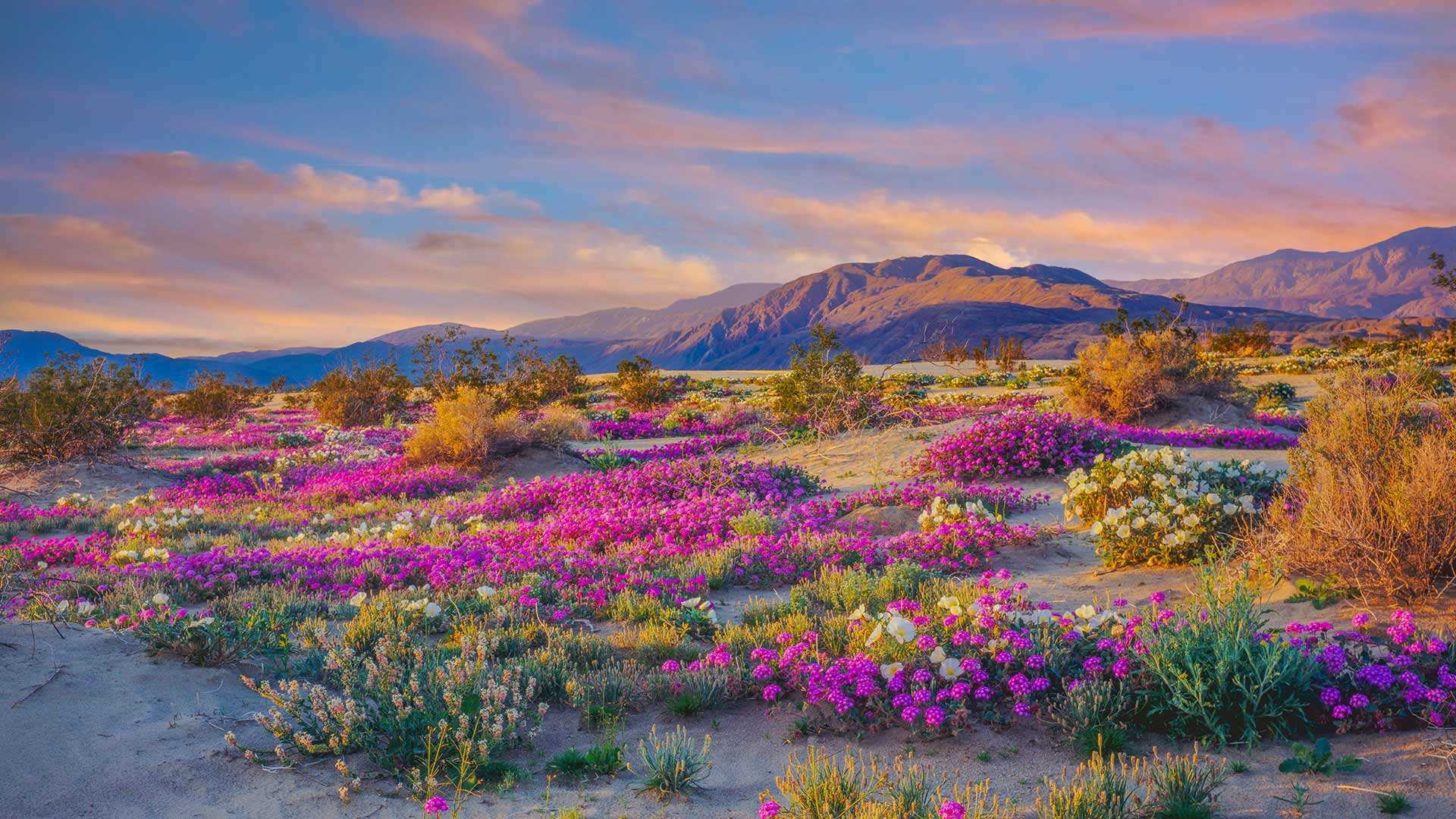
安沙波利哥沙漠州立公园,加利福尼亚州,美国
欢迎来到美国加州最大的沙漠州立公园——安沙波利哥。这个公园以烂漫春花和自然奇观而闻名。初夏是游览的最佳时节,漫山遍野都是各种野花、植物和仙人掌。这些野花为原本贫瘠的沙漠景观增添了色彩,吸引大批游客的到来。尽管你可能会想摘一些回家,但野花受到加州法律的保护,再说美景也不应私藏,而应大家共赏。
Anza-Borrego Desert State Park, California
Welcome to the largest state park in the golden state of California, Anza-Borrego. Located about 100 miles northeast of San Diego, the park is well known for its spectacular springtime wildflowers, stunning landscapes, and natural marvels. Spring and early summer are the best times to visit. That's when you'll find a myriad of magnificent, blooming species of flowers, including dune primrose, desert sunflowers, and desert sand verbena. These hardy wildflowers can survive in extreme heat and with little water–perfect for California's driest state park, in which some areas get just 2 inches of rain a year.
Heavier rains than usual brought a rare 'winter bloom' of wildflowers to Anza-Borrego earlier this year. And record-breaking rainstorms have continued, ensuring an excellent spring display. The wildflowers draw large crowds of tourists to the area. Though you might be tempted to take some home, the wildflowers are protected by state law and should be left for everyone to enjoy.
白沙国家公园,美国新墨西哥州 White Sands National Park, New Mexico (© Andrea Harrell/Tandem Stills + Motion)
白沙国家公园,美国新墨西哥州 White Sands National Park, New Mexico (© Andrea Harrell/Tandem Stills + Motion)
世界最大的石膏沙漠 The largest gypsum dune field
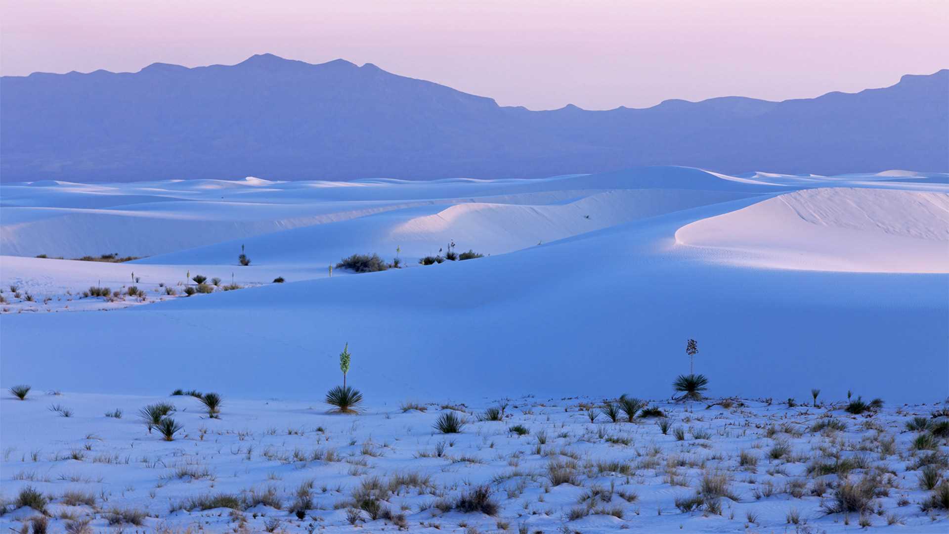
白沙国家公园,美国新墨西哥州
今天的照片是否让你感觉到一丝寒冷?其实这不是雪,而是地球上最大的石膏沙漠。这是位于新墨西哥州的白沙国家公园,在过去的1.2万年里,周围的山脉产生了约45亿吨雪白的石膏沙。这里最初于1933年1月18日被指定为白沙国家纪念地,然后在2019年正式成为白沙国家公园。如今,这座国家公园里生活着成千上万的物种,其中许多物种已经逐渐进化出了白色,以便更好融入环境。
White Sands National Park turns 90
If today's photo evokes some chilly feelings inside of you, surprise! That's not snow, but part of the largest gypsum dune field on the planet. We're at White Sands National Park in New Mexico, which was first established as a monument on this date in 1933 and then became a national park in 2019. Roughly 4.5 billion tons of gypsum sand has massed in the Tularosa Basin over the past 12,000 years, having worn off the surrounding mountains. Thousands of species live in the park, many of which have evolved to have white coloration, allowing them to blend into the environment.
白沙漠中的岩石,埃及 Rock formations in the White Desert, Egypt (© Anton Petrus/Getty Images)
白沙漠中的岩石,埃及 Rock formations in the White Desert, Egypt (© Anton Petrus/Getty Images)
这些雪永远不会融化 This snow will never melt
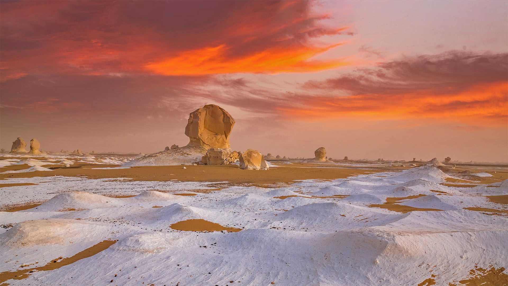
白沙漠国家公园,埃及
这是沙漠中的雪吗?其实不是。这里是埃及的白沙漠,当地丰富的白垩岩、石灰岩、石英岩以及长年累月的风化作用造就了这些白色的沙子和形状奇特的岩石,白沙漠也因此得名。游客们蜂拥而至,来欣赏这些大自然的奇观。白沙国家公园距离开罗约5小时车程,这里不仅有白沙和怪石,还有多种濒危保护动物。
White Desert National Park, Egypt
Snow, in the desert? Not quite. Today we're in Egypt's White Desert, which gets its colorful name from an abundance of chalk, limestone, and quartz rock formations that give the sand its special hue. Tourists flock to this place to see these naturally occurring structures, honed over thousands of years into unique shapes through a process known as 'differential weathering.' Located about five hours to the southwest of Cairo, White Desert National Park is a lot more than just deteriorating rocks—it's also a protected refuge for several endangered animal species.
安沙波利哥沙漠州立公园,美国加利福尼亚州 Borrego Badlands in Anza-Borrego Desert State Park, California (© Tom Hogan/plainpicture)
安沙波利哥沙漠州立公园,美国加利福尼亚州 Borrego Badlands in Anza-Borrego Desert State Park, California (© Tom Hogan/plainpicture)
Borrego Badlands
If you're looking to take in a beautiful sunset over some exotic terrain, you could do worse than the Borrego Badlands, a 20-mile stretch of desert in southeastern California's Anza-Borrego Desert State Park. This arid landscape is not the kind of dune-filled terrain t you might visualize when you think of a desert, but a series of rolling hills, canyons, gullies, and arroyos, speckled with sparse but hardy vegetation. It makes for a surreal and beautiful view.
Fossilized seashells found in the area reveal that this arid landscape was once submerged under the waters of the Gulf of California and the Colorado River. The terrain was shaped over time by water and wind erosion into its current form. Today, the Borrego Badlands is a favorite spot for campers, while photographers are drawn by the picture-perfect sunsets.
博雷戈荒地
如果你想在异国情调的地形上欣赏美丽的日落,你可能会比博雷戈荒地(Borrego Badlands)更糟糕。博雷戈荒地位于加利福尼亚州东南部的安扎博雷戈沙漠州立公园(Anza Borrego desert State Park),是一片20英里长的沙漠。这片干旱的土地并不是你想象中的那种布满沙丘的土地,而是一系列起伏的丘陵、峡谷、沟壑和荒野,点缀着稀疏但耐寒的植被。这是一个超现实主义和美丽的景色。
在该地区发现的贝壳化石表明,这片干旱的土地曾被淹没在加利福尼亚湾和科罗拉多河的水域之下。随着时间的推移,地形被水和风侵蚀成现在的形状。今天,博雷戈荒地是露营者最喜欢的地方,而摄影师则被完美的日落所吸引。
位于阿曼和迪拜酋长国边界的鲁卜哈利沙漠 Rub' al Khali desert on the border of Oman and the Emirate of Dubai (© Daniel Schoenen/Offset by Shutterstock)
位于阿曼和迪拜酋长国边界的鲁卜哈利沙漠 Rub' al Khali desert on the border of Oman and the Emirate of Dubai (© Daniel Schoenen/Offset by Shutterstock)
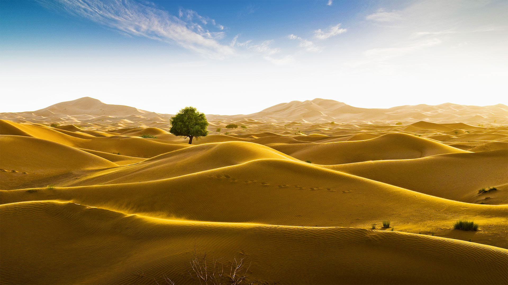
Signs of life in the 'Empty Quarter'
An unlikely tree stands amid the seemingly endless dunes of the Rub' al Khali desert in the Arabian Peninsula. The Rub' al Khali, meaning the 'Empty Quarter,' is a vast sea of sand. Spreading across 250,000 square miles, it's the largest contiguous sand desert in the world, covering most of southeastern Saudi Arabia, with smaller portions in Yemen, Oman, and the United Arab Emirates. One of the driest places on Earth, almost no one lives in Rub' al Khali, and much of the desert remains unexplored. Some of the dunes tower more than 800 feet, and the depressions in between—called sabkhas—can be so soft that vehicles, camels, and people can easily become stuck.
The Rub' al Khali wasn't always so forbiddingly dry. At various times between 2,000 and 6,000 years ago, 'cataclysmic rainfall,' like modern-day monsoons, formed shallow lakes in the spaces between the dunes. Most of these lakes were temporary, but some lasted hundreds of years and supported a variety of plants and animals, even large creatures like hippopotamuses, water buffalo, and long-horned cattle. Rain isn't unheard of today, either. In May 2018, Cyclone Mekunu brought enough rain to once again form lakes in the Rub' al Khali, reportedly the first time that had happened in about 20 years—it was the rare occasion when the 'Empty Quarter' wasn't looking so empty after all.
“空旷地区”的生命迹象
阿拉伯半岛的鲁布阿勒哈利沙漠看似无边无际的沙丘中矗立着一棵不太可能的树。“鲁布”阿勒哈利,意思是“空区”,是一片广阔的沙海。它横跨250000平方英里,是世界上最大的连片沙漠,覆盖沙特阿拉伯东南部大部分地区,也门、阿曼和阿拉伯联合酋长国的面积较小。作为地球上最干燥的地方之一,鲁巴勒哈利几乎无人居住,而大部分沙漠仍未被勘探。有些沙丘高达800英尺以上,中间的洼地称为沙布喀,非常柔软,车辆、骆驼和人很容易被卡住。
阿勒哈利河并不总是那么干燥。在2000年至6000年前的不同时期,“灾难性降雨”就像现代季风一样,在沙丘之间形成了浅湖。这些湖泊大多是临时性的,但也有一些持续了数百年,供养着各种动植物,甚至还有河马、水牛和长角牛等大型动物。今天下雨也并非闻所未闻。2018年5月,梅库努气旋带来了足够的雨水,再次在鲁布阿勒哈利形成湖泊,据报道这是大约20年来首次发生,这是罕见的“空旷区”看起来不再那么空旷的情况。