标签 新墨西哥 下的文章
比斯第恶土,新墨西哥州,美国 Bisti/De-Na-Zin Wilderness Area, New Mexico (© Ian Shive/Tandem Stills + Motion)
比斯第恶土,新墨西哥州,美国 Bisti/De-Na-Zin Wilderness Area, New Mexico (© Ian Shive/Tandem Stills + Motion)
因时间而改变 Transformed by time
新墨西哥州比斯第恶土
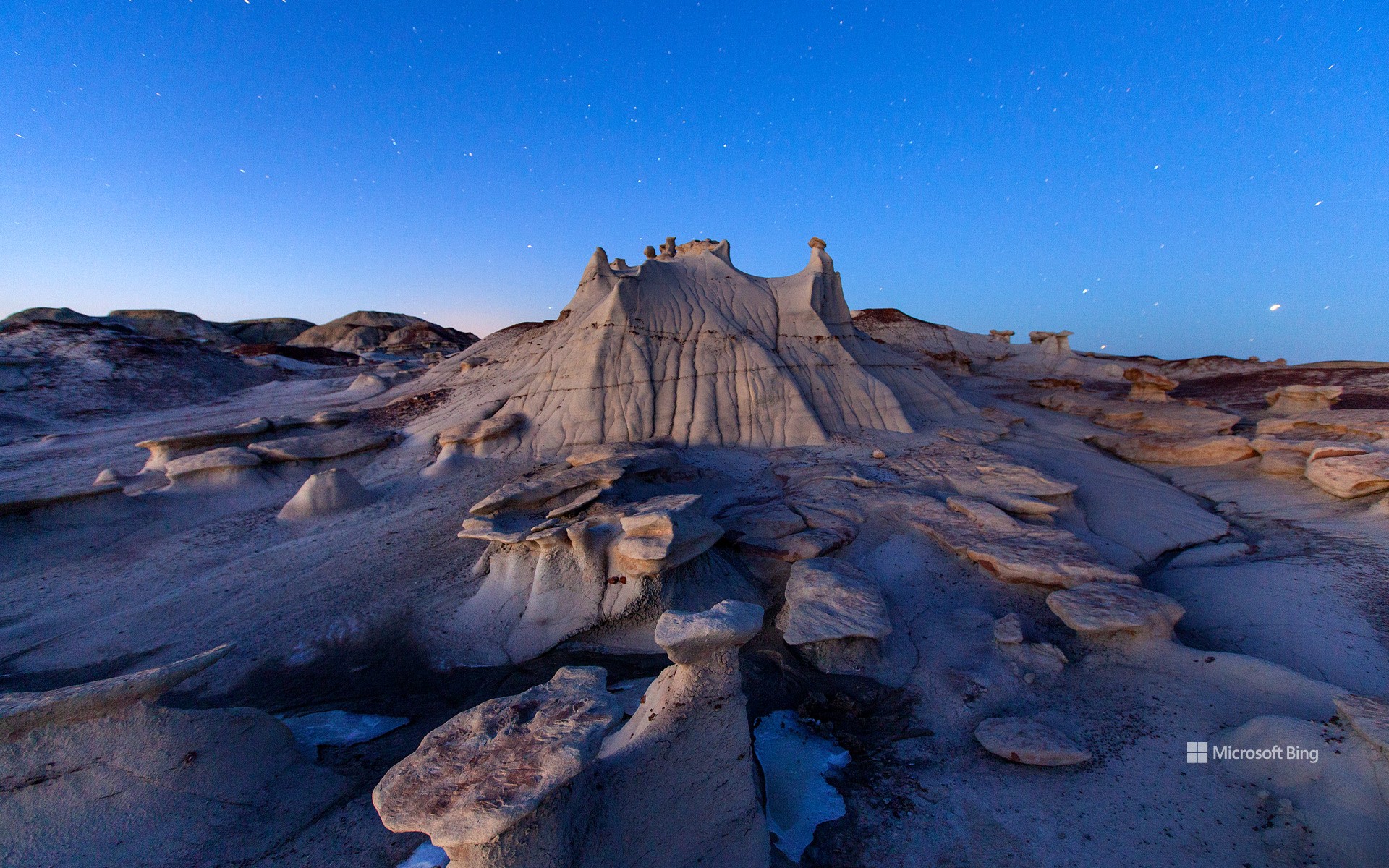
时间是伟大的变革者,它改变着世界,也改变着我们所有人。例如,新墨西哥州的这片名为比斯第恶土的荒地,曾经是一片郁郁葱葱的热带森林。近7000万年前,这里没有扭曲的地形和高耸的尖塔,而是一群白垩纪晚期恐龙的家园,包括甲龙、鸭嘴龙和强大的霸王龙。如今,这里到处都是另一种奇观,岩层看起来更像是雕塑,而不是自然现象。比斯第恶土的名字“Bisti/De-Na-Zin”是以纳瓦霍语命名的:“Bisti” 的意思是 "在土坯岩层中",“De-Na-Zin” 则来自附近的 "站立的仙起重机"石刻。来到四角地区的游客一定不要错过这片由页岩和砂岩组成的超凡脱俗的景观。
Bisti/De-Na-Zin Wilderness, New Mexico
Time is the great transformer, changing the world and all of us. For instance, this New Mexico badland—the Bisti/De-Na-Zin Wilderness—was once a lush, tropical forest. Nearly 70 million years ago, instead of twisted terrains and towering spires, this place was home to an array of Late Cretaceous dinosaurs, including armored Ankylosaurs, duck-billed Hadrosaurs, and mighty Tyrannosaurs. Today, the area is filled with wonders of a different kind, rock formations that look more like sculptures than natural phenomena. Bisti/De-Na-Zin is named after Navajo words: Bisti means 'among the adobe formations,' and De-Na-Zin means 'standing crane,' a reference to nearby rock carvings of the bird. Visitors to the Four Corners region shouldn't miss out on this otherworldly landscape of shale and sandstone.
格兰德河上空的热气球,阿尔伯克基,新墨西哥州,美国 Hot air balloons over the Rio Grande, Albuquerque, New Mexico (© Jennifer MacCornack/Shutterstock)
格兰德河上空的热气球,阿尔伯克基,新墨西哥州,美国 Hot air balloons over the Rio Grande, Albuquerque, New Mexico (© Jennifer MacCornack/Shutterstock)
乘着热气球向上飞 Coming in hot
热气球升空日
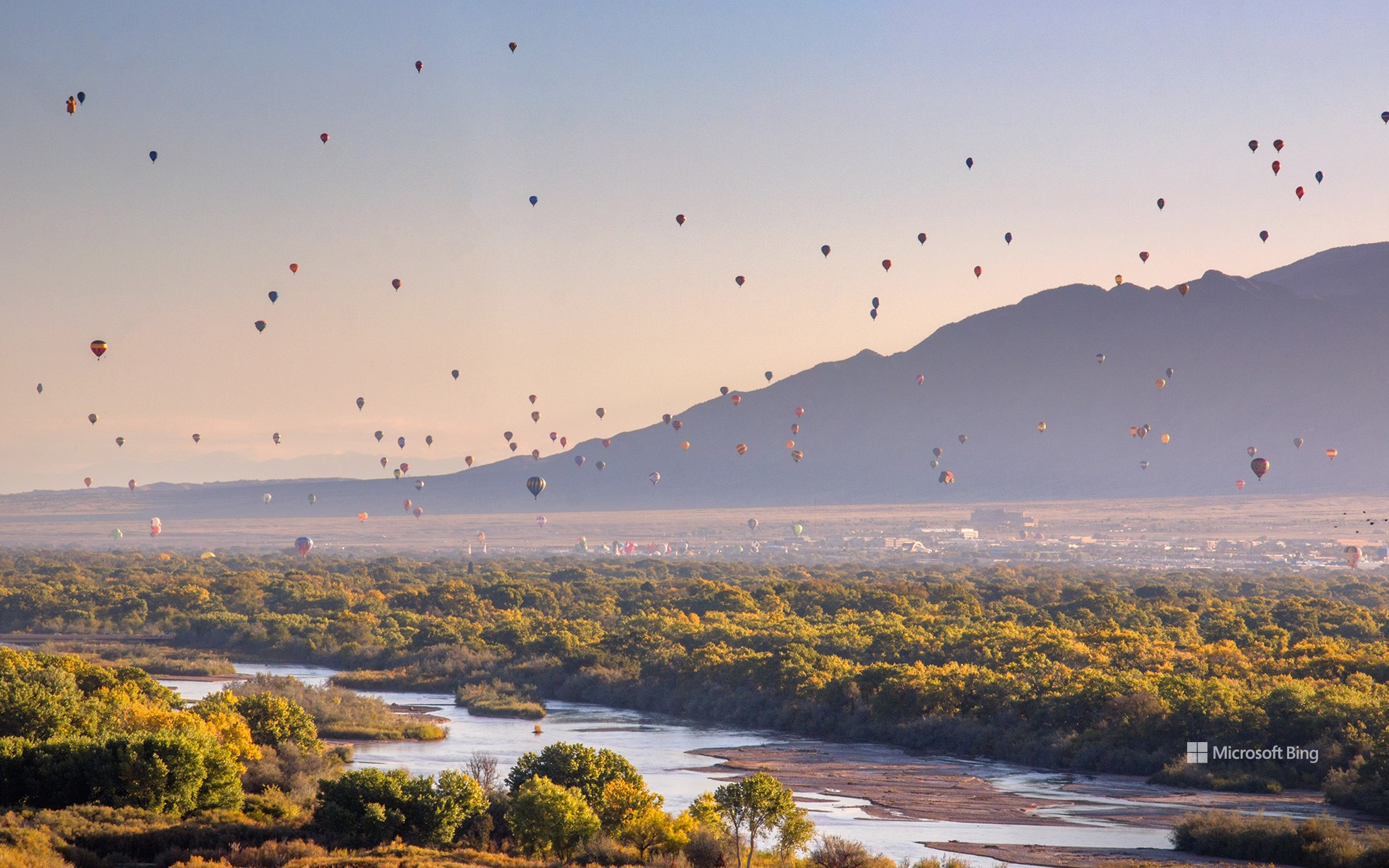
今天是热气球升空日,一个致力于纪念布兰沙尔的成就的日子。布兰沙尔是一位法国的气球驾驶员及发明家,早在1793年,他就完成了美国历史上第一次载人气球航行,从费城飞往新泽西州的德特福德。自2011年起,每年的这一天人们都会热烈庆祝,以致敬这一空中壮举。在今天的图片中,太阳落在格兰德河的上空,照亮了新墨西哥州阿尔伯克基上空的彩色热气球。每年的10月初,人们从世界各地赶来齐聚一堂,参加为期9天的阿尔伯克基国际热气球节,这是世界上最盛大的热气球节,在这里,人们可以欣赏到经验丰富的热气球驾驶员熟练地操作他们的热气球。
Balloon Ascension Day
Up, up, and away! Today is Balloon Ascension Day, celebrating the anniversary of the first manned balloon flight in North America. French aeronaut Jean-Pierre Blanchard's flight took him from Philadelphia to Deptford, New Jersey, back in 1793. Interest in ballooning took off from there and today, hot air balloon festivals take place across the country, including Albuquerque, where today's sunrise image was taken. Every year, hundreds of thousands of people attend the nine-day Albuquerque International Balloon Fiesta—the largest hot air balloon festival in the world—to see skilled pilots expertly maneuver their baskets through balloon-filled skies.
普韦布洛·博尼托镇,查科文化国家历史公园,美国新墨西哥州 Pueblo Bonito, Chaco Culture National Historical Park, New Mexico (© Ian Shive/Tandem Stills + Motion)
普韦布洛·博尼托镇,查科文化国家历史公园,美国新墨西哥州 Pueblo Bonito, Chaco Culture National Historical Park, New Mexico (© Ian Shive/Tandem Stills + Motion)
如果这些墙会说话······ If these walls could talk...
查科文化国家历史公园,美国新墨西哥州
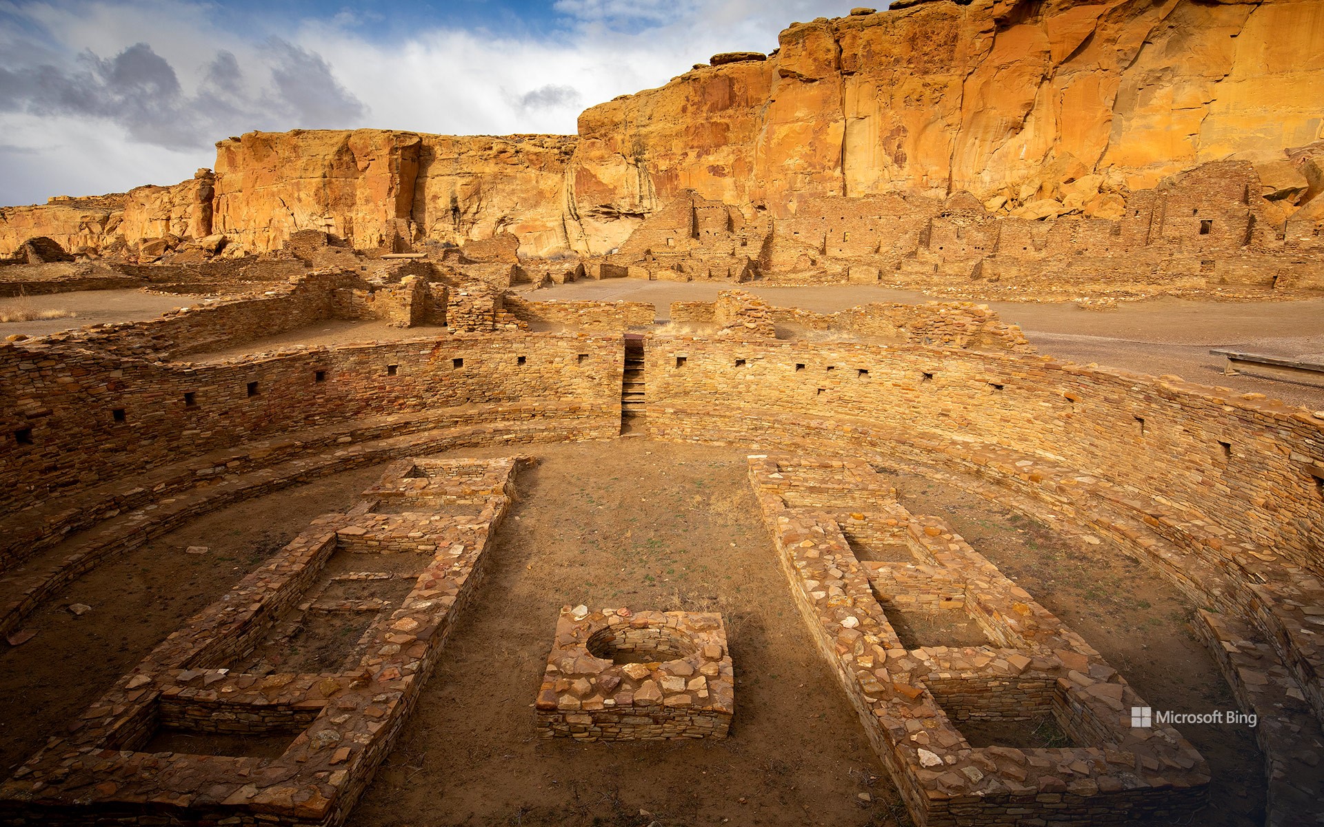
数百年来,新墨西哥州的查科峡谷一直是普韦布洛人祖先的主要文化中心,他们的族群在这里扎根并繁荣起来。然而,由于高地沙漠冬季漫长、少雨且生长季节短暂,在这里生活并非易事。尽管面临这些挑战,普韦布洛人还是找到了在这个条件艰苦的地方繁荣发展的方法。今天,查科文化国家历史公园让我们得以窥见古老的普韦布洛人的文化、传统和价值观。该遗址是史前时代举办典礼的公共建筑的所在地,建筑风格具有普韦布洛文化的独特特征。这些建筑仿照古代的悬崖民居,由石灰石块或土坯砖建造而成。
Chaco Culture National Historical Park, New Mexico
These circular walls belong to Pueblo Bonito, one of the biggest great homes in Chaco Culture National Historical Park, New Mexico. Between around 850 CE and 1250 CE, Chaco Canyon became a major cultural center for the Ancestral Puebloans, who lived in what is now known as the Four Corners region.
With long winters, little rain, and short growing seasons, the high desert wasn't the easiest place to live but the Pueblo people found ways to thrive here. Today, the park offers a glimpse into an ancient culture's traditions and way of life. The site is home to remnants of prehistoric ceremonial and massive stone buildings, called great houses. Pueblo Bonito, pictured on our homepage, took decades to build and stood four or five stories tall with more than 600 rooms. It would have been used for ceremonies, commerce, astronomy, hospitality, and more. Eventually, Chaco's influence declined, and the people moved on. These ruins are a window onto its glorious past, at the heart of an ancient civilization.
阿尔伯克基国际气球节上的气球, 阿尔伯克基市, 新墨西哥州 Balloons at the Albuquerque International Balloon Fiesta in Albuquerque, New Mexico (© gmeland/Shutterstock)
阿尔伯克基国际气球节上的气球, 阿尔伯克基市, 新墨西哥州 Balloons at the Albuquerque International Balloon Fiesta in Albuquerque, New Mexico (© gmeland/Shutterstock)
最古老的飞行方式 The oldest way to fly
Albuquerque International Balloon Fiesta
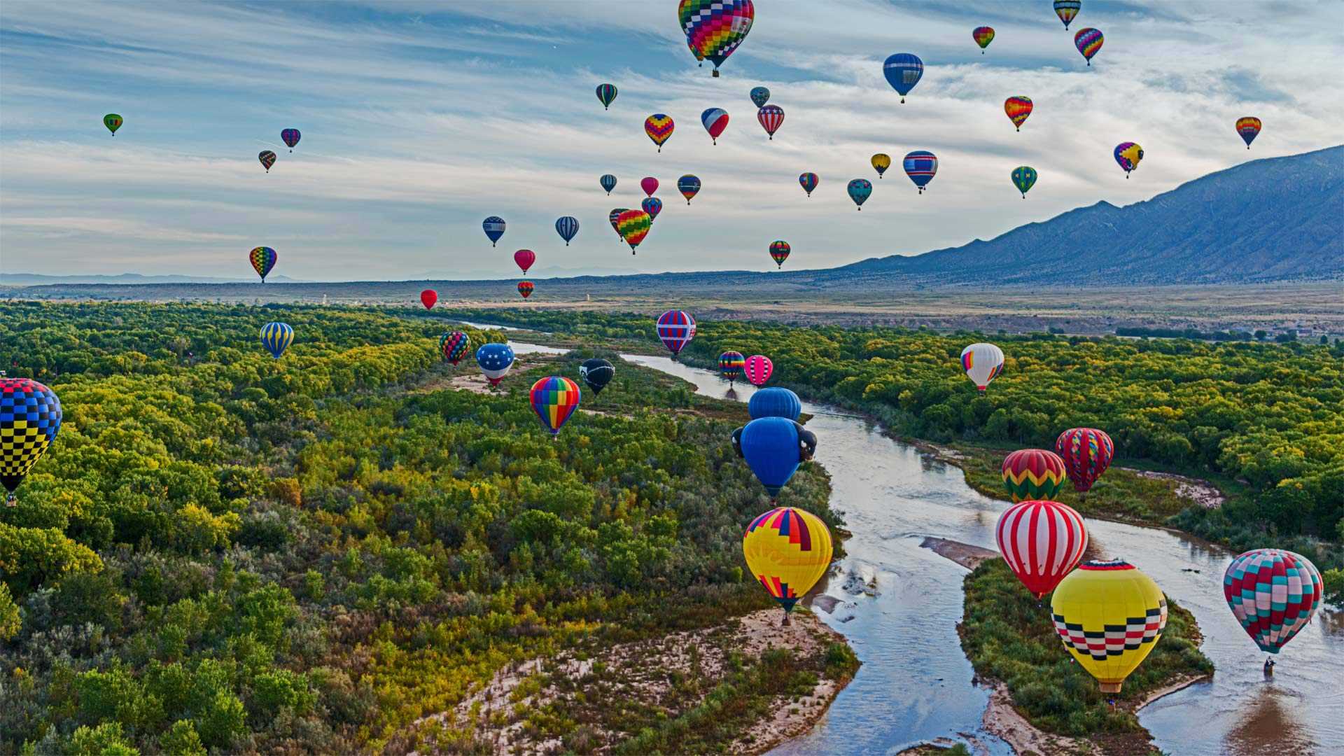
October means pumpkin fields, Halloween, leaf-peeping, and the World Series. But in Albuquerque, New Mexico, the beginning of October means a skyful of hot air balloons. The 50th Albuquerque International Balloon Fiesta is the largest gathering of balloonists in the world, with more than 500 hot air balloons going aloft this week. The now 9-day event got its start by launching 13 balloons from a shopping mall parking lot in 1972 to celebrate the birthday of a local radio station. It has easily become the biggest event of the year in Albuquerque, whose entire populace can view balloons in flight simply by stepping outside their homes and looking up.
The event is staged from the 365-acre Balloon Fiesta Park, on the northern outskirts of Albuquerque with the Sandia Mountains a few miles away. The Balloon Fiesta claims to be the most photographed event in the world, and it's easy to understand why. The highlight of the week is a mass ascension, in two waves, of all the balloons, decorated with every color and some shaped like animals or cartoon characters. In the age of jets and helicopters and rockets, this mass celebration of nearly silent flight reminds us that the magic of flying is not about speed, but simply reaching the sky.
国际热气球节
十月意味着南瓜田、万圣节、偷看树叶和世界系列赛。但在新墨西哥州的阿尔伯克基,10月初意味着满天都是热气球。第50届阿尔伯克基国际气球节是世界上最大的气球爱好者聚会,本周有500多个热气球升空。1972年,为了庆祝当地广播电台的生日,这项为期9天的活动从一个购物中心停车场发射了13个气球开始。它很容易成为阿尔伯克基一年中最大的盛事,那里的全体民众只要走出家门,抬头就能看到飞行中的气球。
该活动在365英亩的气球嘉年华公园举行,该公园位于阿尔伯克基北郊,距离桑迪亚山脉几英里。气球嘉年华声称是世界上拍摄次数最多的活动,原因很容易理解。本周的亮点是所有气球的两次大规模提升,气球上装饰着各种颜色,有些形状像动物或卡通人物。在喷气式飞机、直升机和火箭的时代,这种近乎无声飞行的大规模庆祝活动提醒我们,飞行的魔力不在于速度,而仅仅在于飞向天空。
圣达菲附近的岩石艺术, 新墨西哥州 Rock art near Santa Fe, New Mexico (© Scott Warren/Cavan)
圣达菲附近的岩石艺术, 新墨西哥州 Rock art near Santa Fe, New Mexico (© Scott Warren/Cavan)
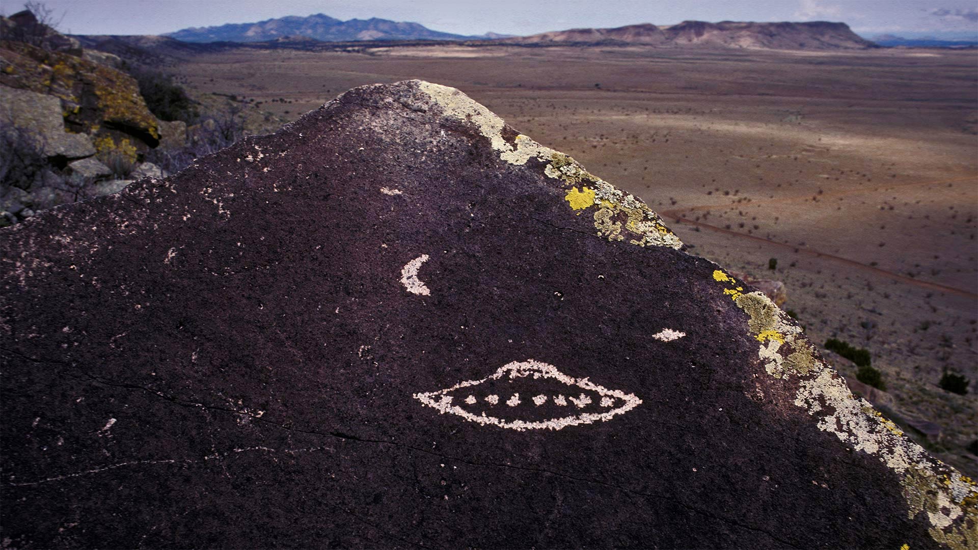
真相就在那里,但不是在这块石头上 The truth is out there…but not on this rock
Graffiti near Santa Fe, New Mexico
Evidence of ancient aliens? Nah, more likely the etchings of a prankster hiker. Though Pueblo cultures here in northern New Mexico made pictographs in this style several centuries ago, there's no evidence they were depicting extraterrestrials. But don't get us wrong: We want to believe.
Today is Extraterrestrial Culture Day, a holiday that enjoys official status in New Mexico thanks to the 'Roswell incident' of 1947. Depending who you ask, the metallic wreck found on a remote ranch in New Mexico one July morning was either a weather balloon, a top-secret military device disguised as a weather balloon, or a bona fide alien craft. Whatever the truth, the nearby town of Roswell has gone all-in on UFO lore. It's home to numerous UFO-themed attractions, chief among them the International UFO Museum and Research Center.
新墨西哥州圣达菲附近的涂鸦
古代外星人的证据?不,更像是恶作剧徒步旅行者的蚀刻。虽然新墨西哥州北部的普韦布洛文化在几个世纪前就以这种风格制作了象形文字,但没有证据表明它们描绘了外星人。但不要误解我们:我们想要相信。
今天是外星文化日,由于1947年的“罗斯韦尔事件”,这个节日在新墨西哥州享有官方地位。7月的一天早上,在新墨西哥州一个偏远的牧场上发现的金属残骸,要么是一个气象气球,要么是伪装成气象气球的绝密军事设备,要么是一艘真正的外星人飞船。不管真相是什么,附近的罗斯韦尔镇已经完全沉浸在UFO的传说中。这里有许多以UFO为主题的景点,其中最主要的是国际UFO博物馆和研究中心。
比斯蒂荒野上的“外星孵化场”,新墨西哥州 The 'Alien Egg Hatchery' in the Bisti/De-Na-Zin Wilderness, New Mexico (© Ian Shive/Tandem Stills + Motion)
比斯蒂荒野上的“外星孵化场”,新墨西哥州 The 'Alien Egg Hatchery' in the Bisti/De-Na-Zin Wilderness, New Mexico (© Ian Shive/Tandem Stills + Motion)
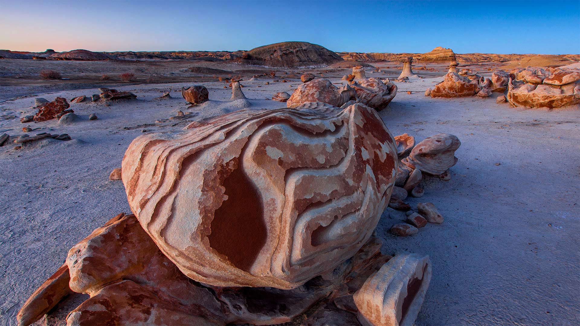
Welcome to the 'Alien Egg Hatchery'
The otherworldly rock formations in the Bisti/De-Na-Zin Wilderness inspired some creative names—such as the 'Alien Egg Hatchery' seen in this photo. More than 70 million years ago, this desert was a tidal swamp along the shore of the long-evaporated Western Interior Seaway that once bisected North America. A diverse array of sediment and rock was deposited by the waters, and after the seaway retreated, the rocks remained.
Today, these inspiring desert landscapes are a protected area thanks to the Wilderness Act of 1964. If you're planning a road trip along any of New Mexico's Scenic Byways, make time for the Trails of the Ancients Byway, which will take you directly to Bisti/De-Na-Zin.
欢迎来到“外星人蛋孵化场”
在Bisti/De Na Zin荒野中,超凡脱俗的岩层激发了一些创造性的名字,如照片中的“外星人蛋孵化场”。7000多万年前,这片沙漠是一片潮汐沼泽,位于蒸发已久的西部内陆海道沿岸,曾经将北美一分为二。海水沉积了各种各样的沉积物和岩石,在海道后退后,岩石仍然存在。
如今,由于1964年的《荒野法案》,这些令人振奋的沙漠景观已成为保护区。如果你计划沿着新墨西哥州的任何一条风景优美的小路进行公路旅行,请腾出时间去参观古人的小路,这条小路将直接带你到比斯蒂/德纳津。
2012年5月20日新墨西哥上空的日环食 Annular eclipse over New Mexico, May 20, 2012 (© ssucsy/Getty Images)
2012年5月20日新墨西哥上空的日环食 Annular eclipse over New Mexico, May 20, 2012 (© ssucsy/Getty Images)
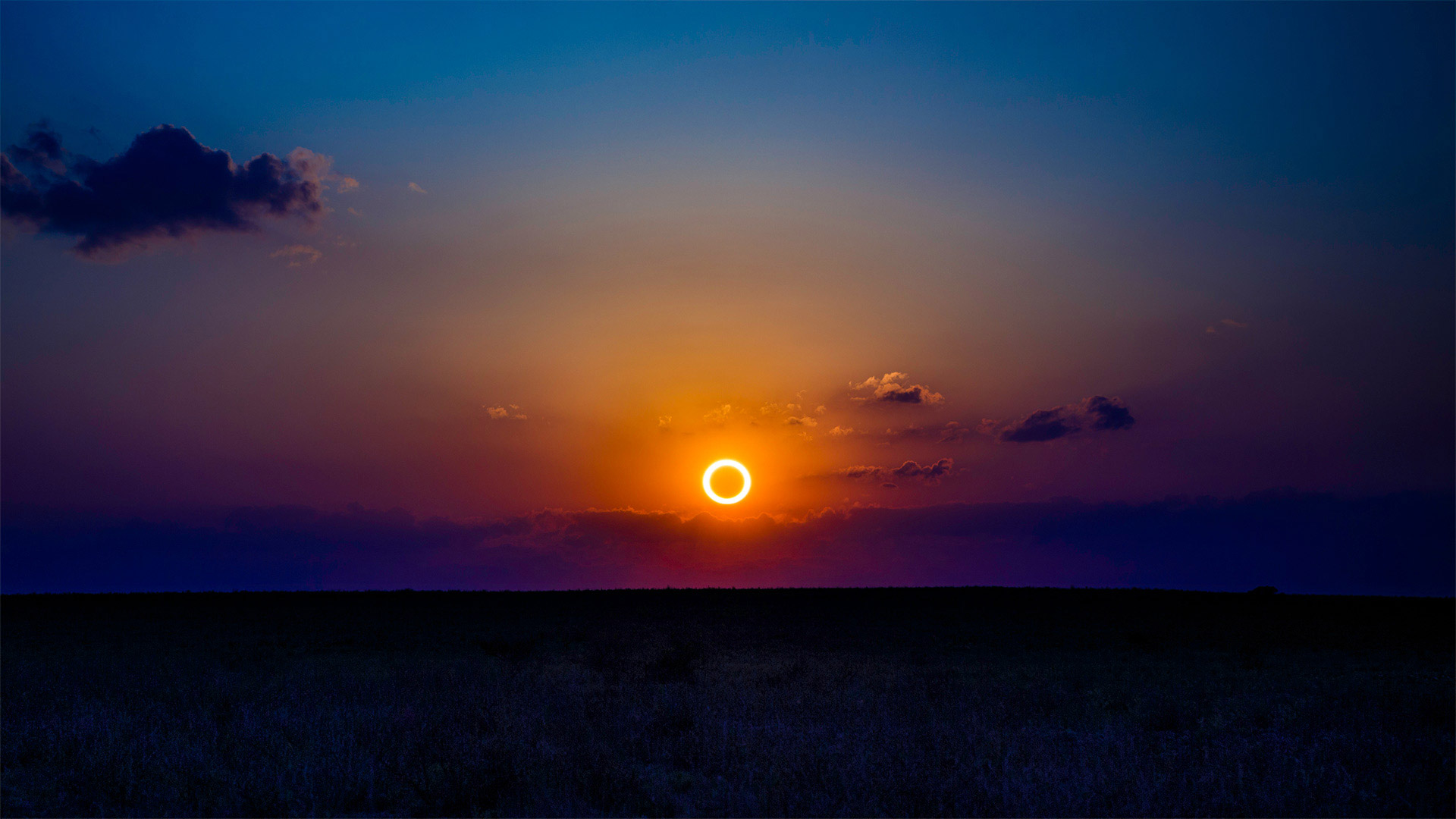
Ring of fire
No, this isn't some kind of early promo for 'Halo: Infinite.' Today's homepage image shows an annular solar eclipse captured in New Mexico in 2012. ('Annular' is just a fancy word for doughnut-shaped.) It's not unlike the eclipse some northerly parts of the world will enjoy today.
Annular eclipses like today's occur when the moon is at its apogee, or the furthest distance in its orbit from Earth. Since the moon looks its smallest to us now, it can't fully cover the sun—but the lucky few living in far northern Canada, Scandinavia, and Siberia will have tickets to a one-ring solar circus once everything lines up just right.
火环
不,这不是“光环:无限”的早期宣传。今天的主页图片显示了2012年在新墨西哥州拍摄的一次日环食。(“日环食”只是甜甜圈形状的一个花哨的词。)这和今天世界上一些偏北地区将享受的日食没什么不同。
像今天这样的环食发生在月球的最远点,或者说是其轨道上离地球最远的地方。由于月球现在看起来是最小的,它不能完全遮住太阳,但生活在遥远的加拿大北部、斯堪的纳维亚半岛和西伯利亚的少数幸运儿,一旦一切都安排得恰到好处,就会有单圈太阳马戏团的票。
红石公园教堂岩附近的雷击,新墨西哥州 Lightning strikes near rock formation, Church Rock, Red Rock Park, New Mexico (© Tim Fitzharris/Minden Pictures)
红石公园教堂岩附近的雷击,新墨西哥州 Lightning strikes near rock formation, Church Rock, Red Rock Park, New Mexico (© Tim Fitzharris/Minden Pictures)
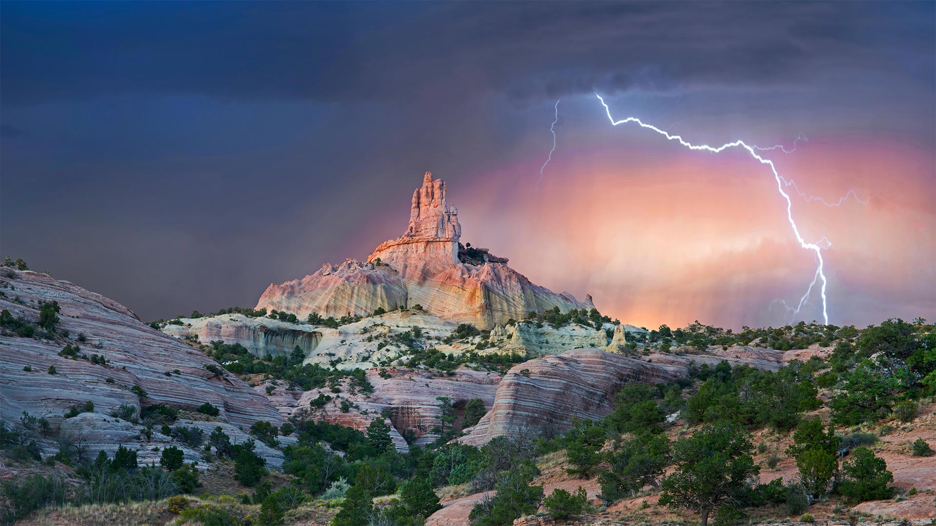
Struck by Southwestern beauty
It's okay if this stormy shot stirs your spirit with holy awe: They call this wind-carved edifice Church Rock for a reason. Surrounded by an enchanting Southwestern landscape, it's a sight that almost invites you to get lost out here—and if you look at a map of these parts, you'll see that's not too hard.
We're in the 'checkerboard' region of western New Mexico, where patchwork borders separate sovereign Navajo Nation grounds and private land from that administered by an alphabet soup of federal, state, and local agencies. (For its part, Church Rock was the crown jewel of a state park before it was returned to the Navajo in 1989, while the city of Gallup now maintains the nearby parkland.) Maybe it's simpler to think in terms of a more ancient boundary line: The Great Continental Divide, marking the border between North America's Atlantic- and Pacific-destined waters, crosses Route 66 just east of the checkerboard.
为西南美景所震撼
如果这狂风暴雨的镜头激起你神圣的敬畏,那也没关系:他们称这座风雕大厦为教堂岩石是有原因的。四周环绕着迷人的西南景观,这种景象几乎会让您迷失在这里——如果你看看这些地方的地图,你会发现这不是太难。
我们在新墨西哥州西部的“棋盘格”地区,这里的边界错落有致,将纳瓦霍族主权国家的土地和私人土地与联邦、州和地方机构管理的土地分隔开来。(教堂岩在1989年被归还纳瓦霍之前是国家公园的王冠宝石,而盖洛普市现在保留着附近的公园。)也许用一条更古老的边界线来思考更简单:大洲分水岭,在北美洲大西洋和太平洋水域之间的边界,穿过66号公路,就在棋盘的东边。
白沙国家公园中的石膏沙丘,新墨西哥 Gypsum sand dunes, White Sands National Park, New Mexico (© Grant Kaye/Cavan Images)
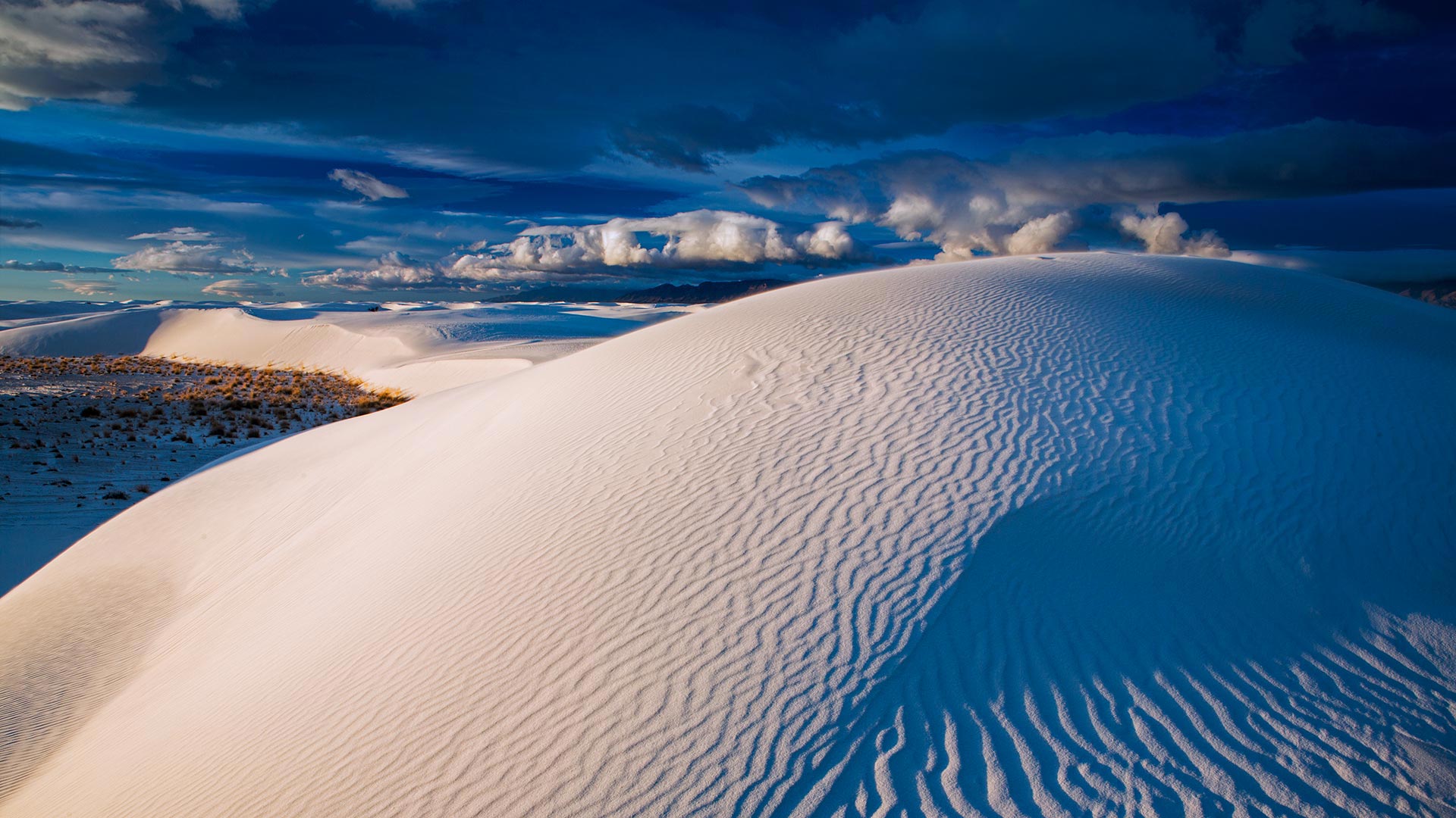
白沙国家公园中的石膏沙丘,新墨西哥 Gypsum sand dunes, White Sands National Park, New Mexico (© Grant Kaye/Cavan Images)
Sands of time
At a quick glance, you might mistake these dunes for massive snowdrifts. Although they do make for great sledding, the tiny crystals that make up White Sands National Park are not ice but gypsum, a soft mineral often used to make plaster and chalk. The dune field became a national monument on this day in 1933 with a proclamation by President Herbert Hoover, which set aside nearly 150,000 acres for preservation. Recently, on December 20, 2019, President Trump signed legislation making it the 62nd designated national park in the National Park System.
The pearly sands compose the largest gypsum dune field in the world but cover just a fraction of southern New Mexico's Tularosa Basin. This vast desert valley—more extensive than some US states at 6,500 square miles—is mostly occupied by White Sands Missile Range. The active military installation—the US's largest by area—surrounds the national park and includes the Trinity site, where the first atomic bomb was detonated in 1945. That event altered the course of humanity's future, but the White Sands region is also defined by echoes from our very distant past: recently, scientists have used radar technology to zero in on prehistoric human, mammoth, and giant sloth footprints buried long ago beneath the shifting sands.
International UFO Museum and Research Center, Roswell, New Mexico © Walter Bibikow/Danita Delimont
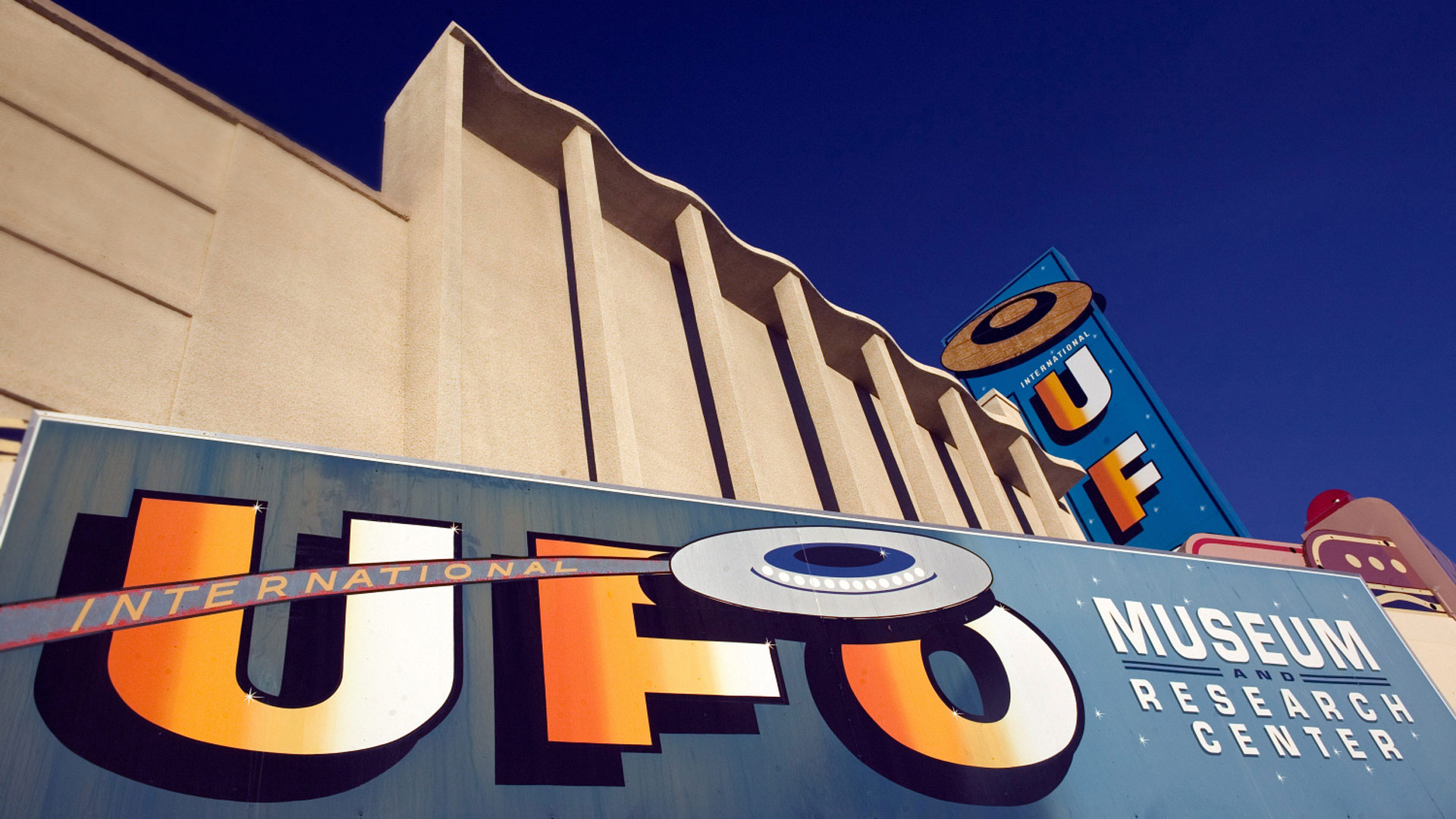
International UFO Museum and Research Center, Roswell, New Mexico © Walter Bibikow/Danita Delimont