标签 亚利桑那 下的文章
大峡谷国家公园,亚利桑那州,美国 Grand Canyon National Park, Arizona (© Jeremy Janus/Getty Images)
大峡谷国家公园,亚利桑那州,美国 Grand Canyon National Park, Arizona (© Jeremy Janus/Getty Images)
深不见底的鸿沟 Deeply chasm-matic
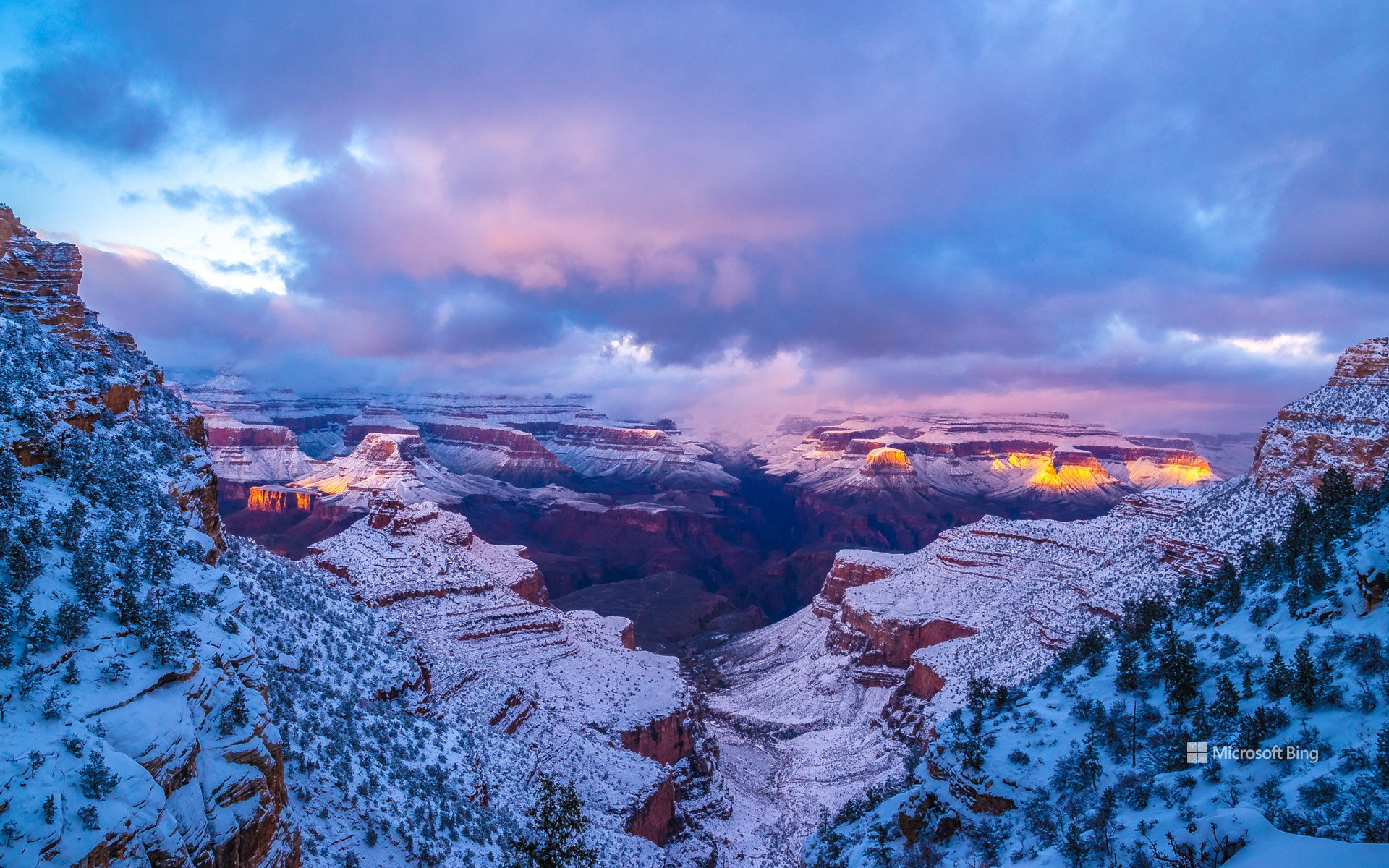
大峡谷国家公园105岁生日
祝大峡谷国家公园生日快乐!今天是由亚利桑那州科罗拉多河雕刻而成的著名峡谷的一个里程碑:自伍德罗·威尔逊总统于1919年将其指定为国家公园以来,已经过去了105年。大峡谷是由河流、风和山体滑坡形成的独特景观,它的起源可以追溯到500万到600万年前。大峡谷承载着印第安人、欧美拓荒者和旅行者的故事,还有陡峭的山谷和五颜六色的岩层等地质奇观。所有的这些区域都由国家公园管理局监管。除了在科罗拉多河上巡游、参加时光之路徒步旅行或登上沙漠景观瞭望塔等旅游冒险活动以外,该公园还是联合国教科文组织指定的世界遗产和注册在案的国际黑暗天空公园,你可以在这里观赏到清澈的星空。
Grand Canyon National Park turns 105
Happy birthday to Grand Canyon National Park! It's been 105 years since this Arizona landmark was designated a national park by President Woodrow Wilson in 1919. The origins of this exceptional landscape, carved by the Colorado River, wind, and landslides, date back up to 6 million years. Alongside its steep valleys and colorful rock formations, the canyon holds the stories of Native Americans, European, and American pioneers—the oldest human artifacts found here date back nearly 12,000 years. In addition to tourist adventures such as cruising on the Colorado River, joining the Trail of Time walking tour, or climbing up to the Desert View Watchtower, the park is also a UNESCO World Heritage Site and a registered International Dark Sky Park for crystal-clear stargazing.
砂岩岩层,红悬崖国家保护区,亚利桑那州,美国 Sandstone rock formations, Vermilion Cliffs National Monument, Arizona (© Yva Momatiuk and John Eastcott/Minden Pictures)
砂岩岩层,红悬崖国家保护区,亚利桑那州,美国 Sandstone rock formations, Vermilion Cliffs National Monument, Arizona (© Yva Momatiuk and John Eastcott/Minden Pictures)
时光雕琢 Sculpted by time
红悬崖国家保护区,亚利桑那州
位于亚利桑那州的红悬崖国家保护区有层层叠叠的砂岩岩层、高耸的石柱和超现实的狭缝型峡谷。该保护区建于2000年,因该地岩层的主色调为鲜红色而得名“红悬崖”。一旦你获得了参观这一独特的户外景点的许可证,请一定要去参观波浪谷:这是一个令人惊叹的地质奇观,流动状的岩石层就像凝固的红色液体。该保护区的奇观还包括眼镜蛇拱门和由砂岩结构组成的白口袋岩层。白口袋的岩层不仅有交叉的层理和漩涡状图案,还有白色、红色和橙色等多种颜色。
Vermilion Cliffs National Monument
Vermilion Cliffs National Monument in Arizona features sandstone rock formations, towering hoodoos, and surreal slot canyons. The monument, established in 2000, was named after the vibrant red hues that dominate this sandstone landscape. Once you get a permit to take part in this outdoor excursion, make sure to visit the Wave. It's a stunning geological wonder, with flowing layers of rocks that look like red liquid that has been frozen in time. Other visual treats include Cobra Arch and the White Pocket rock formations, featuring swirling patterns in white, red, and orange.
巨人柱,铁木森林国家纪念地,亚利桑那州,美国 Saguaro cacti, Ironwood National Monument, Arizona (© Jack Dykinga/Minden Pictures)
巨人柱,铁木森林国家纪念地,亚利桑那州,美国 Saguaro cacti, Ironwood National Monument, Arizona (© Jack Dykinga/Minden Pictures)
你今天过得怎么样? 'Saguaro' you today?
巨人柱,铁木森林国家纪念地,亚利桑那州,美国
在亚利桑那州阳光普照的天空下,大片的仙人掌在群山的映衬下格外显眼。照片上的是巨人柱仙人掌,拍摄于铁木森林国家纪念地。即使你没有亲眼见过巨人柱仙人掌,但当你听到“巨人柱”这个名字时,也能联想到它们的样子:苍绿高大的圆柱形仙人掌,直指天空。虽然巨人柱生长缓慢,但它们的寿命超过200年,有足够的时间慢慢生长,创纪录的一株巨人柱仙人掌甚至高达78英尺。曾有一株被称为“老爷爷”的仙人掌存活了约有300年,最终在20世纪90年代寿终正寝。
Saguaro cacti, Ironwood Forest National Monument, Arizona
Massive succulents against a mountainous backdrop, underneath the sun-kissed Arizona sky—it's prickly perfection. Pictured here are saguaro (pronounced 'sah-wah-roh') cacti at the Ironwood Forest National Monument in the Sonoran Desert. Even if you haven't seen one in person, when you hear the word cactus, you're probably thinking of saguaro—tall, green, cylindrical, with arms pointing upward. From tattoos to coffee cups, you'll find this iconic symbol of Arizona on almost everything. Though they are slow growers, these plants have been known to live over 200 years and reach enormous heights, with a 78-footer setting the record. Another cactus, known as 'Grandaddy,' survived in the sweltering desert for about 300 years, eventually succumbing to old age in the early 1990s. Cacti may not be for everyone, but they tend to grow on you (figuratively, of course)!
塞多纳,亚利桑那州,美国 Sedona, Arizona (© Jonathan Ross/Getty Images)
塞多纳,亚利桑那州,美国 Sedona, Arizona (© Jonathan Ross/Getty Images)
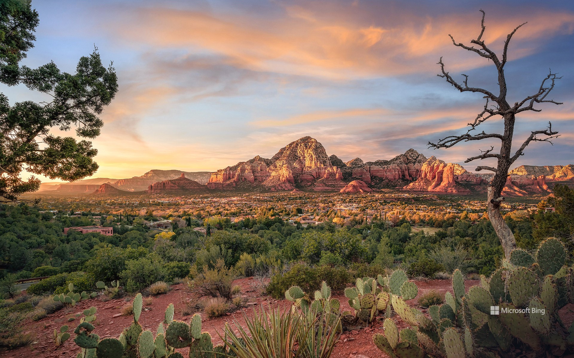
红石的土地 Red rock country
塞多纳,亚利桑那州,美国
从你踏入塞多纳的那一刻起,你将会震撼于其绝妙的景色和从沙漠中突兀而出的红色砂石悬崖。冒险爱好者热爱这里的美景和宁静。塞多纳还遍地是美洲原住民的历史。尽管由于缺少文字记述,我们对于这个地区最早的定居者知之甚少,他们被称为“祖先普韦布洛人”。普遍认为他们在1400年前在此定居。大部分有关这些古代先民的信息来自于考古遗迹和文物,包括大规模的普韦布洛人定居点遗址。
Sedona, Arizona
Stunning sandstone cliffs rise from the desert floor amid spectacular scenery here in Sedona, Arizona, also known as Red Rock Country. Adventure enthusiasts come to enjoy the beautiful trails that dot the region, which is also steeped in Native American history. The earliest settlers are believed to have been the Ancestral Puebloans, who inhabited the area around 1,400 years ago. Without any written history, most of the information about these ancient people comes from the archaeological ruins that remain, including cliff dwellings built under overhangs in the area's red sandstone rocks. Other Native American groups came to the area such as the Hakataya, the Hohokam, the Sinagua, and the modern-day tribes that live in Arizona today, the Tonto Apache and the Yavapai.
大峡谷国家公园的南凯巴布步道,亚利桑那州,美国 South Kaibab Trail in Grand Canyon National Park, Arizona (© Roman Khomlyak/Getty Images)
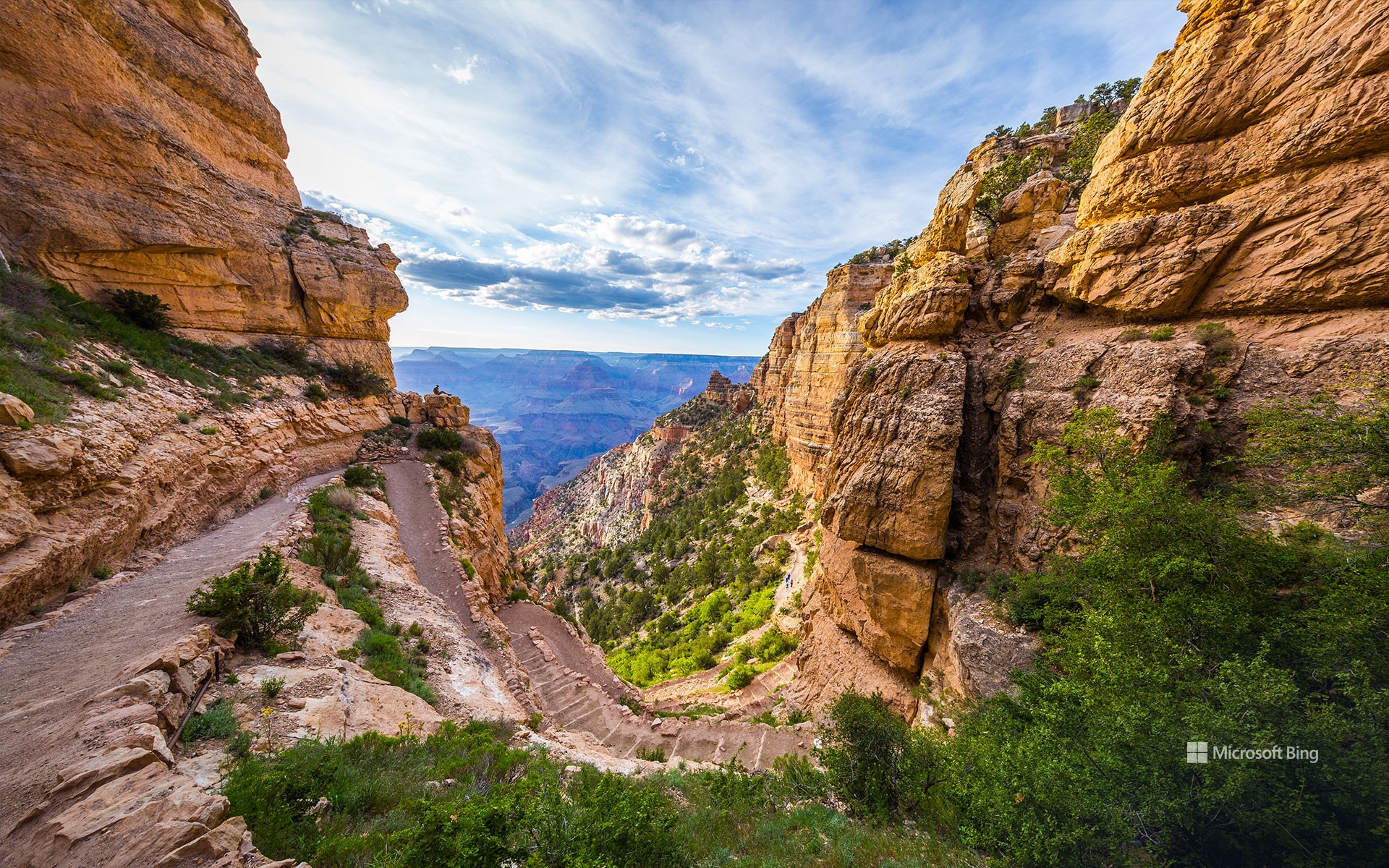
大峡谷国家公园的南凯巴布步道,亚利桑那州,美国 South Kaibab Trail in Grand Canyon National Park, Arizona (© Roman Khomlyak/Getty Images)
一睹最壮观的峡谷 A glimpse of the grandest of canyons
大峡谷国家公园,美国亚利桑那州
今天是美国国家步道日,也是远足的最佳时机,也提醒大家要保护远足路线,让每个人都能享受这份快乐。想找个绝佳的地方活动活动吗?今天照片里位于大峡谷的南凯巴布步道就是个好去处。这条路线从被称为“烟囱”的急转弯开始,通向一个陡峭狭窄的下坡路,等待你的将是一次令人振奋的旅程。新鲜空气和运动可以改善你的情绪和睡眠,增强体力和耐力,并降低患心脏病的风险。此外,环境的变化还可以激发创造力,启发新思路。
National Trails Day
Today is a great day to take a hike! Each year, National Trails Day brings together nature lovers, government agencies, and businesses to preserve hiking trails for everyone to enjoy. Looking for a stunning spot to stretch your legs? We suggest South Kaibab Trail in the Grand Canyon, seen here. The trail starts with a series of switchbacks known as 'The Chimney,' which leads to a steep, narrow descent—prepare for an invigorating workout! All that hard work will pay off though—fresh air and exertion can boost your mood, improve sleep, and reduce the risk of heart disease. Not to mention the panoramic views you can enjoy from the trail's scenic viewpoints.
月亮升起,图森,亚利桑那州,美国 Moon rising, Tucson, Arizona (© Tim Murphy/Shutterstock)
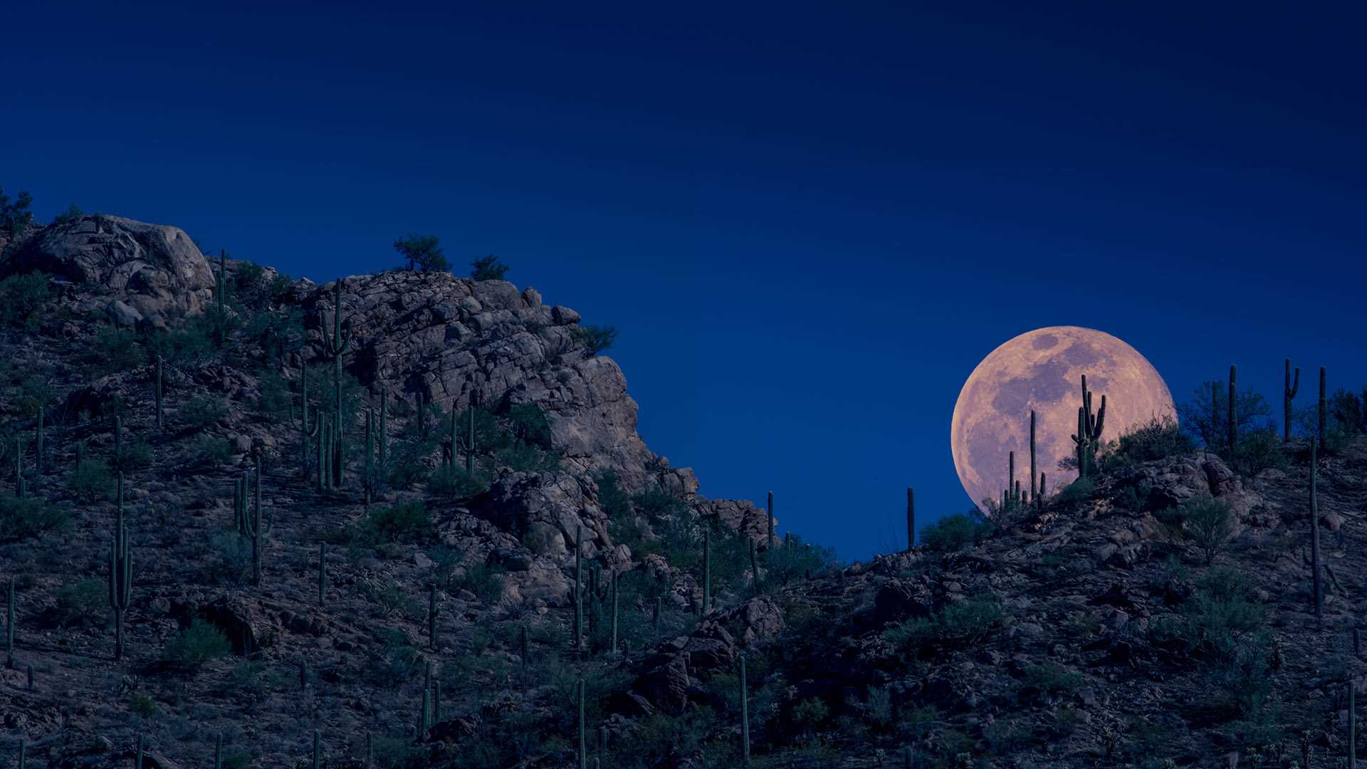
月亮升起,图森,亚利桑那州,美国 Moon rising, Tucson, Arizona (© Tim Murphy/Shutterstock)
亚利桑那州空中的粉月亮 A pink moon over Arizona
四月的第一个满月
夜空中的满月是动人心魄的。人类是如此为月亮着迷,北美地区甚至起了各种各样的名字描述它的不同状态:蓝月、蛋月、狩月、玫瑰月、海狸月等等等等。今天照片里展示的粉月就是亚利桑那州四月的第一轮满月,但这个粉色却并非是日期造成的。阳光从月表上反射后穿透地球大气层,大气中的灰尘、污染、烟雾和其他粒子散射月光,从而改变了月光的颜色,使其从白色或是蓝色变成了红色、橙色、黄色、或是粉色。当月亮低悬于空中时,月光需要穿透更厚的大气层,也就更有可能变为其他的颜色。也许是亚利桑那州沙漠的沙尘导致了这轮美丽的粉月吧。
April's full moon
The full moon has inspired folklore, myths, writers, and artists throughout history and has been given many names, depending on the time of year it appears. April's first full moon is known as the pink moon, but that doesn’t mean it will appear pink against the night sky. Native Americans named it for the pink wildflowers, moss pink or creeping phlox, that bloom in the eastern US in the spring.
If it does appear pink, orange, or golden, it is because sunlight reflects off the moon and travels through our atmosphere. Here, dust, pollution, and other particles scatter the light, making it appear more colorful when it hangs lower in the sky. It appears whiter as it rises. Perhaps this pink moon is tinged by the dust of the Arizona desert.
下羚羊峡谷,亚利桑那州,美国 Lower Antelope Canyon near Page, Arizona (© AZCat/Getty Images)
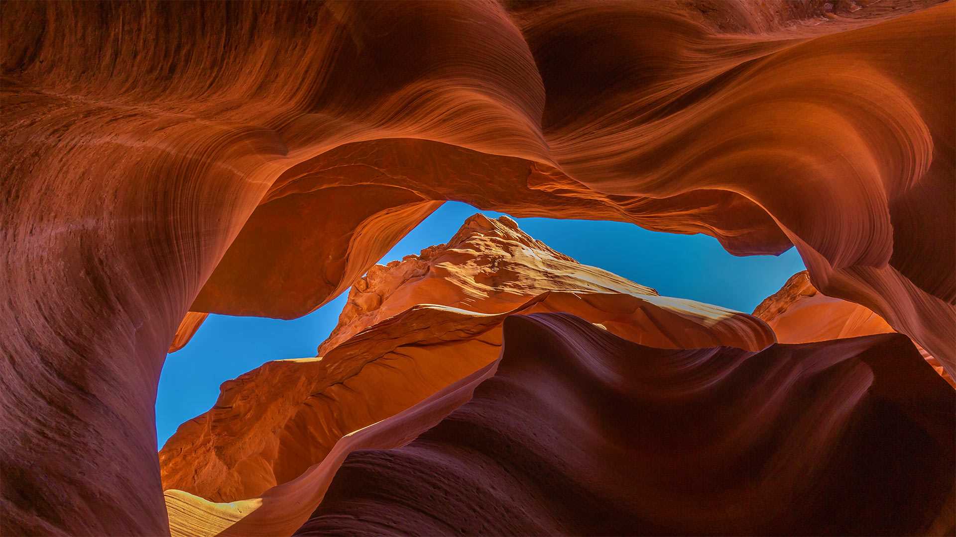
下羚羊峡谷,亚利桑那州,美国 Lower Antelope Canyon near Page, Arizona (© AZCat/Getty Images)
这些美丽的岩石波浪是什么? What are these beautiful sandy waves?
下羚羊峡谷,美国亚利桑那州
下羚羊峡谷是位于美国亚利桑纳州的一个美丽的自然景点。该峡谷也被原住民纳瓦霍人称为“螺旋石拱”。下羚羊峡谷不仅吸引了观景游客、徒步者,其鲜艳的色彩还吸引了许多摄影师。下羚羊峡谷呈“V”字形,这一独特的地貌是水流长年冲刷谷壁而形成的。羚羊峡谷的名字来源于纳瓦霍人的传说故事:过去,羚羊们会在冬天沿着峡谷漫步吃草。
Lower Antelope Canyon, Arizona
Lower Antelope Canyon is a beautiful natural tourist attraction located in Arizona. This canyon is also known as Hazdistazí (spiral rock arches) among the indigenous Navajo people. The canyon is not just a sight to behold and great for a hike, but with its beautiful hues is also a photographer's dream come true. The canyon is shaped like a 'V,' its unique geography created by water that rushed over its walls over many, many years. Antelope Canyon gets its name from Navajo stories regarding antelopes that grazed along the canyon in the wintertime.
大理石峡谷中横跨科罗拉多河的纳瓦霍桥,美国亚利桑那州北部 Marble Canyon bridges over the Colorado River at the Glen Canyon National Recreation Area in northern Arizona (© trekandshoot/Alamy)
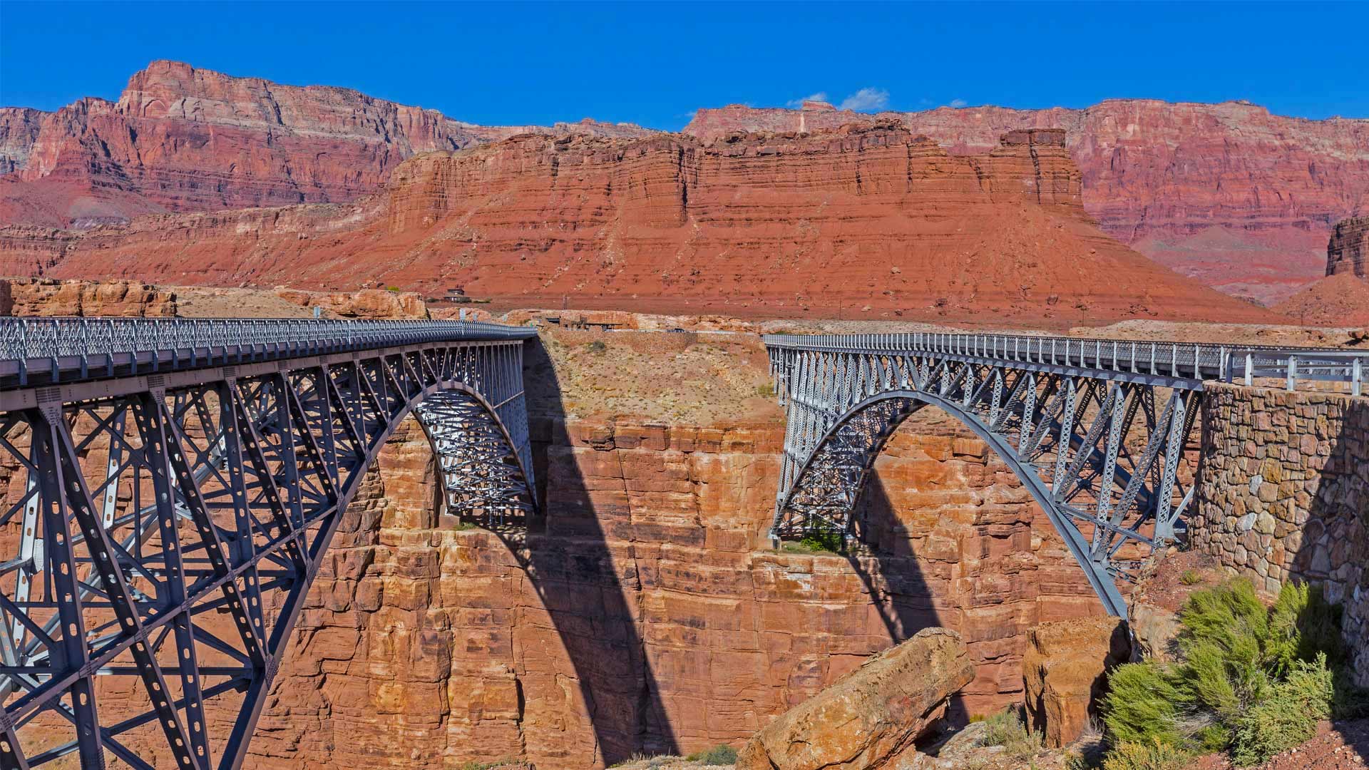
大理石峡谷中横跨科罗拉多河的纳瓦霍桥,美国亚利桑那州北部 Marble Canyon bridges over the Colorado River at the Glen Canyon National Recreation Area in northern Arizona (© trekandshoot/Alamy)
横跨峡谷裂缝的两座桥 Bridging the gap two ways
Happy birthday, bridges
Today we're taking a trip to a part of northern Arizona cut off from the rest of the state by the Colorado River and its deep canyons. No doubt you've heard of the Grand Canyon, but today is an important milestone to another canyon about 70 miles away. On this date in 1995, the twin Marble Canyon bridges, better known collectively as Navajo Bridge, were officially dedicated as the second bridge was installed.
The first, in place since 1929 when it was hailed as a 'modern marvel' and 'the biggest news in Southwest history,' had long been key to travel across the 834-foot gap of Marble Canyon. But as time passed, the area saw heavier vehicles and more traffic. After much debate about the impact on Native land and endangered plants, and the likelihood of debris falling into the river below, plans were developed for the $14.7 million, nearly identical second bridge. Now, Marble Canyon has two bridges, each about 470 feet over the Colorado River. The original serves as a path for humans and horses while the new bridge carries vehicles. Both bridges hold the title of ninth-highest in the United States (though the newer one is about three feet higher).
生日快乐,桥
今天,我们将前往亚利桑那州北部的一个地区,那里被科罗拉多河及其深峡谷与该州的其他地区隔绝。毫无疑问,你听说过大峡谷,但今天是70英里外另一个峡谷的重要里程碑。1995年的这一天,两座大理石峡谷大桥(合称纳瓦霍桥)正式投入使用,第二座大桥也安装完毕。
自1929年被誉为“现代奇迹”和“西南历史上最大的新闻”以来,第一条铁路一直是穿越834英尺高的大理石峡谷的关键。但随着时间的推移,该地区的车辆越来越重,交通也越来越多。在对当地土地和濒危植物的影响以及碎片落入河流的可能性进行了大量辩论后,为价值1470万美元、几乎相同的第二座桥梁制定了计划。现在,大理石峡谷有两座桥,每座桥跨越科罗拉多河约470英尺。最初的桥梁是人和马的通道,而新的桥梁则承载车辆。这两座桥都是美国第九高的桥梁(尽管较新的桥高约三英尺)。
北狼丘里的"波浪谷",美国亚利桑那州 'The Wave' sandstone formation in Coyote Buttes North, Paria Canyon-Vermilion Cliffs National Monument, Arizona (© Dennis Frates/Alamy)
北狼丘里的"波浪谷",美国亚利桑那州 'The Wave' sandstone formation in Coyote Buttes North, Paria Canyon-Vermilion Cliffs National Monument, Arizona (© Dennis Frates/Alamy)
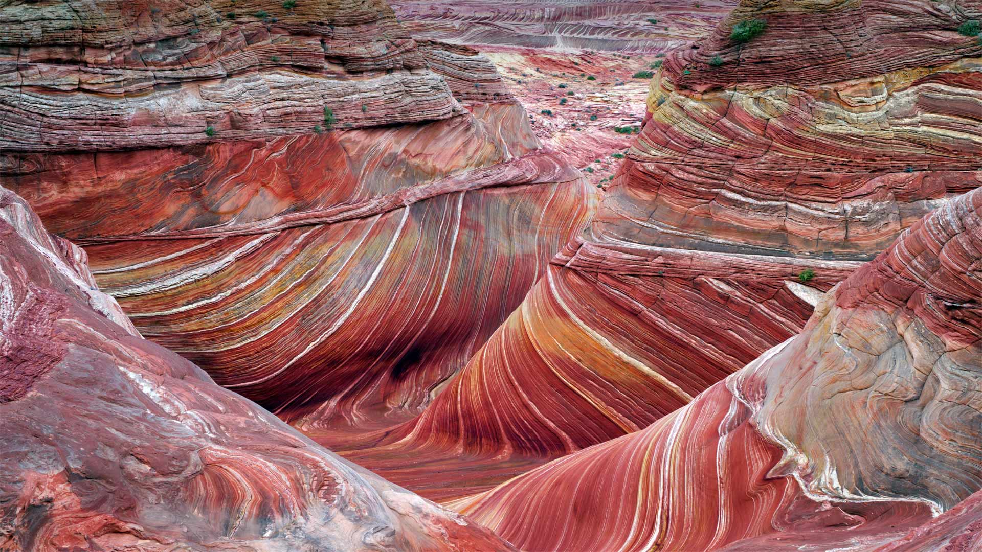
乘风破浪 Ride the wave
The Wave at Coyote Buttes
By showing you this coveted sight, we're saving you a bit of an ordeal. For a close-up view like this of 'The Wave,' a whorled sandstone formation in the northern Arizona wilderness, you'd have to navigate a rugged and mostly trail-free hiking route in typically scorching temperatures. You'd also need to have a permit in your pocket. To protect the landscape, only a small number are available, offered through a daily lottery. But maybe for you the journey is at least as important as the destination? If so, this is just one hike of many in the expansive Paria Canyon-Vermilion Cliffs National Monument, which protects more than 100,000 acres of Arizona and Utah canyonland.
郊狼丘上的波浪
通过向你们展示这一令人垂涎的景象,我们为你们省去了一点磨难。要想近距离拍摄“The Wave”,这是亚利桑那州北部荒野中的一个螺纹砂岩地层,你必须在典型的酷热天气下,沿着崎岖不平、几乎没有足迹的徒步路线行走。你还需要口袋里有许可证。为了保护景观,只有少数人可以通过每日彩票获得。但也许对你来说,旅程至少和目的地一样重要?如果是这样的话,这只是帕里亚峡谷朱红色悬崖国家纪念碑中众多徒步旅行中的一次,该纪念碑保护着亚利桑那州和犹他州超过10万英亩的峡谷地。
科罗拉多河上的马蹄湾,美国亚利桑那州 Horseshoe Bend, Arizona (© Michael Dunn/Getty Images)
科罗拉多河上的马蹄湾,美国亚利桑那州 Horseshoe Bend, Arizona (© Michael Dunn/Getty Images)
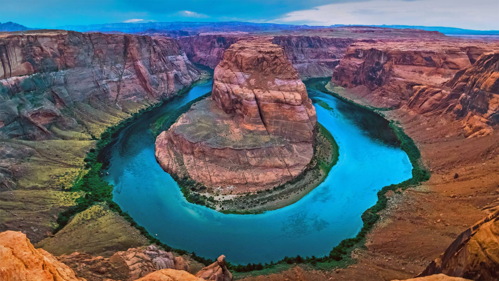
打卡马蹄湾会带来好运吗? Does this horseshoe bring good luck?
Horseshoe Bend, Arizona
Grab your boots and gear, today we're heading to Arizona to hike out to Horseshoe Bend. Known as the 'east rim of the Grand Canyon,' it's actually about 140 miles from the other rims and is really more a part of nearby Glen Canyon. Scientifically, the beautiful view exists thanks to something called an 'entrenched meander.' Around six million years ago, the area was closer to sea level. The Colorado River, following the path of least resistance, meandered and became trapped when the Colorado Plateau uplifted around five million years ago. Over time, the river water cut through exposed sandstone, forming the thousand-foot-deep, 270-degree horseshoe-shaped bend.
Horseshoe Bend used to be a locally loved gem until social media came around to spread photos like this one. Now, nearly two million tourists a year hike to this national splendor. It's believed that, eventually, the Colorado River will cut through the neck of the bend. So, if you want your selfie with the horseshoe, you only have another million years, give or take.
亚利桑那州马蹄湾
带上你们的靴子和装备,今天我们要去亚利桑那州徒步去马蹄弯。它被称为“大峡谷的东边缘”,实际上距离其他边缘约140英里,实际上更像是附近格伦峡谷的一部分。从科学角度讲,这美丽的景色之所以存在,是因为有一种叫做“根深蒂固的曲流”的东西大约600万年前,该地区接近海平面。科罗拉多河沿着阻力最小的路径蜿蜒而行,在大约500万年前科罗拉多高原抬升时陷入困境。随着时间的推移,河水穿过裸露的砂岩,形成了千英尺深、270度马蹄形的弯曲。
马蹄弯曾经是当地人喜爱的珍宝,直到社交媒体开始传播像这样的照片。现在,每年有近200万游客徒步前往这个国家的辉煌。据信,科罗拉多河最终将穿过弯道的颈部。所以,如果你想在马蹄铁上自拍,你只能再活一百万年,不管付出与否。