标签 河 下的文章
泰晤士河,伦敦,英国 River Thames, London, England (© Puthipong Worasaran/Getty Images)

泰晤士河,伦敦,英国 River Thames, London, England (© Puthipong Worasaran/Getty Images)
小船轻轻划过泰晤士河 Row your boat gently down the Thames
泰晤士河节,伦敦
欢迎来到英国伦敦的泰晤士河节。每年,它都会将社区、艺术家和自然爱好者聚集在一起,向河流致敬,为期一个月。2024年的重点活动包括一年一度的帆船赛舟会、大河赛和清洁泰晤士河挑战赛。
泰晤士河是全英格兰最长的河流,沿途有80多个岛屿。从格洛斯特郡开始,蜿蜒穿过牛津、温莎等城市,以及今天的伦敦,流经215英里后与北海汇合。这条河有一系列淡水和近海水栖息地,是疣鼻天鹅和宽吻海豚等野生动物的天堂。它的两侧还分布着多个具有特殊科学价值的景点。因此,在这个月,让河流的潮汐指引你去发现和庆祝吧!
River Thames, London
Welcome to the Totally Thames Festival in London, England. Each year it brings together communities, artists, and nature enthusiasts in a month-long tribute to the river. Highlights for 2024 include the annual boat marathon, Great River Race, and the Clean Thames Challenge.
The Thames, the longest river entirely in England, contains more than 80 islands along its course. Starting in Gloucestershire in southwest England, it winds through cities like Oxford, Windsor, and London, pictured above, flowing for 215 miles before merging with the North Sea on the southeast coast. Once heavily polluted, it is now said to be one of the world's cleanest rivers flowing through a major city and is a haven for an array of wildlife including mute swans and bottlenose dolphins.
罗布森山附近的弗雷泽河,大不列颠哥伦比亚省,加拿大 The Fraser River near Mount Robson, British Columbia, Canada (© phototropic/Getty Images)

罗布森山附近的弗雷泽河,大不列颠哥伦比亚省,加拿大 The Fraser River near Mount Robson, British Columbia, Canada (© phototropic/Getty Images)
时而潺潺细流,时而奔腾咆哮 Trickle, babble, or roar
世界河川日
如果你是一个喜欢大自然的环保倡导者,喜欢听河流的轰鸣声,那么,今天的世界河川日一定不要错过。继2005年至2015年联合国“生命之水”
国际行动十年之后,加拿大保育生物学家马克·安杰洛(Mark
Angelo)提出了一项保护河流的全球性活动。自2005年起,联合国将每年9月的第四个星期日定为世界河川日,旨在关注和保护河流的环境、文化及生态。
今天图片的主角,弗雷泽河,是不列颠哥伦比亚省最长的河流,也是加拿大第11长的河流。这条河的源头位于落基山脉,蜿蜒穿越超过854英里的坡地和平原,最后汇入温哥华以南的乔治亚海峡。
World Rivers Day
If you are a nature enthusiast, or simply enjoy listening to the sound of rumbling rivers, you might like to know that today is World Rivers Day. First held in 2005 during the United Nations' 'Water for Life’ campaign, it was proposed by Canadian river conservationist Mark Angelo, who founded BC Rivers Day in western Canada in 1980. World Rivers Day is held on the fourth Sunday of September to celebrate and raise awareness of the benefits that rivers provide to people and the planet.
The star of today's image, the Fraser River, is the longest river in British Columbia and the 11th longest in Canada. The stream meanders from the Rocky Mountains, traveling more than 850 miles over slopes and flatlands before it merges with the Strait of Georgia, just south of Vancouver.
克罗夫附近的摩泽尔河,德国 Moselle River loop near Kröv, Germany (© Jorg Greuel/Getty Images)
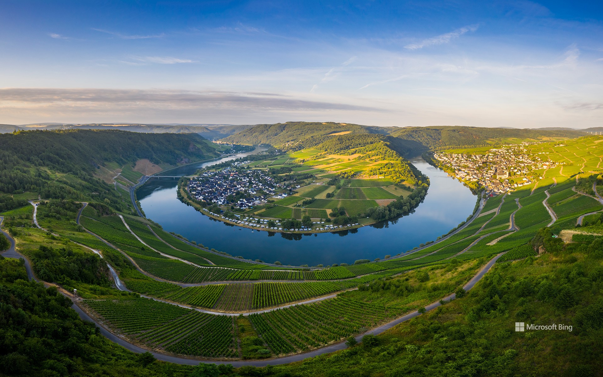
克罗夫附近的摩泽尔河,德国 Moselle River loop near Kröv, Germany (© Jorg Greuel/Getty Images)
河湾 Staying in the loop
克罗夫附近的摩泽尔河,德国
摩泽尔河是奔腾的莱茵河的一条支流,贯穿欧洲迷人的土地,流经法国、卢森堡和德国。河流雕刻出令人惊叹的山谷,两岸点缀着城镇和历史建筑。郁郁葱葱、沐浴阳光的葡萄藤爬满河流两岸的山坡,这里出产一些世界上最优质的葡萄酒,包括雷司令、白皮诺、灰皮诺。缓缓流动、波光粼粼的河水造就了宁静的氛围,吸引游客来此游船休闲或在岸边漫步。摩泽尔河是自然爱好者、葡萄酒爱好者和历史爱好者共同的圣地。
Moselle River loop near Kröv, Germany
The Moselle River, a tributary of the powerful Rhine, meanders through the landscapes of France, Luxembourg, and Germany. Along the way, it carves out valleys of breathtaking natural beauty, dotted with towns and historic landmarks. Lush, sun-drenched vineyards cling to the steep slopes overlooking the river, producing some of the finest wines in the world, including riesling, pinot blanc, and pinot gris, to name a few. The river's gentle flow and sparkling waters invite visitors to embark on leisurely cruises or peaceful walks along its shores. The Moselle creates a haven for nature lovers, wine enthusiasts, and history buffs alike.
斯太尔河, 奥地利 Steyr River, Austria (© guenterguni/Getty Images)

斯太尔河, 奥地利 Steyr River, Austria (© guenterguni/Getty Images)
大自然的蓝色奇观 Nature's blue wonder
斯太尔河,奥地利
今天这张照片并未经过调色,奥地利斯太尔河的水真的就是这般湛蓝。斯太尔河流经托特斯山脉,当地植被稀少,那为什么斯太尔河还能如此清澈湛蓝?答案就在环绕斯太尔河谷的群山之中。雨水和融化的雪水流入斯太尔河后,其中较重的沉积物沉到水底,而较细的沉积物则会悬浮在水中。被沉积物散射或反射的阳光就赋予了河水这样鲜艳的蓝色。
Steyr River, Austria
These whitewater rapids are found in Upper Austria, where the Steyr River crashes down from the barren Totes Gebirge (the Dead Mountains) through this verdant landscape. When it comes to the ancient town of Steyr, at the foot of the Alps, it will meet the Enns River, which flows into the Danube.
What gives the Steyr that stunning blue hue? The answer is found in the mountains themselves. When there's rainfall or the surrounding snow melts, eroded sediment flows into the river. Heavier sediment sinks to the bottom and finer sediment stays suspended in the water. Sunlight is scattered or reflected by the sediment, allowing us to see a vibrant shade of blue, as the Steyr crashes through this lush landscape.
横贯图尔库的奥拉河, 芬兰 Aura River in Turku, Finland (© Jarmo Piironen/Alamy)

横贯图尔库的奥拉河, 芬兰 Aura River in Turku, Finland (© Jarmo Piironen/Alamy)
奥拉河,图尔库,芬兰
图尔库大教堂矗立在奥拉河口附近的霜冻森林之上。这座大教堂最初是在13世纪晚期用木头建造的,并在14世纪和15世纪使用石头作为主要建筑材料进行了扩建。事实证明这是明智的选择,因为1827年的图尔库大火灾吞噬了这座城市的大部分地区,也对大教堂造成严重损坏。数年后,这座教堂再次迎来了重建。
Aura River in Turku, Finland
The Turku Cathedral rises above the frosted forests near the mouth of the Aura River, which runs through the middle of Turku, Finland.
Originally built out of wood in the late 13th century, the cathedral was expanded in the 14th and 15th centuries, mainly using stone as construction material. This would prove wise, as the Great Fire of Turku consumed much of the city in 1827 and badly damaged the cathedral. It was rebuilt over the next few years.
犹他州锡安国家公园的维尔京河,美国 Virgin River in Zion National Park, Utah (© Jonathan Ross/Getty)

犹他州锡安国家公园的维尔京河,美国 Virgin River in Zion National Park, Utah (© Jonathan Ross/Getty)
锡安国家公园的维珍河
我们的照片将我们带到16英里长的维珍河,在那里它穿过犹他州锡安峡谷上游,形成了一个壮观的千英尺深的峡谷。流经锡安国家公园(今天已满103岁!),由于科罗拉多高原、大盆地和莫哈韦沙漠交汇处的独特生物群落,维珍河是其他地方所没有的独特植物和动物的家园。如果没有维珍河水系的水,像世界上最稀有的物种之一的wondfin小鱼这样的生物就不可能存在。
Virgin River in Zion National Park
Our photo brings us to a 16-mile stretch of the Virgin River where it cuts a spectacular thousand-foot-deep gorge through the upper reaches of Utah's Zion Canyon. Flowing through Zion National Park (which turns 103 today!), the Virgin River is home to unique plants and animals that aren't found anywhere else, due to the unique intersection of biomes found where the Colorado Plateau, Great Basin, and Mojave Desert all meet. Without the water of the Virgin River system, creatures like the woundfin minnow, one of rarest species on the planet, couldn't exist.
凯恩戈姆斯的奎奇河上的圆形凹地, 苏格兰阿伯丁郡凯恩戈姆斯 Punch Bowl on the River Quoich in the Cairngorms, Aberdeenshire, Scotland (© AWL Images/Danita Delimont)
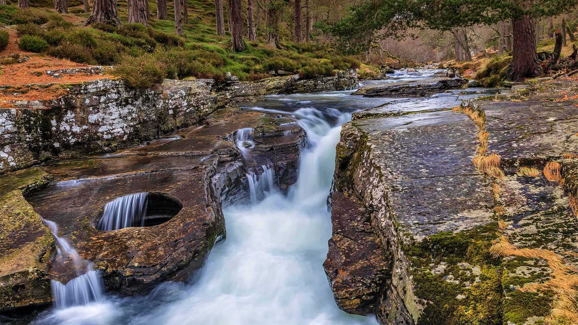
凯恩戈姆斯的奎奇河上的圆形凹地, 苏格兰阿伯丁郡凯恩戈姆斯 Punch Bowl on the River Quoich in the Cairngorms, Aberdeenshire, Scotland (© AWL Images/Danita Delimont)
从大酒钵里喝一口 Take a sip from the Punchbowl
苏格兰阿伯丁郡的奎奇河
在苏格兰东部高地,一条小而受人喜爱的河流蜿蜒在凯恩戈姆山脉的森林高原上,流经一条峡谷。奎伊奇河是自然爱好者、徒步旅行者和勇敢的划桨者经常光顾的地方,他们愿意勇敢地面对它惊人的湍急水流和几处瀑布,其中就包括这里的奎伊奇林。这些瀑布以你在图片左侧看到的岩石中的碗状空洞而闻名。
这一被称为“Punch Bowl”的自然景观已成为那些游览河流并沿着河岸徒步3英里的游客的明星景点。据传说,拥有这些森林的18世纪贵族马尔伯爵会在洞顶上放一个仪式用的冲头碗,在成功猎鹿后从中喝水。英国在位时间最长的君主维多利亚女王也经常光顾这些松林,并在瀑布附近建了一座现已废弃的小屋。虽然奎奇河的美丽适合女王,但你不必成为皇室成员就可以享受它。
River Quoich in Aberdeenshire, Scotland
In the eastern Highlands of Scotland, tucked into the forested plateaus of the Cairngorms mountain range is a small but beloved river that runs through a ravine. The River Quoich is frequented by nature lovers, hikers, and intrepid paddlers willing to brave its surprisingly swift currents and its several waterfalls, including the one featured here, the Linn of Quoich. These falls are famous for the bowl-shaped cavity in the rock that you see on the left side of this image.
Called the Punch Bowl, this natural feature has become the star attraction for those who visit the river and take the 3-mile hike along its banks. According to lore, the Earl of Mar, the 18th-century nobleman who owned these woods, would place a ceremonial punch bowl atop the hole and drank from it after a successful deer hunt. Queen Victoria, Britain's longest-reigning monarch, also frequented these pine woods and built a now derelict lodge near the falls. While the beauty of the River Quoich is fit for a queen, you don't have to be royalty to enjoy it.
伊萨尔河鸟瞰图,德国伦格里斯 (© Martin Siepmann/Offset/Shutterstock)
两头穿越苏西特纳河的驯鹿,美国阿拉斯加 Caribou crossing the Susitna River during the autumn rut, Alaska (© Tim Plowden/Alamy)
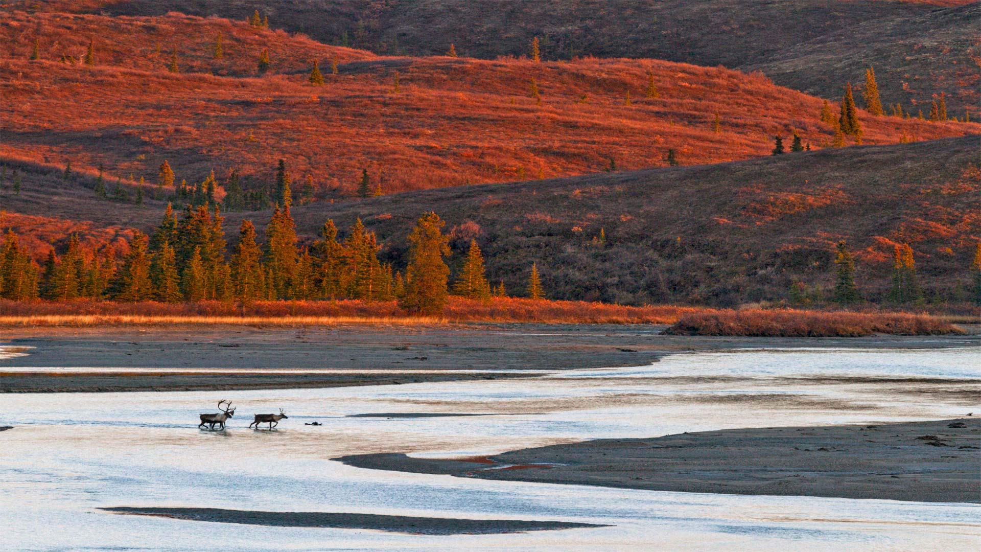
两头穿越苏西特纳河的驯鹿,美国阿拉斯加 Caribou crossing the Susitna River during the autumn rut, Alaska (© Tim Plowden/Alamy)
令人印象深刻的时刻 Time to make an impression
Caribou rutting season in Alaska
It's that time of year when Alaskan caribou are beginning to feel a little frisky. From late September until early November, males will be strutting their stuff, locking antlers with one another, and competing for the attention of females in hopes of furthering the species. Successful males will mate with 15-20 females a season. After the rutting season males will shed their antlers while females keep theirs until spring. In today's photo we're looking at some caribou in southcentral Alaska crossing the Susitna River.
Alaska has 32 distinct caribou herds. It's likely today's caribou are members of the Nelchina herd, which roams across about 20,000 square miles in the high basin surrounded by the Talkeetna, Chugach, Wrangell, and Alaska ranges. The Nelchina herd is among the most studied and recognized of Alaskan caribou partly because their range is relatively close to the major human population centers of the state. The herd has provided food for Alaskans for hundreds of years and its population is maintained through carefully monitored hunting regulations. But caribou populations can fluctuate from one year to the next depending on the availability of food and severity of the weather.
阿拉斯加驯鹿发情季节
每年的这个时候,阿拉斯加驯鹿开始感到有点活泼。从9月下旬到11月初,雄性将昂首阔步,相互锁住鹿角,争夺雌性的注意力,以期进一步丰富物种。成功的雄性每季度将与15-20只雌性交配。发情期过后,雄性会脱掉鹿角,而雌性会一直保留到春天。在今天的照片中,我们看到一些驯鹿在阿拉斯加中南部穿越苏西特纳河。
阿拉斯加有32个不同的驯鹿群。今天的北美驯鹿很可能是Nelchina鹿群的成员,它们在塔基特纳山脉、楚加赫山脉、朗格尔山脉和阿拉斯加山脉环绕的高盆地中漫游,占地约20000平方英里。Nelchina驯鹿群是阿拉斯加驯鹿中研究和认识最多的驯鹿群之一,部分原因是它们的分布范围相对接近该州的主要人口中心。数百年来,牧群一直为阿拉斯加人提供食物,通过仔细监测狩猎法规来维持种群数量。但是驯鹿的数量可能会随着食物的供应和天气的恶劣程度而在一年到另一年之间波动。
亚马逊河鸟瞰图,巴西 Aerial view of the Amazon River in Brazil (© Curioso.Photography/Shutterstock)
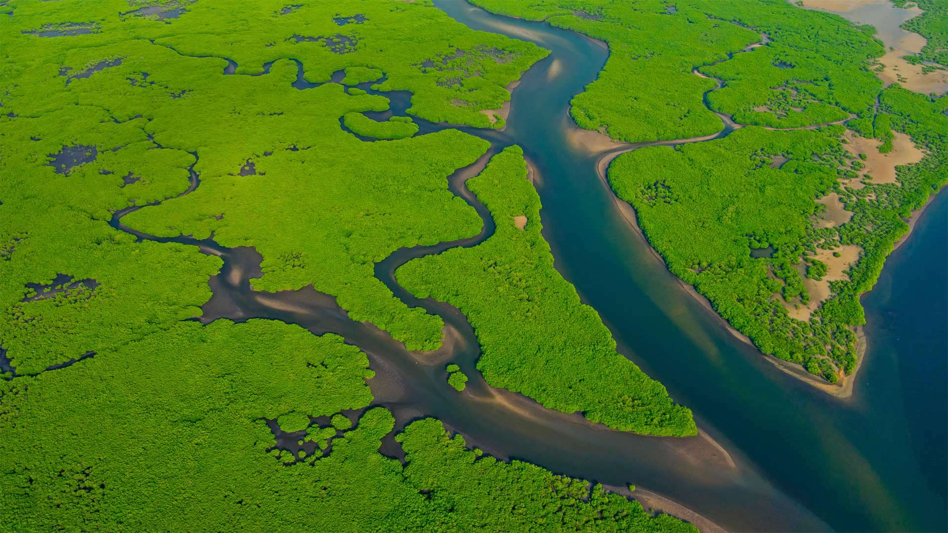
亚马逊河鸟瞰图,巴西 Aerial view of the Amazon River in Brazil (© Curioso.Photography/Shutterstock)
匆匆而逝的河流 The rivers run through us
World Rivers Day
On World Rivers Day, we honor what may be thought of as the queen of them all—the Amazon, which flows more than 4,000 miles mostly through the South American countries of Peru and Brazil. The Amazon discharges a whopping 58 million gallons of fresh water into the ocean every second, enough to fill 83 Olympic-sized swimming pools, far more water than any other river in the world. It accounts for 20% of all fresh water that flows into the world's seas and oceans. It's also the vital heart of the largest and most diverse rain forest in the world—the Amazon Rain Forest is home to a third of the world's animal species and its trees and plants pull billions of tons of heat-trapping carbon dioxide from the atmosphere each year, making it one of the Earth's best defenses against climate change.
Mark Angelo, a river conservationist from British Columbia, launched World Rivers Day in 2005 to recognize the importance of rivers to the survival of humanity and millions of species all over the world. Rivers are our best source of fresh water, they can be an important energy source, they're the foundations of complex ecosystems, and provide crucial sources of irrigation for our crops, among other contributions to our way of life. Besides, who doesn't love a float down a lazy river?
世界河流日
在世界河流日,我们向可能被认为是所有河流中的女王的亚马逊河致敬,该河流经4000多英里,主要流经南美国家秘鲁和巴西。亚马逊河每秒向海洋排放5800万加仑的淡水,足以填满83个奥运会规模的游泳池,远远超过世界上任何其他河流。它占流入世界海洋的所有淡水的20%。亚马逊雨林是世界上最大、种类最多的雨林的重要心脏,是世界三分之一动物物种的家园,其树木和植物每年从大气中吸收数十亿吨的吸热二氧化碳,使其成为地球抵御气候变化的最佳防御措施之一。
来自不列颠哥伦比亚省的河流保护主义者马克·安吉洛(Mark Angelo)于2005年发起了世界河流日活动,以认识到河流对全世界人类和数百万物种生存的重要性。河流是我们最好的淡水来源,它们可以是重要的能源,是复杂生态系统的基础,为我们的作物提供重要的灌溉资源,以及对我们生活方式的其他贡献。此外,谁不喜欢沿着懒惰的河流漂流?