标签 鸟瞰 下的文章
大沼泽地国家公园的鸟瞰图,佛罗里达州,美国 Aerial view of Everglades National Park, Florida (© Robert DelVecchio - OcuDrone/Getty Images)
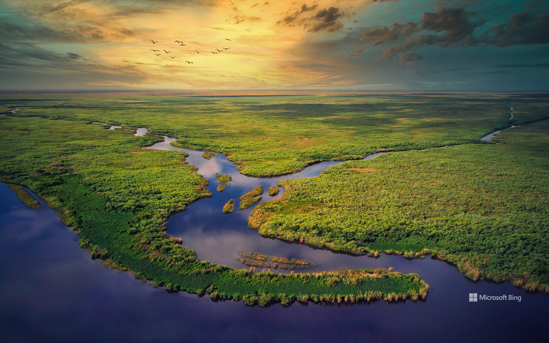
大沼泽地国家公园的鸟瞰图,佛罗里达州,美国 Aerial view of Everglades National Park, Florida (© Robert DelVecchio - OcuDrone/Getty Images)
草之河流 A river of grass
大沼泽地国家公园,佛罗里达州
我们是否曾设想,从高空俯瞰自身在这片广袤水域中的倒影?佛罗里达州的大沼泽地国家公园是美国最大的热带荒野,面积超过150万英亩。它保护了原始大沼泽地的南部20%,栖息着众多珍稀和濒危物种,包括佛罗里达美洲豹、美洲鳄以及西印度海牛。大沼泽地国家公园被称为“草之河”,其独特的生态系统由从奥基乔比湖缓慢流向佛罗里达湾的河流供养,是热带涉禽的重要繁殖地。这座国家公园不仅是美国的自然瑰宝,也具有重要的国际价值。它被联合国教科文组织列为世界遗产、国际生物圈保护区以及国际重要湿地。
大沼泽地公园在水资源保护与防洪调蓄方面也发挥着至关重要的作用,其湿地系统如同天然过滤器,同时也是抵御风暴侵袭的重要缓冲区。当前,针对大沼泽地的保护与生态修复工作仍在持续推进,涵盖多个方面,包括应对入侵物种、改善水质及保护野生动物栖息地等关键举措。
Everglades National Park, Florida
Wouldn't it be great to see our reflection from above in this vast expanse of water? Everglades National Park, located in Florida, is the largest tropical wilderness in the US, spanning more than 1.5 million acres. It protects the southern 20% of the original Everglades and is home to numerous rare and endangered species, including the Florida panther, American crocodile, and West Indian manatee. Often referred to as the 'River of Grass,' the park's unique ecosystem, fed by a slow-moving river from Lake Okeechobee to Florida Bay, is a significant breeding ground for tropical wading birds. Everglades National Park is not only a national treasure but also an international one, recognized as a World Heritage Site, an International Biosphere Reserve, and a Wetland of International Importance.
The park also plays a crucial role in water conservation and flood control, as its wetlands serve as natural filters and buffers against storms. Efforts to preserve and restore the Everglades are ongoing, with numerous initiatives aimed at combating invasive species, improving water quality, and protecting wildlife habitats.
日出时分,美丽的喀斯特山脉鸟瞰图,中国桂林 Aerial view of beautiful karst mountains at sunrise, Guilin, China (© zhaojiankang/Getty Images)
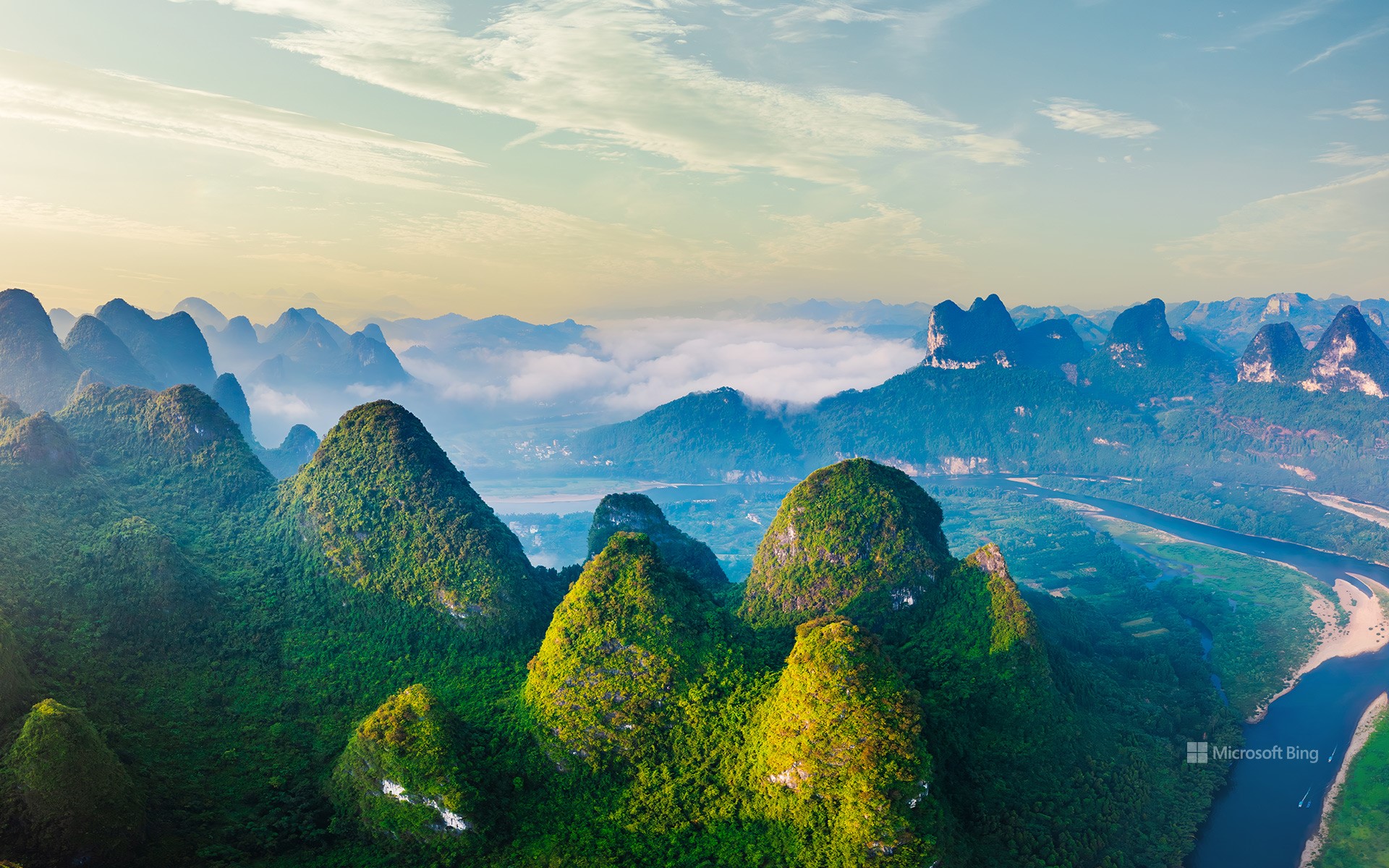
日出时分,美丽的喀斯特山脉鸟瞰图,中国桂林 Aerial view of beautiful karst mountains at sunrise, Guilin, China (© zhaojiankang/Getty Images)
秀美壮丽的山河 Beautiful and magnificent mountains and rivers
喀斯特山脉,广西桂林,中国
今天是立夏,标志着我们即将进入夏季,今天图片中壮丽又秀美的山河景色是位于中国桂林的喀斯特山脉景致。桂林喀斯特地貌,位于广西南岭构造带中部,是大陆型塔状岩溶的典型代表,华南地区岩溶演化末期的地貌展现,世界地质遗产地。桂林喀斯特位于南岭构造带中部,以秀美漓江及其支流周边的塔状及锥状岩溶地貌为主要特征,同时发育有许多洞穴。受古生代构造运动的影响,桂林喀斯特形成了独特的岩溶发育盆地。
这里的山水如同一幅幅精美的山水画卷,吸引着来自世界各地的游客。它是中国山水画的真实写照来到桂林,你会被这里的美景所陶醉,仿佛置身于一幅幅山水画中,感受着大自然的瑰丽与壮美。
冰岛冰川河流鸟瞰图 Aerial view of glacial rivers in Iceland (© rybarmarekk/Shutterstock)
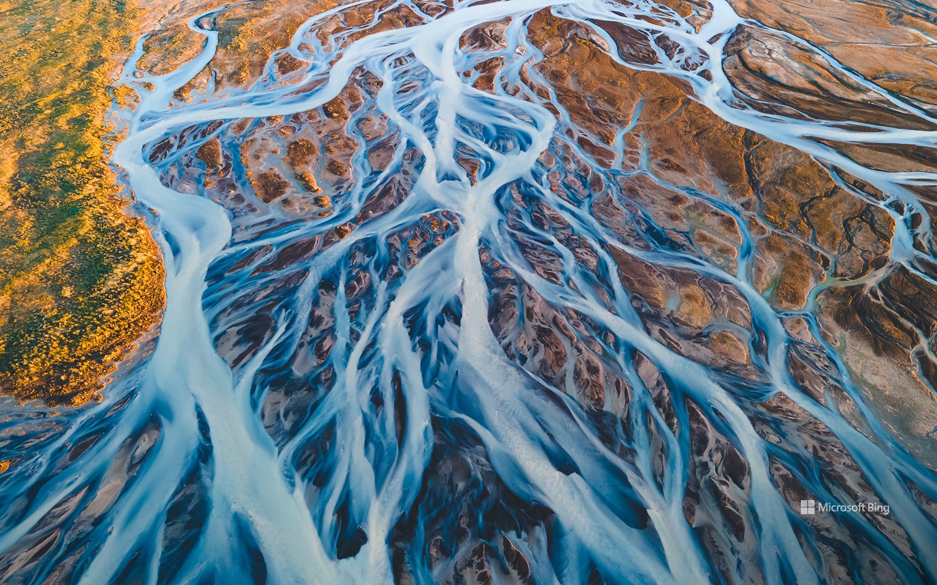
冰岛冰川河流鸟瞰图 Aerial view of glacial rivers in Iceland (© rybarmarekk/Shutterstock)
来自冰与火之国 From the land of fire and ice
冰川河流,冰岛
“冰与火之国”冰岛的冰川河流在数千年的时间里塑造了冰岛的地貌。今天图片中的河流就是由瓦特纳、朗格和霍夫斯等巨大冰川的融水形成的。瓦特纳冰川是冰岛第一大冰川,覆盖面积超3000平方英里,约占冰岛国土面积10%。冰川融化后,冰川水携带着细小的沉积物,形成了乳白色的辫状河流系统,与火山地形的泥土色调形成鲜明对比。每年春夏季节,河流都会因季节性融水而激增,不断塑造和重塑这片土地。从空中俯瞰,可以看到它们错综复杂的图案,就像一幅幅复杂的艺术品,在地形上交织着向北大西洋延伸。冰岛的水不仅仅是一道美丽的风景,它在可再生能源方面也发挥着重要作用。水流为水电站提供动力,巩固了冰岛作为可持续能源领导者的地位。
Glacial rivers in Iceland
Iceland's glacial rivers have shaped the landscape here in the land of fire and ice over thousands of years. The rivers seen in today's image are formed from the meltwater of vast glaciers like Vatnajökull, Langjökull, and Hofsjökull. Vatnajökull, the largest ice cap in Iceland, covers over 3,000 square miles—approximately 10% of the country's landmass. As the glaciers melt, the water carries fine sediments, creating a braided river system with a milky appearance that contrasts with the earthy tones of the volcanic terrain. Every spring and summer, the rivers swell with seasonal meltwater, continually shaping and reshaping the land. Aerial views reveal their intricate patterns, interwoven across the terrain toward the North Atlantic Ocean. The water also powers hydroelectric power stations, reinforcing Iceland's status as a leader in sustainable energy.
秋季葡萄园的鸟瞰图,瓦恩哈尔特,黑森林,德国 Aerial view of vineyards in autumn, Varnhalt, Black Forest, Germany (© Sabine Gerold/Amazing Aerial Agency)
秋季葡萄园的鸟瞰图,瓦恩哈尔特,黑森林,德国 Aerial view of vineyards in autumn, Varnhalt, Black Forest, Germany (© Sabine Gerold/Amazing Aerial Agency)
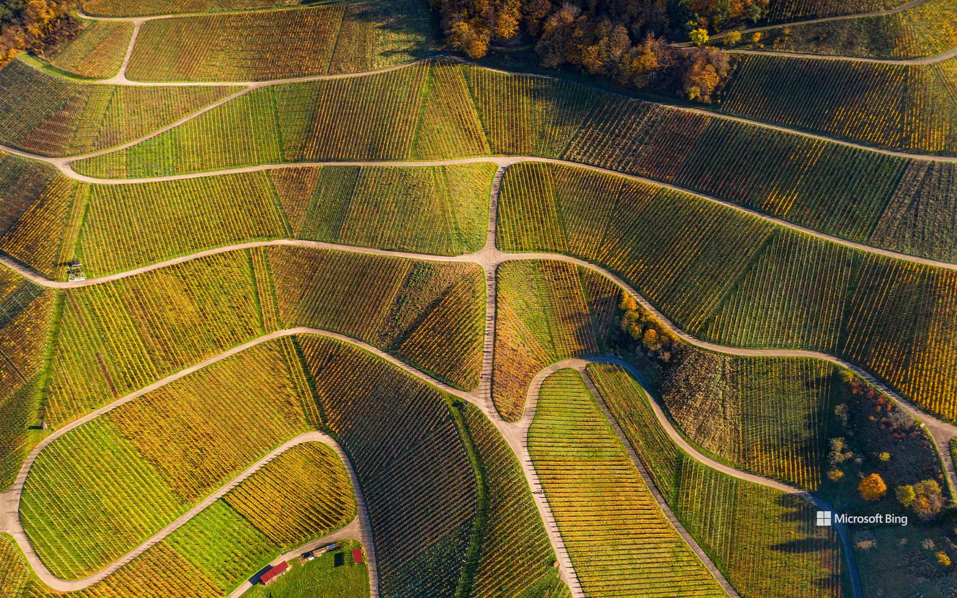
引以为豪的传统 A proud heritage
瓦恩哈尔特的葡萄园,黑森林,德国
巴登葡萄酒之路是一条风景如画的路线,它沿着黑森林绵延500多公里,穿过德国最美丽的葡萄种植区。在今天的图片中,我们来到了隶属于巴登-巴登的迷人的葡萄酒村瓦恩哈尔特。该地区的亮点之一是纳格尔斯福斯特酒庄。这个酒庄自1588年开始运营,以生产雷司令葡萄酒而闻名,其葡萄酒以品质卓越而著称。
瓦恩哈尔特与施泰因巴赫以及诺伊韦尔一样,都有一个独特而迷人的传统:自18世纪以来,这些村庄就拥有了用“圆扁瓶”装瓶的罕见特权。维尔茨堡主教授予的这一权利让该地区变得与众不同,因为它是德国除弗兰肯以外,少数几个允许使用这种瓶型的地方之一。“圆扁瓶”强调葡萄酒的独特性和高品质,自1989年以来,这一瓶型在欧盟一直受到了特殊的商标保护。无论你是葡萄酒爱好者还是历史爱好者,瓦恩哈尔特都能让你一睹葡萄酒酿造世界的迷人风采。
法属波利尼西亚波拉波拉岛的鸟瞰图 (© GLF Media/Shutterstock)
法属波利尼西亚波拉波拉岛的鸟瞰图 (© GLF Media/Shutterstock)
梦想成真的地方
波拉波拉岛,法属波利尼西亚
想象一下,碧蓝的海水与洁白的沙滩交相辉映,苍翠的群山拥抱着蔚蓝的天空。欢迎来到法属波利尼西亚的明珠波拉波拉岛。从塔希提法阿国际机场乘坐50分钟的飞机即可到达,这里是一片天堂,大自然是这里的主宰者。
在泻湖潜水、观赏蝠鲼和五彩斑斓的鱼类之后,可以在著名的玛提拉海滩放松休息,这里完美得像明信片上的风景。喜欢冒险的人可以参加导游带领的徒步旅行,探索奥特马努山,而寻求放松的人则可以在豪华水疗中心享受波利尼西亚按摩。
波拉波拉岛不仅仅是一个目的地,它更是一种感官体验,每时每刻都能让你与大自然亲密接触。无论你是在寻找蜜月旅行、浪漫假期还是健康度假的目的地,这个天堂般的岛屿都能为您提供理想的环境,留下难忘的回忆。
大运河和安康圣母教堂的鸟瞰图,威尼斯,意大利 Aerial view of the Grand Canal and the Basilica di Santa Maria della Salute, Venice, Italy (© Bachir Moukarzel/Amazing Aerial Agency)
大运河和安康圣母教堂的鸟瞰图,威尼斯,意大利 Aerial view of the Grand Canal and the Basilica di Santa Maria della Salute, Venice, Italy (© Bachir Moukarzel/Amazing Aerial Agency)
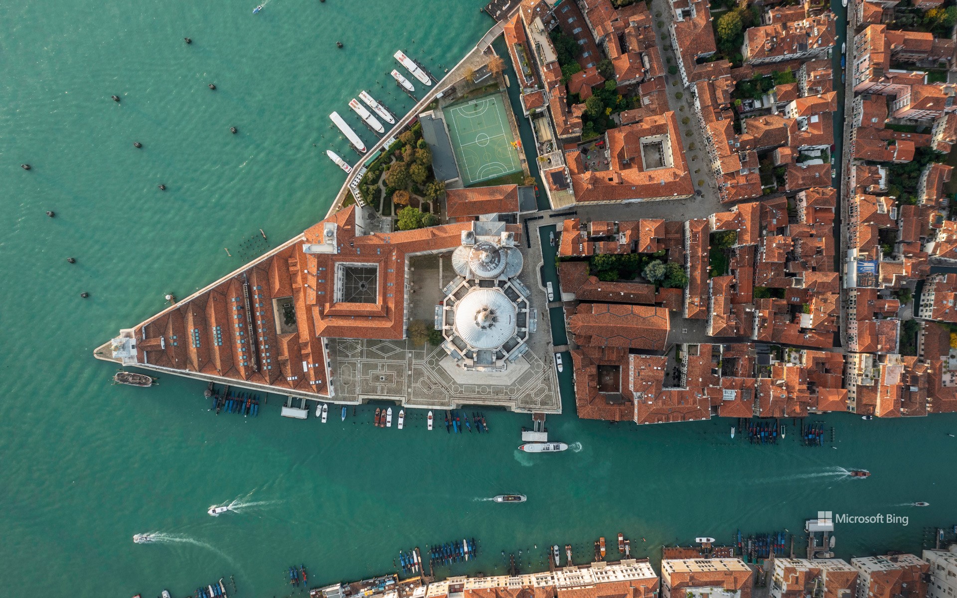
在漂浮的城市之上 Above the floating city
安康圣母教堂,威尼斯,意大利
威尼斯的安康圣母教堂历史悠久,是巴洛克建筑风格的典范。这座教堂建于1631年至1687年,是为了纪念1630年威尼斯从一场毁灭性瘟疫中解脱出来。教堂建在大运河的入口处,其圆顶在威尼斯的天际线上占据着主导地位,正如今天的图片所示。意大利建筑师巴尔达萨雷·隆盖纳在26岁时就构思了这座建筑,它成为了隆盖纳毕生的事业,并在他去世后完工。教堂外部的涡卷状装饰和雕像与宽敞的八角形内部形成鲜明对比,内部装饰着文艺复兴时期艺术家提香和丁托列托的作品。每年11月,威尼斯都会在圣母节期间纪念这座教堂的重要意义,这是一场文化庆祝活动,内容包括节日游行和献蜡烛等,以感谢圣母将人类从瘟疫中解救出来。
Basilica of Santa Maria della Salute, Venice, Italy
The Santa Maria della Salute church in Venice is steeped in history. As a plague devastated the city in 1630, its leader, Doge Nicolò Contarini, vowed to build a majestic church dedicated to the Virgin Mary if the city was spared. In 1631 the epidemic ended, and construction began. The church, built in the Baroque style, was completed around 50 years later, a lifelong project for architect Baldassare Longhena.
Built at the entrance to the Grand Canal, its dome dominates the Venice skyline. Each November, Venice commemorates the church's significance during the Festa della Madonna della Salute, a cultural celebration that includes festive processions and offering of candles in gratitude for deliverance from the plague.
海洋城日出时的鸟瞰图,马里兰州,美国 Aerial view of Ocean City, Maryland, at sunrise (© Kevin Olson/Amazing Aerial Agency)
海洋城日出时的鸟瞰图,马里兰州,美国 Aerial view of Ocean City, Maryland, at sunrise (© Kevin Olson/Amazing Aerial Agency)
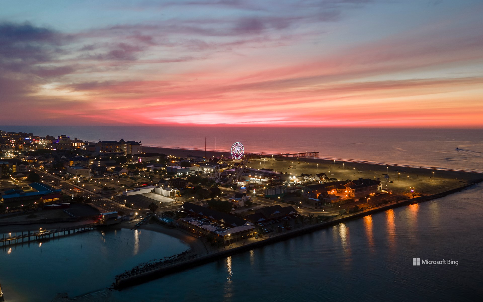
晨曦之光 The morning glow
海洋城日出时的鸟瞰图,马里兰州,美国
欢迎来到海洋城!这是一个美丽的海滨度假胜地,为游客提供无尽的乐趣和冒险。在1875年之前,这里只是一个安静的渔村。同年,大西洋酒店开业,标志着该镇转型为一个新兴的度假胜地。时光荏苒,如今,海洋城是美国最受欢迎的度假胜地之一,为各年龄段的游客提供丰富多样的娱乐活动。该镇有一段标志性的3英里长的木板路,两旁遍布餐厅、商店和游乐园。绵延10英里的纯净沙滩非常适合晒日光浴、打沙滩排球或堆沙堡,而海水则适合畅游。海洋城拥有丰富的娱乐探险活动和深厚的历史底蕴,是一个迷人的休闲胜地,吸引着游客一次又一次前来游玩。
Ocean City, Maryland, at sunrise
Here is a beautiful coastal getaway offering endless fun and adventure—welcome to Ocean City, Maryland. Ocean City was a quiet fishing village until 1875, when the Atlantic Hotel opened its doors, marking the town's transformation into a burgeoning resort destination. Today, it is a popular vacation spot, with an iconic 3-mile-long boardwalk lined with restaurants, shops, and amusement parks. Pristine sandy beaches stretching over 10 miles are perfect for sunbathing, beach volleyball, or building sandcastles, and the ocean waters beckon for a refreshing swim. Ocean City is a charming retreat that draws visitors back time and again.
丘伦梅鲁瀑布鸟瞰图,委内瑞拉 Aerial view of Churun-Meru (Dragon) waterfall, Venezuela (© AirPano LLC/Amazing Aerial Agency)
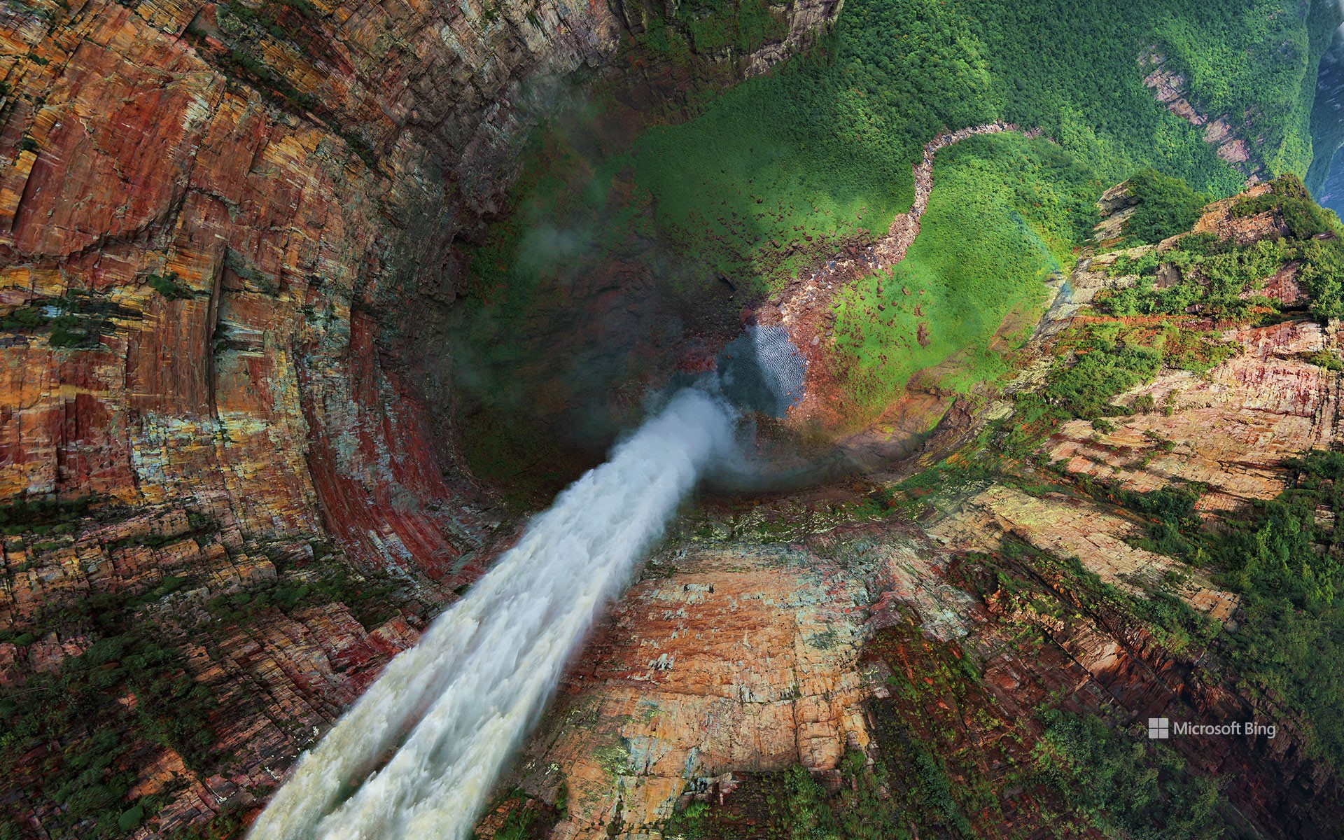
丘伦梅鲁瀑布鸟瞰图,委内瑞拉 Aerial view of Churun-Meru (Dragon) waterfall, Venezuela (© AirPano LLC/Amazing Aerial Agency)
把梦想变成现实! Don't just dream it, stream it!
龙瀑布,委内瑞拉
在荒野的中心地带,一个令人敬畏的景象从山上倾泻而下,这就是委内瑞拉的丘伦梅鲁瀑布!该瀑布也被称为龙瀑布,位于奥扬特普伊山峡谷南端的一个狭长地带,在雨季会与一条邻近的溪流相连。今天的图片展示的正是丘伦梅鲁瀑布从约1300英尺的高处倾泻而下。委内瑞拉拥有一些令人印象深刻的世界自然奇观,其中包括地球上最高的瀑布,也就是位于丘伦梅鲁以南约4英里处的天使瀑布。詹姆斯·安吉尔发现了天使瀑布,但人们常常误以为他发现了龙瀑布,佐证这一说法的证据是天使瀑布常常被误认为是龙瀑布。因此,无论您是在寻找天使瀑布还是龙瀑布,委内瑞拉都有适合您的瀑布!
Churún Merú waterfall in Venezuela
In the heart of the wilderness, an awe-inspiring sight plummets from a mountain—the Churún Merú waterfall in Venezuela. Also known as Dragon Falls, the cascade featured in today's image is in a narrow niche at the southern end of the canyon that divides the mountain of Auyán-tepui. Falling from around 1,300 feet, Churún Merú is joined by a neighboring stream in the wet season. Venezuela is home to some of the world's most impressive natural wonders, including the highest waterfall on Earth, Angel Falls, found some 4 miles south of Churún Merú. So, whether you're after angels or dragons, Venezuela has a waterfall for you!
小红鹳飞越马加迪湖, 肯尼亚 Lesser flamingos flying over Lake Magadi, Kenya (© Vicki Jauron, Babylon and Beyond Photography/Getty Images)
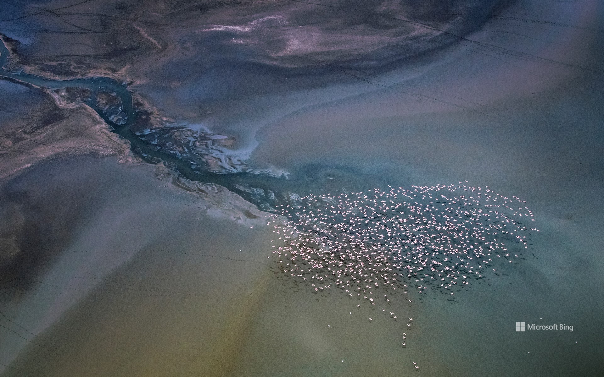
小红鹳飞越马加迪湖,肯尼亚 Lesser flamingos flying over Lake Magadi, Kenya (© Vicki Jauron, Babylon and Beyond Photography/Getty Images)
鸟瞰 Bird's-eye view
马加迪湖,肯尼亚
多么不可思议的景色啊!这张航拍照片展示了以肯尼亚马加迪湖为背景的小红鹳群。小红鹳是六种火烈鸟之一,以其鲜艳的粉红色羽毛和独特的觅食行为而闻名。由于喙的构造,这些鸟喜欢在水面附近进食。它们主要栖息在碳酸盐浓度较高的非洲苏打湖。马加迪湖就是这样一个充满蓝藻和海藻的苏打湖,为火烈鸟提供了充足的营养。成千上万只火烈鸟聚集在湖边的壮观景象揭示了这些独特生态系统的重要性。
Lake Magadi, Kenya
What an unearthly view! This aerial photograph shows a flamboyance of lesser flamingos against the backdrop of Lake Magadi in Kenya. The lesser flamingo is one of six species of flamingo, a bird known for its vibrant pink plumage and distinctive feeding behavior. They use their specialized beaks to filter algae near the water's surface and are often found in African soda lakes like Lake Magadi, which are brimming with cyanobacteria and algae for them to eat. The spectacle of thousands of these avian wonders congregating at the lake reveals the importance of these unique ecosystems.