标签 山脉 下的文章
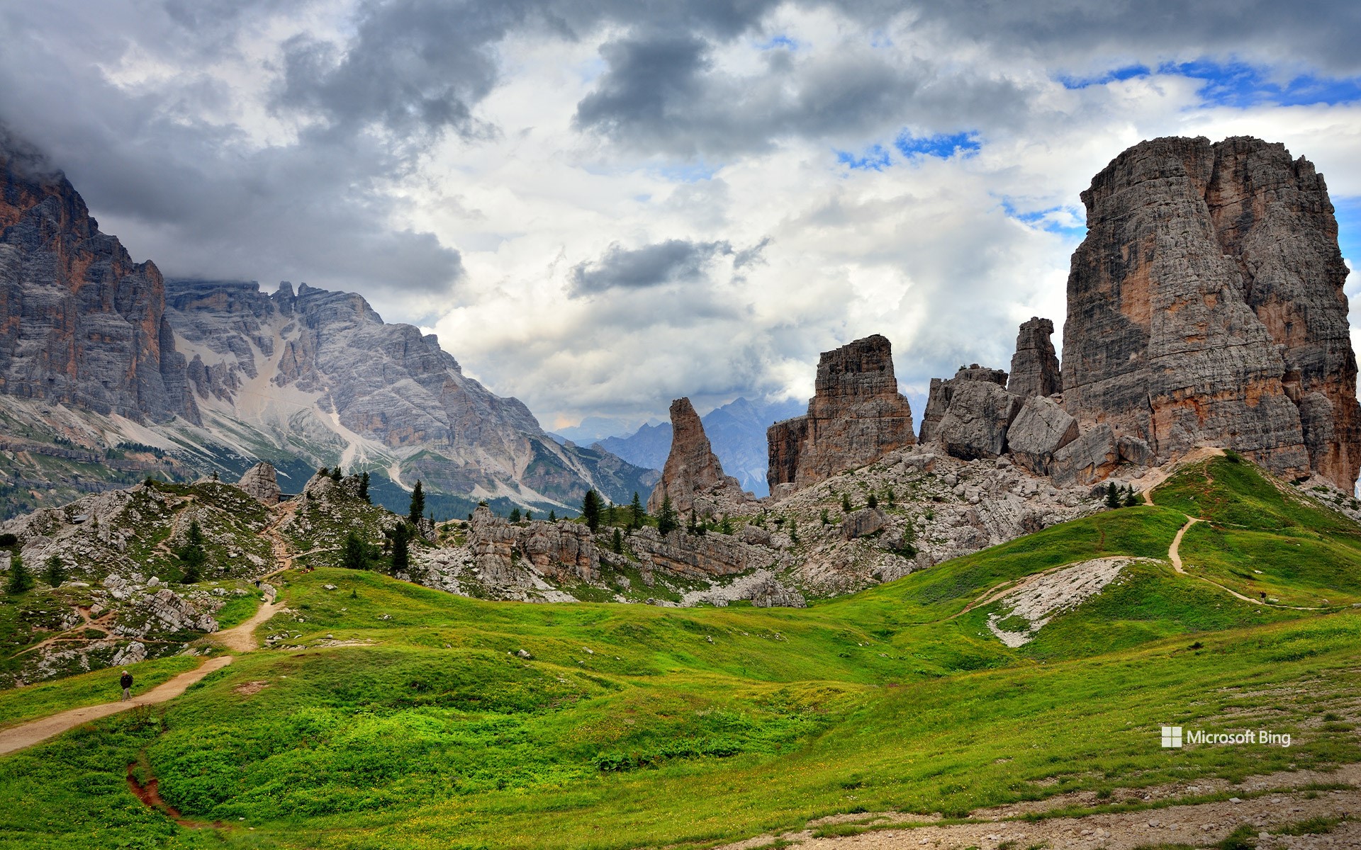
五塔峰,多洛米蒂山脉,科尔蒂纳丹佩佐,贝卢诺省,意大利威尼托大区 Cinque Torri, Dolomites, Italy (© usabin/Getty Images)
五塔峰,多洛米蒂山脉,科尔蒂纳丹佩佐,贝卢诺省,意大利威尼托大区 Cinque Torri, Dolomites, Italy (© usabin/Getty Images)
静谧之声 The sounds of quiet
多洛米蒂山脉五塔峰,意大利
五塔峰坐落于意大利威尼托大区贝卢诺省的多洛米蒂山脉腹地,仿佛天然雕塑般矗立,是夏季避暑、远离海滩与城市喧嚣的理想之选。每一座岩塔皆承载着独特的历史与自然故事:从古文明的遗迹,到徒步与登山者的足迹,再到第一次世界大战时期的军事要地。这些塔峰在战时曾扮演战略要塞的角色,如今游客仍可探访战壕遗址与战争留下的痕迹。然而,自然的力量终将超越人类历史:茂密松林、芳草牧场与山间溪流共同构成了一幅宁静和谐的生态图景,晴朗的天空与繁花草甸相映成趣,伴随着阵阵鸟鸣,为前行的每一步增添生机。
漫步在五塔之间,便是呼吸自由与新鲜空气,在群山静谧中倾听内心。无论你是在攀登、拍照,还是静静沉思,这个地方为游客提供了一个重新发现自我与自然联系的契机。在这里,时间仿佛放慢了脚步,灵魂得以舒展,而自然之美则以沉稳而恒久的姿态,讲述着群山间的故事。
奇索斯山脉,大弯国家公园,德克萨斯州,美国 Chisos Mountains, Big Bend National Park, Texas (© Dean Fikar/Getty Images)
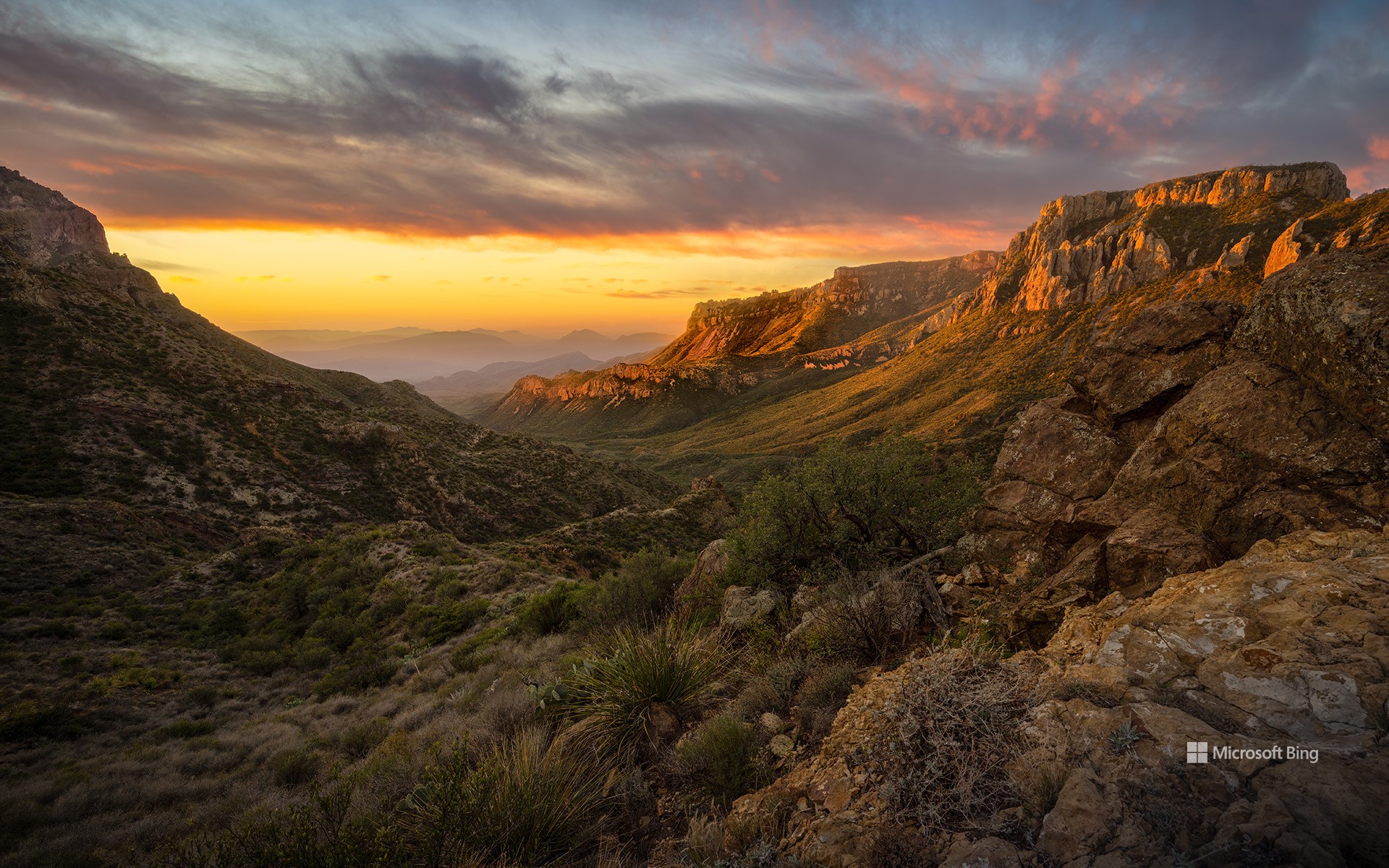
奇索斯山脉,大弯国家公园,德克萨斯州,美国 Chisos Mountains, Big Bend National Park, Texas (© Dean Fikar/Getty Images)
星空、岩石与孤寂 Stars, stone, and solitude
大弯国家公园迎来81周年
人们常说:“德州的一切都更大。”而大弯国家公园正是对这句话的最佳注解。这片占地801,163英亩的广袤区域,最初属于墨西哥领土,1848年并入美国。自20世纪30年代起,该地区的自然景观便受到保护,并于1944年6月12日正式被指定为国家公园。大弯国家公园是美国最偏远、游客最少的国家公园之一。它并非由单一地貌构成,而是三种景观的综合体:奇瓦瓦沙漠、奇索斯山脉和格兰德河。公园地处美墨边境,其历史也体现出文化交融的特征:原住民、西班牙探险者、牧场主、矿工和游客皆曾在此留下足迹。岩画、历史遗迹和古道见证了这片土地在成为国家公园之前就已拥有深厚历史。
公园内生物多样性极为丰富,记录有超过1,200种植物、超过450种鸟类,以及多种哺乳动物、爬行动物和两栖动物。你可能会看到一只走鹃迅速穿越沙尘,或是一只山猫悄然穿行于灌木之间。此外,大弯国家公园也被评为美国最佳暗夜公园之一。游客在此可观赏到银河、行星和满天繁星构成的璀璨星空。
Big Bend National Park in Texas turns 81
They say everything's bigger in Texas—and Big Bend National Park has been living up to the slogan since forever. Efforts to preserve this 801,163-acre area of West Texas began in the 1930s and culminated in its official designation as a park on June 12, 1944. Big Bend remains one of the most remote and least-visited national parks in the country. It's not just one landscape, it's three: the Chihuahuan Desert, the Chisos Mountains (pictured here), and the Rio Grande. Big Bend sits on the US–Mexico border, and its history reflects that blend. Indigenous peoples, Spanish explorers, ranchers, miners, and modern travelers have all left their footprints. Petroglyphs, ruins, and old trails show the land's story began long before it became a park.
The park is home to over 1,200 species of plants, more than 450 species of birds, and a wide variety of mammals, reptiles, and amphibians. You might spot a roadrunner zipping across the dirt, or a bobcat silently slipping through the underbrush. Additionally, it has been designated as one of the best dark-sky parks in America, offering views of the Milky Way, planets, and constellations.
Coll d'Ares,加泰罗尼亚比利牛斯山脉 Coll d'Ares, Catalan Pyrenees (© CRISTIAN IONUT ZAHARIA/Shutterstock)
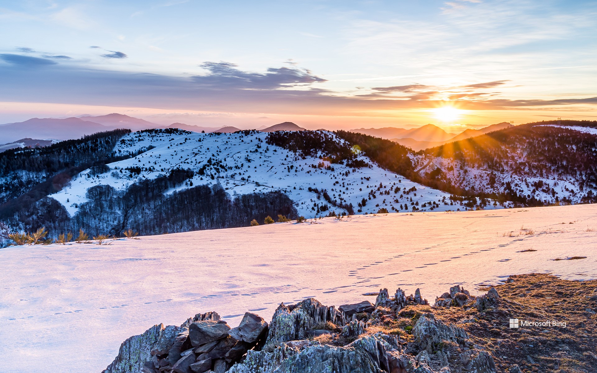
Coll d'Ares,加泰罗尼亚比利牛斯山脉 Coll d'Ares, Catalan Pyrenees (© CRISTIAN IONUT ZAHARIA/Shutterstock)
Coll d'Ares,加泰罗尼亚比利牛斯山脉
阿雷斯山口位于海拔1,512米,是穿越雄伟比利牛斯山脉、连接西班牙和法国的山间通道。山口位于加泰罗尼亚里波列斯地区的莫洛与法国奥克西塔尼亚的普拉茨德莫洛拉普雷斯特之间。冬季,这里白雪皑皑,景色令人叹为观止。
阿雷斯山口的历史可追溯至878年,不仅是一条地理通道,更是连接文化与历史的桥梁。其名称源自拉丁语‘ara’,意为祭坛,唤起了古代用神圣石碑标记边界的记忆。在九年战争期间,这里曾是重要军事行动的舞台。
如今,阿雷斯山口已成为探索自然的独特目的地。无论是徒步旅行、欣赏全景风光,还是探索丰富的历史,阿雷斯山口都能让游客流连忘返。在此感受比利牛斯山脉的清新空气,尽情沉浸于这片神奇的土地中吧!
艾纳, 塞古拉山脉, 阿尔瓦塞特, 西班牙 Ayna, Sierra del Segura, Albacete, Spain (© Juan Maria Coy Vergara/Getty Images)
艾纳, 塞古拉山脉, 阿尔瓦塞特, 西班牙 Ayna, Sierra del Segura, Albacete, Spain (© Juan Maria Coy Vergara/Getty Images)
西班牙的小瑞士 Spain's little Switzerland
艾纳,阿尔瓦塞特, 西班牙
说起西班牙,你脑海中首先浮现的可能不是雪,但从高耸入云的山峰到阳光温暖的海滩,西班牙拥有各种地貌。图片中的小村庄艾纳坐落于由蒙多河冲刷而成的陡峭山谷中,周围环绕着塞古拉山脉,人口不足1000人。冬季,这里白雪皑皑,因此人们常把这个小镇称为 “曼切根瑞士”。而这个名称中的“曼切根”则指的是艾纳所属的卡斯蒂利亚-拉曼恰自治区。艾纳距离西班牙首都马德里以南约150英里,是西班牙乡村生活的独特一瞥。
Aýna, Albacete, Spain
Welcome to the tiny Spanish village of Aýna, in a steep valley carved by the River Mundo in the Sierra del Segura range. This part of the Castile-La Mancha region is sometimes called Manchegan Switzerland, thanks to those snow-capped peaks during the winter months. The steep, rocky terrain here means the villagers, of whom there are less than 1,000, cultivate the land on terraces dug into the mountainside. To see Aýna from this perspective, you'll need to visit the Mirador del Diablo, or Devil's Viewpoint, one of several viewing areas dotted around this picturesque valley.
阿尔卑斯山脉锡尔夫雷塔山的乔里森湖,瑞士 Jöriseen lakes in the Silvretta Alps, Switzerland (© Florin Baumann/Getty Images)
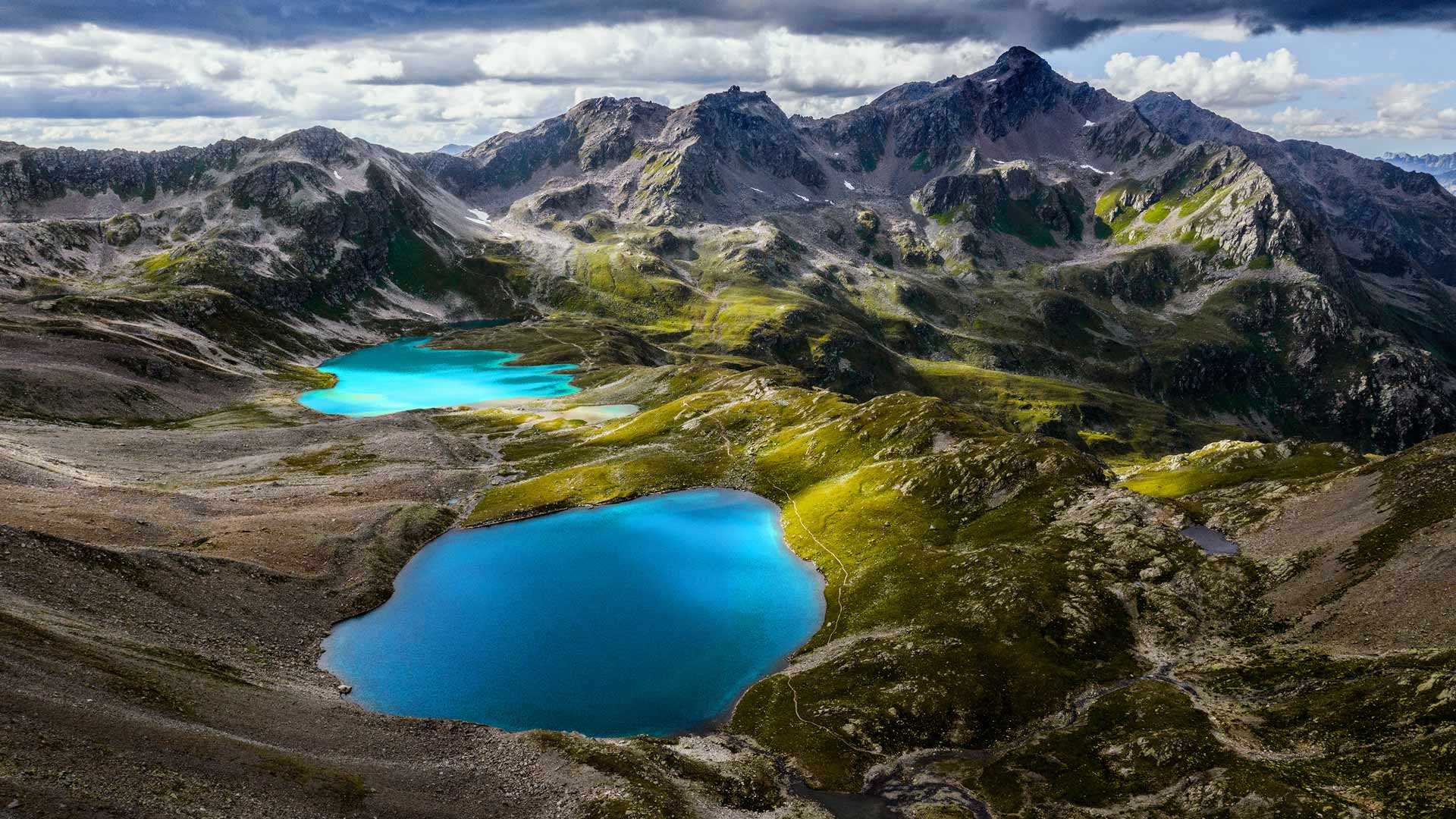
阿尔卑斯山脉锡尔夫雷塔山的乔里森湖,瑞士 Jöriseen lakes in the Silvretta Alps, Switzerland (© Florin Baumann/Getty Images)
蓝湖和险峰 Bright blue lakes and rugged mountains
阿尔卑斯山脉锡尔夫雷塔山的约里森湖,瑞士
今天我们要探索一处超凡脱俗的奇景:瑞士达沃斯附近的约里森湖群。天气晴朗时,湖面会呈现出不真实的蓝色,和周围灰暗、嶙峋的锡尔夫雷塔山形成鲜明的对比。阳光被水中的“岩粉”(湖床被冰川摩擦产生的细微的岩石颗粒)反射,形成了这种鲜艳的蓝色。锡尔夫雷塔山被冰川环绕,和碧蓝色的约里森湖一起被称为“蓝色锡尔夫雷塔”。如果你想亲眼目睹此景,要知道来到此地的路途并不容易。记得带上合适的徒步鞋、大量的饮用水和强健的双腿。
Jöriseen lakes in the Silvretta Alps, Switzerland
Today we're exploring a place of otherworldly beauty: the Jöriseen, a group of alpine lakes near Davos, Switzerland. On sunny days, the lakes glow an ethereal blue, contrasting with the dark, jagged Silvretta Alps that encircle them. The sunlight is reflected in the water by 'rock flour'—silt-sized rock particles generated from the grinding of bedrock by glaciers.
The Silvretta Alps sit across the Swiss-Austrian border and are themselves surrounded by glaciers in an area known as the 'Blue Silvretta.' If you want to enjoy these stunning views up close, you'll have to work for it. Bring your best hiking boots, plenty of water, and some strong legs.
菲希特尔山脉上的和平钟,萨克森州,德国 Peace bell on the summit of Fichtelberg, Saxony, Germany (© Jan Drahokoupil/Getty Images)
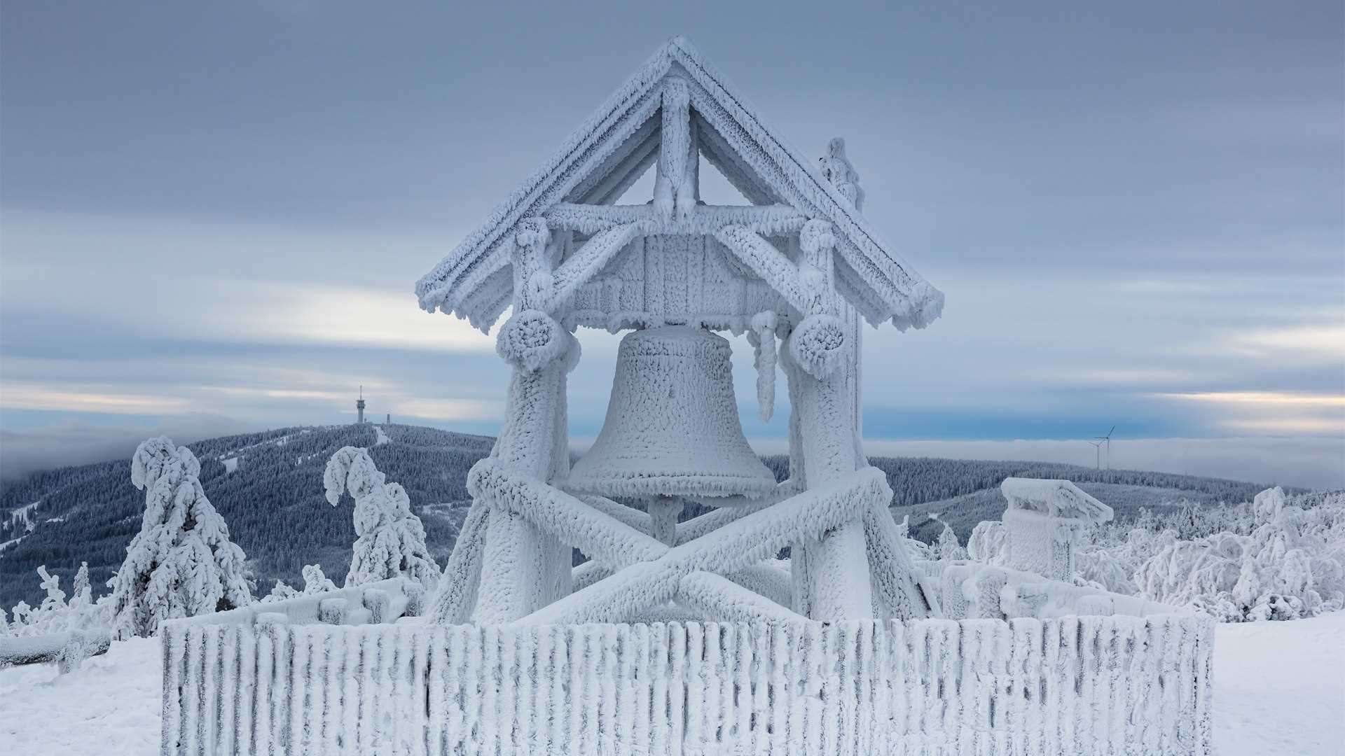
菲希特尔山脉上的和平钟,萨克森州,德国 Peace bell on the summit of Fichtelberg, Saxony, Germany (© Jan Drahokoupil/Getty Images)
和平之钟 A bell for peace
菲希特尔山脉,德国萨克森州
菲希特尔山位于厄尔士山脉的上维森塔尔镇附近。这座山高1214米,是东德最高的山峰,也是冬季运动爱好者的圣地。这里有各种冬季运动,双板滑雪、单板滑雪、越野滑雪、雪橇雪橇和马拉雪橇等等。如果你更喜欢夏天,也可以在这里来场夏日旅行,体验这里的自然风景。在菲希特尔山顶有一座和平钟,在这里欣赏到周围群山的壮丽景色。
Peace bell on Fichtelberg, Germany
The Fichtelberg is located on the Oberwiesenthal in the Ore Mountains. This mountain is 1214 m high, making it not only the highest mountain in East Germany but also a very prestigious place for winter sports enthusiasts. All kinds of sports are offered. From classic skiing and snowboarding to cross-country skiing, cross-country skiing tours, tobogganing, and horse-drawn sleigh rides. If you prefer summer, you can also enjoy this place in the warm season and completely immerse yourself in untouched nature. At the top of the mountain, you can visit the Fichtelberghaus. From there you have a breathtaking view of the surrounding mountains.
多洛米蒂山脉安特莫亚湖上的日晕,意大利 Sun halo over Lake Antermoia in the Dolomite Mountains of Italy (© Walter Donega/Getty Images)
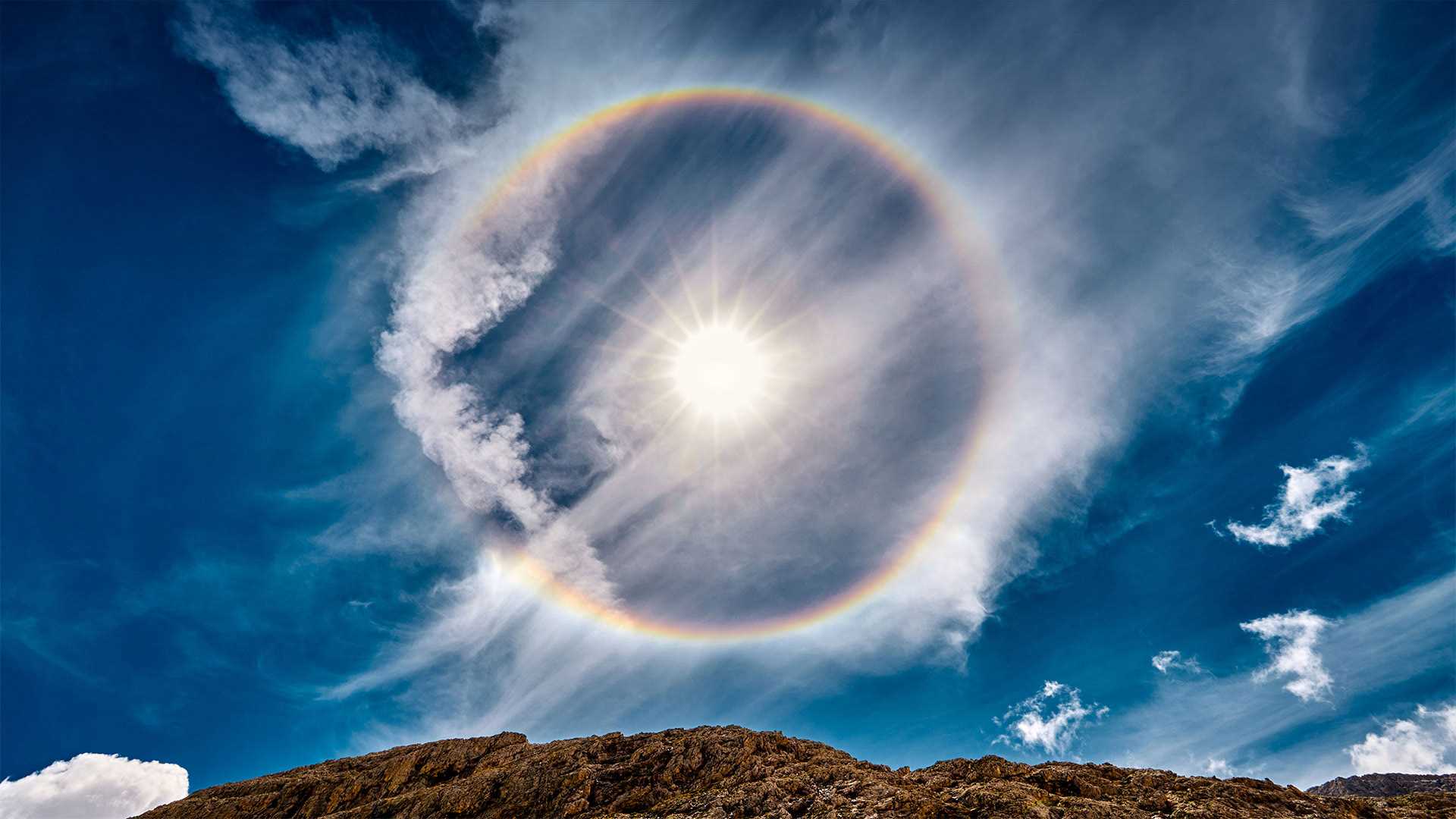
多洛米蒂山脉安特莫亚湖上的日晕,意大利 Sun halo over Lake Antermoia in the Dolomite Mountains of Italy (© Walter Donega/Getty Images)
环绕太阳的彩虹 Rainbow around the sun
意大利安特莫亚湖上空的太阳晕
从这里开始,日子只会变长!北半球今天标志着冬天的开始,但冬至也是一年中最短的一天。这里环绕太阳的彩虹,一个太阳光环,位于意大利北部多洛米特山脉的安特摩亚湖上方。当太阳或月亮的光线穿过悬浮在上层大气中的冰晶时,就会形成太阳晕。当太阳光照射到晶体上时,它们就充当了一个棱镜,将光分成光谱中的不同颜色,就像暴雨后彩虹出现的方式一样。
Sun halo over Lake Antermoia, Italy
The days only get longer from here! The Northern Hemisphere marks the beginning of winter today, but the winter solstice is also the shortest day of the year. The rainbow that encircles the sun here, a sun halo, is above Lake Antermoia, in the Dolomite Mountains of northern Italy. Sun halos form when sun or moon light shines through ice crystals suspended in the upper atmosphere. When the light of the sun hits the crystals they serve as a prism, separating the light into individual colors of the spectrum, the same way rainbows occur after a rain shower.
泰根塞山脉Roßstein山顶的景色,德国巴伐利亚州 View from the summit of Roßstein mountain, Bavaria, Germany (© Christian Bäck/eStock Photo)
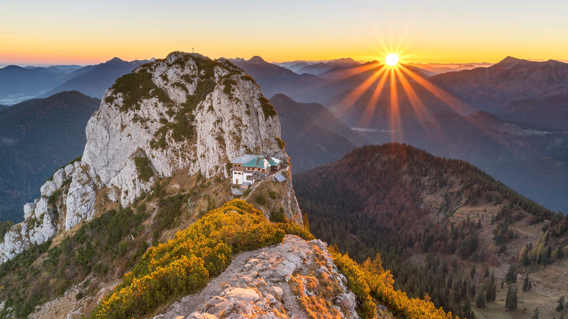
泰根塞山脉Roßstein山顶的景色,德国巴伐利亚州 View from the summit of Roßstein mountain, Bavaria, Germany (© Christian Bäck/eStock Photo)
国际山岳日 International Mountain Day
特根塞山脉
山脉是我们世界上最有趣的地质特征之一。山脉也成为无数代人类的游乐场和崇拜场所,这清楚地证明了地球表面下发生的巨大变化。几千年来,任何对如此多的人和文化如此重要的东西都值得纪念。因此,在12月11日,我们庆祝国际山地日!
我们的旅程将带我们前往位于特根塞山脉的上巴伐利亚州,这是一个属于巴伐利亚前阿尔卑斯山脉的山区。这张照片显示了从罗ß斯坦河(1698米)到布赫斯坦河(1701米)的景色。这两座山形成了一座双峰,泰格恩塞·吕特(Tegernsee Hütte)就坐落在它的马鞍上。该避难所于5月中旬至11月初开放,为徒步旅行者和登山者提供食宿。由于其暴露的位置,其位置通常被称为“鹰巢”。
Tegernsee Mountains
Mountains are some of the most interesting geological features that our world has to offer. Clear proof of the massive changes that happen beneath the surface of our planet, mountains have also served as playgrounds and places of worship for countless generations of humans. Anything that’s been such a mainstay for so many people and cultures through millennia is worth commemorating. So on December 11, we celebrate International Mountain Day!
Our excursion takes us to Upper Bavaria in the Tegernsee Mountains, a mountain region that belongs to the Bavarian Pre-Alps. The photo shows the view from the Roßstein (1,698 meters) to the Buchstein (1,701 meters). Both mountains form a double peak, in whose saddle the Tegernsee Hütte nestles. The refuge, which is open from mid-May to early November, offers board and lodging to hikers and climbers. Due to its exposed location, its location is often referred to as the "eagle's nest".
阿拉瓦利山脉的阿布山,印度拉贾斯坦邦 Mount Abu and the Aravalli Range in Rajasthan, India (© saiko3p/Shutterstock)
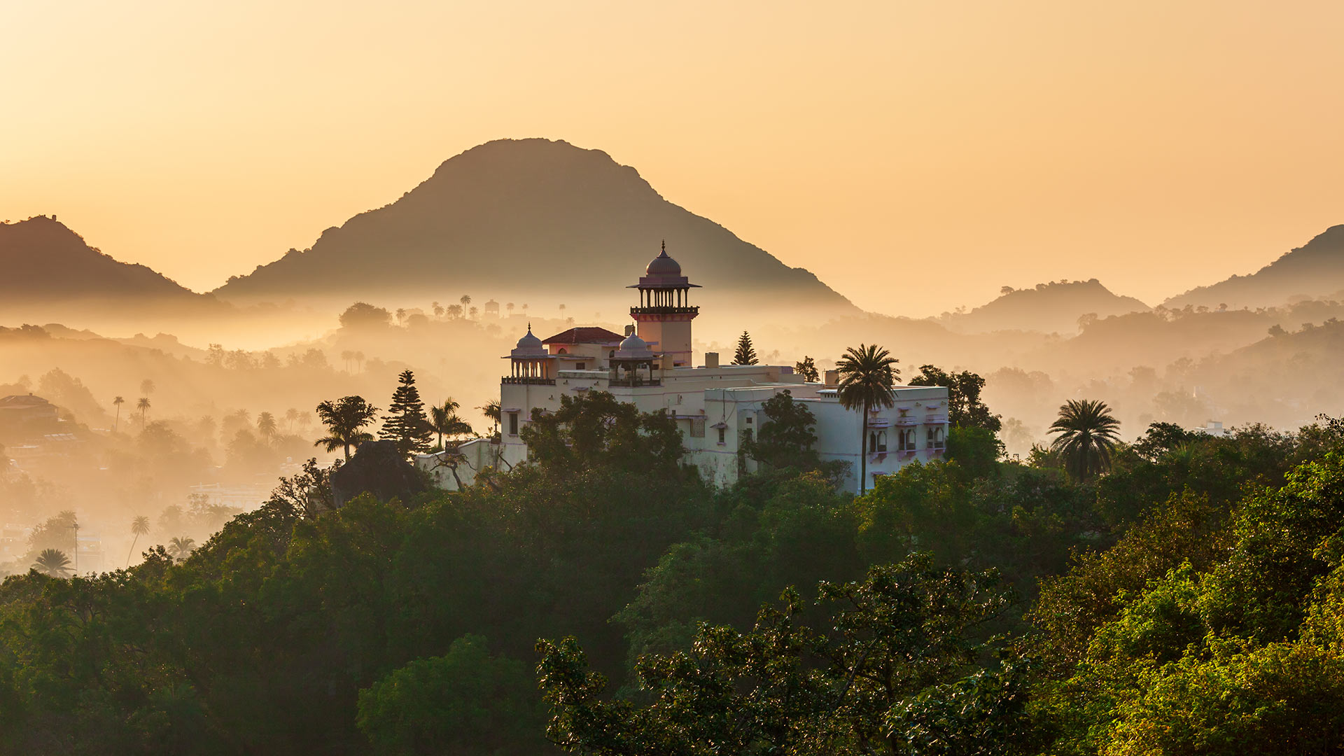
阿拉瓦利山脉的阿布山,印度拉贾斯坦邦 Mount Abu and the Aravalli Range in Rajasthan, India (© saiko3p/Shutterstock)
印度拉贾斯坦邦阿布山
阿布山(Mount Abu)是拉贾斯坦邦唯一的山地站,海拔1722米,被阿拉瓦利山脉(Aravalli Range)郁郁葱葱的绿色山丘环绕,为人们提供了急需的缓解拉贾斯坦斯坦酷热天气的方法。它被称为“沙漠中的绿洲”,因为它的高度是河流、湖泊、瀑布和常绿森林的家园。
阿布山由部落社区的乡村住宅和豪华住宅(包括英式平房和皇家度假屋)组成,五彩缤纷,在这个沙漠之州,阿布山似乎不亚于一个奇迹。除了风景优美之外,该地还有几座印度教和耆那教寺庙,包括Arbuda Devi Temple、Shri Raghunath Temple、Dilwara Temple等。您还可以参观附近的阿查尔加尔堡、纳基湖和德鲁迪亚瀑布。
Mount Abu, Rajasthan, India
Providing much-needed relief from the blazing heat of Rajasthan, Mount Abu, the state’s only hill station, stands at a height of 1,722 meters above sea level and is embraced by the lush green hills of the Aravalli Range. It is referred to as 'an oasis in the desert as its heights are home to rivers, lakes, waterfalls, and evergreen forests.
Studded with a colorful mix of rustic abodes of tribal communities and posh houses inclusive of British-style bungalows and royal holiday lodges, Mount Abu appears to be no less than a wonder in this desert state. Other than its scenic beauty, the place is home to several Hindu and Jain temples, including Arbuda Devi Temple, Shri Raghunath Temple, Dilwara Temple, and more. You can also visit the Achalgarh Fort, Nakki Lake, and Dhrudiya Waterfalls that are nearby.
奥尔德萨和佩尔迪多山国家公园里的瀑布,西班牙比利牛斯山脉 Waterfall on the Rio Arazas in Ordesa y Monte Perdido National Park, Pyrenees, Spain (© David Santiago Garcia/Cavan Images)
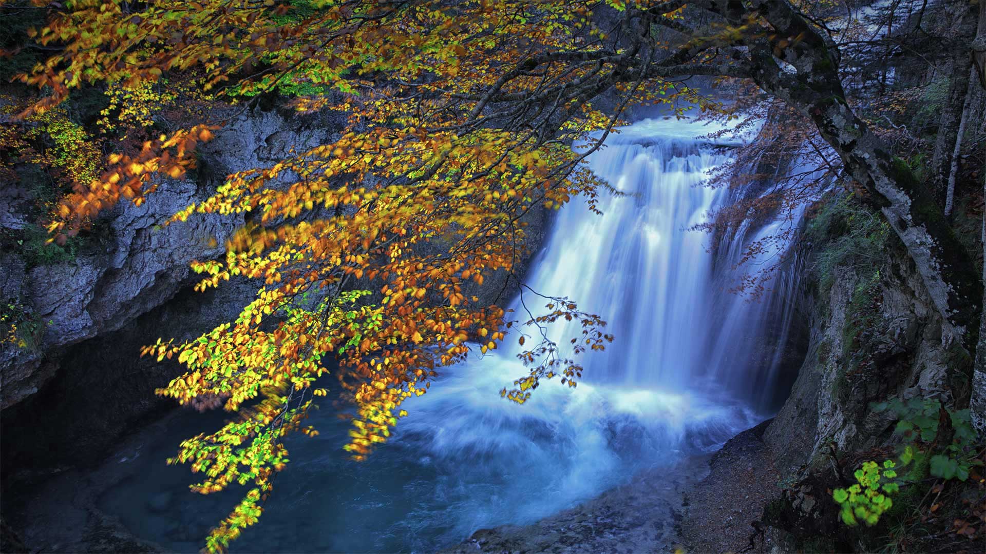
奥尔德萨和佩尔迪多山国家公园里的瀑布,西班牙比利牛斯山脉 Waterfall on the Rio Arazas in Ordesa y Monte Perdido National Park, Pyrenees, Spain (© David Santiago Garcia/Cavan Images)
通往伊比利亚的门户 Gateway to Iberia
西班牙比利牛斯山脉奥德萨和蒙特佩迪多国家公园的里奥·阿拉扎斯
比利牛斯山脉在任何季节都很引人注目,但在夏季温暖持续到秋季的年份尤其美丽,自最早的文明在那里扎根以来,比利牛斯半岛一直是伊比利亚半岛和欧洲其他地区之间的天然边界。位于山脉中心的Ordesa y Monte Perdido国家公园创建于1918年,并于1982年扩建。如今,它已成为联合国教科文组织的世界遗产。
该公园拥有陡峭的悬崖和深邃、翠绿的山谷,是摄影师的梦想,拥有由比利牛斯山脉剧烈的海拔变化形成的卓越地质地貌和多样生态。该地区是几个只能在这里找到的物种的家园,包括比利牛斯羚羊和比利牛斯山羚羊,或水鼹鼠。这种被认为是该地区最稀有和最重要的哺乳动物,布卡多山羊或比利牛斯山羊,尽管进行了保护工作,但于2000年1月灭绝。
Rio Arazas in Ordesa and Monte Perdido National Park, Pyrenees, Spain
Striking in any season, but particularly beautiful in years when the warmth of summer stretches into fall, the Pyrenees have served as a natural border between the Iberian Peninsula and the rest of Europe since the earliest civilizations took root there. Located in the center of the range, the Ordesa y Monte Perdido National Park was created in 1918 and expanded in 1982. Today it is a UNESCO World Heritage Site.
Boasting sheer cliffs and deep, verdant valleys, the park is a photographer's dream, with a landscape marked by remarkable geological landforms and diverse ecologies shaped by the drastic elevation changes of the Pyrenees. The region is home to several species that can only be found here, including the Pyrenean chamois and the Pyrenean desman, or water mole. The mammal considered the most rare and important in the region, the bucardo or Pyrenean ibex, went extinct in January 2000 despite preservation efforts.