标签 巴伐利亚 下的文章
天鹅堡和旧天鹅堡,巴伐利亚阿尔卑斯山,德国 Neuschwanstein and Hohenschwangau Castles, Bavarian Alps, Germany (© Harald Nachtmann/Getty Images)
天鹅堡和旧天鹅堡,巴伐利亚阿尔卑斯山,德国 Neuschwanstein and Hohenschwangau Castles, Bavarian Alps, Germany (© Harald Nachtmann/Getty Images)
童话故事中的场景 Straight out of a fairy tale
新天鹅堡和旧天鹅堡,巴伐利亚,德国
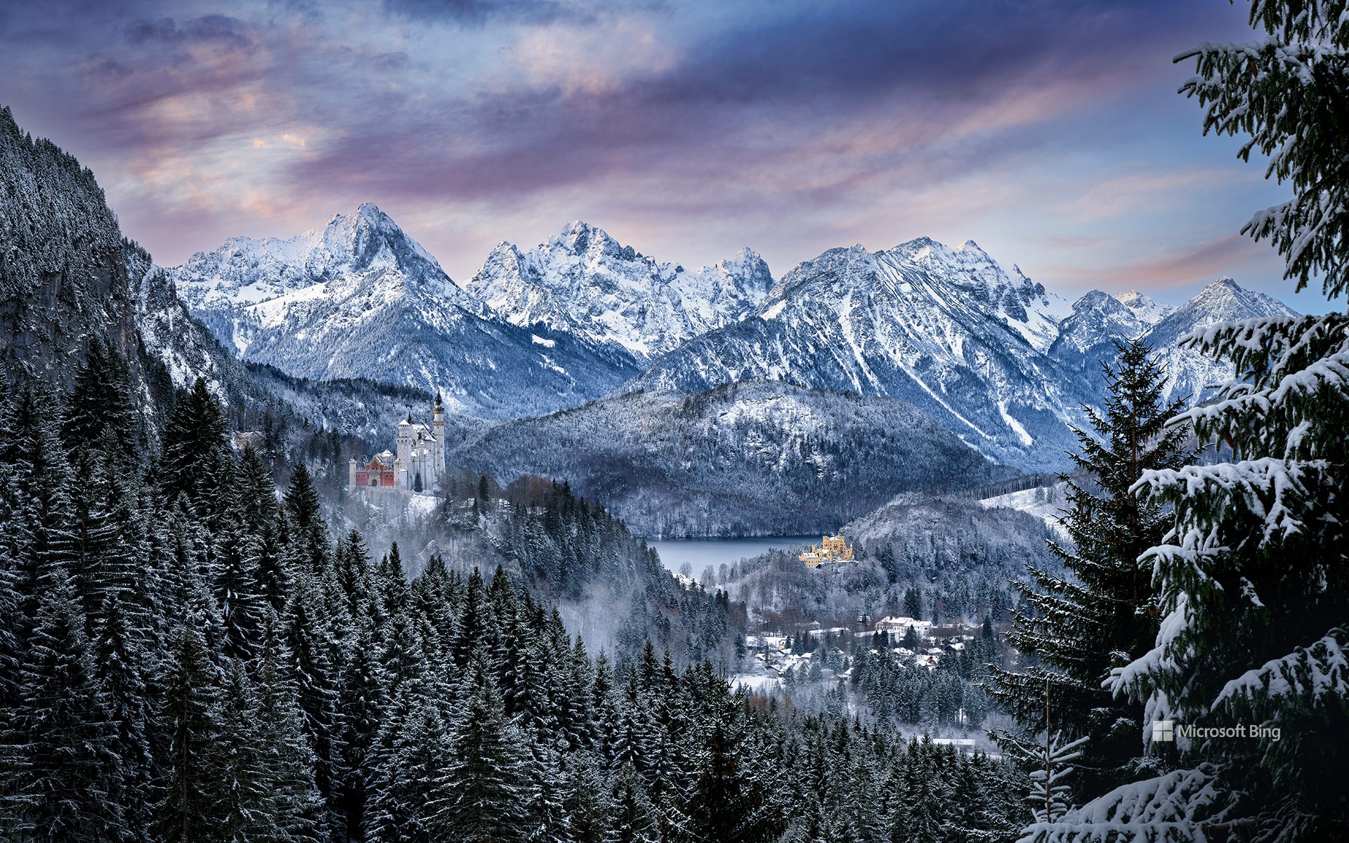
巴伐利亚阿尔卑斯山是德国南部一座雄伟的山脉,拥有两座城堡:新天鹅堡和旧天鹅堡。新天鹅堡是19世纪由巴伐利亚国王路德维希二世委托建造的罗曼式复兴宫殿,以童话般的建筑、塔楼和令人叹为观止的山景而闻名。越过山谷,远眺阿尔卑斯湖,是同样壮观的旧天鹅堡,由路德维希二世的父亲,巴伐利亚国王马克西米连二世建造。这两座城堡拥有奢华的内部装饰、丰富的艺术品和历史文物,每年都有数百万游客前往,一窥巴伐利亚的辉煌历史。
Neuschwanstein and Hohenschwangau castles, Bavaria, Germany
The Bavarian Alps, a mountain range in southern Germany, are home to these enchanting 19th-century castles, Neuschwanstein and Hohenschwangau. Neuschwanstein Castle, on the left of our homepage image, was commissioned by King Ludwig II of Bavaria. Building work began in 1869 on this Romanesque Revival palace with its fairy-tale-like architecture and breathtaking mountain backdrop. Across the valley, gazing out over Lake Alpsee, is the equally spectacular Hohenschwangau Castle, built by Ludwig II's father, King Maximilian II of Bavaria. These two castles boast rich interiors with intricate artwork and historical artifacts. Both castles attract millions of visitors every year, offering a glimpse into the opulent past of Bavaria.
多瑙河畔的帕绍市,巴伐利亚,德国 The city of Passau reflecting in the Danube river, Bavaria, Germany (© Scott Wilson/Alamy)
多瑙河畔的帕绍市,巴伐利亚,德国 The city of Passau reflecting in the Danube river, Bavaria, Germany (© Scott Wilson/Alamy)
巴洛克风盛宴 A Baroque treasure
帕绍,德国
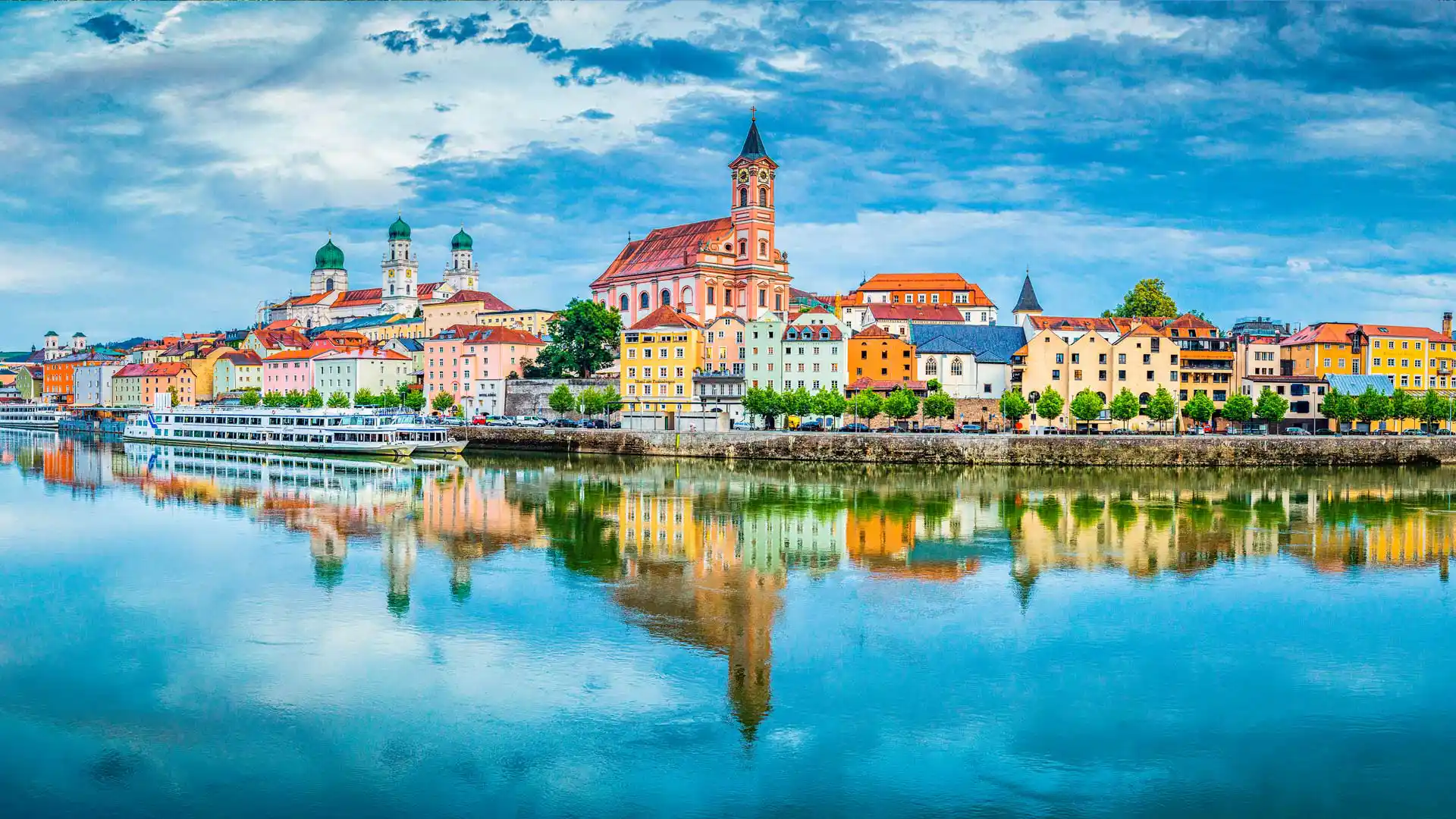
帕绍位于德国的下巴伐利亚州,因为多瑙河、因河和伊尔茨河在此交汇,帕绍又被称作“三河之城”。帕绍以其哥特风格和巴洛克风格的建筑闻名。多瑙河和伊尔茨河之间的山上坐落着上韦斯特城堡和下韦斯特城堡,俯瞰着这座城市。
今天的帕绍是一座古老和现代相互交织的城市。从老城漫步到满是高端店铺的新中心,这一路上你会看到城市现代化的同时还保留着很多古老的传统。老城还有一个“艺术家区”——Höllgasse,这里的老房子里满是工作室、工坊和画廊。帕绍还有各种各样的美食,本地的酒吧和酒馆可以提供最棒的巴伐利亚和奥地利食物。
泰根塞山脉Roßstein山顶的景色,德国巴伐利亚州 View from the summit of Roßstein mountain, Bavaria, Germany (© Christian Bäck/eStock Photo)
泰根塞山脉Roßstein山顶的景色,德国巴伐利亚州 View from the summit of Roßstein mountain, Bavaria, Germany (© Christian Bäck/eStock Photo)
国际山岳日 International Mountain Day
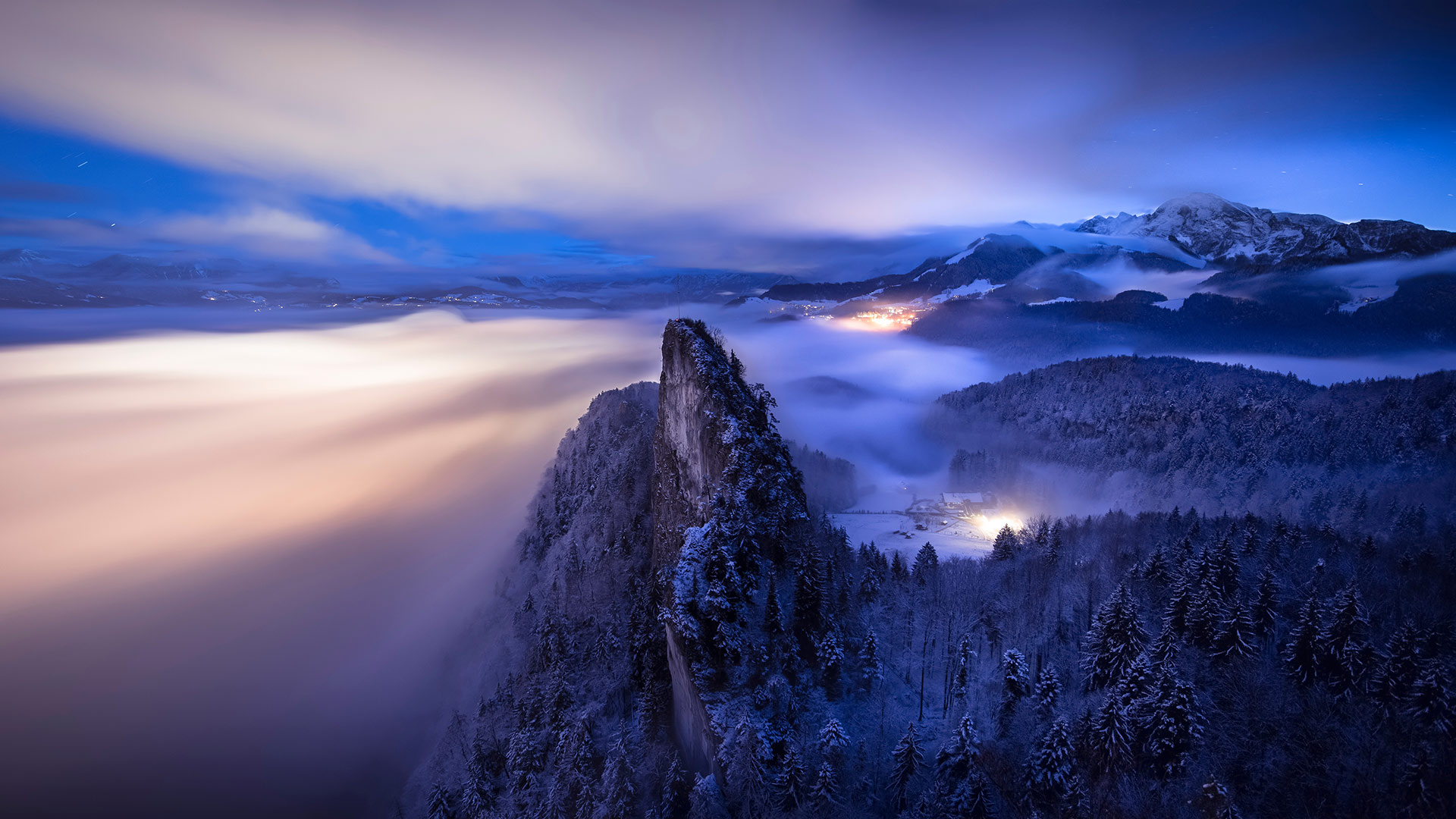
特根塞山脉
山脉是我们世界上最有趣的地质特征之一。山脉也成为无数代人类的游乐场和崇拜场所,这清楚地证明了地球表面下发生的巨大变化。几千年来,任何对如此多的人和文化如此重要的东西都值得纪念。因此,在12月11日,我们庆祝国际山地日!
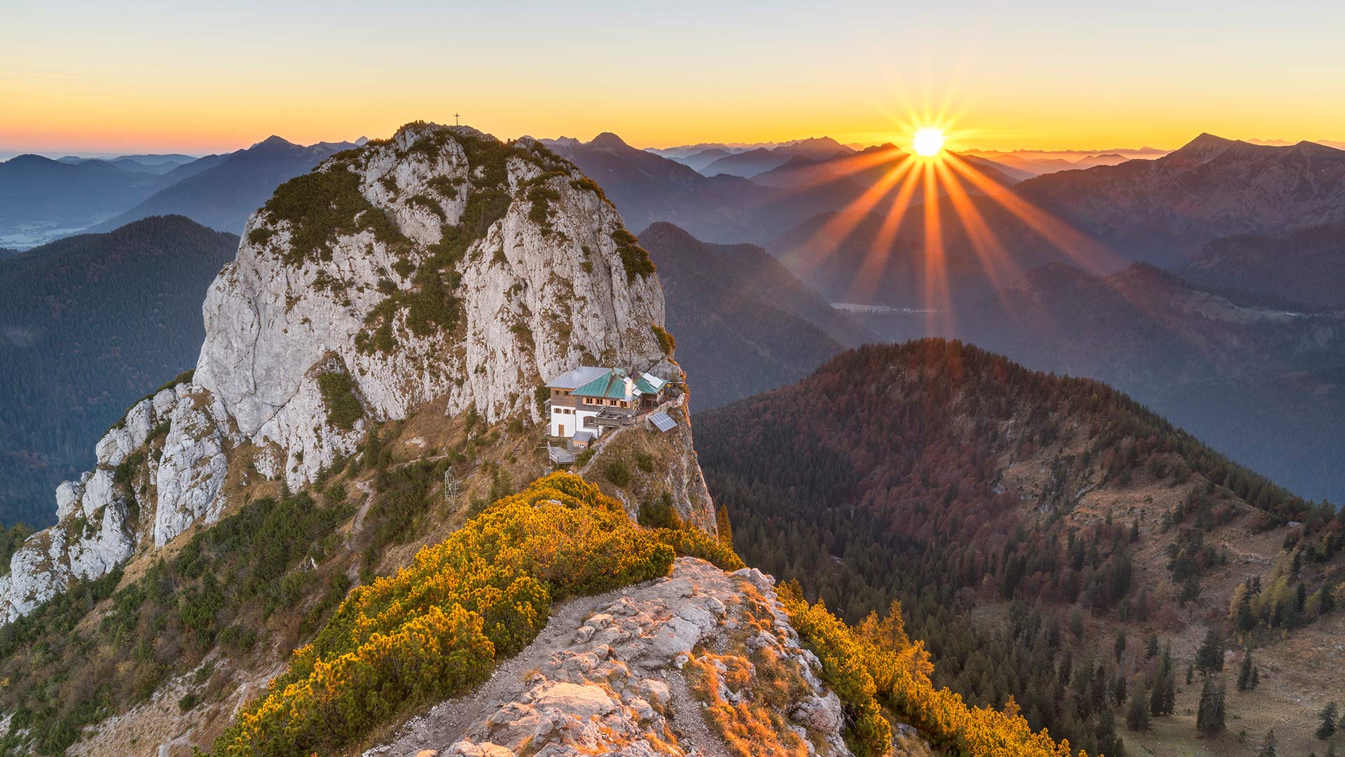
我们的旅程将带我们前往位于特根塞山脉的上巴伐利亚州,这是一个属于巴伐利亚前阿尔卑斯山脉的山区。这张照片显示了从罗ß斯坦河(1698米)到布赫斯坦河(1701米)的景色。这两座山形成了一座双峰,泰格恩塞·吕特(Tegernsee Hütte)就坐落在它的马鞍上。该避难所于5月中旬至11月初开放,为徒步旅行者和登山者提供食宿。由于其暴露的位置,其位置通常被称为“鹰巢”。
Tegernsee Mountains
Mountains are some of the most interesting geological features that our world has to offer. Clear proof of the massive changes that happen beneath the surface of our planet, mountains have also served as playgrounds and places of worship for countless generations of humans. Anything that’s been such a mainstay for so many people and cultures through millennia is worth commemorating. So on December 11, we celebrate International Mountain Day!
Our excursion takes us to Upper Bavaria in the Tegernsee Mountains, a mountain region that belongs to the Bavarian Pre-Alps. The photo shows the view from the Roßstein (1,698 meters) to the Buchstein (1,701 meters). Both mountains form a double peak, in whose saddle the Tegernsee Hütte nestles. The refuge, which is open from mid-May to early November, offers board and lodging to hikers and climbers. Due to its exposed location, its location is often referred to as the "eagle's nest".
坎彭万德山,基姆高地区阿绍,德国巴伐利亚州 View from Kampenwand mountain, Aschau im Chiemgau, Bavaria, Germany (© Toni Anzenberger/plainpicture)
坎彭万德山,基姆高地区阿绍,德国巴伐利亚州 View from Kampenwand mountain, Aschau im Chiemgau, Bavaria, Germany (© Toni Anzenberger/plainpicture)
令人惊叹的山顶美景 Stunning mountain top view
巴伐利亚州坎本万德山
冬天已经来到了坎彭德的顶峰。在春季和夏季,许多徒步旅行者、山地自行车手、登山者、悬挂滑翔机和滑翔伞爱好者在这里嬉戏,在寒冷的季节,一点平静逐渐回归。现在,该地区正成为雪鞋徒步旅行者和滑雪旅游者的吸引力。
根据观看方向的不同,您可以欣赏坎彭德的壮丽全景。阿尔卑斯山麓和基姆山脉向北延伸,在晴朗的日子,你甚至可以看到西北部的慕尼黑电视塔。在南部-如这张照片中所示-可以看到巴伐利亚和奥地利山脉的独特景色。
Kampenwand mountain, Bavaria
Winter has already arrived at the summit of the Kampenwand. Where numerous hikers, mountain bikers, and climbers as well as hang-gliders, and paragliders cavort in spring and summer, a little calm gradually returns in the cold season. Now the region is becoming an attractive attraction for snowshoe hikers and touring skiers.
Depending on the viewing direction, you can enjoy a magnificent panorama from the Kampenwand. The foothills of the Alps with the Chiemsee stretch northwards, and on a clear day, you can even spot Munich's television tower in the northwest. In the south - as in this photo - there is a unique view of the Bavarian and Austrian mountains.
基姆湖上的淑女岛,德国巴伐利亚州 Aerial view of Fraueninsel island in Chiemsee, Bavaria, Germany (© Malorny/Getty Images)

基姆湖上的淑女岛,德国巴伐利亚州 Aerial view of Fraueninsel island in Chiemsee, Bavaria, Germany (© Malorny/Getty Images)
“巴伐利亚海”中的岛屿 Island in the "Bavarian Sea"
Fraueninsel, Chiemsee, Bayern
Just 15.5 hectares in size, the Fraueninsel is still the second-largest island in the Chiemsee after the Herreninsel - admittedly, there are only three inland islands in total, and the tiny Krautinsel as the third in the group is also uninhabited. The car-free Fraueninsel, whose appearance is mainly characterized by the Benedictine monastery of Frauenchiemsee (also known as Frauenwörth), founded in 782, can be reached all year round with the passenger ships of the Chiemsee shipping company.
The only settlement on the Fraueninsel is called Frauenchiemsee. It consists of about 50 houses in which around 250 people live. The name of the place and the island are often used synonymously. Chiemsee, which covers almost 80 square kilometers, is Bavaria's largest lake and Germany's third-largest after Lake Constance and Müritz. In the absence of its own seashore, an affectionate nickname for Lake Chiemsee has emerged among the Bavarian population over time: it is very often referred to as the "Bavarian Sea".
Fraueninsel、切姆西、拜仁
面积只有15.5公顷的弗劳尼塞尔岛仍然是基姆塞岛上仅次于赫雷宁塞尔岛的第二大岛屿——不可否认,总共只有三个内陆岛屿,而作为该群岛第三大岛屿的小克劳蒂塞尔岛也无人居住。无车Fraueninsel的外观主要以建于782年的Frauenchiemsee(也称为Frauenwörth)本笃会修道院为特征,可以通过Chiemsee航运公司的客船全年到达。
关于Fraueninsel的唯一解决方案称为Frauenchiemsee。它由大约50座房屋组成,其中约有250人居住。这个地方和这个岛的名字通常是同义词。基姆塞湖占地近80平方公里,是巴伐利亚州最大的湖泊,也是德国仅次于康斯坦斯湖和缪里兹湖的第三大湖。由于没有自己的海岸,随着时间的推移,基姆塞湖在巴伐利亚人中出现了一个亲切的昵称:它通常被称为“巴伐利亚海”。
贝希特斯加登阿尔卑斯山脉全景,德国巴伐利亚州 Panoramic view of the Berchtesgaden Alps, Bavaria, Germany (© Spotcatch/Westend61/Offset)
贝希特斯加登阿尔卑斯山脉全景,德国巴伐利亚州 Panoramic view of the Berchtesgaden Alps, Bavaria, Germany (© Spotcatch/Westend61/Offset)
冬日阿尔卑斯山脉的高峰 Peak winter in the Alps
Berchtesgaden Alps, Germany
Rising out of the Bavarian mists near Germany’s border with Austrian are the Berchtesgaden Alps, which surround the market town of the same name. This pristine mountain landscape is popular with mountaineers and hikers, who have plenty of peaks to choose from. Berchtesgaden National Park, established in 1978, accommodates nine mountain ranges over 81 square miles, including the dominant Watzmann, one of Germany’s tallest mountains which reach 8,901ft (2,713m) at its highest point.
Berchtesgaden is the only Alpine national park in Germany and protects a varied landscape including deep forests, rugged cliffs, and glaciers as well as green valleys and pastures – complete with diverse plants and wildlife. Also hidden somewhere beneath that thick cloud lies the emerald-green Königssee, one of Germany’s highest and most photogenic lakes, nestled within steep mountain walls.
德国贝赫特斯加登阿尔卑斯山
从德国和奥地利边境附近的巴伐利亚薄雾中升起的是贝赫特斯加登阿尔卑斯山,它环绕着同名的集镇。这种原始的山景深受登山者和徒步旅行者的欢迎,他们有很多山峰可供选择。贝赫特斯加登国家公园建于1978年,共有九座山脉,面积超过81平方英里,其中包括占主导地位的瓦茨曼山脉,这是德国最高的山脉之一,最高点达8901英尺(2713米)。
Berchtesgaden是德国唯一的阿尔卑斯山国家公园,保护着各种各样的景观,包括深林、崎岖的悬崖、冰川、绿色的山谷和牧场,以及各种各样的植物和野生动物。在这片厚厚的云层下,还隐藏着翡翠绿色的克尼希湖,它是德国最高、最上镜的湖泊之一,坐落在陡峭的山墙内。
博格豪森镇和萨尔察赫河,德国巴伐利亚州 Burghausen town and Salzach river, Bavaria, Germany (© Harald Nachtmann/Moment/Getty Images)
博格豪森镇和萨尔察赫河,德国巴伐利亚州 Burghausen town and Salzach river, Bavaria, Germany (© Harald Nachtmann/Moment/Getty Images)
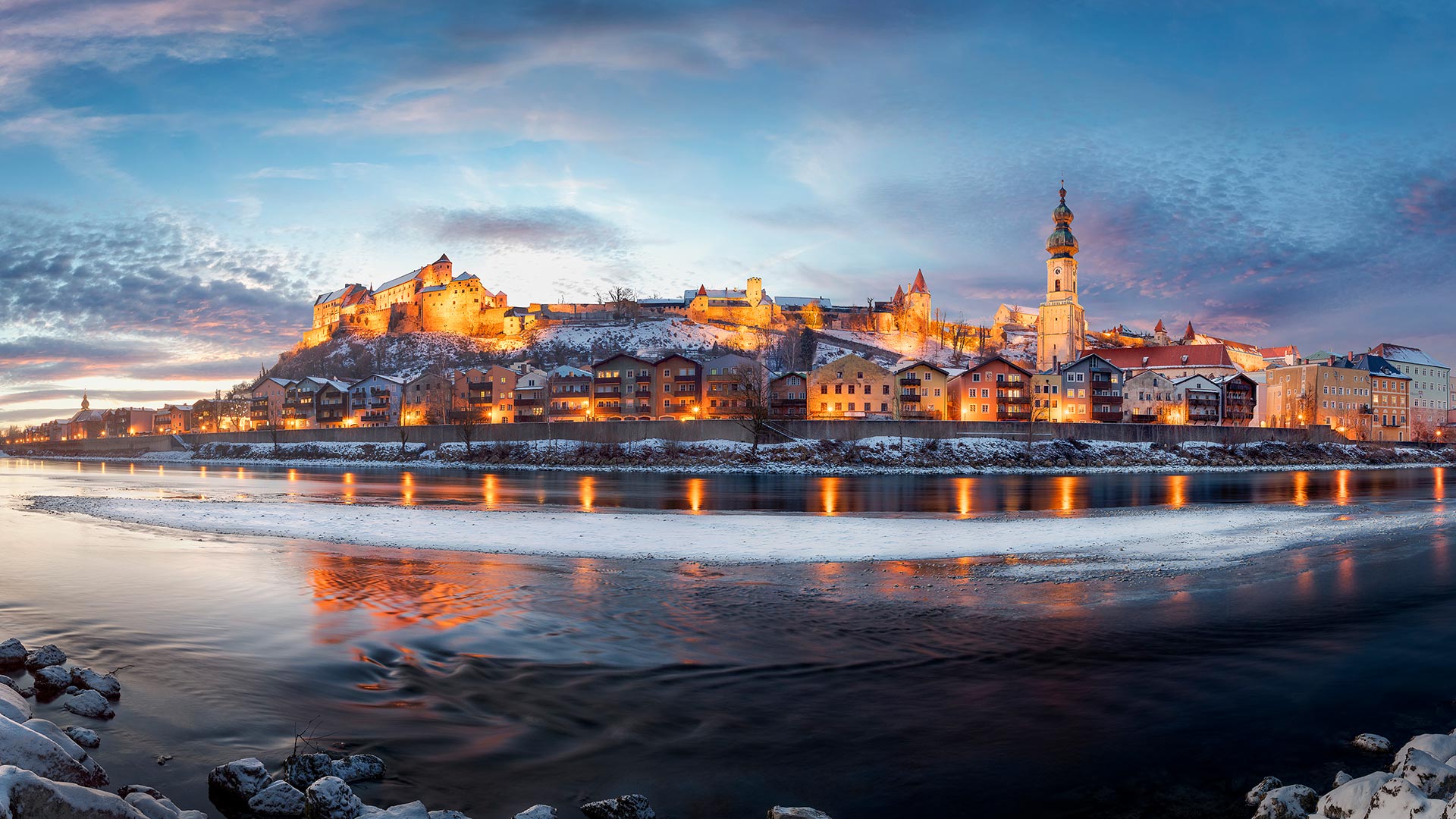
Burghausen town and Salzach river, Bavaria, Germany
The town of Borghausen is located on the banks of the Salchach, a large river in the Alps, which at 225 km. The name "castle" is rarely as specific as it is in upper Bavarian town, cause Borghausen boasts the world's longest castle complex at 1,051 meters.
The impressive defensive structure sits on a ridge above the old town, with a total of six courtyards. The oldest part dates back to the Middle Ages, with the first documentary mentioning around 1025. The main castle represents the oldest part of it, which can be seen clearly on the left side in the picture.
德国巴伐利亚州Burghausen镇和Salzach河
Borghausen镇位于阿尔卑斯山脉的一条大河Salchach河岸上,全长225公里。“城堡”这个名字很少像在上巴伐利亚镇那样具体,因为博格豪森拥有世界上最长的城堡建筑群,高1051米。
令人印象深刻的防御结构坐落在老城上方的山脊上,共有六个庭院。最古老的部分可以追溯到中世纪,第一部纪录片提到1025年左右。主城堡代表了它最古老的部分,在图片的左侧可以清楚地看到。
冬日里的科赫尔湖,德国巴伐利亚州 Kochelsee and Heimgarten Mountain in Bavaria, Germany (© Reinhard Schmid/eStock Photo)
冬日里的科赫尔湖,德国巴伐利亚州 Kochelsee and Heimgarten Mountain in Bavaria, Germany (© Reinhard Schmid/eStock Photo)
Kochelsee in Bavaria
To English speakers, this is Lake Kochel. To German speakers, it's Kochelsee. Whatever you call it, this popular recreation spot in Bavaria looks great all decked out in winter white. Imagine how quiet it must be when the lake is blanketed by snow. Now stretch your imagination further to the warm summer months when the shores of Kochelsee are busy with tourists out to get a dose of nature. The lake is just an hour's journey by car or train, south from the Munich. Visit during summer and you're likely to see windsurfers gliding across the surface of the lake.
巴伐利亚州的科切西
对说英语的人来说,这是科切尔湖。对说德语的人来说,这是科切西。不管你怎么称呼它,这个巴伐利亚州广受欢迎的娱乐场所穿上冬装,看起来很棒。想象一下,当湖面被雪覆盖时,一定是多么安静。现在,让你的想象力进一步延伸到温暖的夏季,科切西海岸正忙于吸引游客到这里来体验大自然。从慕尼黑以南,乘汽车或火车到这个湖只有一个小时的路程。夏季游览,你可能会看到风帆冲浪者滑过湖面。
阿尔高阿尔卑斯山脉的Schrecksee湖,德国巴伐利亚 Lake Schrecksee in the Allgäu Alps, Bavaria, Germany (© Andreas Hagspiel/EyeEm/Getty Images)
阿尔高阿尔卑斯山脉的Schrecksee湖,德国巴伐利亚 Lake Schrecksee in the Allgäu Alps, Bavaria, Germany (© Andreas Hagspiel/EyeEm/Getty Images)
The picturesque lake in the Allgäu high Alps
The Schrecksee in the Allgäu High Alps has the reputation among mountain hikers as being the most beautiful mountain lake in the Alps. We don't want to commit ourselves, but given this magnificent record, it's undeniable that he's definitely making it into the top 10. The picturesque mountain lake lies at 1,813 metres in a cauldron-like high valley, surrounded by six Allgäu mountain peaks called Knappenkopf, Kirchendach, Kälbelespitze, Kastenkopf, Lahnerkopf and Älpelekopf.
The ascent to the Schrecksee takes about three hours from Bad Hindelang in the Oberallgäu. A good basic level of fitness is a prerequisite for almost 1,000 meters of altitude. There is a good chance of encountering marmots and eagles along the way. And those who are not sensitive to the cold can take a refreshing swim in the idyllic lake after the strenuous ascent. This is probably why the Schrecksee got its name because its water is still shockingly cold even in midsummer.
阿尔高阿尔卑斯山风景如画的山湖
阿尔高阿尔卑斯山的Schrecksee湖被登山者誉为阿尔卑斯山上最美丽的山湖。我们不想作出承诺,但鉴于这一辉煌的记录,不可否认的是,他肯定会进入前10名。风景如画的山湖位于1813米处,坐落在一个像釜一样的高山谷中,周围环绕着六个山谷Knappenkopf, Kirchendach, Kälbelespitze, Kastenkopf, Lahnerkopf和Älpelekopf。
从奥伯拉格的巴德后德兰到施雷克西大约需要三个小时,良好的基本身体素质是海拔近1000米的先决条件。沿途很有可能遇到土拨鼠和老鹰。而那些对寒冷不敏感的人,可以在艰苦的攀登之后,在田园诗般的湖中畅游一番。这可能就是为什么Schrecksee的名字,因为它的水仍然令人震惊的冷,即使在仲夏。
新天鹅堡附近Pöllat峡谷的瀑布,德国巴伐利亚 Waterfall at Pöllat Gorge near Neuschwanstein Castle, Bavaria, Germany (© Gary Whitton/Alamy)
新天鹅堡附近Pöllat峡谷的瀑布,德国巴伐利亚 Waterfall at Pöllat Gorge near Neuschwanstein Castle, Bavaria, Germany (© Gary Whitton/Alamy)
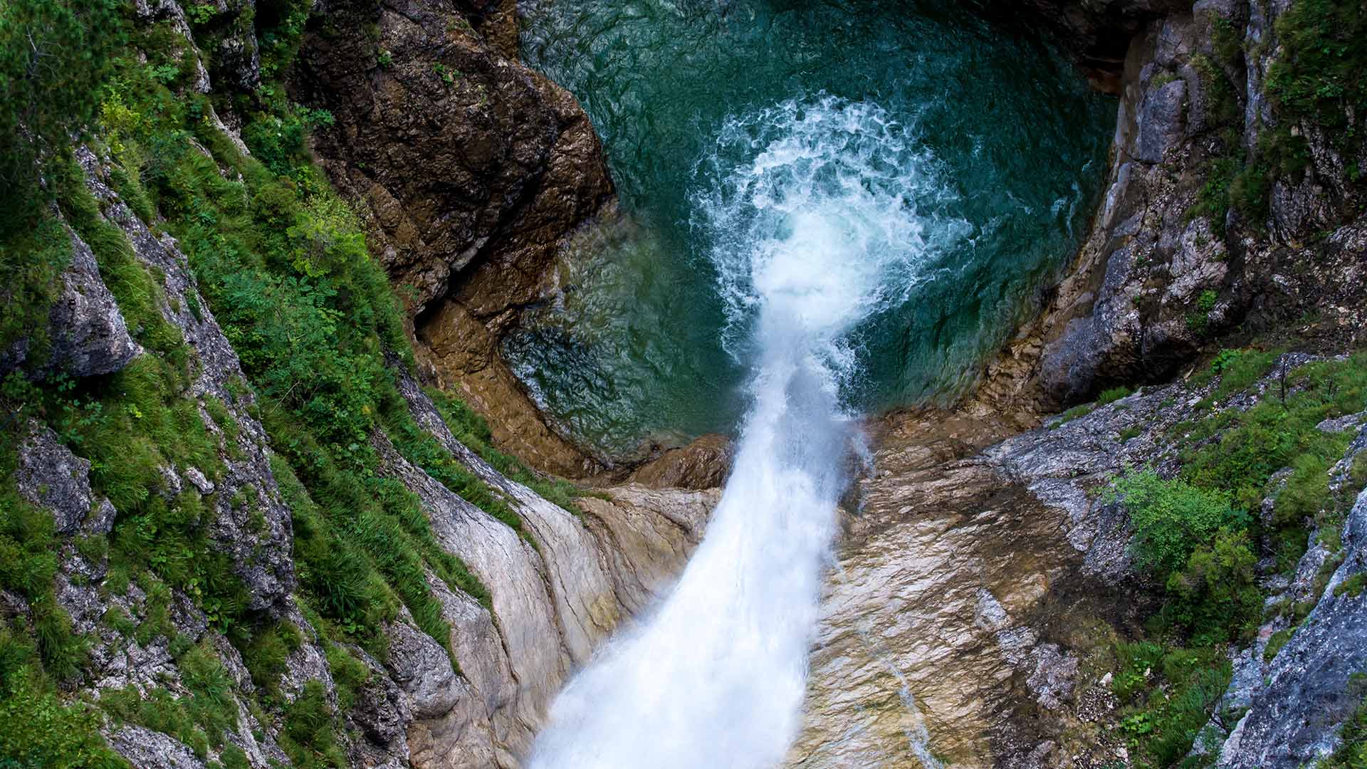
Waterfall of the "thundering brook"
The view down is only for those with a head for heights. At this point, the Pöllat plunges about 30 meters into the depths after it had previously made its way through the Königswinkel in the Allgäu. The most scenic part of the approximately ten kilometer long torrent leads through the Pöllat Gorge near Hohenschwangau. It is easily accessible via an iron footbridge and a hike offers spectacular viewpoints, for example on the Marienbrücke, which spans the gorge at a height of 90 meters.
The Pöllat overcomes an altitude difference of around 645 meters on its way down into the valley. It is no coincidence that the name is derived from the Celtic "Bellat", which means something like "thundering brook". If you are in the mood for culture after an excursion into nature, you will find a special attraction not far from the Pöllatfall. Neuschwanstein Castle, owned by the Bavarian fairy tale king Ludwig II, is one of the most beautiful castles in Germany.
“雷溪”瀑布
下面的景色只适合那些有高度头脑的人。在这一点上,Pö拉特在先前穿过K型潜艇后,潜入约30米深处ö所有的黑鬼ä美国。这条长约10公里的洪流最为壮观的部分穿过Pö霍亨施旺高附近的拉特峡谷。通过铁人行天桥很容易到达,徒步旅行可以看到壮观的景色,例如在Marienbr河上ü它横跨峡谷,高90米。
Pöllat在进入山谷的途中克服了大约645米的高度差。这个名字来自凯尔特人的“贝拉特”,意思是“雷鸣溪”,这绝非巧合。如果你在游览完自然后有了文化的心情,你会发现离P不远有一个特别的景点ö我摔倒了。巴伐利亚童话国王路德维希二世拥有的新天鹅堡是德国最美丽的城堡之一。