标签 阿拉斯加 下的文章
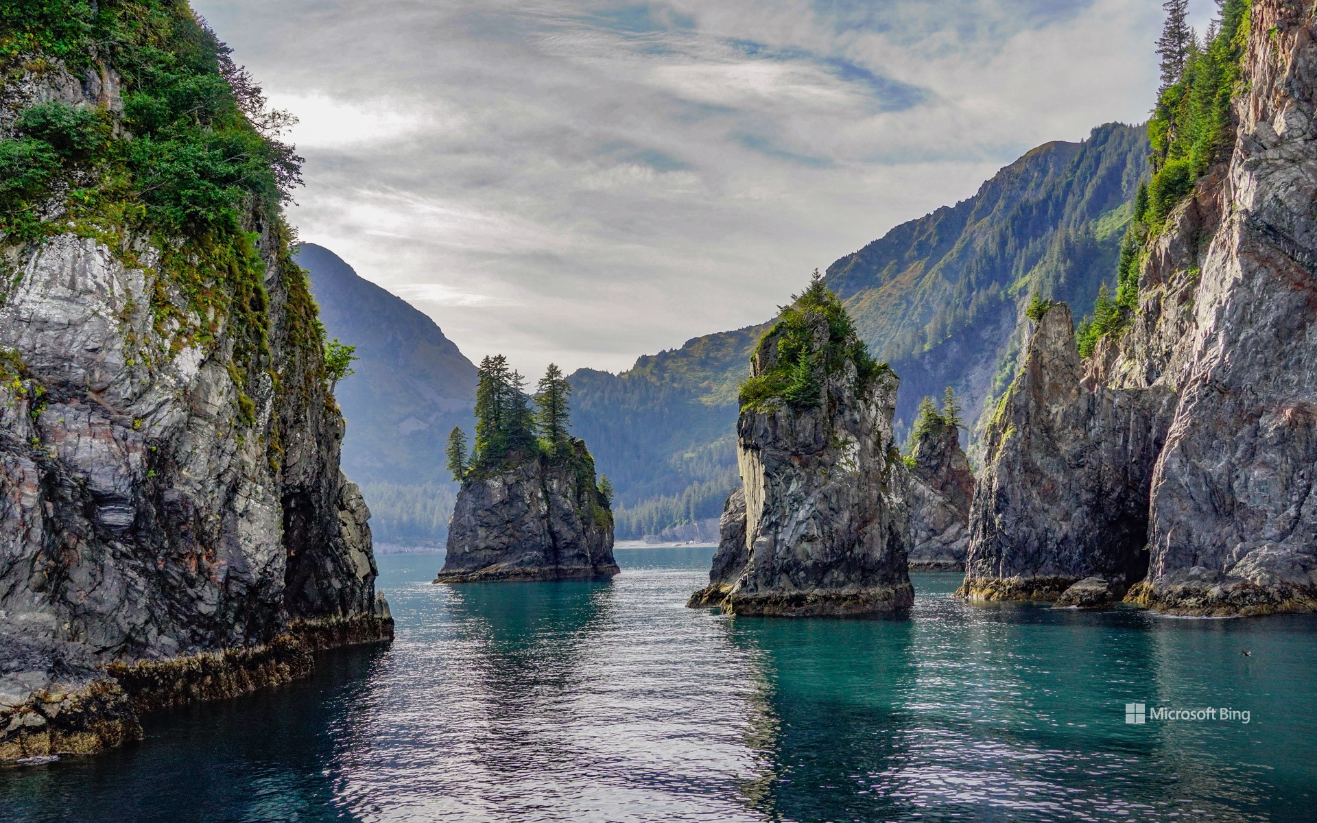
阿拉斯加基奈峡湾国家公园尖顶湾, 阿拉斯加州苏厄德, 美国 Spire Cove in Kenai Fjords National Park, Seward, Alaska (© Wander Photography/Getty Images)
阿拉斯加基奈峡湾国家公园尖顶湾, 阿拉斯加州苏厄德, 美国 Spire Cove in Kenai Fjords National Park, Seward, Alaska (© Wander Photography/Getty Images)
崎岖山峰与野性水域 Rugged peaks and wild waters
阿拉斯加基奈峡湾国家公园尖顶湾, 阿拉斯加州苏厄德
随着国家公园周的持续进行,让我们把目光转向阿拉斯加基奈半岛上的瑰宝——基奈峡湾国家公园。该公园面积超过1,000 平方英里,拥有高耸的峡湾、蜿蜒的河谷和高山地貌。其中超过一半的区域被冰雪覆盖,冰川占据了其面积的 51%。在 20 世纪,公园内的冰川不断消退,为植物和动物的生长腾出了新的土地。从古老的西加云杉到娇嫩的柳兰幼苗,再到覆盖森林地面的茂密苔藓,尽管地势崎岖,基奈峡湾的植物依然繁茂生长。该公园也是多种陆地和海洋哺乳动物的栖息地,包括森林狼、豪猪、加拿大猞猁,以及虎鲸和长须鲸等鲸目动物。这里还栖息着多种鸟类,如白头海雕和皮尔氏游隼。
基奈峡湾国家公园不仅有令人惊叹的自然景观和繁茂的荒野,还蕴藏着丰富的人类历史。几千年来,阿拉斯加原住民在此生活,留下了他们生活的痕迹。在国家公园的范围内,过去依然留下印记,从沿海分布的苏格皮亚克人(阿拉斯加原住民一族)营地,到努卡湾中废弃的旧矿营遗迹。这些历史的足迹和公园的自然奇观一样珍贵,为我们提供了与曾塑造这片土地的人们之间的重要连接。有如此丰富的内容可供探索,难怪基奈峡湾是该州最受欢迎的公园之一。
Spire Cove in Kenai Fjords National Park, Seward, Alaska
As National Park Week rolls on, let's turn our attention to Kenai Fjords National Park, a gem on Alaska's Kenai Peninsula. Stretching over 1,000 square miles, this landscape features fjords, river valleys, and alpine landscapes. More than half of the terrain is blanketed in ice. Throughout the 20th century, the park's glaciers have receded, uncovering new land for plant and animal life to take root. From ancient Sitka spruces to delicate fireweed shoots and moss carpeting the forest floor, plant life in Kenai Fjords flourishes. The park is also home to diverse terrestrial and marine mammals, including timber wolves, porcupines, Canadian lynxes, and cetaceans like orcas and fin whales. It also hosts a variety of birds, such as bald eagles and Peale's peregrine falcons.
Kenai Fjords isn't just about stunning landscapes and flourishing wilderness—it's also a place rich with human history. For thousands of years, Alaska Natives have called this region home, leaving behind traces of their lives in the land. Within the national park, the past still lingers—from the camps left by Alaska Native Sugpiaq people once scattered along the coastline to the remnants of old mining camps in Nuka Bay.
温德河,布鲁克斯山脉,北极国家野生动物保护区,阿拉斯加州,美国 Wind River, Brooks Range, Arctic National Wildlife Refuge, Alaska (© Design Pics/DanitaDelimont)
温德河,布鲁克斯山脉,北极国家野生动物保护区,阿拉斯加州,美国 Wind River, Brooks Range, Arctic National Wildlife Refuge, Alaska (© Design Pics/DanitaDelimont)
河流的狂野舞蹈 River's wild dance
温德河,北极国家野生动物保护区,阿拉斯加州
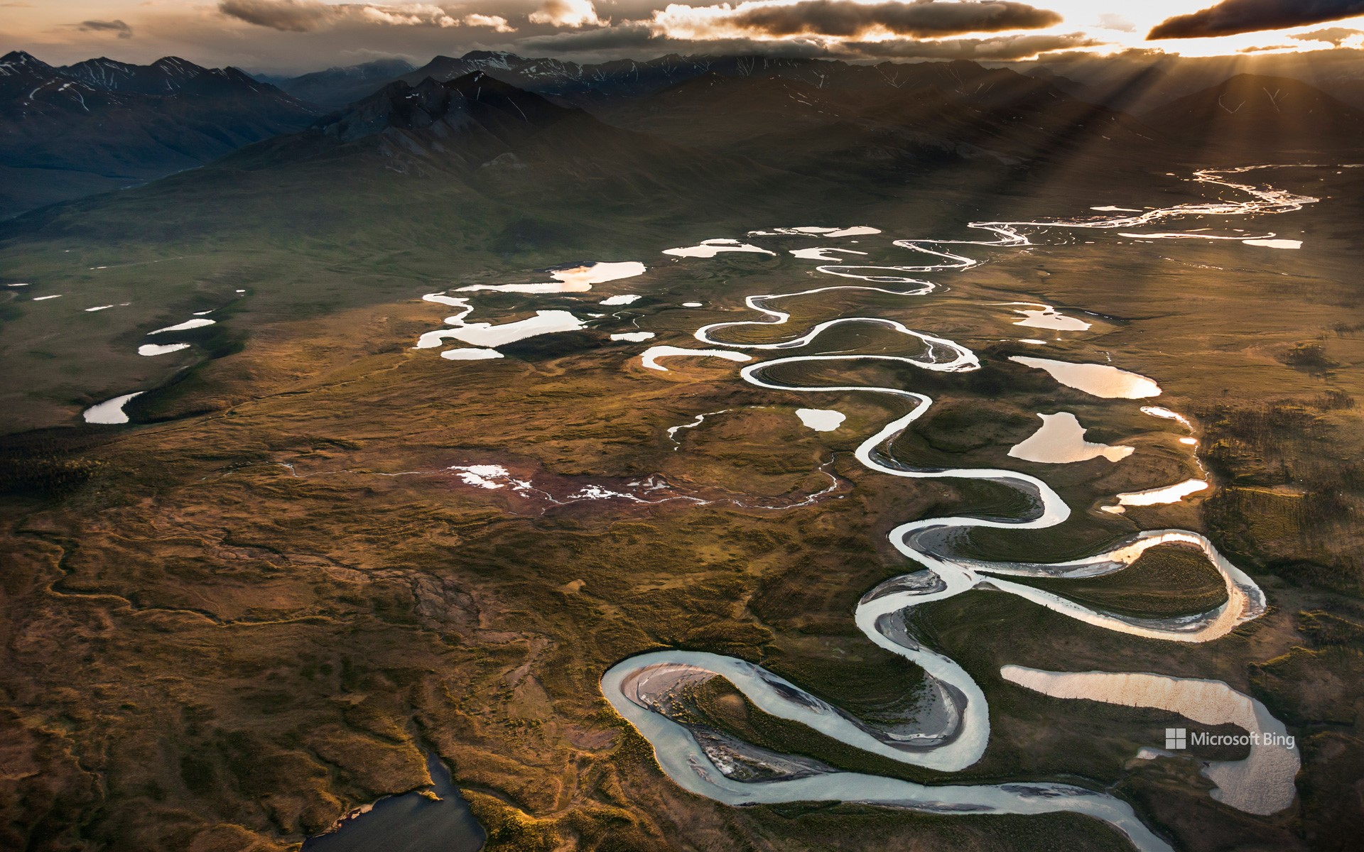
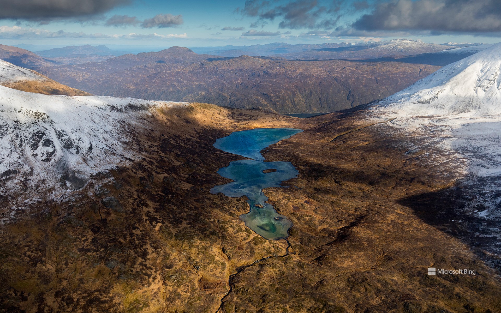
你是否想过美国那些野生河流是如何保持原始状态的?这要归功于《野生与风景河流法案》,它于1968年的今天被签署成为法律。这项立法还创建了国家野生与风景河流系统,旨在保护那些具有杰出的自然、文化以及休闲价值的特定河流,使其保持自由流动的状态。这个国家系统管理着40个州的209条河流,它们的总长超过12700英里,但不到美国350万英里河流的四分之一。在这个系统中,河流被分类为野生、风景或休闲河流。例如今天图片中看到的温德河就是一条野生河流,它尚处于孤立且未被开发的状态。这条85英里长的河流从菲利普·史密斯山脉流向昌达拉河的东支,蜿蜒穿过一个布满湖泊和湿地的河谷。作为北极国家野生动物保护区的一部分,这个河谷是一个繁荣的栖息地,居住着白大角羊、驼鹿、北美驯鹿、灰熊等动物。在这个充满变化的世界里,还有如此原生态的河流,真令人欣慰。
Wild and Scenic Rivers Act
Ever wonder how some of our rivers stay unspoiled? It's thanks to the Wild and Scenic Rivers Act, which was signed into law on this day in 1968. This legislation created the National Wild and Scenic Rivers System, which preserves rivers with exceptional natural, cultural, and recreational qualities.
The national rivers system oversees more than 13,000 miles of 228 rivers across 41 states and Puerto Rico, a tiny fraction of the 3.5 million miles of US rivers. It categorizes rivers as wild, scenic, or recreational. The Wind River in northeastern Alaska, seen in today's image, is a wild river, isolated and undeveloped. It flows for 85 miles, from the Philip Smith Mountains to the East Fork of the Chandalar River, winding through a valley filled with lakes and wetlands. Part of the Arctic National Wildlife Refuge, this river valley is a bustling habitat for Dall sheep, moose, caribou, and grizzly bears. In a changing world, it's comforting to know these rivers will remain unchanged.
复活节溪和基利克河的交汇处,北极之门国家公园,阿拉斯加州,美国 Confluence of Easter Creek and Killik River, Gates of the Arctic National Park, Alaska (© Patrick J. Endres/Getty Images)
复活节溪和基利克河的交汇处,北极之门国家公园,阿拉斯加州,美国 Confluence of Easter Creek and Killik River, Gates of the Arctic National Park, Alaska (© Patrick J. Endres/Getty Images)
河流的交汇 The meeting of the waters
国家河流月
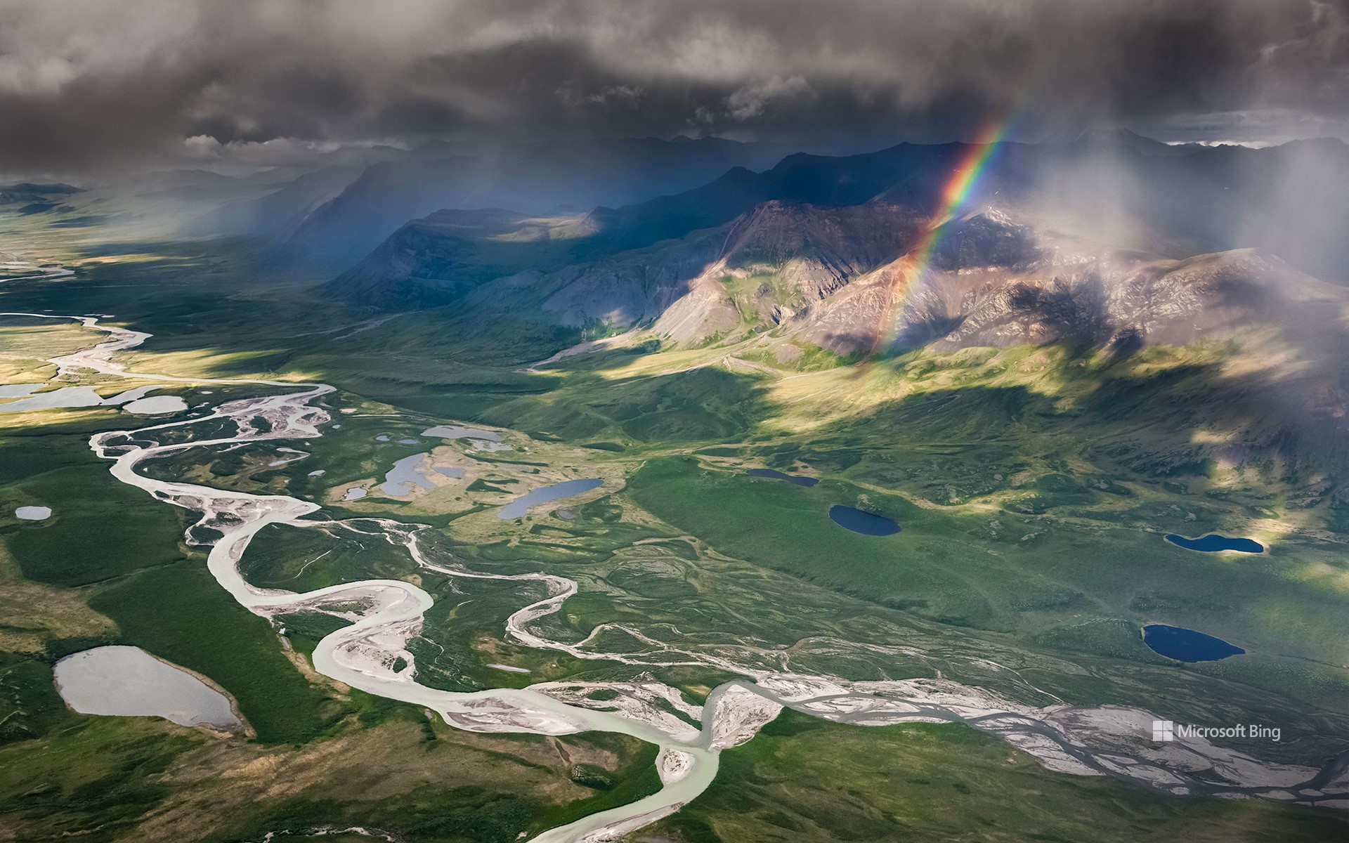
加拿大活动家马克·安吉洛发起了为期三十天的“国家河流月”活动,向地球脉络致敬。今天的图片展示的是阿拉斯加复活节溪和基利克河的交汇处,真是一幅美丽的画卷啊!和这些溪流一样,人们每年也会聚集在一起,为保护这些河流出力。随着污染、栖息地破坏和过度使用等情况日益加剧,倡导保护河流比以往任何时候都更加重要。无论你是在平缓的溪流中划桨,还是在垂钓时抛下鱼线,抑或只是沿着河岸悠闲地散步,都可以通过无数种方式与这些流动的奇迹建立联系。仅美国就拥有一个由25万多条河流组成的庞大河网,这些河流在不同的地形上绵延300多万英里。你想去参观哪条河呢?
National Rivers Month
The lush greenery of June is here, and so is National Rivers Month, a tribute to the veins of our planet, created by Canadian activist Mark Angelo. Just like the confluence featured here today, where Alaska's Easter Creek and Killik River unite in a beautiful display, we too come together every year to help preserve the nation's rivers. With increasing threats such as pollution, habitat destruction, and overuse, it's more important than ever to advocate for their protection. Whether you're paddling down a gentle stream, casting a fishing line, or simply enjoying a leisurely stroll along the riverbank, there are countless ways to connect with our waterways. The US alone boasts a vast network of over 250,000 rivers, stretching more than 3 million miles. Which one are you heading to?
座头鲸家族,荷兰港,阿拉斯加州 Family of humpback whales, Dutch Harbor, Alaska (© Jude Newkirk/Amazing Aerial Agency)
座头鲸家族,荷兰港,阿拉斯加州 Family of humpback whales, Dutch Harbor, Alaska (© Jude Newkirk/Amazing Aerial Agency)
希望的浪潮 Waves of hope
世界海洋日
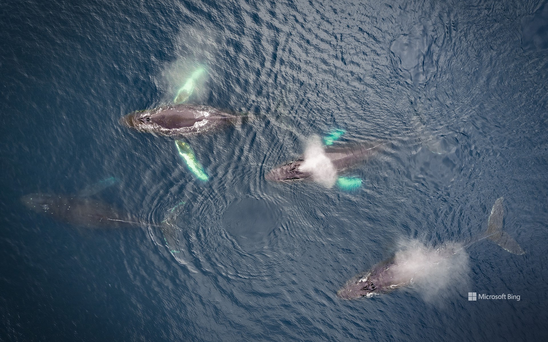
今天,在庆祝世界海洋日之际,让我们共同踏上一场海洋之旅吧!世界海洋日是为了纪念和保护世界上的海洋,提醒人们海洋在维持地球生命方面所发挥的关键性作用。毕竟,从最小的浮游生物到如图中所示的座头鲸一样巨大的鲸鱼,这些庞大的水体中充满了奇迹。由于浮游生物(微小的植物、藻类和细菌)的光合作用,海洋还产生了地球上近一半的氧气。此外,海洋还从大气中吸收大量的二氧化碳,这有助于减轻人类活动造成的气候变化影响。
海洋面临着许多威胁,包括全球变暖导致的海洋温度上升、塑料污染和海洋酸化,这威胁到许多海洋物种。今年世界海洋日的主题是“新深度唤醒”,这一口号鼓励我们深入探究海洋的复杂性,并积极采取行动,确保这些迷人的海洋动物世世代代继续为我们的星球增添光彩。那么,你准备好加入行动了吗?
World Oceans Day
Today, let's embark on a watery adventure for World Oceans Day, a celebration of the critical role played by oceans in supporting life on Earth. These gargantuan water bodies teem with wonders, from the tiniest plankton to the grandest whales, like the humpbacks we see here. The oceans also produce almost half of the oxygen on our planet thanks to the photosynthesis of plankton—tiny plants, algae, and bacteria. Moreover, they absorb carbon dioxide from the atmosphere, helping mitigate the impacts of climate change.
Oceans, and the marine species they support, face many threats, including rising sea temperatures thanks to global warming, plastic pollution, and ocean acidification. The theme for this year's World Oceans Day is 'Awaken New Depths.' This motto encourages us to delve deeper into the ocean's complexities and ensure that fascinating, ocean-dwelling animals, like our homepage whales, continue to grace our planet for generations to come. Are you ready to take the plunge?
科迪亚克国家野生动物保护区,科迪亚克岛,阿拉斯加州,美国 Kodiak National Wildlife Refuge, Kodiak Island, Alaska (© Ian Shive/Tandem Stills + Motion)
科迪亚克国家野生动物保护区,科迪亚克岛,阿拉斯加州,美国 Kodiak National Wildlife Refuge, Kodiak Island, Alaska (© Ian Shive/Tandem Stills + Motion)
西沃德的财富 Seward's fortune
科迪亚克国家野生动物保护区,阿拉斯加
1867年10月18日,在美国国务卿威廉·亨利·西沃德的谈判下,俄国将阿拉斯加的领土转让给了美国。美国一共花费了720万美元,以每英亩约两美分的价格买下了阿拉斯加地区,这一段历史被称为“阿拉斯加交易”。如今,这一天被称为阿拉斯加日,以纪念阿拉斯加丰富的历史、多元的文化、未开垦的荒野和坚忍不拔的精神。
1941年,在时任美国总统富兰克林·德拉诺·罗斯福的领导下,成立了科迪亚克国家野生动物保护区。位于阿拉斯加的科迪亚克岛的地理风貌复杂多样,不仅有绵延数百英里的海岸线,还有湖泊、湿地、沼泽和草原。岛上山峰高耸,峡湾和茂密的植被点缀其间,莎草、赤杨、云杉、绚烂的野花和美味的浆果随处可见。此外,岛上还有一种以科迪亚克岛的名字命名的野生动物,名叫科迪亚克熊,是棕熊中的最大亚种。
Alaska Day
On October 18, 1867, the Russian Empire transferred the territory of Alaska to the United States following negotiations by US Secretary of State William Seward. The US paid $7.2 million, or about 2 cents per acre, for the land, adding more than 586,0000 square miles to its territory. Today the date is known as Alaska Day and honors the history, untamed wilderness, and unwavering resilience of the state.
To mark the day, we are in the Kodiak National Wildlife Refuge, spread over several islands in the Kodiak Archipelago in southwestern Alaska. Our homepage image shows Kodiak Island, whose landscape includes hundreds of miles of shoreline as well as lakes, marshes, bogs, and meadows. Its towering mountains are home to fjord inlets and lush vegetation, including sedges, alders, spruces, wildflowers, and berries. A wild inhabitant of the islands, the Kodiak bear, the largest subspecies of brown bear, is named after the archipelago.
从德纳里山看福克拉山,德纳里国家公园,美国阿拉斯加州 Climber on Denali, Denali National Park, Alaska (© Andrew Peacock/Tandem Stills + Motion)
从德纳里山看福克拉山,德纳里国家公园,美国阿拉斯加州 Climber on Denali, Denali National Park, Alaska (© Andrew Peacock/Tandem Stills + Motion)
德纳里山的力量无可否认 There's no denying the power of Denali
美国登山日
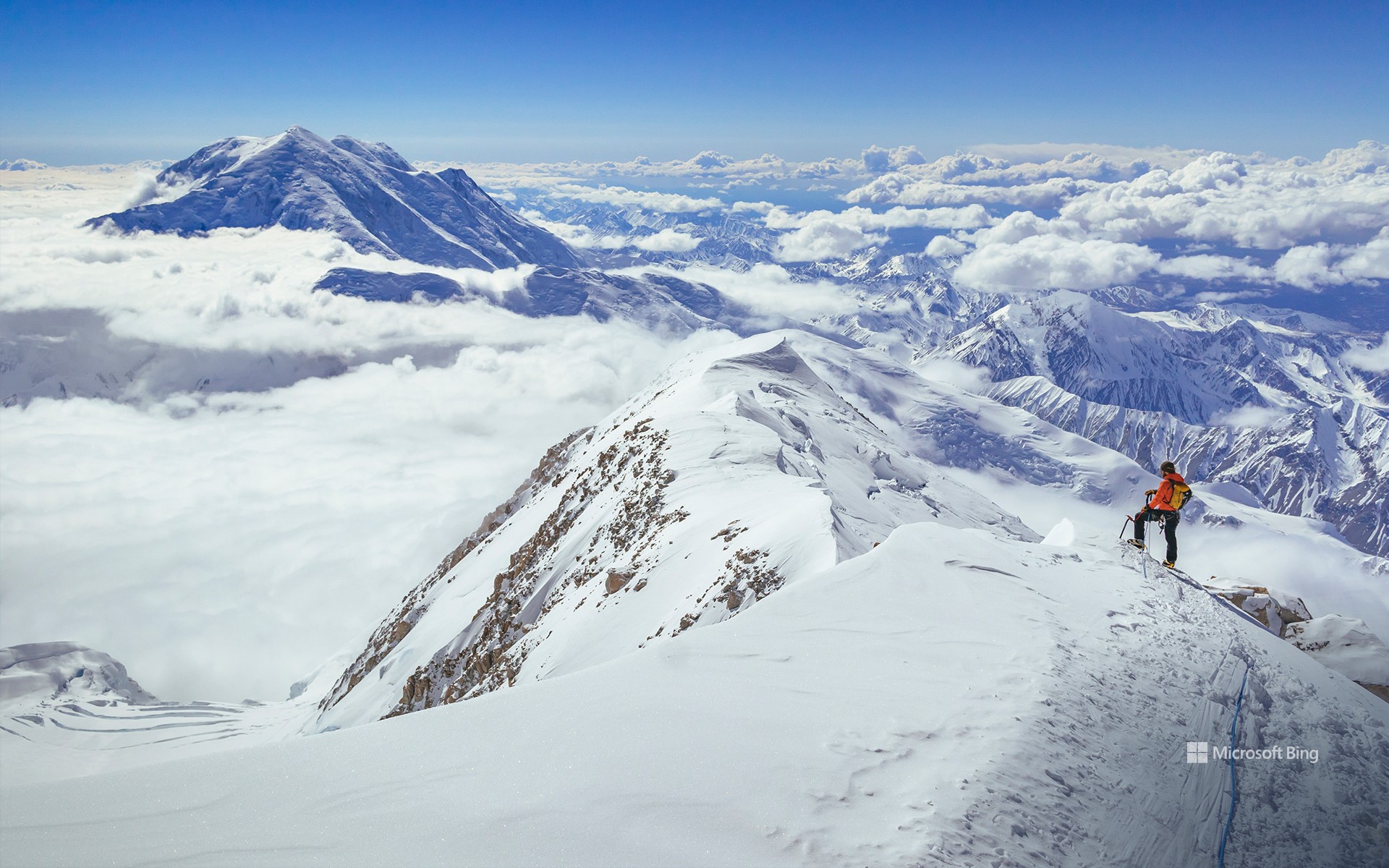
今天是美国登山日。为了攀登高峰和征服困难地形,登山者们需要专业的训练和丰富的经验,登山途中更是一段艰辛的旅程。但是,登上山顶俯瞰山下风景的那一刻,所有的艰辛都是值得的。今天图片中展示的是北美最高峰德纳里山,海拔超2万英尺,位于阿拉斯加的德纳里国家公园和保护区。“德纳里”一词源于阿萨巴斯卡语,是“至高者”的意思。
National Mountain Climbing Day
Today is National Mountain Climbing Day, dedicated to celebrating the sport while highlighting its many risks and rewards. In a bid to scale the tallest peaks and conquer difficult terrain around the world, mountain climbers embark on physically strenuous journeys that demand exceptional training and experience. But the panoramic views and sense of achievement after reaching the summit makes the effort worthwhile. Our image today is that of Denali, North America's highest peak at 20,310 feet, in south-central Alaska. The name 'Denali' means 'the high one' in the native Athabascan language. Four climbers, Walter Harper, Harry Karstens, Robert Tatum, and Hudson Stuck, were the first to set foot on the top of the mountain in 1913.
阿玛咖港, 阿拉斯加美国 Amalga Harbor, Alaska (© Mark Kelley/Tandem Stills + Motion)

阿玛咖港, 阿拉斯加美国 Amalga Harbor, Alaska (© Mark Kelley/Tandem Stills + Motion)
一切都很平静 All is calm
阿拉斯加阿玛咖港的圣诞节
“最后的边境”上的这个与世隔绝的小海湾是你最不可能看到圣诞树从头到脚装饰着闪闪发光的地方。阿玛咖港位于朱诺(美国为数不多的沿海州首府之一)以北约15英里处,这表明公众表达圣诞快乐的方式很少有局限性,可能包括使用小型驳船。这张照片拍摄于附近的欧内斯特·格鲁宁州历史公园,该公园以阿拉斯加州前州长的名字命名。格鲁宁在1939年至1953年领导该地区,1959年阿拉斯加成为该州的第一批美国参议员之一。在他的政治生涯结束后,他和妻子住在一间小屋里,这间小屋被作为这一历史遗迹的一部分保存下来。
Christmas in Amalga Harbor, Alaska
This isolated cove on 'the Last Frontier' is the least likely place you'd expect to find a Christmas tree decorated from head to toe with lights aglow. Amalga Harbor lies about 15 miles north of Juneau (one of the few coastal state capitals in the US) and shows that the public expression of Christmas cheer knows few limitations–and may include use of a small barge. This photograph was taken from nearby Ernest Gruening State Historical Park, which was named for the former governor of the Alaska Territory. Gruening led the territory from 1939 to 1953 before becoming one of the state's first US senators when Alaska became a state in 1959. After his political career ended, he and his wife lived in a cabin that was preserved as part of this historic site.
特里卡基拉河三角洲,阿拉斯加州克拉克湖国家公园,美国 Tlikakila River Delta in Lake Clark National Park, Alaska (© Dawn Wilson Photography/Getty Images)
特里卡基拉河三角洲,阿拉斯加州克拉克湖国家公园,美国 Tlikakila River Delta in Lake Clark National Park, Alaska (© Dawn Wilson Photography/Getty Images)
保护阿拉斯加的自然之美 Preserving Alaska's natural beauty
特里卡基拉河三角洲
1980年的这一天,历史上最大规模的保护地扩张使美国国家公园系统的规模扩大了一倍。在那之前,阿拉斯加没有国家公园,但现在该州有八个,加上众多的纪念碑和保护区,保护着超过1.57亿英亩的土地。当卡特总统签署《阿拉斯加国家利益土地保护法案》时,公众有权欣赏像今天照片中这样令人惊叹的地方:克拉克湖国家公园51英里长的特利卡基拉河的辫状河三角洲。
在当地的阿萨巴斯坎语中,Tlikakila字面意思是“鲑鱼在那里。”该公园以盛产鲑鱼的水道而闻名,因此,鱼类对当地经济和生态系统至关重要。当地的熊群从过量的鲑鱼中受益,在克拉克湖看熊很受欢迎。丰富的三文鱼也让公园里的狼群受益匪浅,这是世界上唯一一只只依赖三文鱼的狼群。
Tlikakila River Delta
On this day in 1980, the single largest expansion of protected lands in history doubled the size of the US National Park System. Prior to that day, Alaska had no national parks, but now the state has eight, plus numerous monuments and preserves that protect more than 157 million total acres. When President Carter signed the Alaska National Interest Lands Conservation Act, the public was granted the right to appreciate stunning locations like the one in today's photo: the braided river delta of the 51-mile long Tlikakila River in Lake Clark National Park.
In the native Athabaskan language, Tlikakila literally means 'salmon are there river.' The park is known for its salmon-laden waterways and, as such, the fish is of major importance to the local economy and ecosystem. Local bear populations benefit from the excess salmon, and bear watching is very popular at Lake Clark. The abundance of salmon has also benefited a wolf pack within the park—the only one in the world known to be solely dependent on salmon.
楚科奇海的浮游植物水华,美国阿拉斯加州海岸附近 Blooms of phytoplankton in the Chukchi Sea off the coast of Alaska (© Norman Kuring/Kathryn Hansen/U.S. Geological Survey/NASA)
楚科奇海的浮游植物水华,美国阿拉斯加州海岸附近 Blooms of phytoplankton in the Chukchi Sea off the coast of Alaska (© Norman Kuring/Kathryn Hansen/U.S. Geological Survey/NASA)
什么生长得这样茂盛? What's blooming so brightly?
楚科奇海浮游植物的大量繁殖
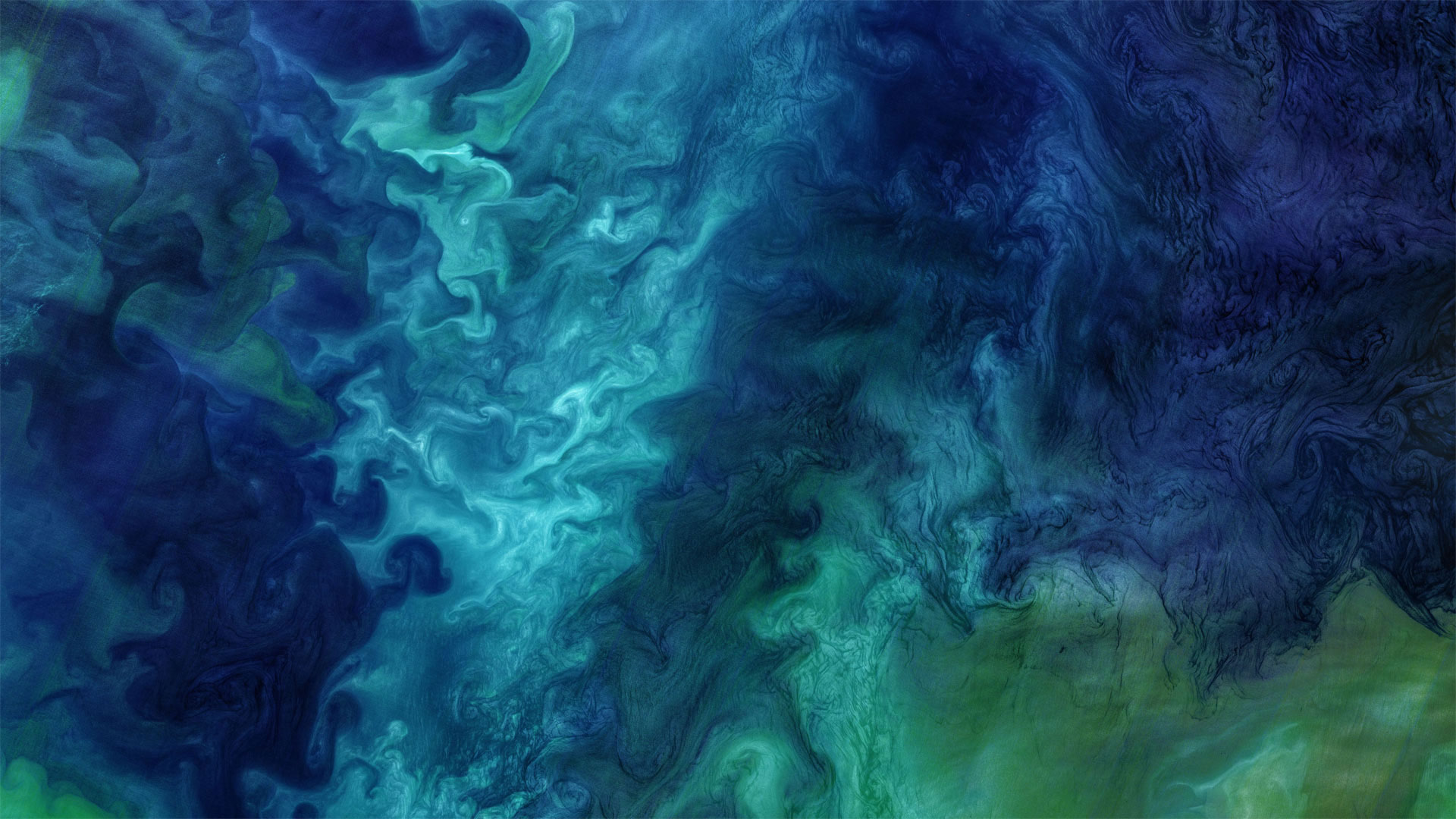
在这张酷酷的照片中,数百种深浅的蓝色被大理石镶嵌在一起。不,这不是一件现代艺术作品,它是大自然的杰作。这是一张卫星照片,照片中的浮游植物在阿拉斯加附近盛开,凉爽、咸的楚科奇海与靠近海岸的温暖、新鲜的海水混合在一起。
但究竟什么是浮游植物?它们是微小的太阳能生物,漂浮在海面附近,随洋流漂流。事实上,它们的名字来源于希腊语中植物的“phyton”和流浪者或漂泊者的“planktos”。对于生活在海洋和河口的各种生物来说,浮游植物既美味又营养,对地球上的每一个人都至关重要:浮游植物的光合作用约占世界光合作用的一半,是吸收二氧化碳和释放氧气的太阳能过程。
今天我们谈论浮游植物是为了纪念地球科学周,这是一个鼓励我们所有人学习甚至献身于地球科学的国际活动。今年的主题是“地球科学促进可持续发展世界”,强调科学在维持我们的星球上的作用。所以,是时候掸掉显微镜上的灰尘,参观当地的科学博物馆,或者也许只是了解更多关于美丽的旋转浮游植物的知识。
Blooms of phytoplankton in the Chukchi Sea
Hundreds of shades of blue are marbled together in this cool shot. No, it's not a work of modern art, it's right off the brush of nature. This is a satellite photo of phytoplankton blooming near Alaska as the cool, salty Chukchi Sea mingles with warmer, fresher water closer to shore.
But just what are phytoplankton? They're microscopic sun-powered organisms that float near the surface of the ocean, drifting with the currents. In fact, their name derives from the Greek 'phyton' for plant and 'planktos' for wanderer or drifter. Delicious and nutritious to various creatures living in oceans and estuaries, they're also vital to everyone on Earth: Phytoplankton are responsible for about half of the world's photosynthesis, the sun-powered process that takes in carbon dioxide and releases oxygen.
We're talking phytoplankton today in honor of Earth Science Week, an international event encouraging all of us to learn about or even devote our life to the Earth sciences. This year's theme is 'Earth Science for a Sustainable World,' emphasizing science's role in sustaining our planet. So, time to dust off that microscope, visit your local science museum, or perhaps just learn more about beautiful, swirling phytoplankton.
两头穿越苏西特纳河的驯鹿,美国阿拉斯加 Caribou crossing the Susitna River during the autumn rut, Alaska (© Tim Plowden/Alamy)
两头穿越苏西特纳河的驯鹿,美国阿拉斯加 Caribou crossing the Susitna River during the autumn rut, Alaska (© Tim Plowden/Alamy)
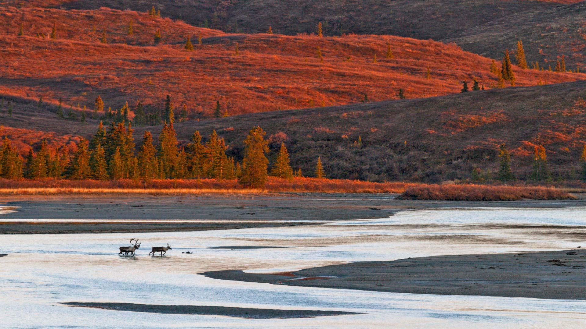
令人印象深刻的时刻 Time to make an impression
Caribou rutting season in Alaska
It's that time of year when Alaskan caribou are beginning to feel a little frisky. From late September until early November, males will be strutting their stuff, locking antlers with one another, and competing for the attention of females in hopes of furthering the species. Successful males will mate with 15-20 females a season. After the rutting season males will shed their antlers while females keep theirs until spring. In today's photo we're looking at some caribou in southcentral Alaska crossing the Susitna River.
Alaska has 32 distinct caribou herds. It's likely today's caribou are members of the Nelchina herd, which roams across about 20,000 square miles in the high basin surrounded by the Talkeetna, Chugach, Wrangell, and Alaska ranges. The Nelchina herd is among the most studied and recognized of Alaskan caribou partly because their range is relatively close to the major human population centers of the state. The herd has provided food for Alaskans for hundreds of years and its population is maintained through carefully monitored hunting regulations. But caribou populations can fluctuate from one year to the next depending on the availability of food and severity of the weather.
阿拉斯加驯鹿发情季节
每年的这个时候,阿拉斯加驯鹿开始感到有点活泼。从9月下旬到11月初,雄性将昂首阔步,相互锁住鹿角,争夺雌性的注意力,以期进一步丰富物种。成功的雄性每季度将与15-20只雌性交配。发情期过后,雄性会脱掉鹿角,而雌性会一直保留到春天。在今天的照片中,我们看到一些驯鹿在阿拉斯加中南部穿越苏西特纳河。
阿拉斯加有32个不同的驯鹿群。今天的北美驯鹿很可能是Nelchina鹿群的成员,它们在塔基特纳山脉、楚加赫山脉、朗格尔山脉和阿拉斯加山脉环绕的高盆地中漫游,占地约20000平方英里。Nelchina驯鹿群是阿拉斯加驯鹿中研究和认识最多的驯鹿群之一,部分原因是它们的分布范围相对接近该州的主要人口中心。数百年来,牧群一直为阿拉斯加人提供食物,通过仔细监测狩猎法规来维持种群数量。但是驯鹿的数量可能会随着食物的供应和天气的恶劣程度而在一年到另一年之间波动。