标签 美国 下的文章
拱门国家公园双拱门映衬下的银河,犹他州,美国 The Milky Way framed by Double Arch in Arches National Park, Utah (© Adventure_Photo/Getty Images)
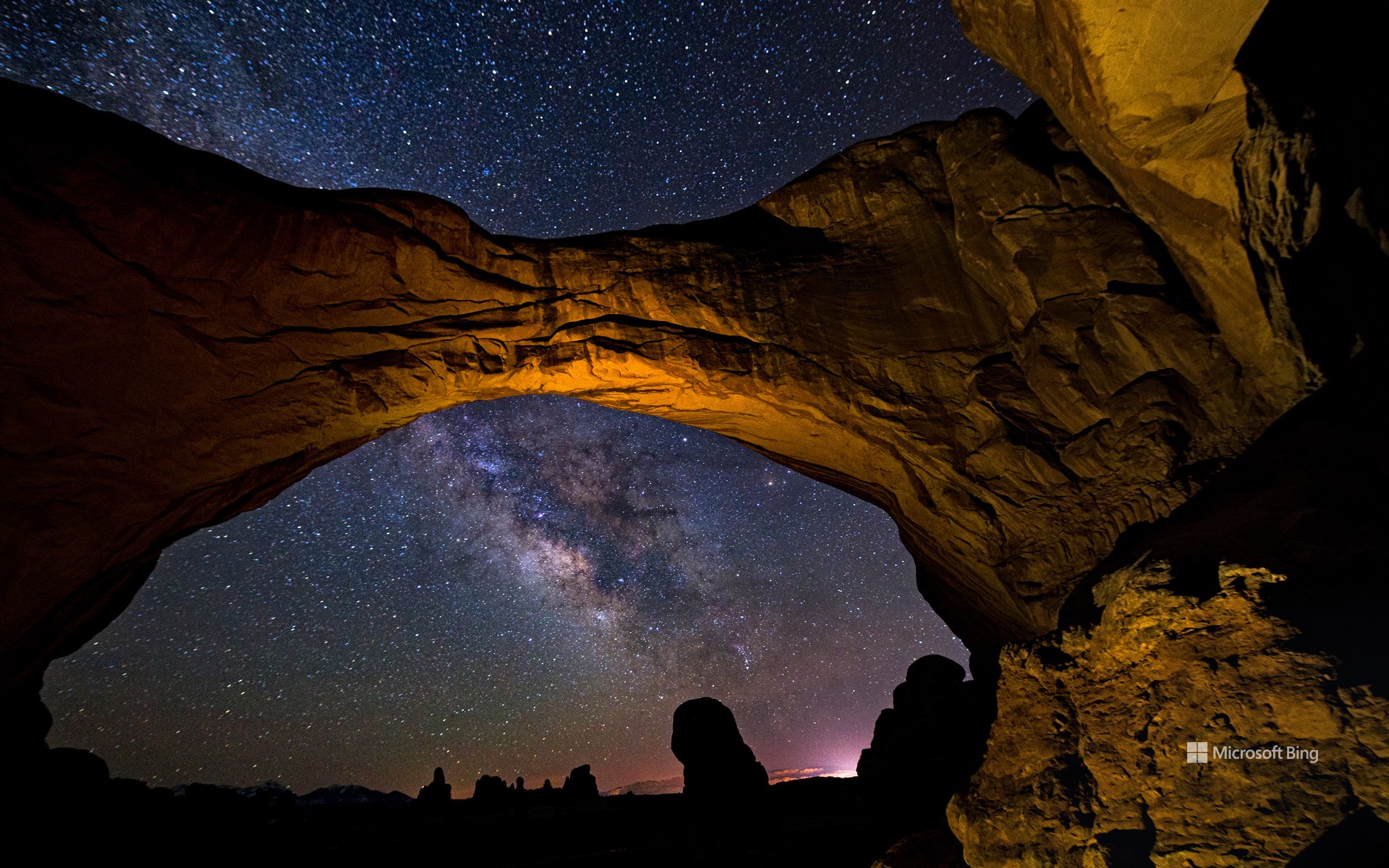
拱门国家公园双拱门映衬下的银河,犹他州,美国 The Milky Way framed by Double Arch in Arches National Park, Utah (© Adventure_Photo/Getty Images)
让我们一起庆祝宇宙 Let's celebrate the cosmos
国际天文日快乐!
你是否曾好奇,通过望远镜看到的土星环是什么样子?又或者,天文学家是如何发现遥远星系的?国际天文日正是探索这些奥秘的绝佳时机!这一年度活动最早于 1973 年发起,其官方主题是:“将天文学带给大众”。 从当地公园到天文俱乐部、博物馆,再到天文台,游客们可以参与望远镜观测、太空讲座,甚至体验模拟月球重力的装置!这一想法起源于加利福尼亚的一位天文学家道格·伯杰。他不再等待人们走进天文台,而是直接把望远镜带到热闹的公共场所。这一招奏效了,人们很快就迷上了仰望星空!如今,世界各地都在庆祝国际天文日,加拿大、瑞典、阿根廷等许多国家都有举办相关活动。今天,就是探索宇宙的好时机。找一架望远镜,一起仰望星空、庆祝宇宙的壮丽吧!
Happy International Astronomy Day!
Ever wondered what Saturn's rings look like through a telescope? Or how astronomers spot distant galaxies? International Astronomy Day is the perfect time to find out. This annual event, first launched in 1973, is all about 'Bringing Astronomy to the People'—the official theme of Astronomy Day. From local parks to astronomy clubs, museums, and observatories, visitors can enjoy activities like telescope viewings, space talks, and even moon gravity simulators.
The event started when Doug Berger, an astronomer in California, decided to take telescopes to busy public spaces rather than wait for people to visit observatories. It worked—people got hooked on stargazing. Astronomy Day is celebrated worldwide, with events in countries like Canada, Sweden, and Argentina, among many others. Today is the day to explore the universe. Find a telescope and celebrate the cosmos!
红木国家公园和州立公园, 加利福尼亚州, 美国 Grove of redwoods in Redwood National and State Parks, California (© Bob Pool/Getty Images)
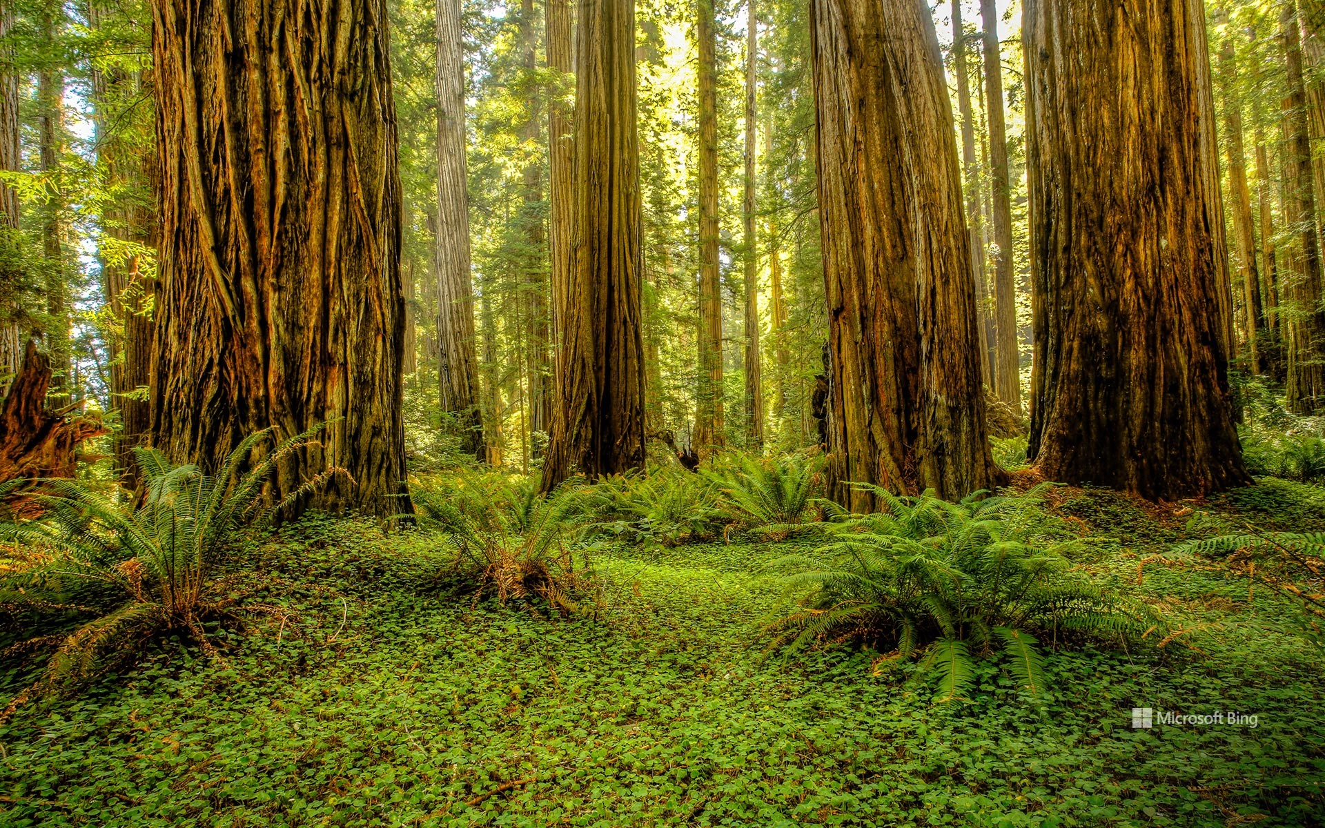
红木国家公园和州立公园, 加利福尼亚州, 美国 Grove of redwoods in Redwood National and State Parks, California (© Bob Pool/Getty Images)
就在这里驻足吧 Park it here
红木国家公园和州立公园, 加利福尼亚州
国家公园周今天落下帷幕,但这些森林已经庆祝大自然数千年了。走进一个树木直插云霄的世界。位于加利福尼亚州红木国家公园和州立公园的红木林,是地球上最高的树木之一,高达超过 370 英尺。州立公园包括红木国家公园、德尔诺特海岸红木州立公园、杰迪戴亚·史密斯红木州立公园和草原溪红木州立公园。有些红木树在玛雅人建造神庙和中国修建长城时就已经存在了。自 1968 年起被保护,这座公园保留了全球近一半现存的原始红木森林。
漫步于杰迪戴亚·史密斯红木州立公园的斯托特林地或红木国家公园的“第一夫人”林地中,能在红木树间享受宁静的漫步时光。您还可以徒步探索仅凭许可证才能进入的“高树小径”,在那里可以近距离观赏到这些最高的树木。红杉国家公园的生态系统是许多动物的家园,包括罗斯福麋鹿、黑熊、香蕉蛞蝓以及濒危的云雀鹱。在郁郁葱葱的树冠下,蕨类植物和苔藓茂盛生长,而沿海的雾气则为这些树木提供了不可缺少的水分。无论是徒步穿越这些参天巨树之间,还是仅仅站在它们的树荫下,这种体验都会令人感到心生敬畏。
Redwood National and State Parks, California
Step into a world where trees touch the sky. The redwood groves of Redwood National and State Parks (RNSP) in California are home to some of the tallest trees on Earth, soaring over 370 feet high. The combined RNSP contain Redwood National Park, Del Norte Coast Redwoods State Park, Jedediah Smith Redwoods State Park, and Prairie Creek Redwoods State Park. Some of these redwoods were alive when the Mayans built their temples, and the Great Wall of China was under construction. Protected since 1968, the park preserves nearly half of the world's remaining old-growth redwoods.
Walk through Stout Grove in Jedediah Smith Redwoods State Park or Lady Bird Johnson Grove in Redwood National Park for a quiet stroll among the redwoods. You can also hike the Tall Trees Trail, a permit-only path where you can closely witness the tallest trees. The RNSP ecosystem is home to many animals, including Roosevelt elk, black bears, banana slugs, and the endangered marbled murrelets. Ferns and moss thrive beneath the leafy canopy, while coastal fog provides essential moisture to the trees. Whether hiking beneath these towering giants or simply standing in their shadows, the experience is humbling.
阿拉斯加基奈峡湾国家公园尖顶湾, 阿拉斯加州苏厄德, 美国 Spire Cove in Kenai Fjords National Park, Seward, Alaska (© Wander Photography/Getty Images)
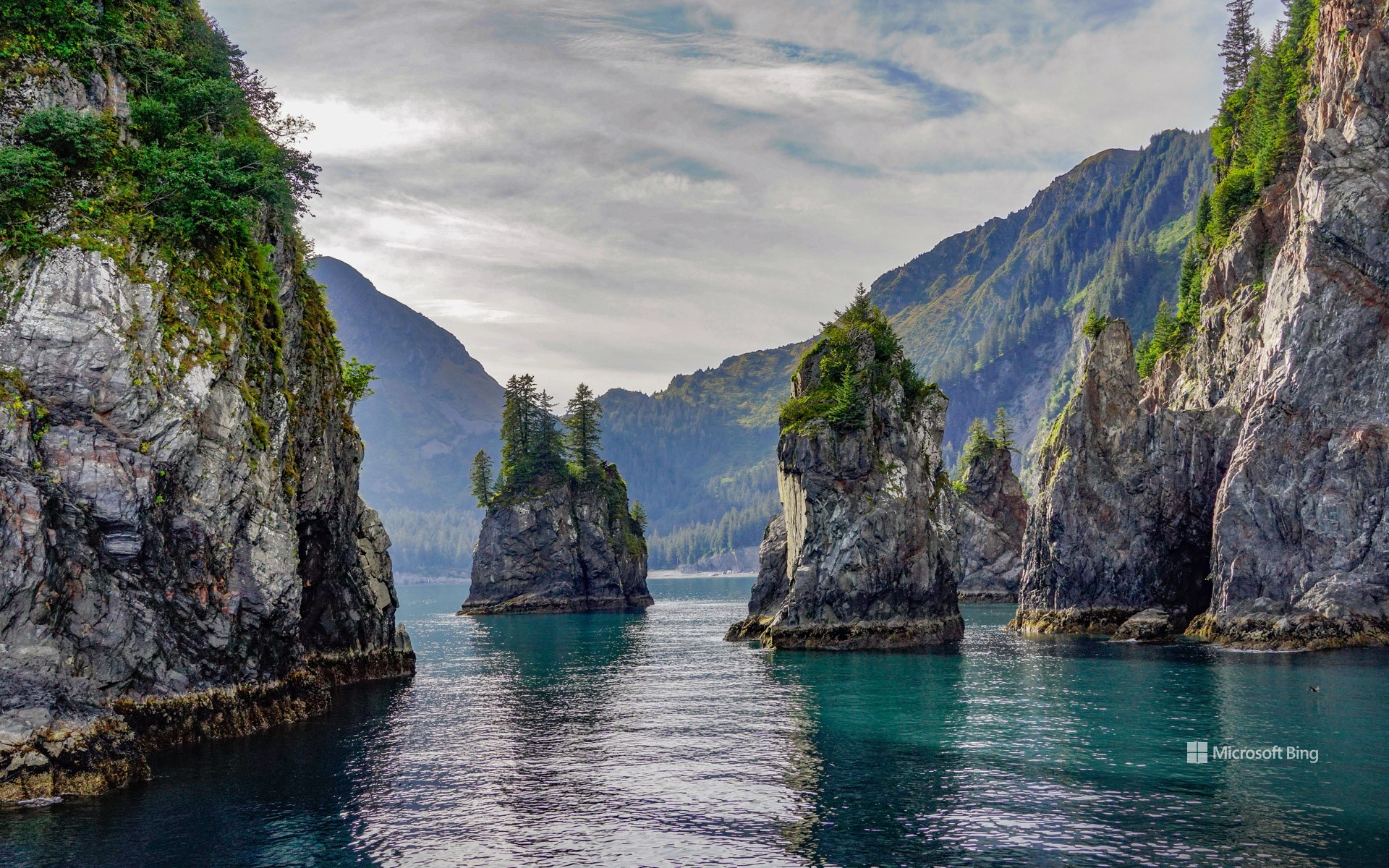
阿拉斯加基奈峡湾国家公园尖顶湾, 阿拉斯加州苏厄德, 美国 Spire Cove in Kenai Fjords National Park, Seward, Alaska (© Wander Photography/Getty Images)
崎岖山峰与野性水域 Rugged peaks and wild waters
阿拉斯加基奈峡湾国家公园尖顶湾, 阿拉斯加州苏厄德
随着国家公园周的持续进行,让我们把目光转向阿拉斯加基奈半岛上的瑰宝——基奈峡湾国家公园。该公园面积超过1,000 平方英里,拥有高耸的峡湾、蜿蜒的河谷和高山地貌。其中超过一半的区域被冰雪覆盖,冰川占据了其面积的 51%。在 20 世纪,公园内的冰川不断消退,为植物和动物的生长腾出了新的土地。从古老的西加云杉到娇嫩的柳兰幼苗,再到覆盖森林地面的茂密苔藓,尽管地势崎岖,基奈峡湾的植物依然繁茂生长。该公园也是多种陆地和海洋哺乳动物的栖息地,包括森林狼、豪猪、加拿大猞猁,以及虎鲸和长须鲸等鲸目动物。这里还栖息着多种鸟类,如白头海雕和皮尔氏游隼。
基奈峡湾国家公园不仅有令人惊叹的自然景观和繁茂的荒野,还蕴藏着丰富的人类历史。几千年来,阿拉斯加原住民在此生活,留下了他们生活的痕迹。在国家公园的范围内,过去依然留下印记,从沿海分布的苏格皮亚克人(阿拉斯加原住民一族)营地,到努卡湾中废弃的旧矿营遗迹。这些历史的足迹和公园的自然奇观一样珍贵,为我们提供了与曾塑造这片土地的人们之间的重要连接。有如此丰富的内容可供探索,难怪基奈峡湾是该州最受欢迎的公园之一。
Spire Cove in Kenai Fjords National Park, Seward, Alaska
As National Park Week rolls on, let's turn our attention to Kenai Fjords National Park, a gem on Alaska's Kenai Peninsula. Stretching over 1,000 square miles, this landscape features fjords, river valleys, and alpine landscapes. More than half of the terrain is blanketed in ice. Throughout the 20th century, the park's glaciers have receded, uncovering new land for plant and animal life to take root. From ancient Sitka spruces to delicate fireweed shoots and moss carpeting the forest floor, plant life in Kenai Fjords flourishes. The park is also home to diverse terrestrial and marine mammals, including timber wolves, porcupines, Canadian lynxes, and cetaceans like orcas and fin whales. It also hosts a variety of birds, such as bald eagles and Peale's peregrine falcons.
Kenai Fjords isn't just about stunning landscapes and flourishing wilderness—it's also a place rich with human history. For thousands of years, Alaska Natives have called this region home, leaving behind traces of their lives in the land. Within the national park, the past still lingers—from the camps left by Alaska Native Sugpiaq people once scattered along the coastline to the remnants of old mining camps in Nuka Bay.
大棱镜彩泉,黄石国家公园,怀俄明州,美国 Grand Prismatic Spring, Yellowstone National Park, Wyoming (© Ajith Kumar/Getty Images)
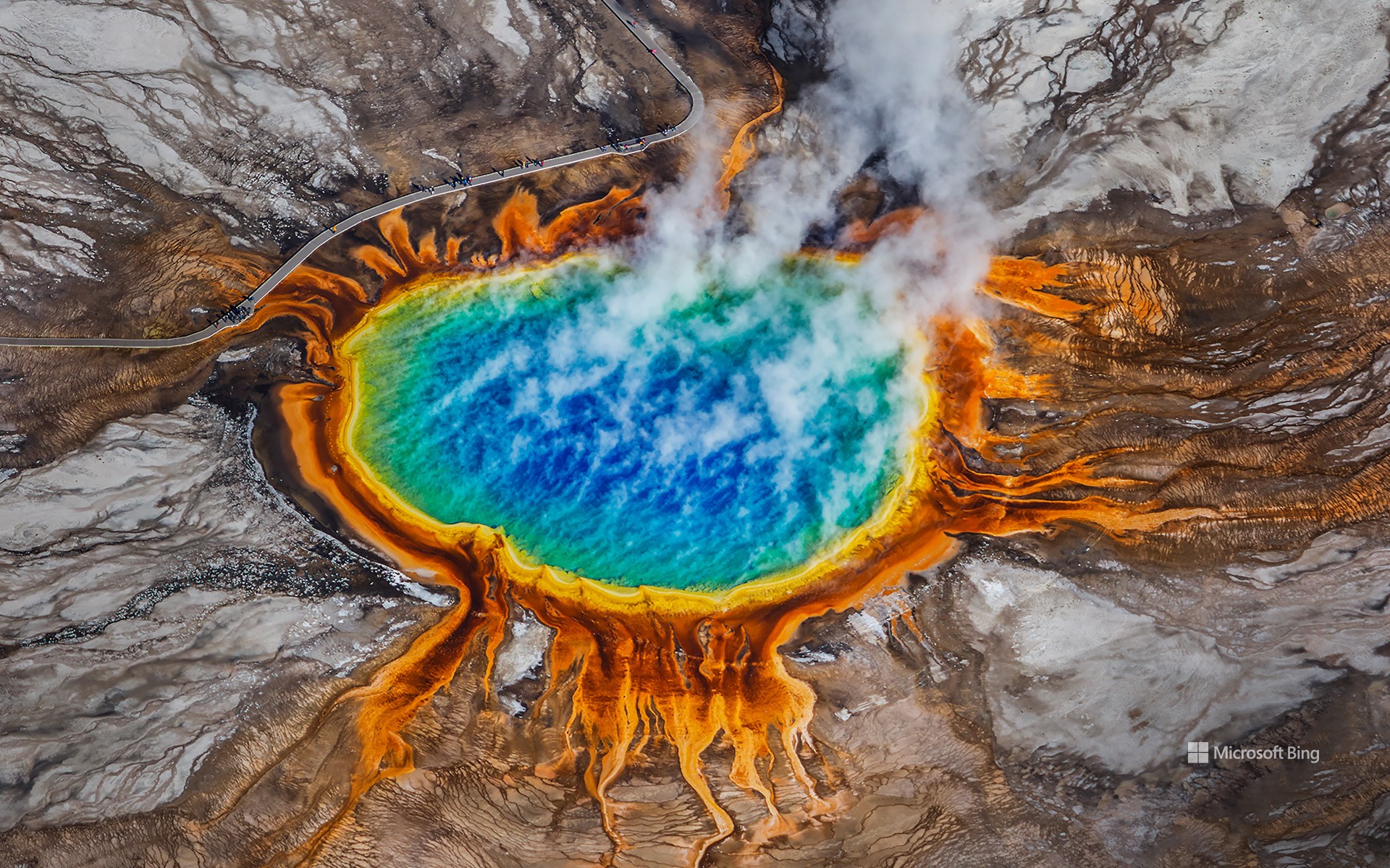
大棱镜彩泉,黄石国家公园,怀俄明州,美国 Grand Prismatic Spring, Yellowstone National Park, Wyoming (© Ajith Kumar/Getty Images)
我们的能源,我们的星球 'Our Power, Our Planet'
世界地球日
在地球日这一天,让我们前往大自然最壮观的地热奇观之一,位于美国怀俄明州黄石国家公园的大棱镜温泉。这是美国最大的温泉,直径达 370 英尺,水温高达 160 华氏度。这一地热奇观由地表下巨大的黄石火山所产生的强大热能驱动。温泉中色彩斑斓的蓝色、绿色、黄色和橙色环带是由生活在富含矿物质的热水中的嗜热微生物(称为嗜热菌)所形成的。
黄石的地热活动不仅为间歇泉和温泉提供动力,也为可持续能源提供了一个范例。与化石燃料不同,地热能是一种持续且可再生的能源。在我们庆祝地球日之际,“我们的能源,我们的星球”这一主题强调了寻找更清洁能源解决方案的必要性。黄石国家公园的地热力量展示了地球尚未开发的巨大潜能,这一潜力有助于减少碳排放并应对气候变化。大棱镜温泉提醒着我们,我们的星球蕴含着巨大的能量。关键在于如何明智地使用它,为可持续的未来努力。
Earth Day
On Earth Day, let's journey to one of nature's most stunning displays of geothermal power—Grand Prismatic Spring in Yellowstone National Park, Wyoming. The largest hot spring in the US, it spans 370 feet across and reaches temperatures of 160°F. This geothermal marvel is fueled by the immense heat of the massive Yellowstone volcano beneath the surface. Its vivid rings of blue, green, yellow, and orange are created by heat-loving microorganisms—called thermophiles—that thrive in the mineral-rich waters.
Yellowstone's geothermal activity not only fuels its geysers and hot springs, but also demonstrates a model for sustainable energy. Unlike fossil fuels, geothermal energy provides a continuous and renewable energy source. As we celebrate Earth Day, the theme 'Our Power, Our Planet' highlights the need for cleaner energy solutions. Yellowstone National Park's geothermal forces showcase Earth's untapped potential—one that could help reduce carbon emissions and combat climate change. The Grand Prismatic Spring serves as a reminder that our planet holds immense power. The challenge is using it wisely for a sustainable future.
银河下的约书亚树,加利福尼亚州,美国 Joshua trees under the Milky Way, California (© Chao Zhang/Getty Images)
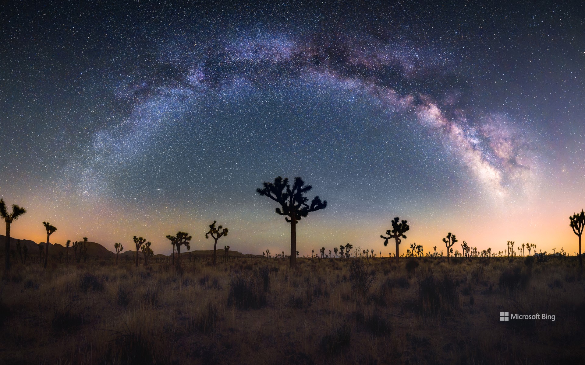
银河下的约书亚树,加利福尼亚州,美国 Joshua trees under the Milky Way, California (© Chao Zhang/Getty Images)
银河的魔力之下 Under the spell of the Milky Way
国际暗黑周
想象一下,站在一片漆黑的天空下,银河像一条发光的丝带横跨天际。这正是“国际暗黑周”希望带给我们的体验。每年四月,在新月周(今年是4 月 21 日至 27 日)期间,人们被邀请关闭灯光,仰望星空。这项活动由高中生詹妮弗·巴洛于2003 年发起,旨在对抗光污染。体验夜空之美的最佳地点之一是位于加利福尼亚州东南部的约书亚树国家公园,这是一个国际黑暗公园。在这里,由于没有人工光源的干扰,游客可以看到我们的祖先曾经看到过的星星。你知道吗?光污染使我们无法看到银河系中的大多数星星。通过减少光污染,我们可以重新与宇宙的美丽和神奇建立联系。
International Dark Sky Week
Imagine standing under a sky so dark that the Milky Way stretches across it like a luminous ribbon. This is the experience that International Dark Sky Week aims to bring back. Every April, during the week of the new moon (this year from April 21 to 27), we are invited to turn off our lights and gaze at the stars. The event was initiated by Jennifer Barlow, a high school student in 2003, to combat light pollution. One of the best places to experience the night sky's beauty is Joshua Tree National Park in southeastern California, an International Dark Sky Park. Here, the absence of artificial light allows visitors to see the stars as our ancestors once did. Did you know that light pollution prevents us from seeing most of the stars in the Milky Way? By reducing it, we can reconnect with the universe's beauty and wonder.
锡安国家公园,犹他州,美国 (© Simon Dannhauer/Getty Images)
锡安国家公园,犹他州,美国 (© Simon Dannhauer/Getty Images)
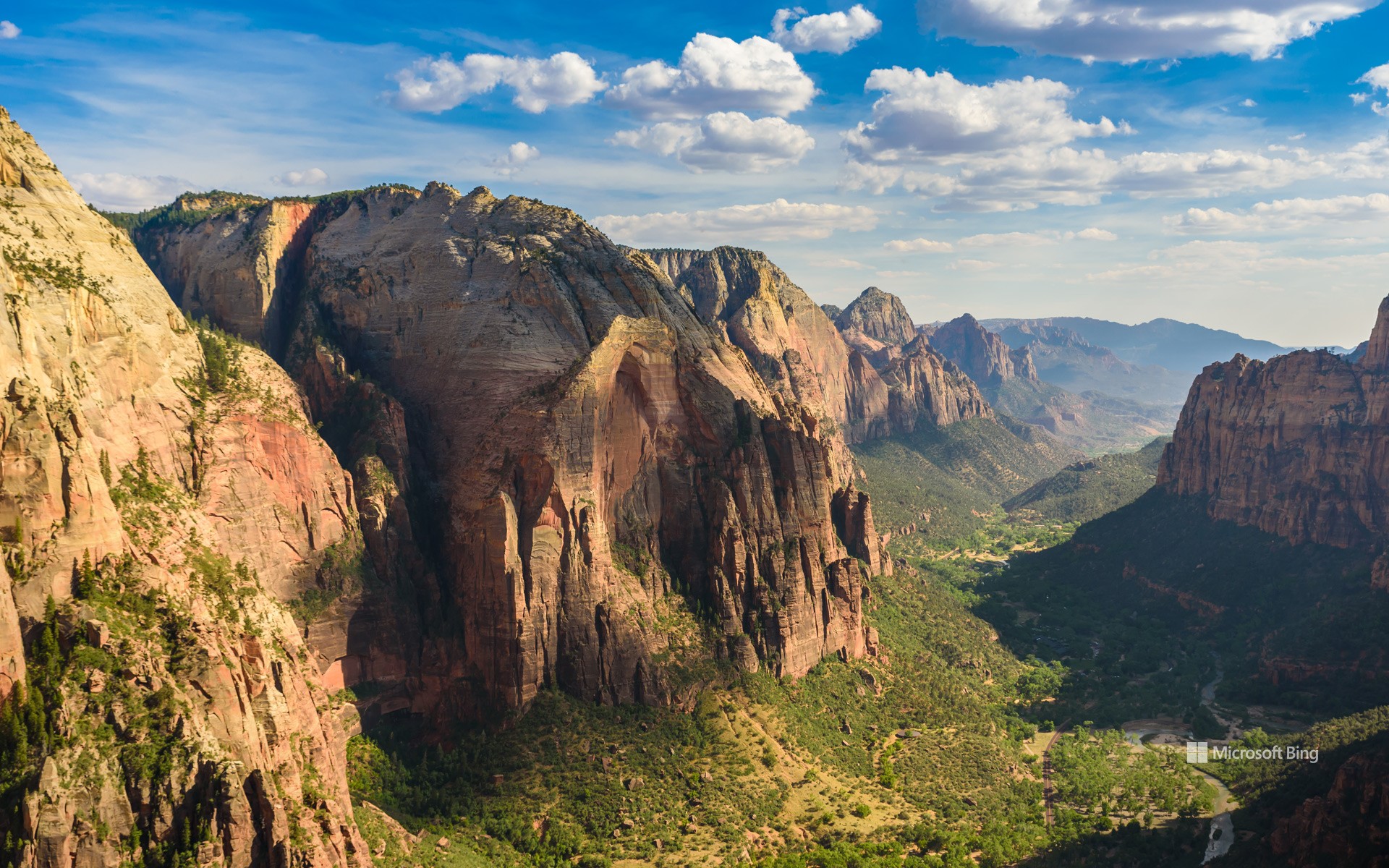
国家公园周开始了
锡安国家公园,犹他州,美国
穿上你的登山靴——国家公园周开始了!这个为期九天的活动从今天开始,鼓励人们探索并欣赏国家公园的自然美景与文化遗产。这是一个了解这些受保护区域、参与保护工作、并享受壮丽景观的绝佳时机。可以通过参观国家公园、分享这些自然宝藏的信息,来加入这一庆祝活动,同时也感受它们在国家遗产中所扮演的重要角色。
今日图片展示的是锡安国家公园,这是一个很好的起点。该公园位于犹他州西南部,占地232 平方英里,地貌独特,拥有壮观的砂岩悬崖和狭窄的缝隙峡谷。锡安国家公园拥有丰富的动植物资源,包括近 300 种鸟类和19 种蝙蝠。是不是很吸引人?锡安国家公园只是全美 400 多个国家公园中的一个。国家公园周是一个深入了解它们并亲近大自然的绝佳机会。
卡奇纳桥,天然桥国家区,犹他州,美国 Kachina Bridge, Natural Bridges National Monument, Utah (© Alan Majchrowicz/Getty Images)
卡奇纳桥,天然桥国家区,犹他州,美国 Kachina Bridge, Natural Bridges National Monument, Utah (© Alan Majchrowicz/Getty Images)
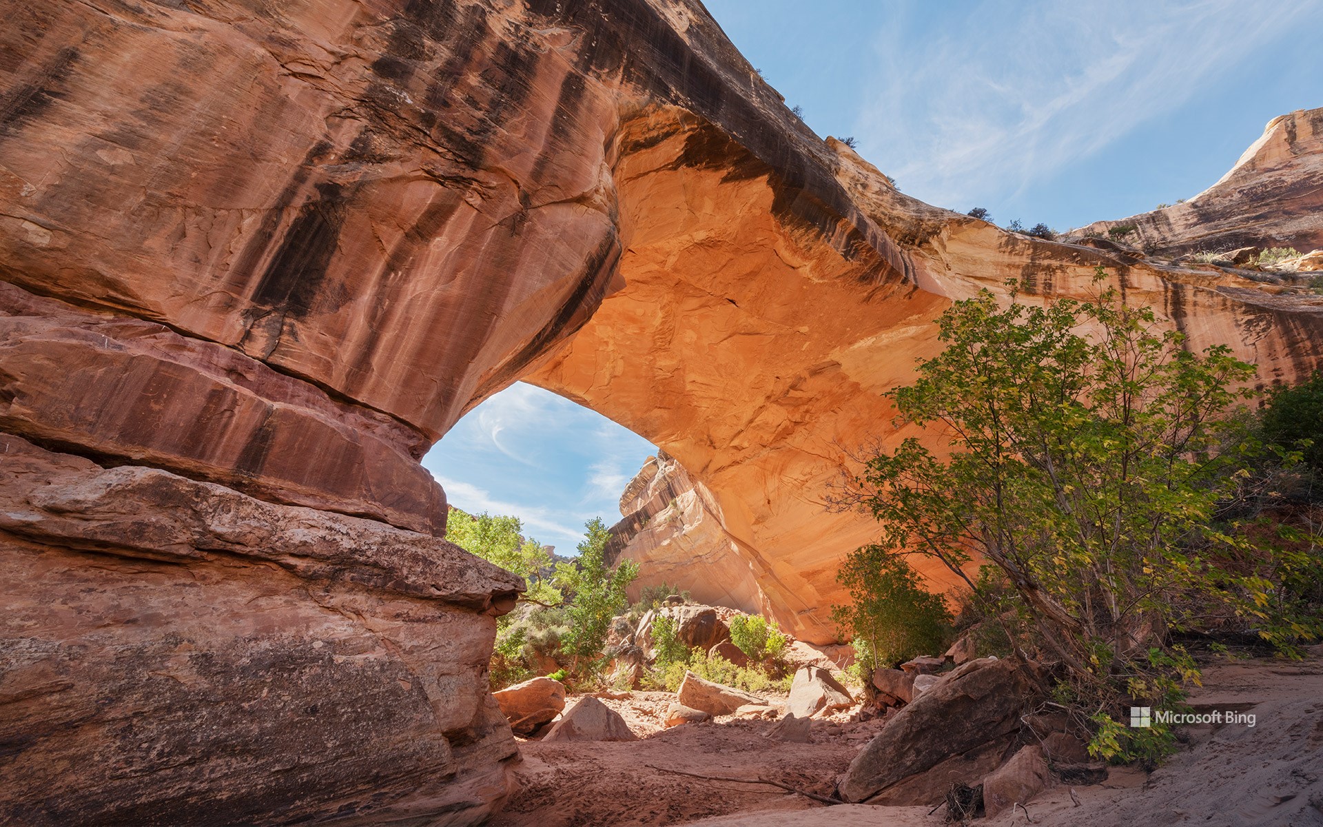
时光通道 A passage through time
纪念天然桥国家保护区成立周年,犹他州
在犹他州东南部偏远的峡谷深处,天然桥国家保护区静静地诉说着时间与自然的力量。这里坐落着三座壮丽的天然桥:西帕普桥、卡奇纳桥和欧瓦乔莫桥。这些名字来源于曾在此生活的阿纳萨齐祖先印第安人,向他们的文化遗产致敬。其中,西帕普桥是最大的一座,其巨大的桥洞足以容纳美国国会大厦的圆顶。位于西帕普和欧瓦乔莫之间的卡奇纳桥,以桥基处发现的岩画和壁画而得名。而欧瓦乔莫桥被认为是三座桥中最古老的一座,其纤细的拱形结构表明它可能最终会自然坍塌。
1908年的今天,美国总统西奥多·罗斯福宣布此地为犹他州首座国家纪念地,以保护这一奇观。如今,这片神秘而壮丽的土地依旧保持着原始风貌。游客可以沿着小径徒步穿行,在高耸的天然桥下驻足仰望,感受大自然鬼斧神工的杰作,或是在这片以漆黑夜空闻名的保护区里,欣赏璀璨银河铺满天际的壮观景象。
Anniversary of Natural Bridges National Monument, Utah
Within the remote canyons of southeastern Utah, Natural Bridges National Monument highlights the power of erosion and the passage of time. Shaped by the relentless forces of wind and water, this monument features three magnificent natural bridges—Sipapu, Kachina, and Owachomo. These bridges were named to honor the Ancestral Puebloans who once lived here. Sipapu is the largest bridge, with a massive opening that could almost fit the dome of the United States Capitol. Kachina, pictured here, is equidistant from Sipapu and Owachomo. It was named after the petroglyphs and pictographs found at its base. Owachomo is believed to be the oldest of the three. Its thin, arching structure suggests it may eventually collapse.
Recognizing the significance of these natural wonders, President Theodore Roosevelt designated Natural Bridges as Utah's first national monument on this day in 1908. Today, it remains a place of awe and solitude, where visitors can hike beneath the soaring bridges, gaze at some of the darkest night skies in the country, and step back into a landscape sculpted over millions of years.
沃森峰上空的彩虹, 巨人柱国家公园, 亚利桑那州, 美国 Rainbow over Wasson Peak, Saguaro National Park, Arizona (© Frank Staub/Getty Images)
沃森峰上空的彩虹, 巨人柱国家公园, 亚利桑那州, 美国 Rainbow over Wasson Peak, Saguaro National Park, Arizona, USA (© Frank Staub/Getty Images)
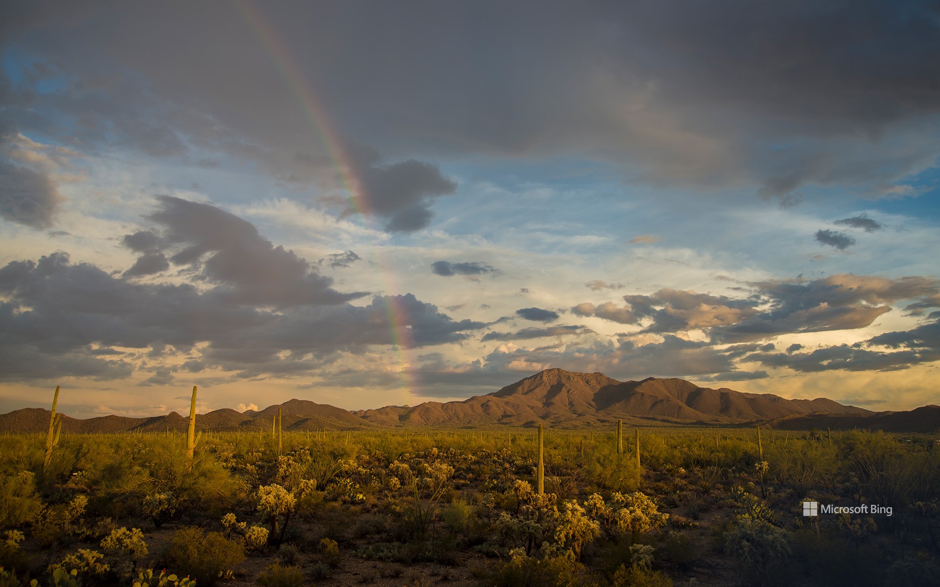
天空无极限 The sky is the limit
沃森峰上空的彩虹, 巨人柱国家公园
您是否曾偶然发现彩虹,并感受到一股幸福感?你是否曾想在雨后捕捉阳光下的七彩奇观?从北欧神话中的众神,到爱尔兰妖精的聚宝盆,彩虹一直被赋予神秘的意义。但除了传说,彩虹背后的科学同样引人入胜,德国物理学家狄奥多里克在1304年给出了第一个合理的解释。他发现,阳光进入雨滴后会发生折射,然后在雨滴内反射,再折射出雨滴。这个过程将光线分解成不同的颜色,形成我们看到的光谱。虽然我们知道 “ROYGBIV”(红、橙、黄、绿、蓝、靛、紫)是彩虹的基本颜色,但彩虹实际上包含了数百万种颜色的渐变混合物。
并非所有彩虹看起来都相同。当第二道较暗且颜色顺序相反的彩虹出现在主彩虹上方时,便形成了双彩虹。今日图片展示了美国亚利桑那州萨瓜罗国家公园瓦森峰上空的一道绚丽彩虹。在干旱少雨的沙漠景观中,仙人掌与岩石山坡构成的背景下,这道彩虹格外醒目,证明了即使在最干燥的土地上,大自然依然能带来惊喜。
National Find a Rainbow Day
Have you ever spotted a rainbow and felt a little lucky? National Find a Rainbow Day, celebrated today, is all about looking to the sky for that magical mix of sun and rain. Nature's color wheel has long been linked to myths and legends, from Norse gods to the Irish leprechaun's pot of gold. But beyond folklore, the science behind rainbows is just as compelling. The first real explanation came from Theodoric of Freiberg, a German physicist, in 1304. He discovered that rainbows form when sunlight enters a raindrop, bends, reflects inside, and then bends again as it exits. This process splits light into its colors, creating the spectrum we see. The classic 'ROYGBIV' (red, orange, yellow, green, blue, indigo, and violet) doesn't tell the whole story—rainbows contain millions of colors blended together.
Not all rainbows look the same. Double rainbows occur when a fainter, reversed arc appears above the main one. Moonbows happen at night when moonlight refracts through water droplets. The rare supernumerary rainbow features extra pastel bands inside the primary arc. Today's image features a rainbow over Wasson Peak in Saguaro National Park, Arizona. Against a backdrop of desert cacti and rocky slopes, the vibrant arc stands out in a place where rain is scarce, proving that even the driest landscapes can surprise you.
凯恩维尔附近荒地的砂岩地层, 犹他州, 美国 Sandstone formations in the badlands near Caineville, Utah (© Chris Moore/TANDEM Stills + Motion)
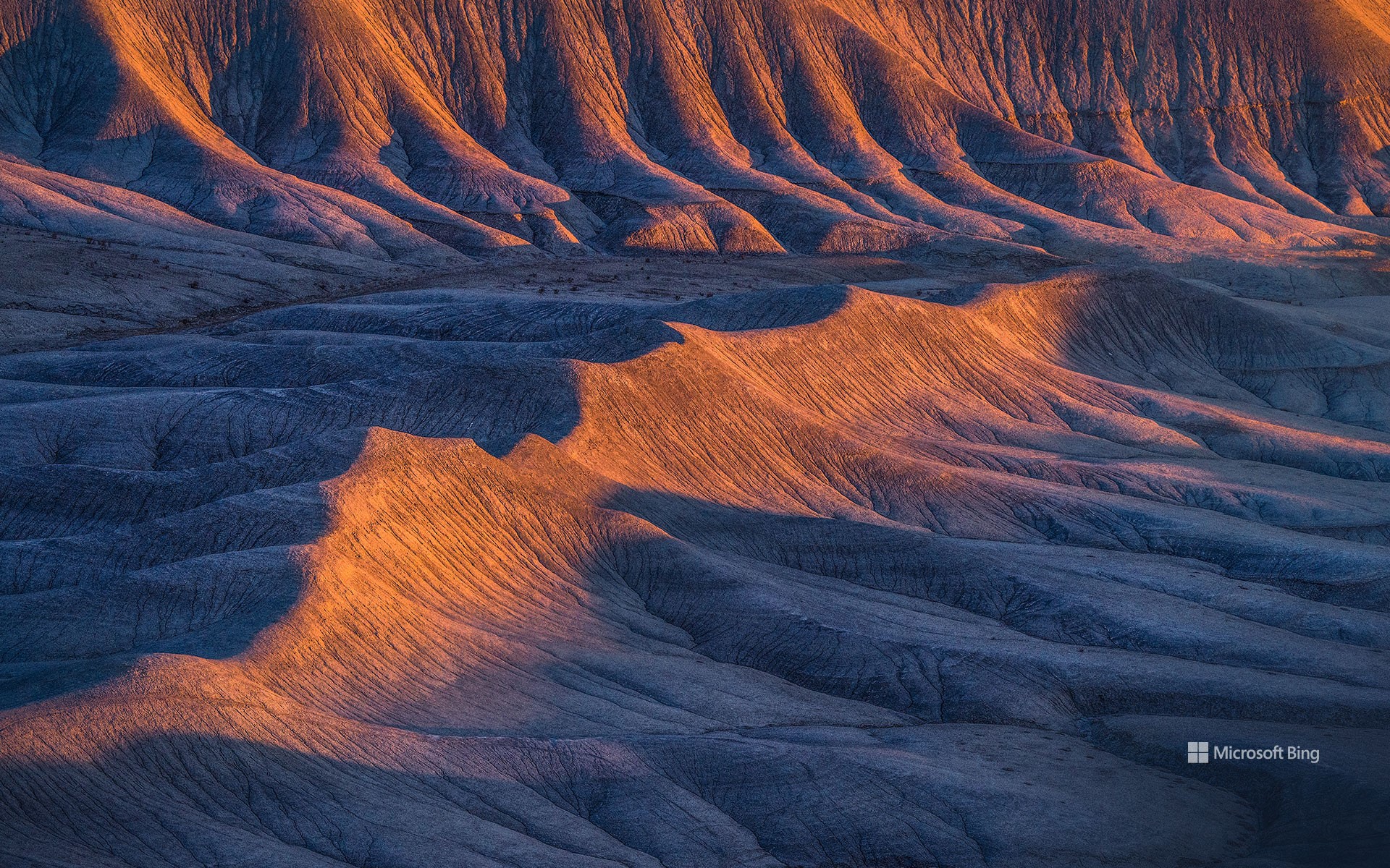
凯恩维尔附近荒地的砂岩地层, 犹他州, 美国 Sandstone formations in the badlands near Caineville, Utah (© Chris Moore/TANDEM Stills + Motion)
时间的波浪 Waves of time
凯恩维尔附近荒地的砂岩地层, 犹他州, 美国
蜿蜒起伏的砂岩脊绵延于犹他州凯恩维尔荒地,宛如大自然在石头上绘制的笔触。这些地貌由细粒沉积物构成,最初沉积在古代河流三角洲和内陆海洋中,随后逐渐硬化为岩石。随着时间的推移,侵蚀作用穿透了这些地层,露出流动般的波纹状图案。沉积岩层记录着气候变迁和古老地貌的演变。今日图片中,这片荒凉的土地看似毫无生机,但在早春时节,降雨会让大地铺满紫色和黄色的小花。一天的不同时刻,光影不断变化,展现出不同的角度与风貌,为摄影师和游客提供了丰富的观赏体验。尽管这片崎岖不平的地形大部分仍然保持原始状态,但部分区域地势较为平缓,允许游客在无需剧烈攀爬的情况下轻松探索。
荒地广布于除南极洲以外的所有大陆。早期探险者在穿越这些艰难地形时遭遇重重困难,因此赋予它们“荒地”之名。古生物学家经常能在这里发现史前生物的化石遗骸。尽管环境极端,这些土地依然孕育着丰富的生命,包括沙漠植物、蜥蜴和鸟类。
Sandstone formations in the badlands near Caineville, Utah
Wavy sandstone ridges stretch across the Caineville Badlands in Utah, resembling nature's brushstrokes on stone. These formations are made of fine-grained sediment that settled in ancient river deltas and inland seas and later hardened into stone. Over time, erosion carved through the layers, exposing flowing, ripple-like patterns. The sedimentary layers tell a story of shifting climates and ancient landscapes. The barren land may appear lifeless, but during early spring, rainfall causes the terrain to be blanketed with tiny purple and yellow flowers. While much of the terrain remains rugged, some areas offer easy access, allowing visitors to explore without strenuous hiking.
Badlands exist on every continent except Antarctica. Early explorers named them after struggling to navigate harsh terrains. Fossil hunters frequently uncover remnants of prehistoric creatures in the eroded hills. Despite the extreme conditions, badlands support a wide range of life, including desert plants, lizards, and birds.
卡里佐平原国家纪念碑的超级花期,加利福尼亚州,美国 Superbloom in Carrizo Plain National Monument, California (© Robb Hirsch/TANDEM Stills + Motion)
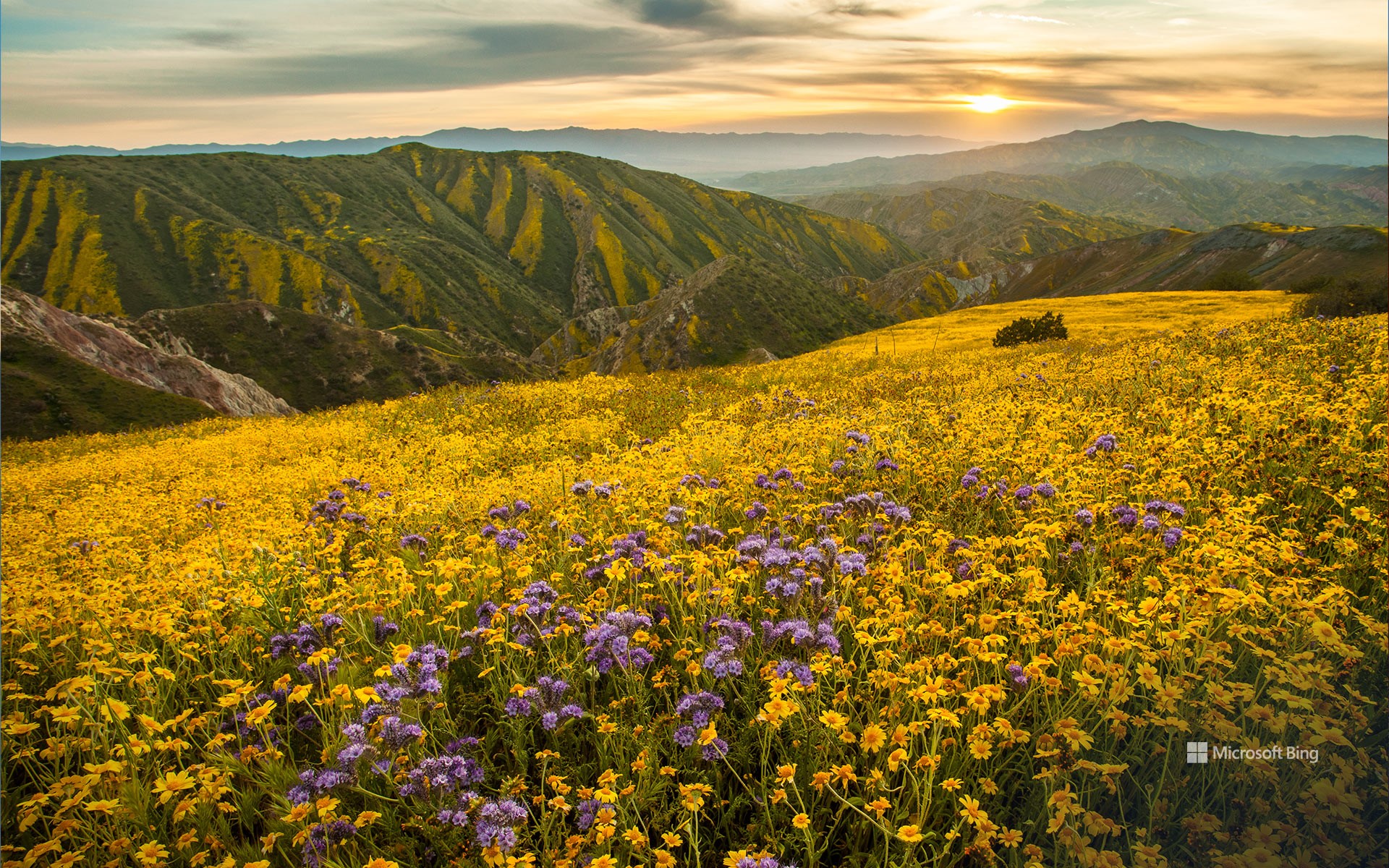
卡里佐平原国家纪念碑的超级花期,加利福尼亚州,美国 Superbloom in Carrizo Plain National Monument, California (© Robb Hirsch/TANDEM Stills + Motion)
花海绽放 Burst of blooms
卡里佐平原国家纪念碑的超级花期,加利福尼亚州
在沙漠地区,大片花朵绽放的景象并不常见,但在超级花海期间,原本干旱的土地将被无尽的花田覆盖。这种罕见的自然现象发生在美国加利福尼亚州和亚利桑那州,当雨季来临,沉睡在土壤中的野花种子被唤醒,形成壮观的花海景观。加利福尼亚州的超级花海通常每十年出现一次,然而21 世纪持续的干旱使其愈发罕见。超级花海不仅展示了加州丰富的植物多样性,还吸引游客前来观赏,短暂地促进当地经济发展。今日图片中的卡里佐平原国家纪念碑正是观赏这一壮观景象的最佳地点之一。这片广阔的封闭型草原位于加利福尼亚州圣路易斯奥比斯波县东南部,全长约50英里,宽约15英里。坦布洛山脉和卡连特山脉的山丘,以及苏打湖附近的谷地,都会变成一片五彩斑斓的野花拼图,绚丽至极。你曾有幸见过超级花海吗?
Superbloom in Carrizo Plain National Monument, California
It's not every day you see a desert burst into colors, but during a superbloom, arid land is covered with endless stretches of flowers. This rare phenomenon happens in California and Arizona when the rainy season awakens wildflower seeds that have been lying dormant in the soil. Superblooms in California typically occur once a decade, but prolonged droughts in the 21st century have made them increasingly less frequent. Drawing attention to California's diverse flora and rural federal lands, these events offer temporary boosts to local economies.
One of the best spots to witness this spectacular phenomenon is Carrizo Plain National Monument, seen in today's image of a superbloom in 2017. A vast enclosed grassland in southeastern San Luis Obispo County, California, this spot is approximately 50 miles long and 15 miles wide. Here, the hills of the Temblor and Caliente Ranges, along with the valley floor near Soda Lake, transform into a patchwork of colorful wildflowers when conditions are right. Have you ever had the chance to see a superbloom?