2021年10月
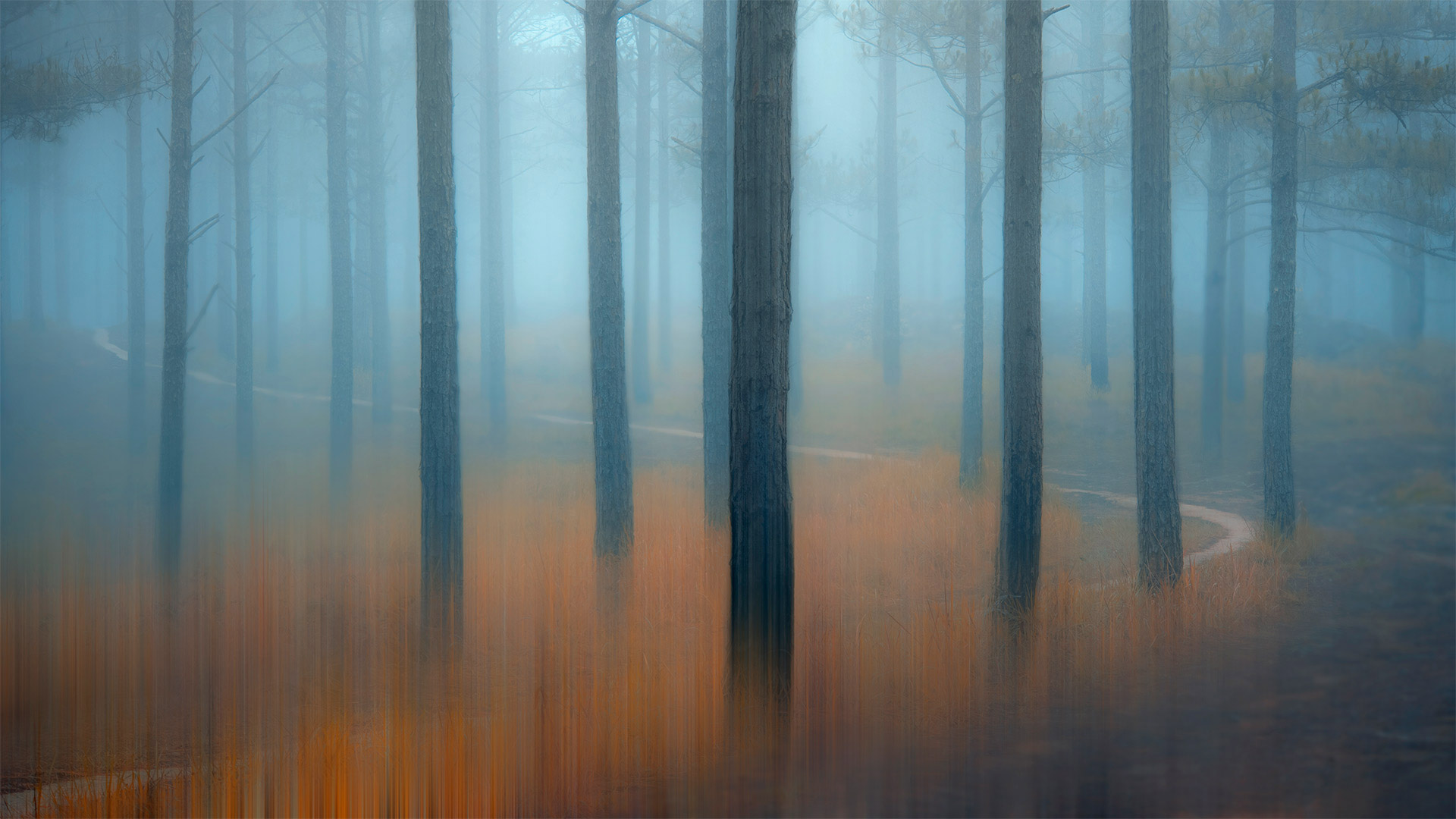
薄雾笼罩的松树林,越南 Misty pine forest in the Central Highlands of Vietnam (© Thanh Thuy/Moment/Getty Images)
薄雾笼罩的松树林,越南 Misty pine forest in the Central Highlands of Vietnam (© Thanh Thuy/Moment/Getty Images)
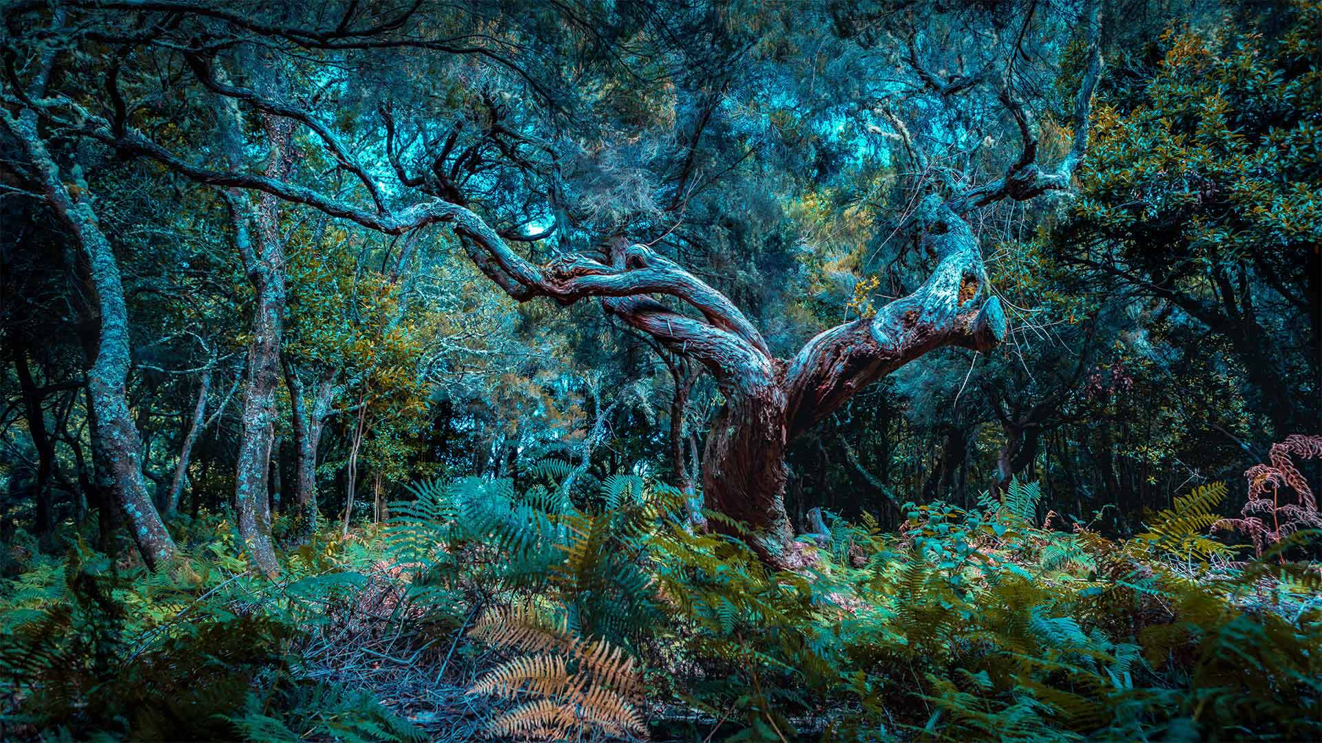
Misty Pine Forest
The woods are a tranquil place, but can be scary for a lone wanderer. Out here, you could suddenly find yourself running from the big bad wolf, escaping a witch's clutches, or just plain old lost. Though often in the old stories, scary places like this are also where the hero overcomes a great obstacle or finds a valuable treasure. Could you be in luck?
The spindly pine forests of the Central Highlands of Vietnam, shown here, are the setting for many traditional tales of evil spirits and spells. But even if you don't believe in all that magic stuff, a forest can still feel enchanted when twilight bathes the misty air. Just don't lose your way out here…
雾松林
森林是一个宁静的地方,但对一个孤独的流浪者来说却很可怕。在这里,你可能会突然发现自己在逃离大灰狼,逃离女巫的魔爪,或者只是普通的迷失。虽然在古老的故事中经常出现,但像这样可怕的地方也是英雄克服巨大障碍或找到宝贵财富的地方。你运气好吗?
如图所示,越南中部高地细长的松林是许多传统邪灵和咒语故事的背景。但即使你不相信所有这些神奇的东西,当暮色沐浴在朦胧的空气中时,森林仍然会感到被施了魔法。只是别在这里迷路…
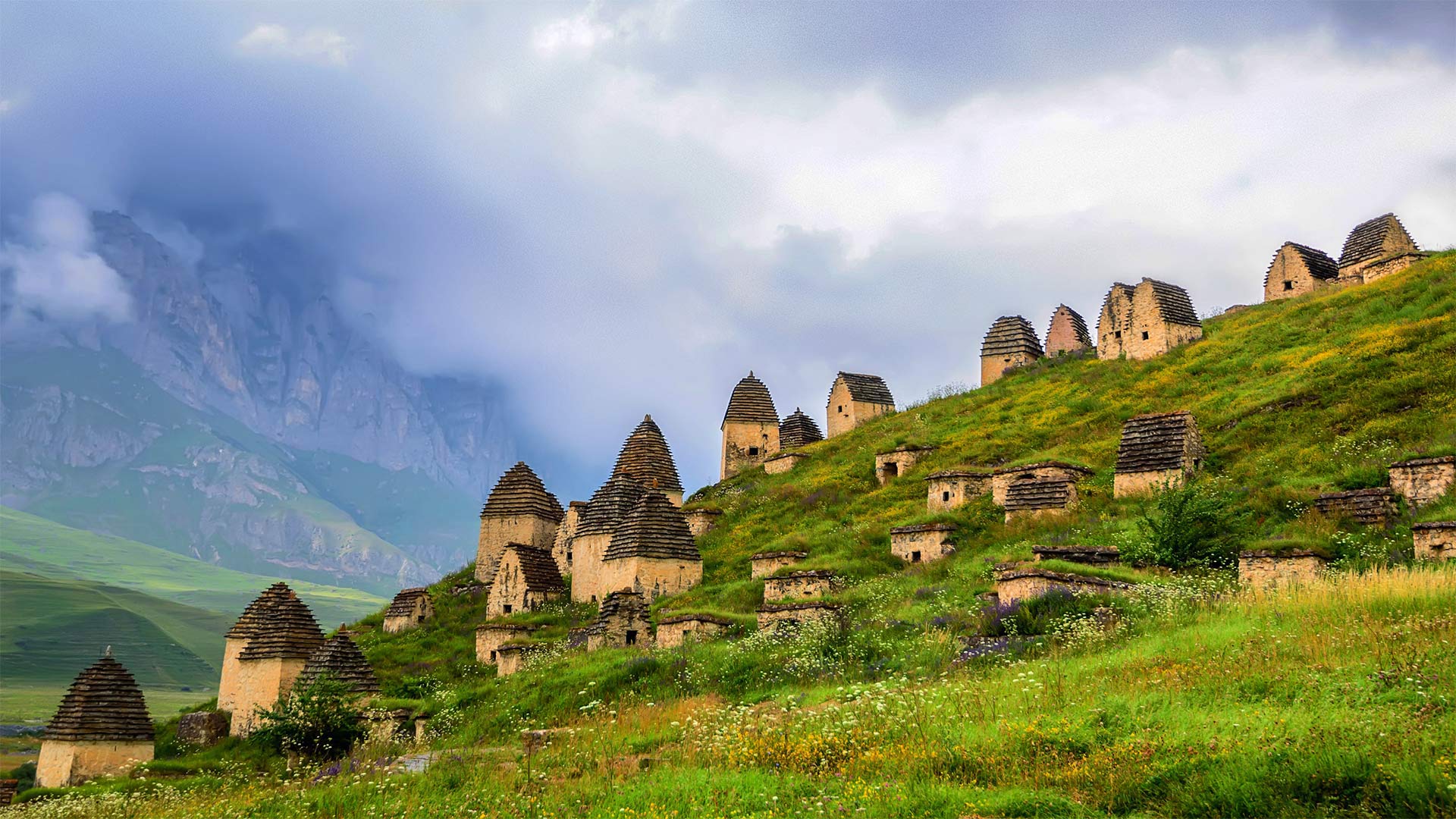
北奥塞梯-阿兰共和国的一片墓地,俄罗斯 Necropolis near Dargavs, North Ossetia, Russia (© Yakov Oskanov/Shutterstock)
北奥塞梯-阿兰共和国的一片墓地,俄罗斯 Necropolis near Dargavs, North Ossetia, Russia (© Yakov Oskanov/Shutterstock)
Necropolis Near Dargavs
Be glad we're merely paying a virtual visit to this 'City of the Dead' outside Dargavs, Russia. Local folklore warns that if you set foot here, you won't escape with your life. We're not sure the dead pose such a mortal danger, but what's certain is that this is a dead-quiet village. These vaulted-roof huts are not homes—they're crypts.
Were you here, you might peer into the sole window of any of these huts and see the inhabitants, some entombed with their earthly possessions, others laid to rest in rowboats to paddle into the afterlife. Many of the remains are preserved unsettlingly well—and they more than outnumber you. In use from at least the 16th to 18th centuries, this necropolis is populated by about 10,000 departed ancestors.
Spooked enough yet? If not, try today's quiz about cemeteries, tombstones, and other grave matters…if you dare.
达尔加夫附近的墓地
很高兴我们只是虚拟地参观了俄罗斯达尔加夫郊外的这座“死亡之城”。当地民间传说警告说,如果你踏上这里,你将无法逃命。我们不确定死者是否会构成致命的危险,但可以肯定的是,这是一个死寂的村庄。这些拱形屋顶小屋不是家,而是地窖。
如果你在这里,你可能会从这些小屋的唯一窗户望出去,看到里面的居民,有些人被埋在地上,有些人躺在划艇上,准备划入来世。许多遗骸保存得令人不安,数量超过你。至少从16世纪到18世纪,这个墓地居住着大约10000名逝去的祖先。
够吓人了吗?如果不是的话,试试今天关于墓地、墓碑和其他坟墓的小测验……如果你敢的话。
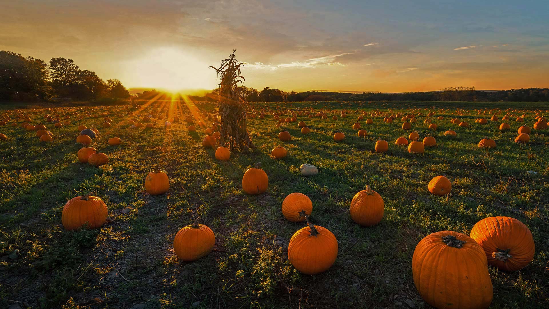
牛顿市的一片南瓜地,美国马萨诸塞州 A pumpkin patch in Newton, Massachusetts (© Frank Debonis/EyeEm/Alamy)
牛顿市的一片南瓜地,美国马萨诸塞州 A pumpkin patch in Newton, Massachusetts (© Frank Debonis/EyeEm/Alamy)
Pumpkin
It's not too late to pick up a pumpkin to add some Halloween flair to your doorstep. Although pumpkins are grown across the country, most of the 2 billion pounds produced in the US come from five states: California, Illinois, Indiana, Pennsylvania, and Texas. While California grows the most pumpkins headed for the jack-o'-lantern market, Illinois wins in poundage, though, most of its crop ends up as pie filling or other processed products—perhaps even your pumpkin spice latte?
And while we're talking orange orbs, what is a pumpkin exactly? You might think they're vegetables, but botanists say they're the fruit of pumpkin vines. They're considered fruit because pumpkins contain seeds and grow from the same part of the plant that produces flowers. Whether you opt to consume or carve, we invite you to enjoy this fruit of the spookiest season!
南瓜
现在还来得及拿起一个南瓜来给你的门阶增添万圣节的气息。尽管南瓜在全国各地都有种植,但美国生产的20亿磅南瓜中的大部分来自五个州:加利福尼亚州、伊利诺伊州、印第安纳州、宾夕法尼亚州和得克萨斯州。虽然加利福尼亚州种植的南瓜最多,销往南瓜灯市场,但伊利诺伊州的南瓜收成却以手续费取胜,尽管如此,它的大部分南瓜收成都是馅饼馅料或其他加工产品,甚至是你的南瓜香料拿铁?
当我们谈论橙色球体时,南瓜到底是什么?你可能认为它们是蔬菜,但植物学家说它们是南瓜藤的果实。南瓜之所以被认为是水果,是因为南瓜含有种子,并且是从植物的同一部位生长而成的。无论您选择消费还是雕刻,我们都邀请您享受这个最恐怖季节的水果!
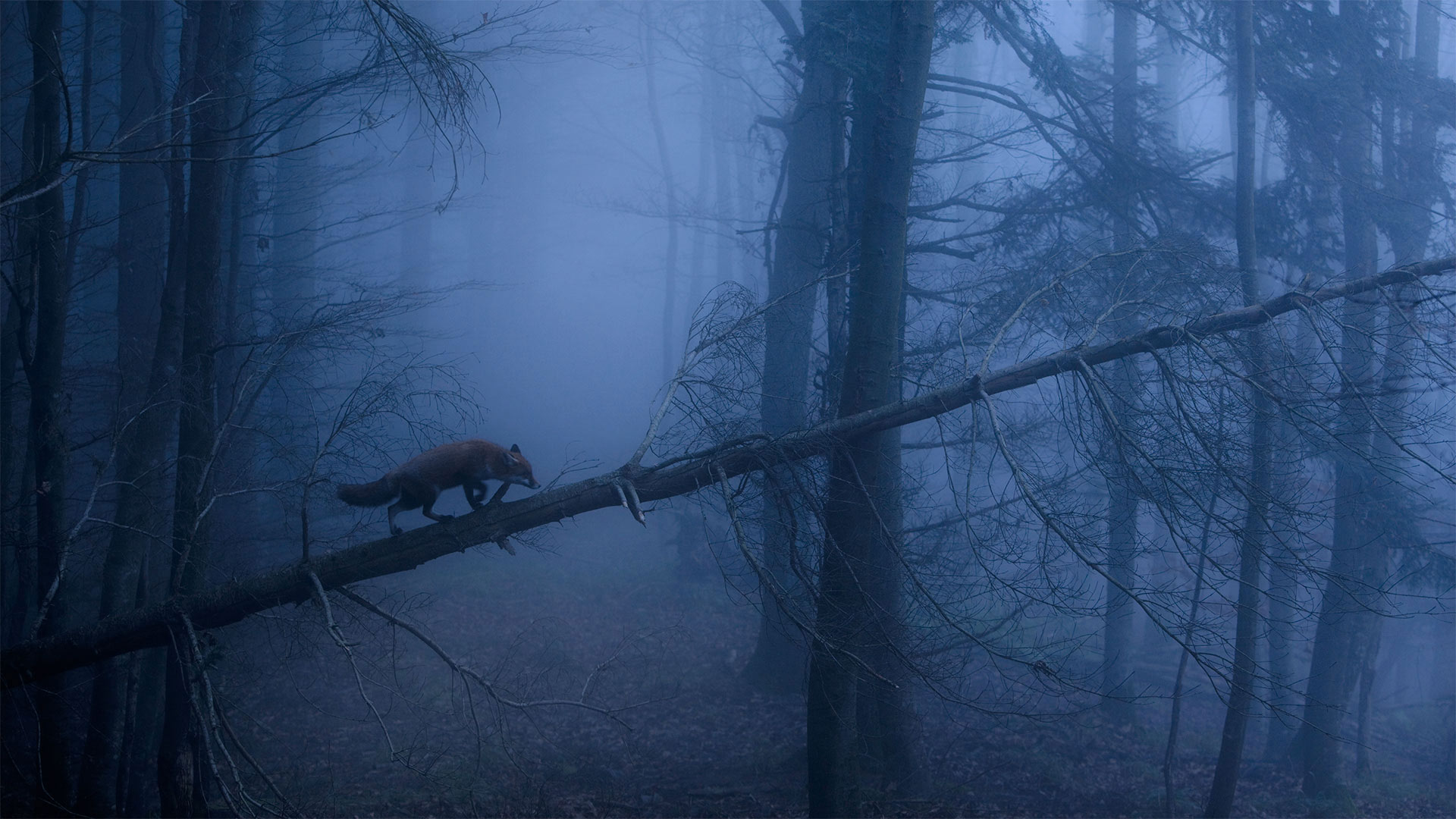
黑林山中的赤狐,德国 Red fox in the Black Forest of Germany (© Klaus Echle/Minden Pictures)
黑林山中的赤狐,德国 Red fox in the Black Forest of Germany (© Klaus Echle/Minden Pictures)
A red fox stalks the Black Forest
Even in the most flattering daylight, foxes somehow always seem up to no good. Not to mention when they're spotted slinking up a fallen tree in a dank, shadowy Black Forest in Germany. These cunning canids get away with a lot just by being cute, don't you think?
That mischievous twinkle in a fox's eye hasn't gone unnoticed by countless cultures around the world. Most fox myths venerate the critter as a trickster or even a shapeshifter who outfoxes larger, meaner foes like lions and bears. But the fox is said to sometimes hoodwink humans too…so keep your wits about you while wandering the wilderness.
一只红狐在黑森林里游荡
即使在最讨人喜欢的日子里,狐狸也似乎总是做得不好。更不用说他们在德国潮湿阴暗的黑森林里偷偷爬上一棵倒下的树了。这些狡猾的犬科动物仅仅因为可爱就逃脱了很多惩罚,你不这么认为吗?
这种恶作剧般的眨眼行为并没有被全世界无数文化所忽视。大多数关于狐狸的神话都把这种小动物视为一个骗子,甚至是一个变形者,它能击败更大、更卑鄙的敌人,如狮子和熊。但是据说狐狸有时也会欺骗人类……所以在荒野中游荡时,要保持机智。
阿尔达河上的魔鬼桥,保加利亚 Dyavolski Most (Devil's Bridge) over the Arda River in Bulgaria (© Petar Mladenov/Alamy)

阿尔达河上的魔鬼桥,保加利亚 Dyavolski Most (Devil's Bridge) over the Arda River in Bulgaria (© Petar Mladenov/Alamy)
Does this crossing carry a curse?
You've heard of a bridge over troubled waters, but what if the bridge is troubled too? Legend tells of a Bulgarian stonemason, Dimitar, who was tasked with solving a bridge problem here in the early 1500s. Dimitar was hired to construct a crossing that wouldn't collapse into the rushing Arda river, as had all previous spans in this strange spot.
How could Dimitar build a bridge to beat all the others? By making a deal with the devil, of course. As one version of the story goes, Lucifer impelled Dimitar to encase his wife's shadow in the stonework, which imbued the bridge with supernatural strength against the rapids. The diabolical catch? Trapping her shadow meant she was doomed to death once construction was completed. Dimitar finished the bridge in 40 days, and his wife died shortly after.
Dyavolski Most (Devil's Bridge) in the Rhodope Mountains of southern Bulgaria stands tall to this day as proof of Dimitar's deadly pact. Or could it be, perhaps, that Dimitar was just a really good stonemason? Five centuries on, it's all water under the bridge…
这个十字路口有诅咒吗?
你听说过一座跨越麻烦的桥,但如果这座桥也有麻烦呢?传说中有一位名叫迪米塔尔的保加利亚石匠,在16世纪初被派来解决这里的一座桥梁问题。迪米塔尔被雇来建造一条不会倒塌到湍急的阿尔达河中的渡口,就像在这个陌生的地方以前所有的跨度一样。
迪米特尔怎么能建造一座桥梁来击败其他所有人?当然是和魔鬼做交易。正如故事的一个版本所说,路西法迫使迪米特尔将他妻子的影子包裹在石雕中,石雕使桥充满了抵御急流的超自然力量。恶魔般的捕获?困在她的影子里意味着一旦建筑完工,她就注定要死。迪米特尔在40天内完成了这座桥,他的妻子不久就去世了。
位于保加利亚南部罗多普山脉的迪亚沃斯基Most(魔鬼之桥)屹立至今,是迪米塔尔致命契约的证明。或者,也许迪米特尔只是一个真正优秀的石匠?五个世纪过去了,桥下全是水…
像巨大指纹一样的Bavljenac岛,克罗地亚 Bavljenac Island, Croatia (© Julien Duval/Amazing Aerial Agency)
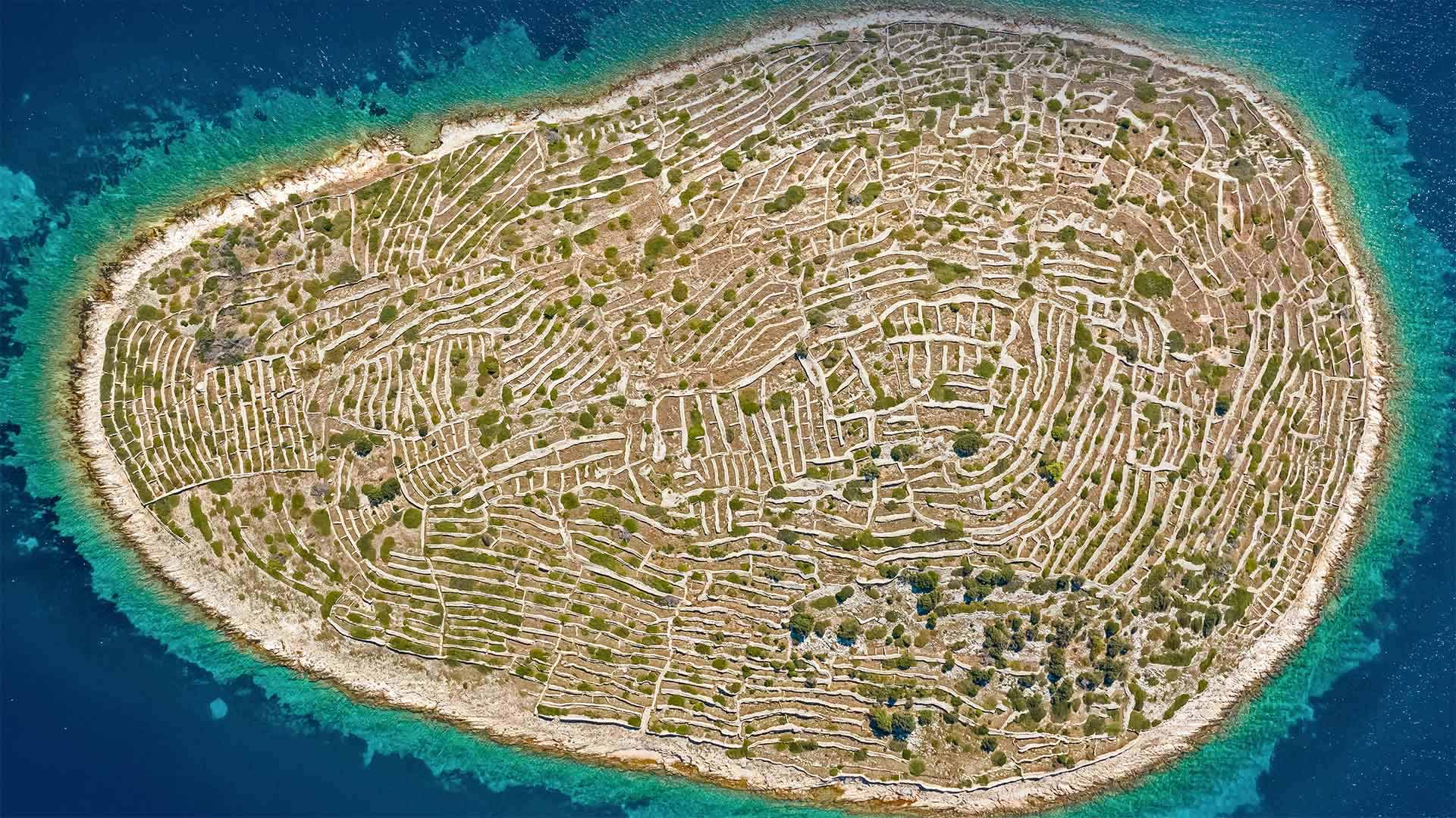
像巨大指纹一样的Bavljenac岛,克罗地亚 Bavljenac Island, Croatia (© Julien Duval/Amazing Aerial Agency)
This 'fingerprint' is one of a kind
Of the 1,246 islands on Croatia's fragmented coast, the unique isle of Bavljenac might be the most identifiable. It's nicknamed 'Fingerprint Island' for its miles of dry-stone walls that look like the whorled ridges of a human fingerprint. The tiny, uninhabited landmass in the Adriatic Sea was once an agricultural center. In the 19th century—the heyday of Croatian wine production— farmers from the nearest populated island built the winding walls on Bavljenac to protect olive trees and grapevines from the winds blowing in from the Adriatic.
这种“指纹”是独一无二的
在克罗地亚支离破碎海岸上的1246个岛屿中,独一无二的巴夫勒耶纳克岛可能是最容易辨认的。它的绰号是“指纹岛”,因为它有几英里长的干石墙,看起来像是人类指纹的螺纹纹路。亚得里亚海中无人居住的小块陆地曾经是一个农业中心。19世纪是克罗地亚葡萄酒生产的全盛时期,来自最近人口稠密岛屿的农民在巴夫勒耶纳克修建了蜿蜒的城墙,以保护橄榄树和葡萄藤免受亚得里亚海吹来的风的影响。
划过湖面上空的新智彗星,加拿大贾斯珀国家公园 (© Stocktrek Images, Inc./Alamy)

阿查法拉亚盆地的秃柏和西班牙苔藓,路易斯安那州 Bald cypress and Spanish moss in the Atchafalaya Basin, Louisiana (© Chris Moore/Exploring Light Photography/Tandem Stills + Motion)

阿查法拉亚盆地的秃柏和西班牙苔藓,路易斯安那州 Bald cypress and Spanish moss in the Atchafalaya Basin, Louisiana (© Chris Moore/Exploring Light Photography/Tandem Stills + Motion)
Here's looking Atchafalaya
Encompassing 14 Louisiana parishes and over 1.4 million acres, the Atchafalaya Basin is one of the United States' 55 National Heritage Areas, the one they call America's Foreign Country. Bayous, marshes, backwater lakes, and the nation's largest river swamp make up one of the most diverse ecological and cultural landscapes in North America.
The Choctaw people named the area 'long river' or 'hacha falaia.' Over the past four centuries, waves of French, Spanish, African, Acadian, and Caribbean settlers have contributed to the unique Cajun language, cuisine, music, architecture, and storytelling traditions that set this region apart.
The bald cypress trees—seen here draped in Spanish moss—are an iconic part of this incredibly rich ecosystem. Wildlife here includes crawfish, catfish, shrimp, bears, alligators, and over 270 species of birds. The Atchafalaya Basin was recognized as a National Heritage Area (NHA) in 2006. Unlike National Parks, NHAs function as a partnership between residents, local, and federal agencies, that combine private and public lands into more livable and sustainable regions.
这是阿查法拉亚
阿查法拉亚盆地包括路易斯安那州14个教区和140多万英亩土地,是美国55个国家遗产区之一,他们称之为美国的外国。贝尤斯、沼泽、回水湖和美国最大的河流沼泽构成了北美最多样化的生态和文化景观之一。
乔克托人将该地区命名为“长河”或“hacha falaia”。在过去的四个世纪里,法国、西班牙、非洲、阿卡迪亚和加勒比海的移民潮为该地区独特的卡琼语、烹饪、音乐、建筑和讲故事传统做出了贡献,使该地区与众不同。
这里的秃顶柏树覆盖着西班牙苔藓,是这个极其丰富的生态系统的标志性部分。这里的野生动物包括小龙虾、鲶鱼、虾、熊、短吻鳄和270多种鸟类。阿查法拉亚盆地于2006年被确认为国家遗产区(NHA)。与国家公园不同,国家公路局是居民、地方和联邦机构之间的伙伴关系,将私人和公共土地结合成更宜居和可持续的区域。
马德拉岛的法纳尔森林,葡萄牙 The Fanal Forest on Madeira Island, Portugal (© Val Thoermer/Alamy)
马德拉岛的法纳尔森林,葡萄牙 The Fanal Forest on Madeira Island, Portugal (© Val Thoermer/Alamy)
These laurels are hardy
Go back 15 million years and you'll find most of Southern Europe looking like this fantasy forest: thick, scrubby underbrush canopied by wizened laurel trees. An epoch or two of human agricultural advances cleared those ancient woods, but patches persist on a few temperate Atlantic islands—Especially here on Madeira, a Portuguese-held island off northwest Africa.
The Fanal Forest, at almost 60 square miles, is the largest surviving laurel forest in the world. Ninety percent of the forest's growth remains uncut, and some of these long-in-the-root laurels have stood for 500 years.
这些桂冠很耐寒
追溯到1500万年前,你会发现欧洲南部的大部分地区都像是一片梦幻森林:茂密的灌木丛中覆盖着干枯的月桂树。人类农业的进步使这些古老的森林消失了一两个世纪,但在一些温带大西洋岛屿上,特别是在非洲西北部葡萄牙控制的马德拉岛上,仍然存在着一些斑块。
法纳尔森林面积近60平方英里,是世界上现存最大的月桂林。森林生长的百分之九十没有被砍伐,其中一些长根月桂已经存在了500年。
史诺多尼亚国家公园的Capel Curig,英国威尔士 Capel Curig in Snowdonia National Park, Wales, United Kingdom (© Sebastian Wasek/Sime/eStock Photo)
史诺多尼亚国家公园的Capel Curig,英国威尔士 Capel Curig in Snowdonia National Park, Wales, United Kingdom (© Sebastian Wasek/Sime/eStock Photo)
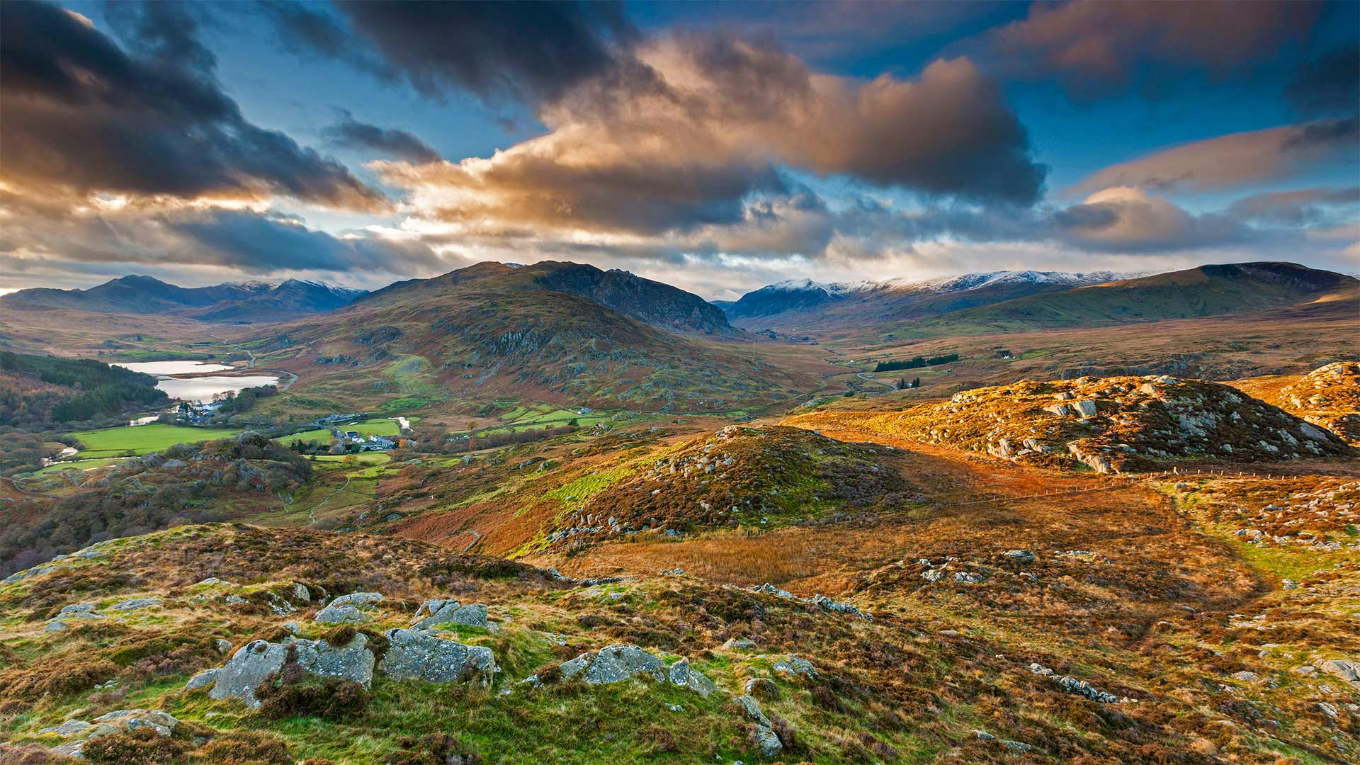
A Welsh wonder turns 70
Here on the west coast of Great Britain, we're enjoying views of the windswept uplands and jagged peaks that surround the small village of Capel Curig in the heart of Snowdonia National Park. Renowned for its rugged and mountainous landscape, Snowdonia is the largest national park in Wales and home to over 26,000 people—and even more sheep—the wooly farm animals outnumber people three to one in Wales. About 60% of the park's population speak Welsh, one of Europe's oldest languages, and today they will be wishing this spectacular setting a 'pen-blwydd hapus' (happy birthday) as Snowdonia celebrates its 70th anniversary.
Established on October 18, 1951 as the first national park in Wales, Snowdonia boasts nine mountain ranges that cover just over half the park's 823 square miles. Its most popular peak is Snowdon (Yr Wyddfa in the local Welsh tongue), the tallest mountain in Wales and England, which you can see in the background of our photo. At 3,560 feet, Snowdon is one of 15 mountains within the park that top 3,000 feet, and they're clustered close enough together to make it possible to reach all 15 summits within 24 hours, a challenge known as the Welsh 3000s.
威尔士奇迹70岁
在英国西海岸,我们可以欣赏到斯诺多尼亚国家公园中心的卡佩尔·库里小村庄周围被风吹过的高地和参差不齐的山峰。斯诺登尼亚以其崎岖多山的景观而闻名,是威尔士最大的国家公园,居住着26000多人,甚至更多的绵羊。在威尔士,羊毛农场动物的数量比人多三倍。大约60%的公园人口讲威尔士语,威尔士语是欧洲最古老的语言之一。今天,在斯诺多尼亚庆祝其70周年之际,他们将祝愿这一壮观的场景成为“彭·布吕德·哈布斯”(生日快乐)。
斯诺登尼亚于1951年10月18日建立,是威尔士的第一个国家公园,拥有九座山脉,占地823平方英里,略超过公园面积的一半。它最受欢迎的山峰是斯诺登(当地威尔士语中的Yr Wyddfa),这是威尔士和英格兰最高的山峰,你可以在我们的照片背景中看到。斯诺登海拔3560英尺,是公园内海拔3000英尺的15座山峰之一,它们聚集在一起,足以在24小时内到达所有15座山峰,这一挑战被称为威尔士3000山脉。