标签 越南 下的文章
归春河上的板约-德天瀑布,中国与越南边境 Bản Giốc–Detian Falls on the Quây Sơn River, Vietnam (© Shane P. White/Minden Pictures)
归春河上的板约-德天瀑布,中国与越南边境 Bản Giốc–Detian Falls on the Quây Sơn River, Vietnam (© Shane P. White/Minden Pictures)
边境天堂 A borderline paradise
板约-德天瀑布,中国与越南边境
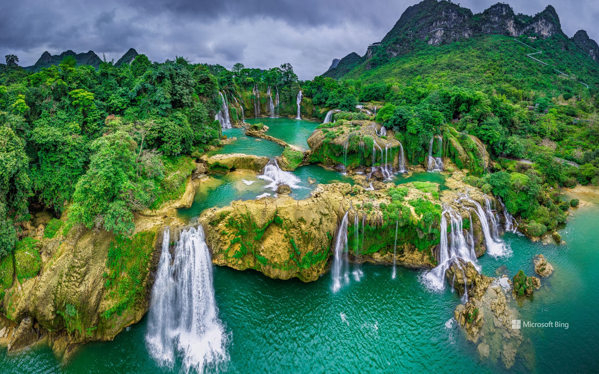
欢迎来到河流与边界线交汇的绝美之地:板约-德天瀑布。今日图片展示的正是这幅美景。该瀑布位于中国广西壮族自治区大新县与越南高平省重庆县之间的喀斯特地貌山丘区,沿着归春河流下。瀑布高达95英尺,宽980英尺,是越南最宽的瀑布,距离河内169英里。多年来,板约瀑布的顶端因侵蚀而缓慢向上游延伸。一年中的大部分时间里,它们以两个独立的瀑布流淌,但到了夏季,当雨水使河水上涨时,它们会汇合成一个巨大的瀑布。
尽管道路得以改善,公共交通更加便利,无人机视频也展示了瀑布的壮丽美景,但板约瀑布依然保留着原始与静谧的一面。大规模旅游尚未波及这里,因此在大多数工作日,您只会遇到寥寥无几的游客、当地居民,以及瀑布奔涌的声音。
Bản Giốc–Detian Falls, Vietnam
Welcome to a spot where rivers meet international borders in the most stunning way: the Bản Giốc – Detian Falls, featured in today's image. Tucked between the karst hills of China's Daxin County and Trùng Khánh district in Vietnam, these falls tumble along the Quây Sơn River about 170 miles north of Hanoi. For most of the year, they flow as two distinct cascades, but come summer, when the rains swell the river, they merge into one big fall. At over 95 feet tall and 980 feet wide, Bản Giốc holds the distinction of being the widest waterfall in Vietnam.
Even with better roads, easier public transport, and drone videos showing off the jaw-dropping beauty of the falls, Bản Giốc remains refreshingly off the beaten path. Mass tourism hasn't caught up yet, and on most weekdays, you'll find only a handful of visitors—just you, the locals, and the sound of cascading water.
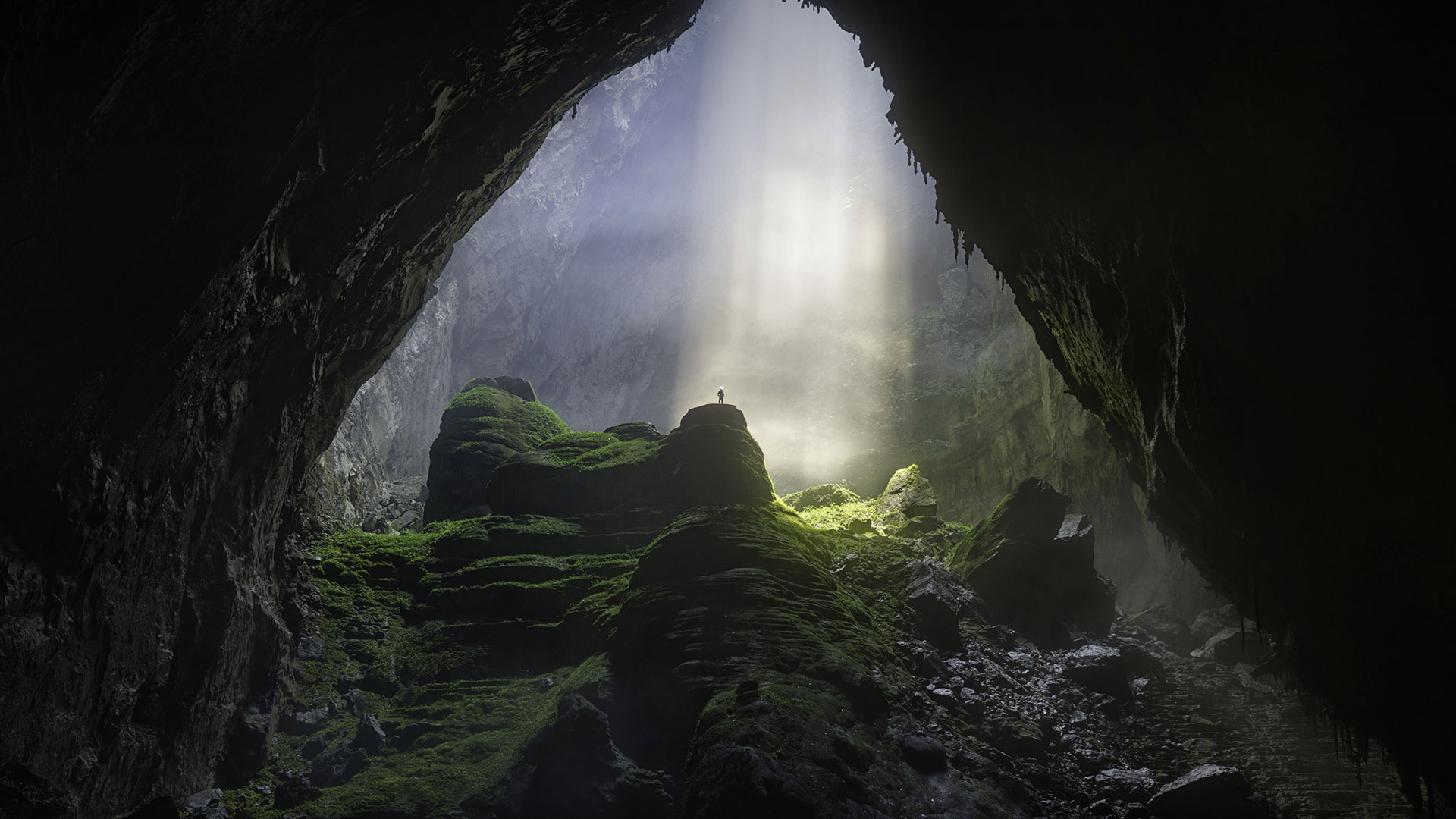
韩松洞,风牙者榜国家公园,越南 Hang Sơn Đoòng cave, Phong Nha-Kẻ Bàng National Park, Vietnam (© Geng Xu/Getty Images)
韩松洞,风牙者榜国家公园,越南 Hang Sơn Đoòng cave, Phong Nha-Kẻ Bàng National Park, Vietnam (© Geng Xu/Getty Images)
“洞”之新世界 A 'hole' new world
韩松洞,风牙者榜国家公园,越南
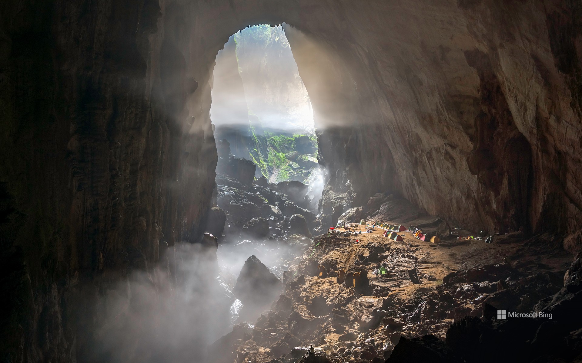
1991年,一名越南伐木工人在越南的风牙者榜国家公园偶然发现了一个大东西。在丛林探险时,他发现了一个洞穴的入口,里面有着咆哮的地下河,后来被命名为韩松洞,即“山水洞”。2009年,英国洞穴研究协会率领一支探险队对该遗址进行了勘探。就在那时,他们发现了一件不可思议的事:这是世界上最大的洞穴!你要问有多大?韩松洞的主要通道长3.1英里,宽490英尺,高660英尺。它的高度足以容纳一座40层的摩天大楼!里面有一个200英尺高的方解石屏障,被称为“越南长城”,石笋高达260英尺。它甚至有自己的天气系统;由于洞穴空气和外部空气之间的温差,洞内形成了云层。此外,一条地下河流将韩松洞与附近的洞穴连接起来,暗示着还有尚未被发现的深度。鉴于其脆弱的生态系统,为保护韩松洞的原始状态制定了严格的规定。每年参观洞穴的游客数量限制在1000人以内。
Hang Sơn Đoòng Cave, Vietnam
In 1991, logger Hồ Khanh stumbled upon something big in what is now Vietnam's Phong Nha-Kẻ Bàng National Park. During a jungle expedition, he found the entrance to a cave with a roaring underground river. It was later named Hang Sơn Đoòng (cave of the mountain river) and in 2009, the British Cave Research Association led an expedition to explore it. They realized something incredible: It was the world's largest cave. Hang Sơn Đoòng's main passage is 3.1 miles long, 490 feet wide, and 660 feet high. That's tall enough to fit a 40-story skyscraper.
Inside the cave, there is a 200-foot calcite barrier called the 'Great Wall of Vietnam' and stalagmites stretching as tall as 260 feet. It even has its own weather system; clouds form inside due to temperature differences between the cave air and the outside air. Moreover, an underground river links Hang Sơn Đoòng to the nearby Hang Thung cave, suggesting undiscovered depths. Given its fragile ecosystem, strict regulations are in place to preserve Hang Sơn Đoòng's pristine condition. Tours of the cave are limited to 1,000 visitors per year.
越南安沛省木仓寨的水稻梯田 Rice terraces of Mù Cang Chải, Yên Bái province, Vietnam (© Kiatanan Sugsompian/Getty Images)
越南安沛省木仓寨的水稻梯田 Rice terraces of Mù Cang Chải, Yên Bái province, Vietnam (© Kiatanan Sugsompian/Getty Images)
阳光下的梯田 Rice and shine
越南安沛省木仓寨的水稻梯田
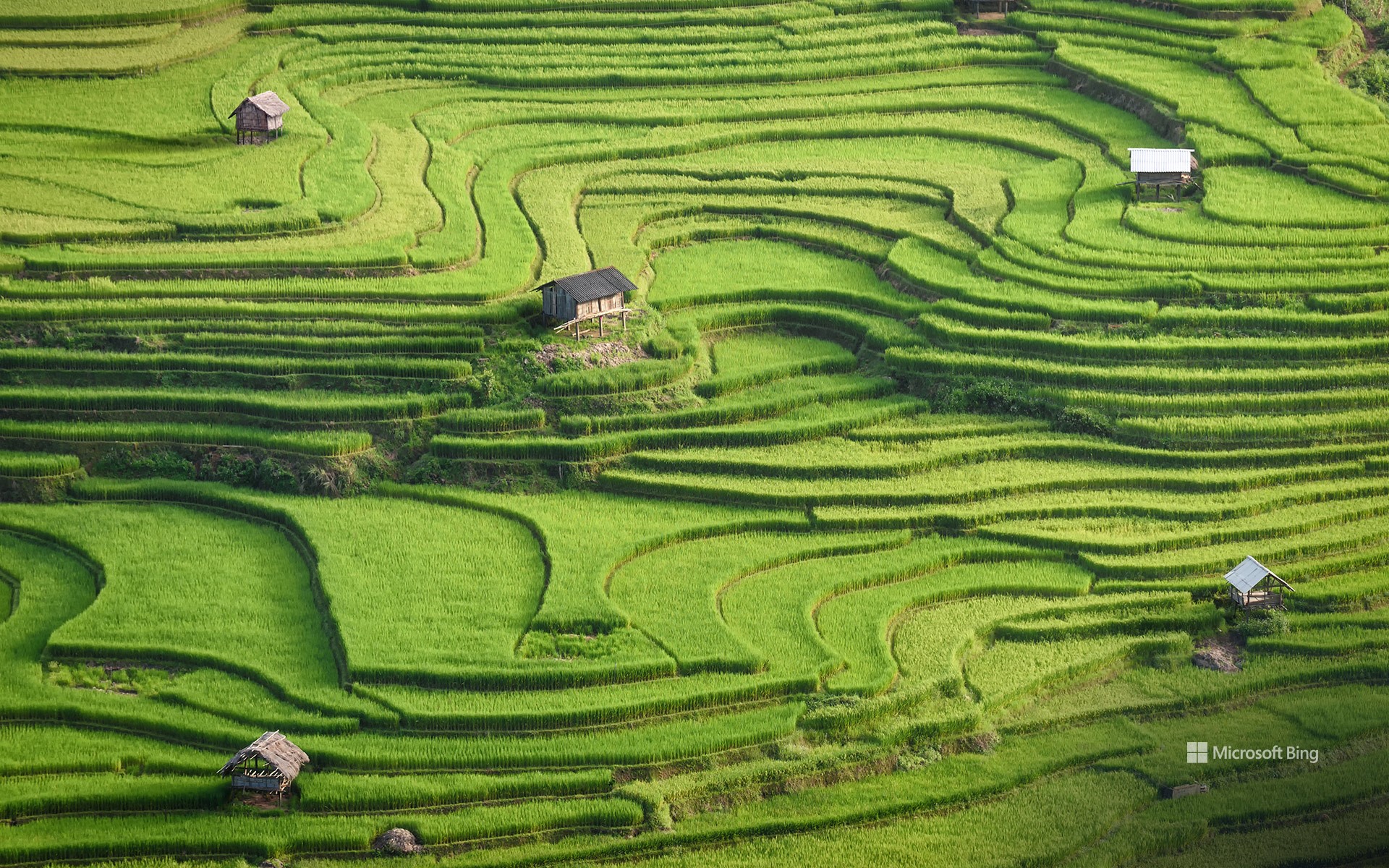
在越南安沛省连绵起伏的群山之中,木仓寨地区的水稻梯田是农耕文化的精华所在。苗族是一个以其丰富的文化和充满活力的服装而闻名的少数民族,世世代代精心雕刻着这些层叠的山丘。19世纪,苗族从中国迁徙到越南北部。他们擅长轮作(一种农业系统),在这种农业系统中,土地被暂时耕种,种植的作物包括小米、水稻、玉米和大麦,随后再恢复其自然植被。
木仓寨拥有约5,500英亩的梯田。正值收获季节,游客还可以在当地市场品尝越南美食和购买丰富多彩的纪念品,或登上罗盘秦村的山顶欣赏该地区迷人的地形地貌。
Rice terraces of Mù Cang Chải, Yên Bái province, Vietnam
Amid the rolling hills of northern Vietnam's Yên Bái province, the rice terraces of Mù Cang Chải district are a mosaic of agricultural excellence. The Hmong people, an ethnic minority who migrated here from China in the 19th century, have meticulously carved these cascading hills for generations. Mù Cang Chải boasts approximately 5,500 acres of terraced rice fields, which flood with water between September and October, reflecting the surrounding mountains and sky. Visitors can also indulge in Vietnamese dishes and colorful souvenirs at the local markets or climb to the peak of La Pan Tan village to enjoy views of this stunning landscape.
海水从古老的珊瑚礁上倾泻而下,杭莱,越南 Seawater cascades over an ancient coral reef, Hang Rai, Vietnam (© Thang Tat Nguyen/Getty Images)
海水从古老的珊瑚礁上倾泻而下,杭莱,越南 Seawater cascades over an ancient coral reef, Hang Rai, Vietnam (© Thang Tat Nguyen/Getty Images)
潮汐探戈 A tidal tango
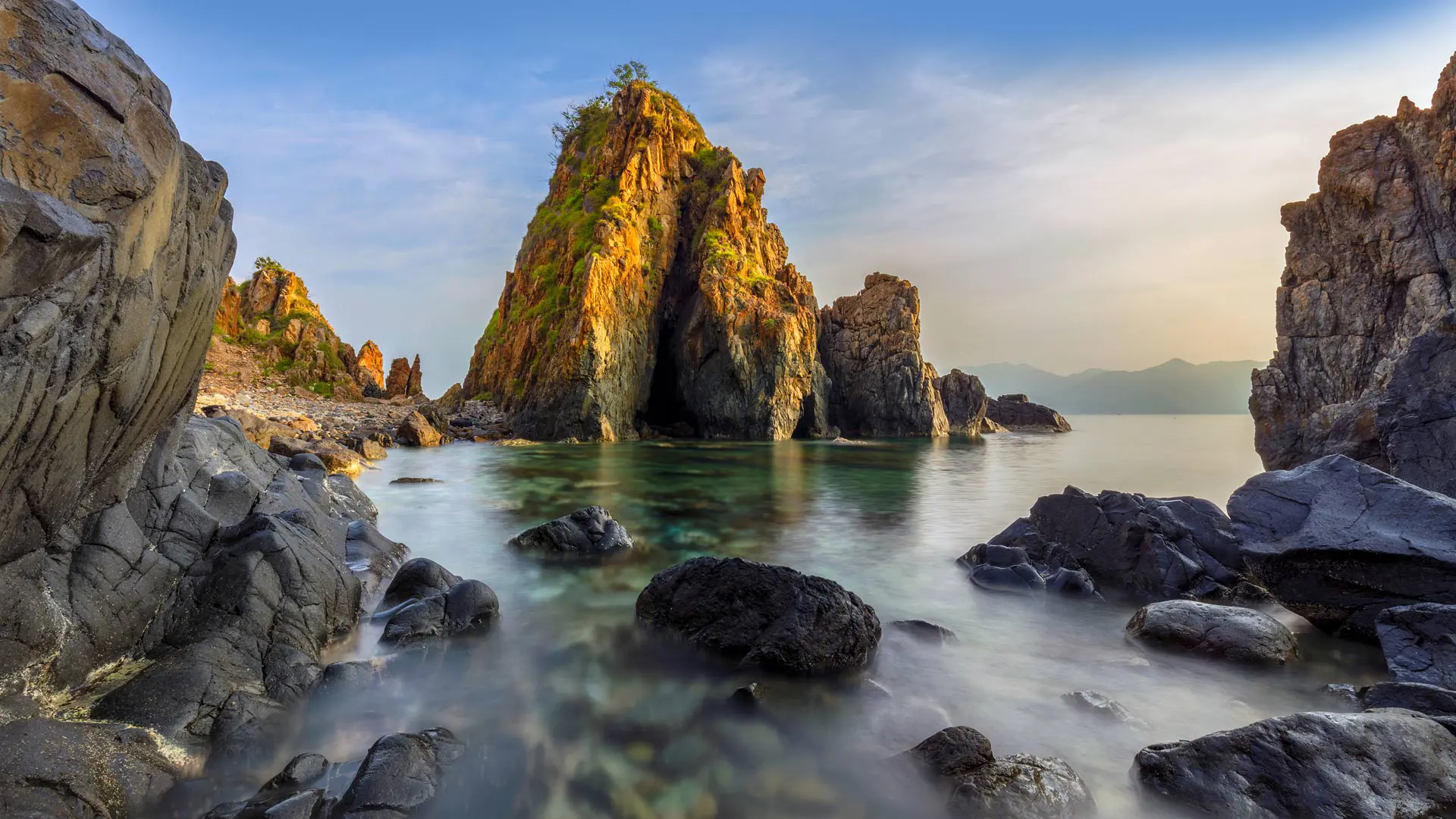
永希湾,越南
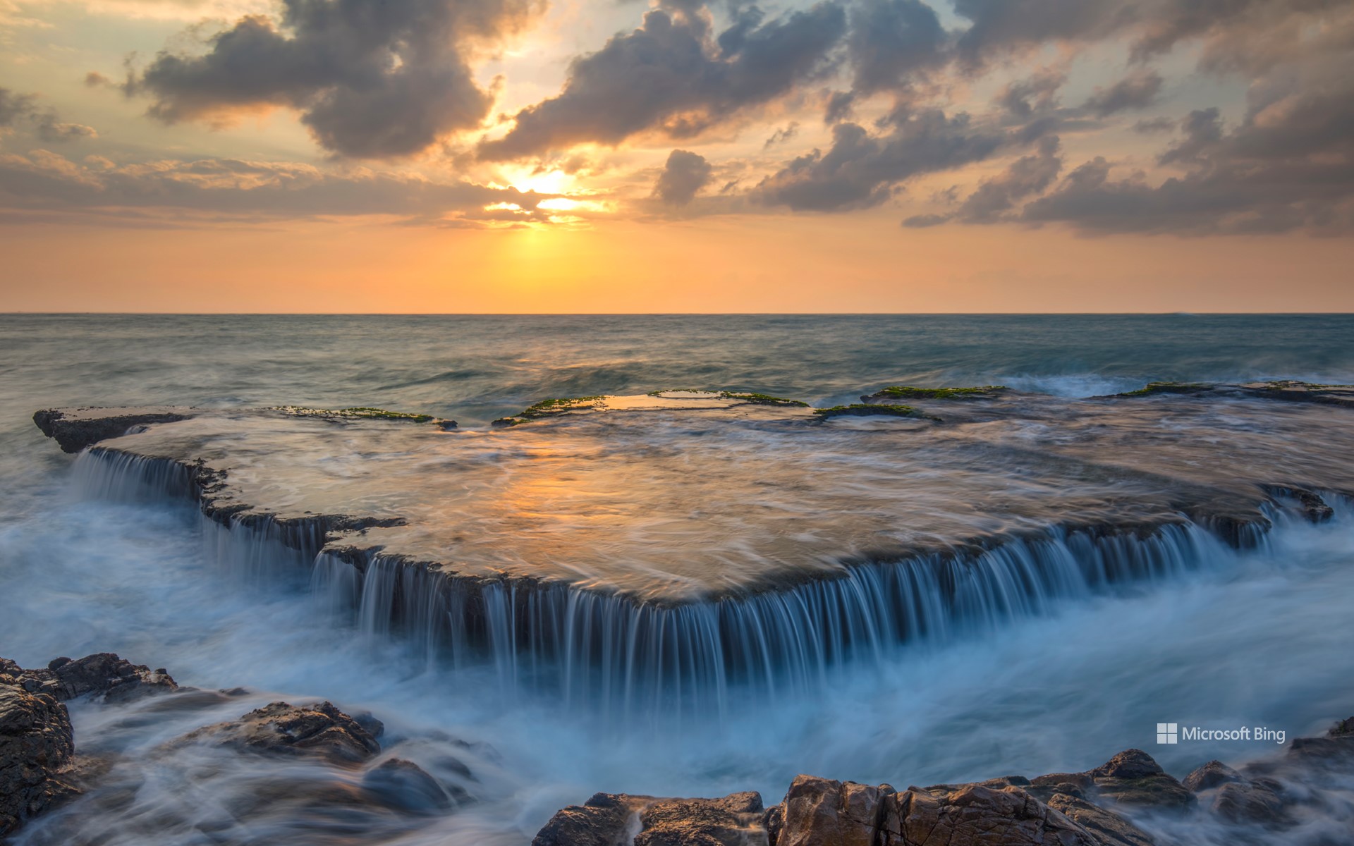
欢迎来到杭莱,这里既有古老的岩层,又有生机勃勃的珊瑚礁!这个洞穴也被称为獭洞,被努伊蔡国家公园包围着,是越南中南部海岸地区永希湾的一部分。该地区的天然珊瑚礁被岩层环绕,这些岩层堆叠在一起,形成了一组洞穴。“杭莱”或“獭洞”名称的由来之一,是人们偶尔会看到水獭在洞穴中栖息。另一种解释是由于该地区盛产莱树,这种树的油可以用于船只防水。无论是水下还是水上,这里都有令人惊叹的景观:深潜者可以观赏五颜六色的珊瑚,喜欢在海风中露营的游客可以欣赏美丽的日落。
Vinh Hy Bay, Vietnam
Welcome to Hang Rai, a blend of ancient rock formations and vibrant coral reefs. Also called Rai Cave, this cavern is part of the Vinh Hy Bay—enclosed by Nui Chua National Park—in the South Central Coast region of Vietnam. The area's natural coral reefs are surrounded by rock formations that are stacked upon each other to form a group of caves. One origin of the name 'Hang Rai' or 'Rai Cave' comes from otters (rai) that were occasionally seen seeking shelter in the caves. Another explanation is attributed to the abundance of rai trees in the area, whose oil was used to waterproof boats. The landscape is an awe-inspiring sight both under and above water: corals for deep divers and colorful sunsets for those who like camping in the sea breeze.
芽富湾,芽庄,越南 Nha Phu Bay, Nha Trang, Vietnam (© Thang Tat Nguyen/Getty Images)
芽富湾,芽庄,越南 Nha Phu Bay, Nha Trang, Vietnam (© Thang Tat Nguyen/Getty Images)
海湾之美 Beauty by the bay
芽富湾,芽庄,越南
芽富湾是越南芽庄市附近的一块宝地。世界各地的游客来到这个迷人的海湾,在美丽的岛屿周围浮潜,品尝美味的海鲜,享受惊险的水上运动等等。芽庄海湾的汉门群岛是越南唯一的官方海洋保护区所在地。猴子岛和兰屿也是芽富湾两个颇受欢迎的岛屿。顾名思义,猴子岛是数以万计的猴子的家园,比如灰毛猴、红脸猴等,而兰屿则生长着各种各样的兰花。
Nha Phu Bay, Nha Trang, Vietnam
Nha Phu Bay is a hidden treasure near the Vietnamese city of Nha Trang. Visitors from all over the world come here to snorkel, go island hopping, savor delicious seafood, and enjoy water sports. Hon Mun Island in Nha Trang Bay is the site of Vietnam's only official marine reserve. Here you can explore coral reefs teeming with fish, including snakeheads and cyprinids. Among the bay's popular attractions are Monkey Island which, as the name suggests, is home to gray-haired and red-faced monkeys, and Orchid Island, which boasts a great variety of orchid species.
薄雾笼罩的松树林,越南 Misty pine forest in the Central Highlands of Vietnam (© Thanh Thuy/Moment/Getty Images)
薄雾笼罩的松树林,越南 Misty pine forest in the Central Highlands of Vietnam (© Thanh Thuy/Moment/Getty Images)
Misty Pine Forest
The woods are a tranquil place, but can be scary for a lone wanderer. Out here, you could suddenly find yourself running from the big bad wolf, escaping a witch's clutches, or just plain old lost. Though often in the old stories, scary places like this are also where the hero overcomes a great obstacle or finds a valuable treasure. Could you be in luck?
The spindly pine forests of the Central Highlands of Vietnam, shown here, are the setting for many traditional tales of evil spirits and spells. But even if you don't believe in all that magic stuff, a forest can still feel enchanted when twilight bathes the misty air. Just don't lose your way out here…
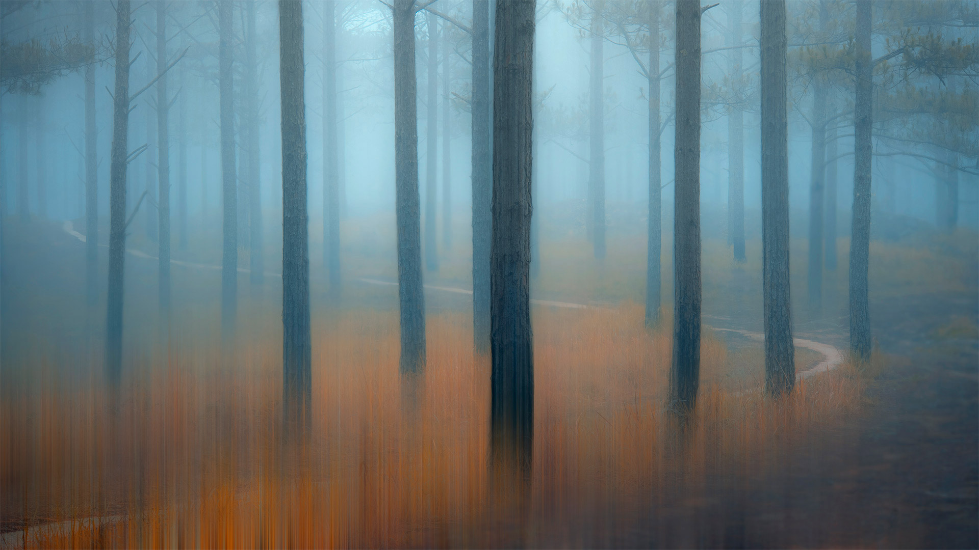
雾松林
森林是一个宁静的地方,但对一个孤独的流浪者来说却很可怕。在这里,你可能会突然发现自己在逃离大灰狼,逃离女巫的魔爪,或者只是普通的迷失。虽然在古老的故事中经常出现,但像这样可怕的地方也是英雄克服巨大障碍或找到宝贵财富的地方。你运气好吗?
如图所示,越南中部高地细长的松林是许多传统邪灵和咒语故事的背景。但即使你不相信所有这些神奇的东西,当暮色沐浴在朦胧的空气中时,森林仍然会感到被施了魔法。只是别在这里迷路…
Ngo Dong河两岸的稻田美景,越南宁平省 Boats float by rice fields on the Ngo Dong River in Ninh Binh province, Vietnam (© Jeremy Woodhouse/Getty Images)
Ngo Dong河两岸的稻田美景,越南宁平省 Boats float by rice fields on the Ngo Dong River in Ninh Binh province, Vietnam (© Jeremy Woodhouse/Getty Images)
A river runs through rice fields
We're peering down the winding Ngo Dong River at a group of rowboats meandering through rice paddy fields. This is the Ninh Binh province in Vietnam, about 60 miles south of Hanoi. On these two-hour tours by traditional Vietnamese rowboat, visitors wend their way between limestone karst peaks, through grottoes, and, if they're lucky, by workers harvesting rice in the fields, their wide-brimmed hats shielding them from the sun. Perhaps the most spectacular time to take this river cruise is around harvest time in late May and early June when the paddy fields are awash in a golden glow with a backdrop of bright green hillsides. But don't be surprised if the person rowing your boat moves the oars from hands to feet. It's tradition here for rowers to take a break and let their legs take over.
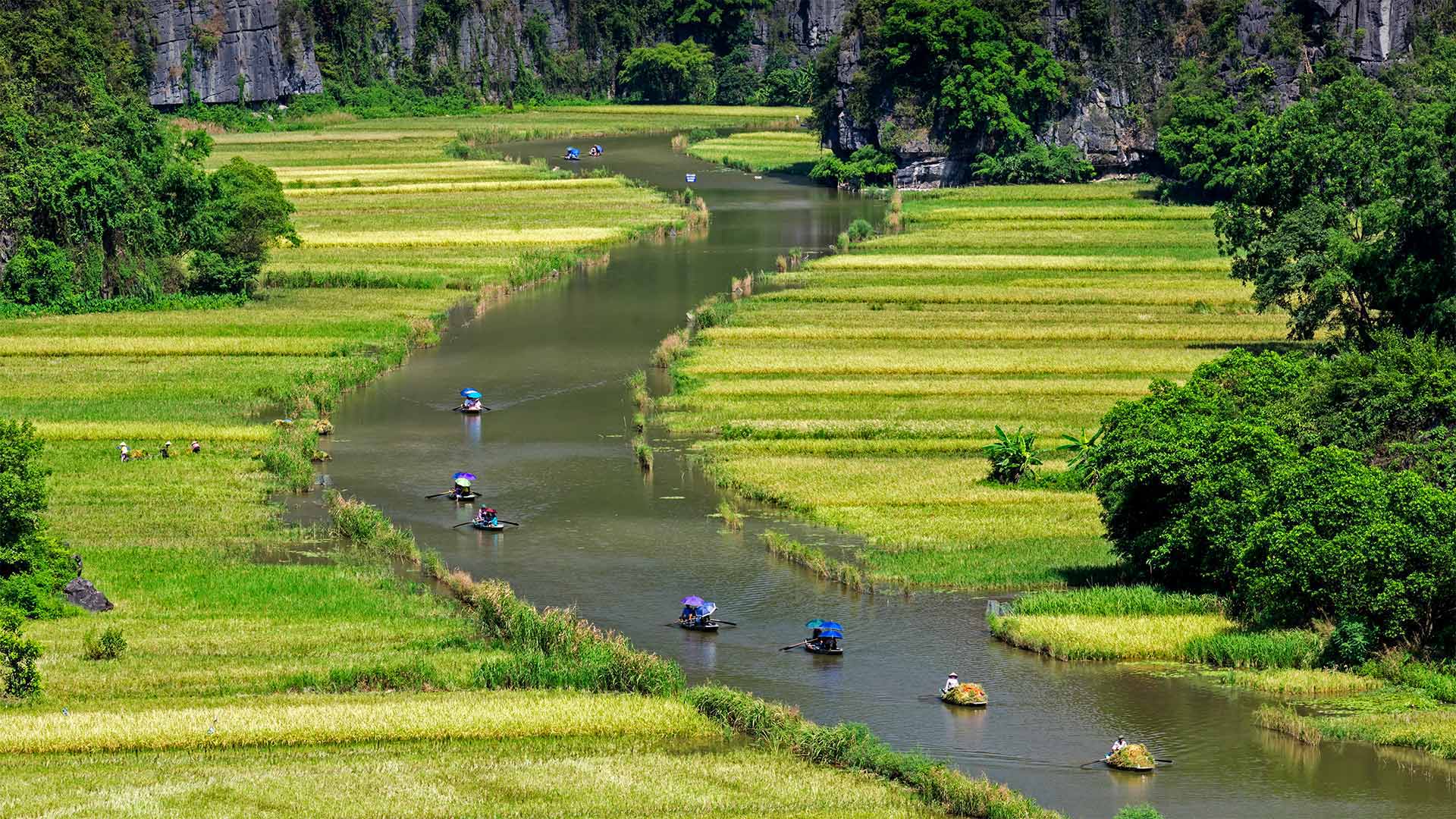
一条河穿过稻田
我们在蜿蜒的鄂东河上眺望,一群划艇蜿蜒穿过稻田。这是越南的宁平省,在河内以南大约60英里。在这两个小时的传统越南划艇之旅中,游客们穿梭于石灰岩喀斯特山峰之间,穿过石窟,如果幸运的话,还可以乘坐工人们在田里收割稻谷,他们戴着宽边帽遮挡阳光。也许最壮观的时候,采取这条河游轮是在丰收的时候,在5月底和6月初,当稻田淹没在一个金光闪闪的背景下明亮的绿色山坡。但是如果划船的人把桨从手移到脚,也不要感到惊讶。这里的传统是让划船者休息一下,让他们的腿来代替。
波来古市附近的Chu Dang Ya火山,越南嘉来 Chu Dang Ya near Pleiku in Gia Lai Province, Vietnam (© Quang Ngoc Nguyen/Alamy)
波来古市附近的Chu Dang Ya火山,越南嘉来 Chu Dang Ya near Pleiku in Gia Lai Province, Vietnam (© Quang Ngoc Nguyen/Alamy)
A sleeping green giant
We're looking down on Chu Dang Ya, an extinct volcano that last erupted millions of years ago. Located in the Gia Lai Province in the Central Highlands of Vietnam, Chu Dang Ya, means 'wild ginger' or perhaps 'tough ginger root' in the local Jarai language. The volcano provides fertile soil for crops such as pumpkins, sweet potatoes, taro, and more. Among the best times to visit this rural gem is at the beginning of the rainy season, in late April and early May, and as the rains wind down in November. That's when Chu Dang Ya takes it up a notch—its hillsides erupt with sunflower and other wildflower blooms along roadways, dirt paths, and fields.
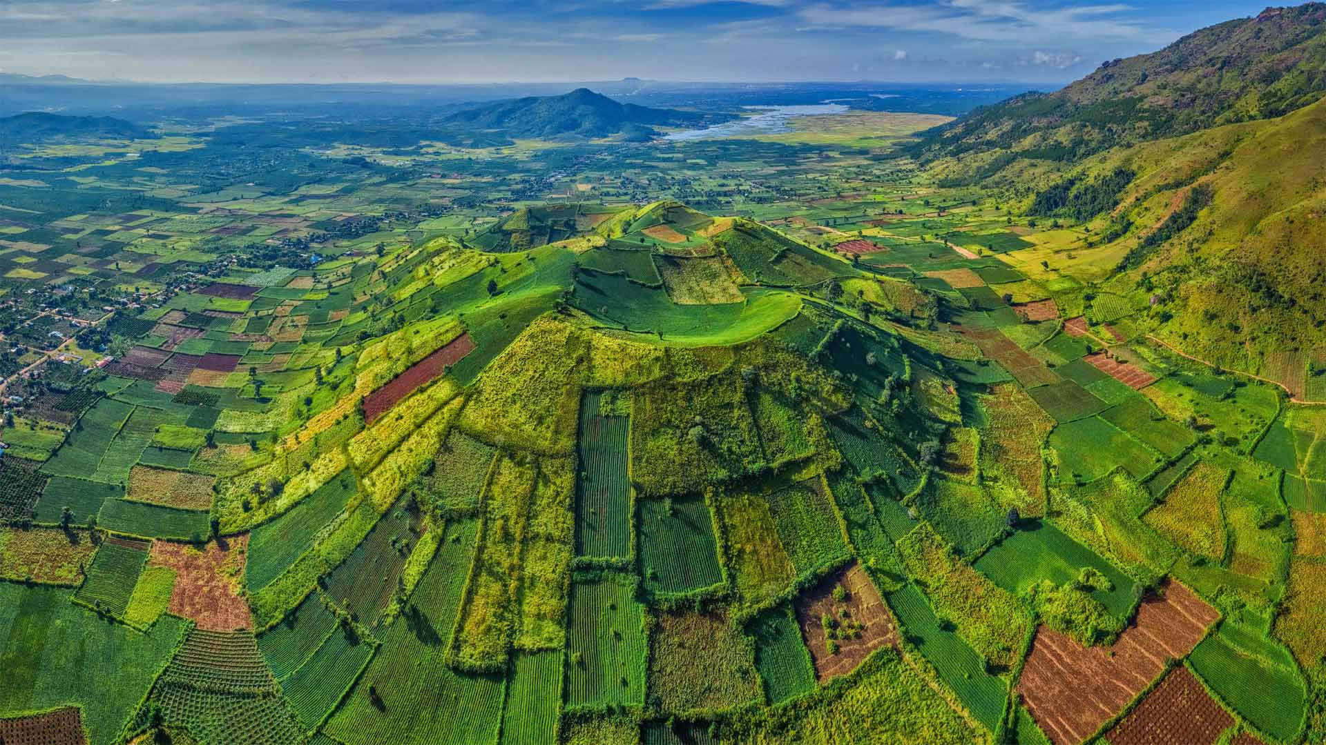
一个沉睡的绿色巨人
我们正在俯瞰楚荡崖,一座上一次喷发于数百万年前的死火山。楚当崖位于越南中部高地的嘉莱省,在当地的加莱语中,意思是“野姜”或“坚韧的姜根”。火山为南瓜、红薯、芋头等作物提供了肥沃的土壤。在雨季的开始、4月下旬和5月初,以及11月的雨季,参观这块乡村宝石的最佳时机之一。就在这时,楚当崖把它带上了一个台阶,山坡上开满了向日葵和其他野花,它们沿着公路、土路和田野盛开。
峰牙-己榜国家公园中的韩松洞,越南 Sơn Đoòng cave in Phong Nha-Kẻ Bàng National Park, Vietnam (© David A Knight/Shutterstock)
峰牙-己榜国家公园中的韩松洞,越南 Sơn Đoòng cave in Phong Nha-Kẻ Bàng National Park, Vietnam (© David A Knight/Shutterstock)
A universe underground
When Vietnamese farmer Hồ Khanh stumbled upon this cave in 1991, it was immediately clear the gaping mouth led to a huge, dark, untouched chamber, complete with a free-flowing underground river. What couldn't have been clear to him then was that this cave, now known as Sơn Đoòng, is by far the world's largest in volume.
Lacking gear to explore the cave further, Khanh could only wander back home and tell friends about his discovery. But he was unable to retrace his steps to the cavern, his tracks engulfed by the jungle. Relegated to rumor, the cave went unexplored for almost two decades until a visiting team of British cavers caught wind of Khanh's tale. In 2009, Khanh led them to Sơn Đoòng after a long search, and explorations commenced that found the cave was vast beyond anyone's expectations.
Sơn Đoòng is over 1.5 billion cubic feet in volume, with its main chamber 650 feet high, almost 500 feet wide, and stretching more than 3 miles, large enough to fly a Boeing 747 through—but look out for the 15-story stalagmites. One of the cave's massive dolines—sunken, sun-exposed sections like the one seen here—hosts an entire rainforest ecosystem. And that's just what we know so far: Cave divers have yet to fully explore Sơn Đoòng's subterranean river, and vast passages found as recently as 2019 have only added to what's known of the cave's enormity.
地下的宇宙
1991年,当越南农民HồKhanh偶然发现了这个洞穴时,人们立刻清楚地看到,张开的洞口嘴通向一个巨大的、黑暗的、未被触及的洞穴,里面有一条自由流动的地下河。当时他不清楚的是,这个洞穴,现在被称为SơnĐoòng,是迄今为止世界上最大的洞穴。
由于缺乏进一步探索洞穴的装备,卡恩只能漫步回家,告诉朋友他的发现。但他无法回到洞穴,他的足迹被丛林吞噬。由于流言蜚语的影响,这个洞穴在近20年的时间里一直未被发现,直到一队英国探洞者闻到了卡恩的故事。2009年,Khanh带领他们经过长时间的搜寻,来到了SơnĐoòng,开始了探险,发现这个洞穴的面积超出了任何人的预期。
SơnĐoòng的体积超过15亿立方英尺,其主舱室高650英尺,宽近500英尺,长度超过3英里,足以让一架波音747飞机通过,但要注意15层楼高的石笋。洞穴中一条巨大的低谷下陷,暴露在阳光下,就像这里看到的一样,这里有一个完整的雨林生态系统。而这正是我们目前所知道的:洞穴潜水员还没有完全探索sơnĐoòng的地下河,而最近在2019年发现的巨大通道只是增加了人们所知的洞穴的巨大性。
Bàu Cá Cái的红树林,越南广义 Bàu Cá Cái mangrove forest in Quảng Ngãi Province, Vietnam (© Robert Harding World Imagery/Offset)
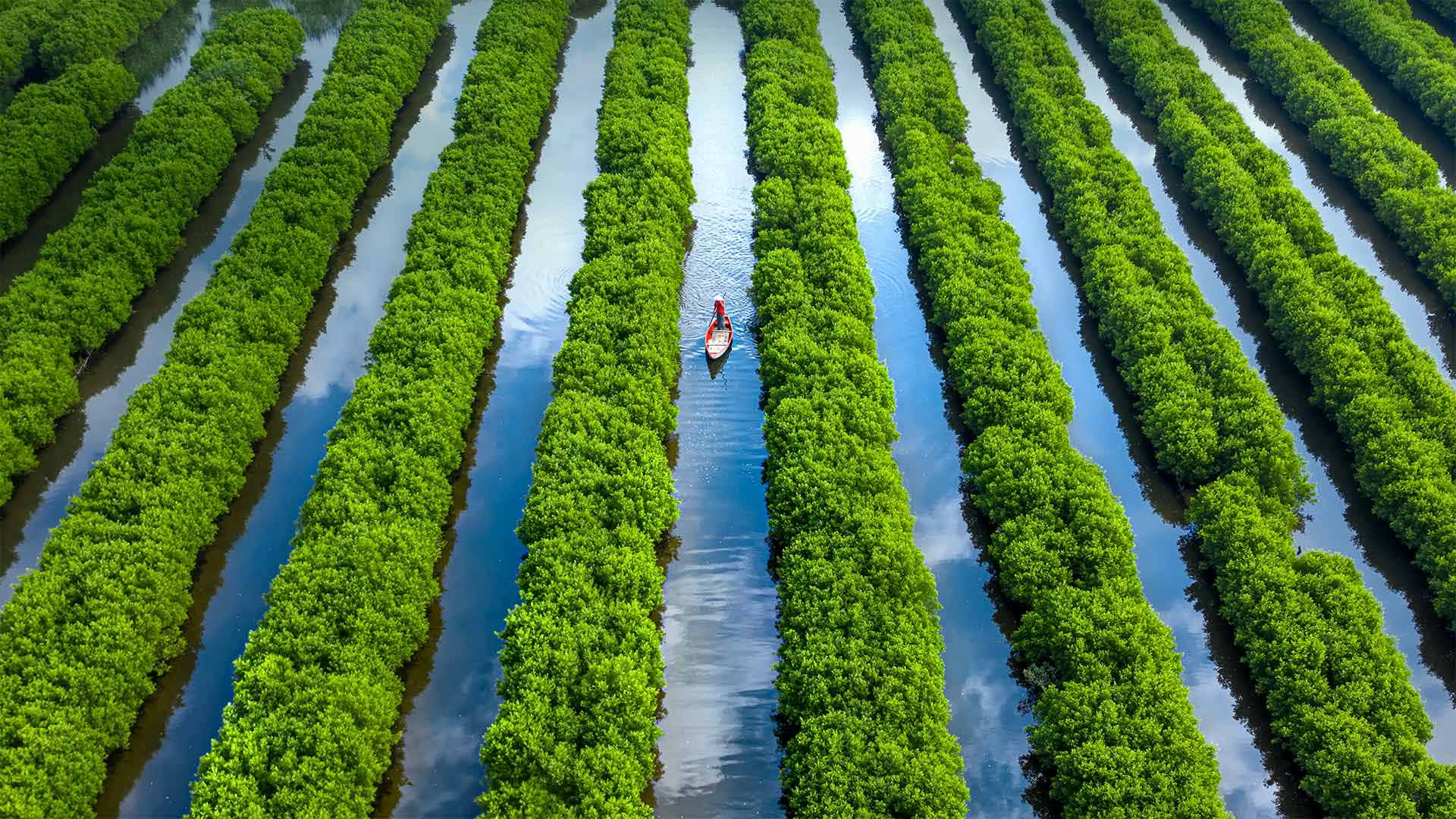
Bàu Cá Cái的红树林,越南广义 Bàu Cá Cái mangrove forest in Quảng Ngãi Province, Vietnam (© Robert Harding World Imagery/Offset)
How Quảng Ngãi got its grove back
Could these humble rows of trees prevent a natural disaster? The Vietnamese government hopes so. Mangrove forests like Bàu Cá Cái in coastal Vietnam's Quảng Ngãi Province are an important shield against destructive typhoons that rock the coast each year. Unfortunately, mangrove trees have been depleted over the years by population growth, climate change, and increased use of waters for fish farming. Plantings at Bàu Cá Cái—outlined by bamboo frames to create the neat patterns seen here—have been part of a major initiative to regenerate nearly 10,000 acres of mangrove forest around the country.