2021年1月
巴伐利亚阿尔卑斯山脉中的米滕瓦尔德小屋,德国 Mittenwalder Hütte in the Bavarian Alps of Germany (© Sebastian Frölich/Offset by Shutterstock)
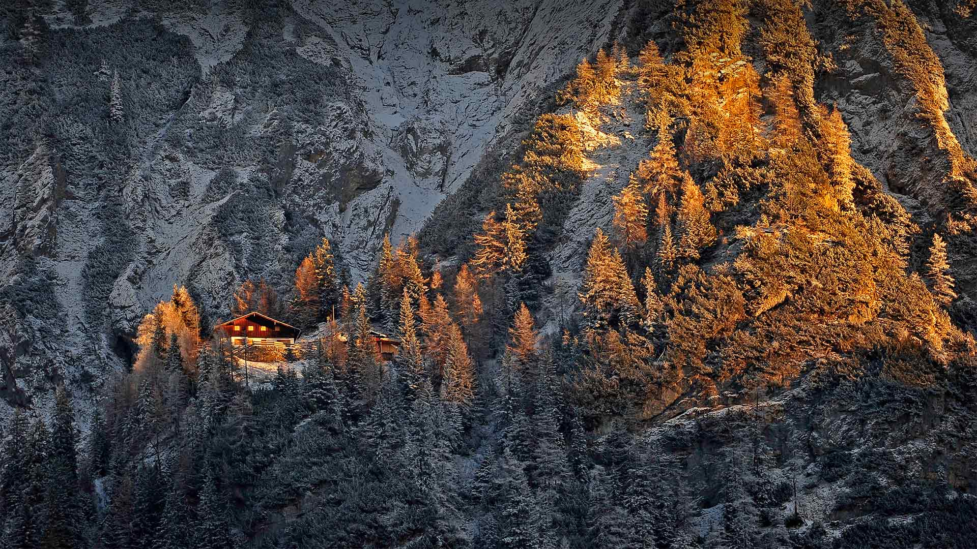
巴伐利亚阿尔卑斯山脉中的米滕瓦尔德小屋,德国 Mittenwalder Hütte in the Bavarian Alps of Germany (© Sebastian Frölich/Offset by Shutterstock)
A glittering diamond in the rough
Peering from this vantage point you may wonder, how in the world could anyone access this hut nestled in the Bavarian Alps? By hiking in, of course. There are well over 1,000 such huts dotting the Alpine landscape throughout Europe, most of them built and maintained by private social clubs devoted to climbing, hiking, and other activities in the mountains. These huts allow hikers to light out onto the extensive trail systems, sometimes for days, while carrying as little gear as possible. No need to pack cooking equipment, tents and sleeping bags when you have guaranteed shelter each night, with dinners, breakfasts, and, if you're lucky, a hot shower, included.
Do pack earplugs and a sleeping bag liner, as most of the beds are lined up next to each other in a dormitory setting. And don't try booking for this time of year. The hiking season in the Bavarian Alps typically begins in mid-May and lasts through the end of October. Weather, and COVID, permitting of course.
原石中闪闪发光的钻石
从这个有利的角度看,你可能会想,世界上怎么会有人能进入这个坐落在巴伐利亚阿尔卑斯山的小屋?当然是徒步旅行。在整个欧洲的阿尔卑斯山上,有1000多个这样的小屋,其中大多数都是由专门从事登山、徒步旅行和其他山区活动的私人社交俱乐部建造和维护的。这些小屋让远足者可以在尽可能少的携带装备的情况下,在广阔的步道系统中轻松行走,有时甚至可以持续数天。如果你保证每晚都有住处,就不需要打包烹饪设备、帐篷和睡袋,包括晚餐、早餐,如果你幸运的话,还可以洗个热水澡。
一定要带上耳塞和睡袋衬垫,因为在宿舍里,大多数床都是并排的。不要在一年中的这个时候预订。巴伐利亚阿尔卑斯山的徒步旅行季节通常从5月中旬开始,持续到10月底。当然,如果天气允许的话。
斯瓦尔巴德全球种子库, 其闪闪发光的外墙由艺术家戴维·桑尼设计, 斯瓦尔巴特群岛, 挪威 Svalbard Global Seed Vault with a glittering facade designed by artist Dyveke Sanne, Svalbard, Norway (© Pal Hermansen/Minden Pictures)
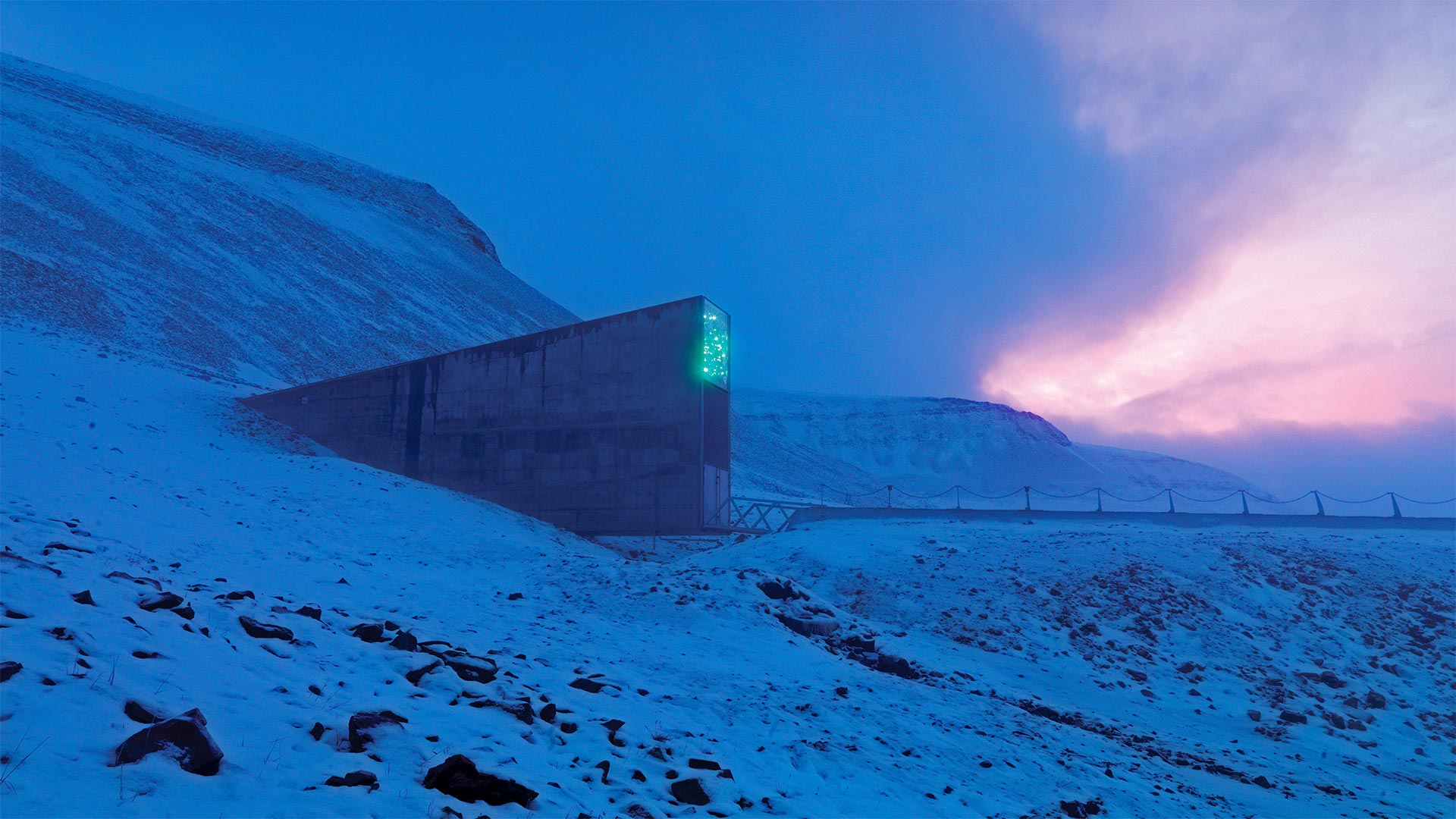
斯瓦尔巴德全球种子库, 其闪闪发光的外墙由艺术家戴维·桑尼设计, 斯瓦尔巴特群岛, 挪威 Svalbard Global Seed Vault with a glittering facade designed by artist Dyveke Sanne, Svalbard, Norway (© Pal Hermansen/Minden Pictures)
Even nature needs a backup plan…
This glittering monolith of cold metal is a lot like that still-sealed emergency survival kit languishing in your basement since 1999: Reassuring to have around, but a bummer when you actually have to use it. The Svalbard Global Seed Vault—better known by its cute nickname, the 'Doomsday Vault'—was established on this far-northern Norwegian isle in 2008 to archive frozen genetic copies of seeds already housed in seed banks around the world: a backup of all the backups. Kept at -0.4 degrees F within the Seed Vault, precious botanicals from food to fibers to flowers are safe from disasters, even of the apocalyptic variety. Lucky us: It'll take a healthy diet of veggies to fight off the zombies.
But hey, doomsday can wait. Today is Seed Swap Day, an event encouraging horticulture buffs to propagate positivity by trading their favorite species and strains. So, no matter how green your thumb, try to get your hands on some new seeds today—let's plant a future where this Arctic chamber can stay good and sealed.
即使是自然界也需要备份计划…
这颗闪闪发光的冰冷金属巨石很像自1999年以来一直在地下室里煎熬的那个密封的应急救生包:有人在身边让人放心,但当你真的不得不使用它的时候,它却让人扫兴。斯瓦尔巴特全球种子库(Svalbard Global Seed Vault)因其可爱的绰号“末日宝库”(The Doomday Vault)而闻名于世,该库于2008年在挪威这个遥远的北方岛屿上建立,目的是将已经存放在世界各地种子库中的种子的冷冻基因副本存档:所有备份的备份。保存在-0.4华氏度的种子库,珍贵的植物从食物到纤维到花都是安全的,即使是世界末日的品种。幸运的我们:这将需要一个健康的素食饮食来击退僵尸。
但是,世界末日可以等。今天是种子交换日,这是一个鼓励园艺爱好者通过交易他们喜爱的品种和品种来传播积极性的活动。所以,不管你的拇指有多绿,今天就试着去收获一些新的种子,让我们种下一个未来,让这个北极小屋保持良好和密封。
西西里岛陶尔米纳,意大利 Taormina, Sicily, Italy (© Juergen Schonnop/Getty Images)
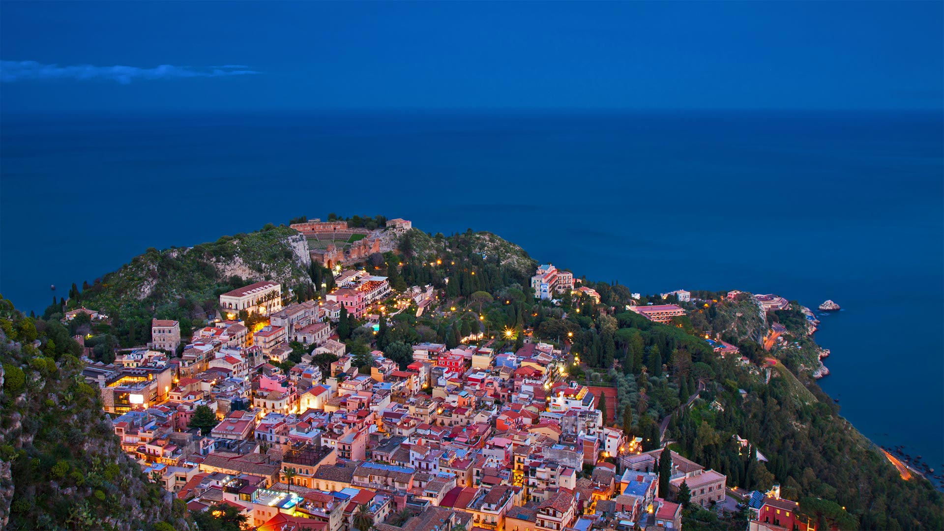
西西里岛陶尔米纳,意大利 Taormina, Sicily, Italy (© Juergen Schonnop/Getty Images)
A dramatic view of Sicily
If you mistook this gorgeous, postcard-worthy image for one of the many coastal towns along Italy's famous Amalfi coast, you wouldn't be far off. However, the town seen here actually lies farther to the south, located on the eastern side of Sicily, the largest island in the Mediterranean. Beginning in the late 19th century, sun-seeking tourists have come to the chic resort town of Taormina during the warmer months, looking to dine in its restaurants, relax on its beaches, and of course just to take in the exquisite scenery.
As expected in a town built over 2,000 years ago, traces of history can be found everywhere here, from the tiny medieval streets of old downtown to the Ancient Theatre of Taormina, an amphitheater built in the Greek style in the third century BCE, and later expanded by the Romans. And though it's been around for more than two millennia, the theater is still in use, with opera, theatrical productions, and concerts staged there to this day—or at least whenever performances aren't canceled due to the pandemic. The beauty of this town, built into a steep hill overlooking the Ionian Sea, is said to have inspired writers and thinkers both ancient and modern, from Plato to D. H. Lawrence to Truman Capote.
西西里岛的戏剧性景色
如果你把这张华丽的、值得放进明信片的照片误认为是意大利著名的阿马尔菲海岸沿岸众多沿海城镇之一,你就不会走得很远了。然而,这里看到的城镇实际上位于更远的南部,位于地中海最大岛屿西西里岛的东侧。从19世纪末开始,寻求阳光的游客在温暖的月份来到了别致的度假胜地陶尔米纳,他们希望在这里的餐厅用餐,在海滩上放松,当然也只是为了欣赏优美的风景。
正如人们所料,在一座建于2000多年前的小镇上,历史的痕迹随处可见,从旧城区的中世纪小街到陶尔米纳(Taormina)的古剧场,陶尔米纳是公元前3世纪希腊风格建造的圆形剧场,后来被罗马人扩建。尽管它已经存在了两千多年,剧院仍然在使用,歌剧、戏剧作品和音乐会一直在那里上演,至少在演出没有因为流感而取消的时候。这个美丽的小镇建在一座陡峭的小山上,俯瞰着爱奥尼亚海,据说从柏拉图到劳伦斯,再到杜鲁门·卡波特,它激发了古代和现代作家和思想家的灵感。
属于大堡礁的一部分的心形礁,澳大利亚昆士兰 Heart Reef, part of the Great Barrier Reef off Queensland, Australia (© Peter Adams/Offset by Shutterstock)
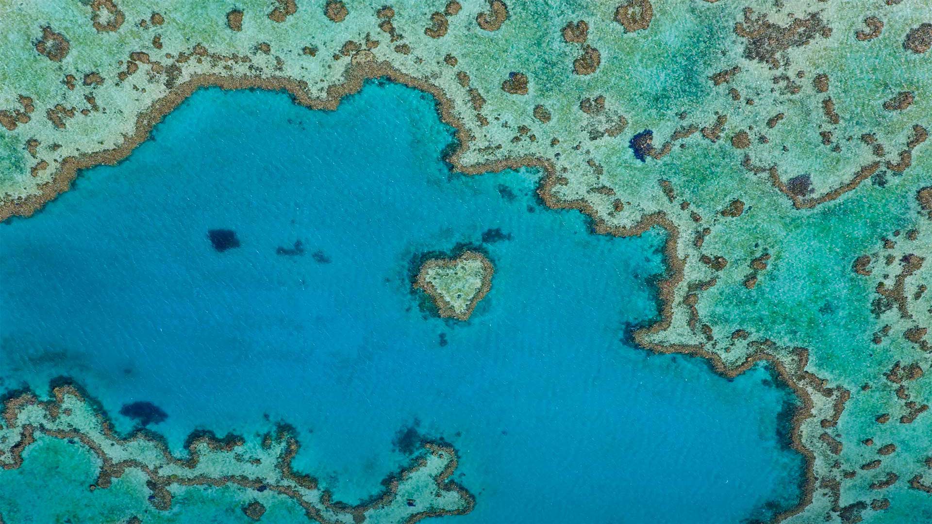
属于大堡礁的一部分的心形礁,澳大利亚昆士兰 Heart Reef, part of the Great Barrier Reef off Queensland, Australia (© Peter Adams/Offset by Shutterstock)
Didgeridoo you know what day it is?
If this aerial view of the Great Barrier Reef is a reminder that you ❤ everything Australia, today's your day. Australia Day commemorates January 26, 1788, when the first transplants from England said g'day to Australian shores, but you can just call it a day to celebrate all things Aussie. From the Barrier Reef to the rugged bush to the dry Outback, we invite you to join the diverse people of Oz in celebrating their island nation (well, we can almost join the Aussies—it's tomorrow for them already, so they celebrated yesterday).
Meanwhile, we presume you find yourself stuck in a Northern Hemisphere winter—so why not scroll Down Under and try our Australia Day quiz?
你知道今天是什么日子吗?
如果这张大堡礁的鸟瞰图提醒你❤ 澳大利亚的一切,今天是你的日子。澳大利亚日是为了纪念1788年1月26日,当时第一批从英国移植过来的人在澳大利亚的海岸上称为“国庆日”,但你可以称之为庆祝澳大利亚一切的日子。从大堡礁到崎岖的灌木丛,再到干旱的内陆,我们邀请你加入奥兹的不同民族庆祝他们的岛国(好吧,我们几乎可以加入澳大利亚人的行列,他们已经是明天了,所以他们昨天庆祝了)。
同时,我们假设你发现自己被困在北半球的冬天,那么为什么不向下滚动,试试我们的澳大利亚日测验呢?
红石公园教堂岩附近的雷击,新墨西哥州 Lightning strikes near rock formation, Church Rock, Red Rock Park, New Mexico (© Tim Fitzharris/Minden Pictures)
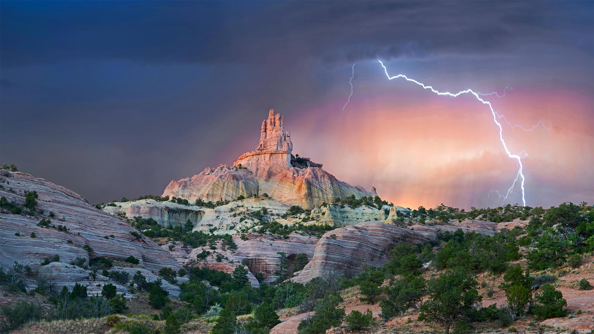
红石公园教堂岩附近的雷击,新墨西哥州 Lightning strikes near rock formation, Church Rock, Red Rock Park, New Mexico (© Tim Fitzharris/Minden Pictures)
Struck by Southwestern beauty
It's okay if this stormy shot stirs your spirit with holy awe: They call this wind-carved edifice Church Rock for a reason. Surrounded by an enchanting Southwestern landscape, it's a sight that almost invites you to get lost out here—and if you look at a map of these parts, you'll see that's not too hard.
We're in the 'checkerboard' region of western New Mexico, where patchwork borders separate sovereign Navajo Nation grounds and private land from that administered by an alphabet soup of federal, state, and local agencies. (For its part, Church Rock was the crown jewel of a state park before it was returned to the Navajo in 1989, while the city of Gallup now maintains the nearby parkland.) Maybe it's simpler to think in terms of a more ancient boundary line: The Great Continental Divide, marking the border between North America's Atlantic- and Pacific-destined waters, crosses Route 66 just east of the checkerboard.
为西南美景所震撼
如果这狂风暴雨的镜头激起你神圣的敬畏,那也没关系:他们称这座风雕大厦为教堂岩石是有原因的。四周环绕着迷人的西南景观,这种景象几乎会让您迷失在这里——如果你看看这些地方的地图,你会发现这不是太难。
我们在新墨西哥州西部的“棋盘格”地区,这里的边界错落有致,将纳瓦霍族主权国家的土地和私人土地与联邦、州和地方机构管理的土地分隔开来。(教堂岩在1989年被归还纳瓦霍之前是国家公园的王冠宝石,而盖洛普市现在保留着附近的公园。)也许用一条更古老的边界线来思考更简单:大洲分水岭,在北美洲大西洋和太平洋水域之间的边界,穿过66号公路,就在棋盘的东边。
波来古市附近的Chu Dang Ya火山,越南嘉来 Chu Dang Ya near Pleiku in Gia Lai Province, Vietnam (© Quang Ngoc Nguyen/Alamy)
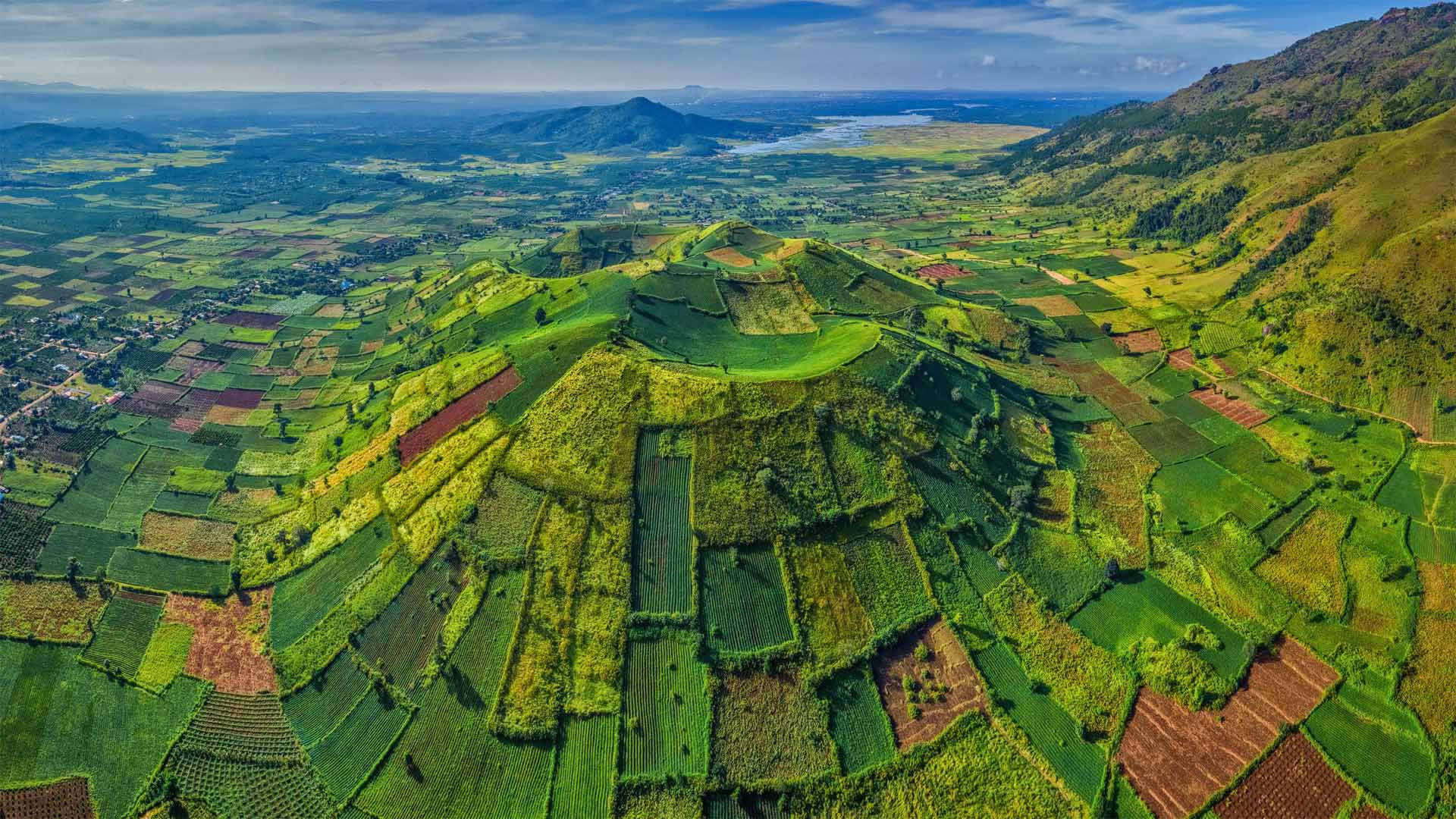
波来古市附近的Chu Dang Ya火山,越南嘉来 Chu Dang Ya near Pleiku in Gia Lai Province, Vietnam (© Quang Ngoc Nguyen/Alamy)
A sleeping green giant
We're looking down on Chu Dang Ya, an extinct volcano that last erupted millions of years ago. Located in the Gia Lai Province in the Central Highlands of Vietnam, Chu Dang Ya, means 'wild ginger' or perhaps 'tough ginger root' in the local Jarai language. The volcano provides fertile soil for crops such as pumpkins, sweet potatoes, taro, and more. Among the best times to visit this rural gem is at the beginning of the rainy season, in late April and early May, and as the rains wind down in November. That's when Chu Dang Ya takes it up a notch—its hillsides erupt with sunflower and other wildflower blooms along roadways, dirt paths, and fields.
一个沉睡的绿色巨人
我们正在俯瞰楚荡崖,一座上一次喷发于数百万年前的死火山。楚当崖位于越南中部高地的嘉莱省,在当地的加莱语中,意思是“野姜”或“坚韧的姜根”。火山为南瓜、红薯、芋头等作物提供了肥沃的土壤。在雨季的开始、4月下旬和5月初,以及11月的雨季,参观这块乡村宝石的最佳时机之一。就在这时,楚当崖把它带上了一个台阶,山坡上开满了向日葵和其他野花,它们沿着公路、土路和田野盛开。
横跨康涅狄格河畔血溪的铁路,新罕布什尔州汉诺威 Railroad crossing Bloody Brook alongside the Connecticut River in Hanover, New Hampshire (© DEEPOL by plainpicture)

横跨康涅狄格河畔血溪的铁路,新罕布什尔州汉诺威 Railroad crossing Bloody Brook alongside the Connecticut River in Hanover, New Hampshire (© DEEPOL by plainpicture)
Cold? What cold?
As the Scandinavian saying goes, 'There's no such thing as bad weather, just bad clothes.' The adventurer seen here, conquering the New England chill on a stand-up paddleboard, is a cold ocean removed from Nordic shores. But this watery winter excursion embodies the Scandie stamina distilled in the word 'friluftsliv,' literally translated 'free air life'—the notion that any time is a great time to be outdoors, weather be damned.
Friluftsliv has been part of Norse identity since Vikings and Goths eked out their existence in frozen fjords and forests. But it was Henrik Ibsen, the Norwegian master playwright, who brought the word into Nordic popular culture in the 1850s, imbuing it with national pride and folk spirituality. Now it's so woven in the fabric of Scandinavian life that some nonprofits are dedicated to friluftsliv, and many employers allot workers time to play outside—especially in winter, when daytime is brief and precious.
冷?什么冷?
正如斯堪的纳维亚谚语说的,'没有坏天气,只有坏衣服。在图片里看到的,在站立在冲浪板上的冒险家征服了新英格兰的寒意,是一个从北欧海岸退走的寒冷海洋。但是,这趟水上的冬季旅行体现了“friluftsliv”一词中提炼出的令人厌恶的耐力,字面意思是“自由空气生活”——即任何时候都是户外活动的好时机,天气真糟糕。
自从维京人和哥特人发现他们在冰冻的峡湾和森林中生存以来, 弗里卢夫特利夫一直是北欧身份的一部分。但正是挪威剧作家亨里克·伊布森(Henrik Ibsen)在19世纪50年代将这个词引入北欧流行文化,使之充满了民族自豪感和民间精神。现在,它已经融入了斯堪的纳维亚人的生活,以至于一些非营利组织都在致力于friluftsliv,许多雇主都会给工人分配时间在外面玩,尤其是在冬天,白天短暂而宝贵。
被丛林包围着的玛雅古城卡拉克穆尔遗址,墨西哥坎佩切 Ruins of the ancient Mayan city of Calakmul surrounded by the jungle, Campeche, Mexico (© Alfredo Matus/Shutterstock)
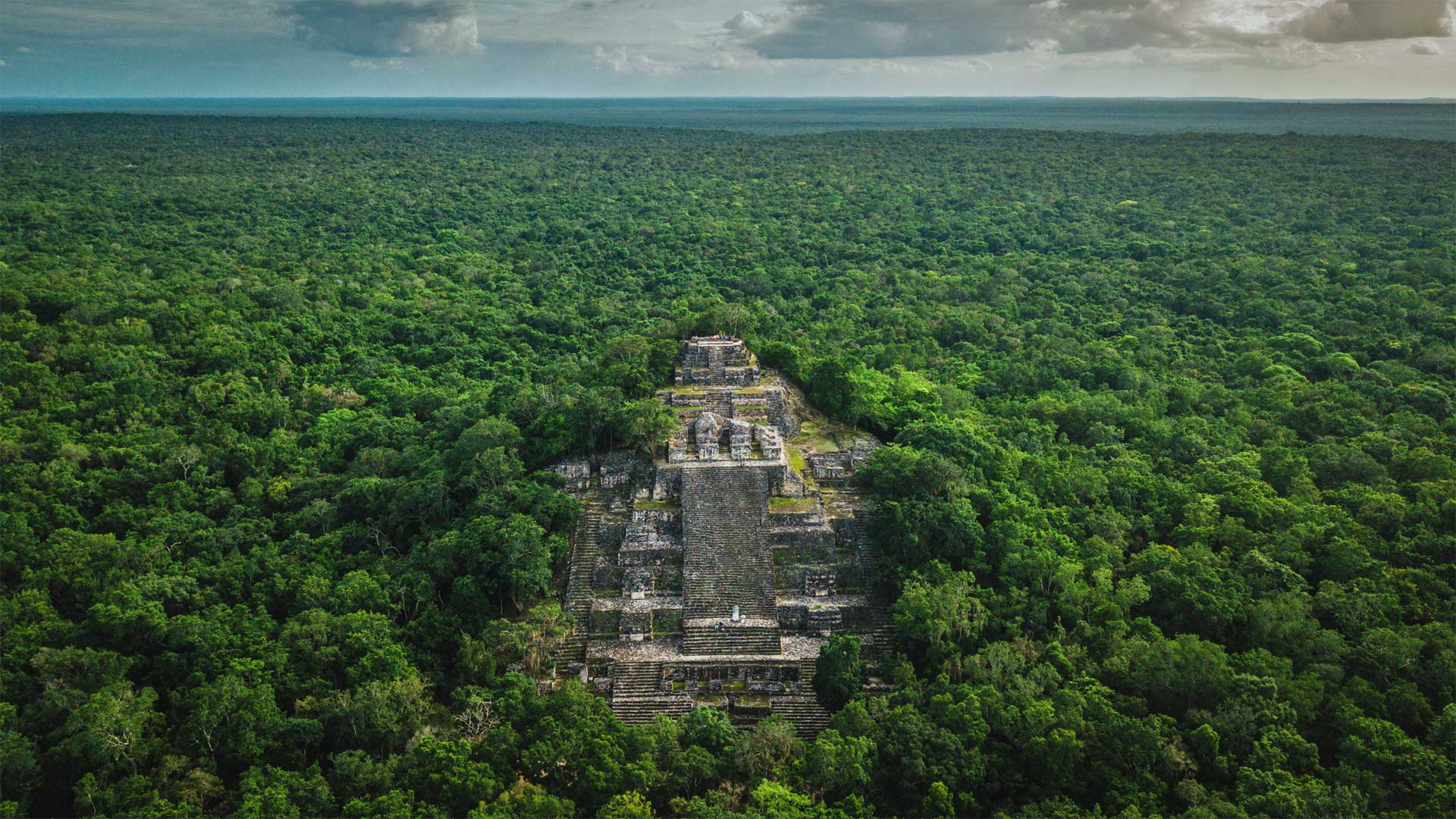
被丛林包围着的玛雅古城卡拉克穆尔遗址,墨西哥坎佩切 Ruins of the ancient Mayan city of Calakmul surrounded by the jungle, Campeche, Mexico (© Alfredo Matus/Shutterstock)
The ruins of a Mayan superpower
Deep in the jungle of southern Mexico lay the ruins of a city that thrived for centuries before it was abandoned more than 1,000 years ago. Calakmul was once one of the two dueling superpowers—along with Tikal—of the Classical Mayan civilization. At its height, around 1,200 years ago, the city of Calakmul had a population of about 50,000 people, but the kingdom as a whole numbered more than 1.5 million. Archaeologists have uncovered 6,750 structures here—the largest is this pyramid temple, called, simply, 'Structure 2.' It's one of the tallest and most massive remaining structures from that highly advanced culture. The ruins of the city proper cover nearly eight square miles in the jungle and the kingdom once ruled over settlements as far as 90 miles away.
All the more amazing, then, that it was apparently lost to history until an American botanist named Cyrus L. Lundell discovered it when flying over the jungle on a survey of the area in December 1931. A few expeditions were sent to explore it over the next few years, but it went largely unstudied until the 1980s. Calakmul is now recognized as one of the most important archeological sites in southern Mexico.
玛雅超级大国的废墟
在墨西哥南部的丛林深处,有一座城市在1000多年前被遗弃之前,已经繁荣了几个世纪。卡拉克穆尔曾是古典玛雅文明的两个决斗超级大国之一,与提卡尔一起。大约1200年前的鼎盛时期,卡拉克穆尔市的人口约为5万人,但王国整体人口超过150万。考古学家在这里发现了6750座建筑——最大的是这座金字塔神庙,简单地说,叫做"结构2"。它是高度先进文化中最高和最具大规模剩余结构之一。这座城市的废墟覆盖了丛林中近8平方英里的面积,王国曾经统治着90英里外的定居点。
更令人惊奇的是,它显然被历史所遗忘,直到1931年12月一位名叫赛勒斯·伦德尔的美国植物学家在一次对该地区的勘测中飞越丛林时发现了它。在接下来的几年里,一些探险队被派去探索它,但直到20世纪80年代它才被广泛研究。卡拉克穆尔现在被认为是墨西哥南部最重要的考古遗址之一。卡拉克穆尔现在被公认为墨西哥南部最重要的考古遗址之一。
菲希特尔贝格山上的气象站和Fichtelberghaus酒店,德国上维森塔尔 Weather Station and Fichtelberghaus Hotel on Fichtelberg Mountain (1214m), Oberwiesenthal, Ore Mountains, Erzgebirge, Saxony, Germany (© Cornelia Dorr/eStock Pho
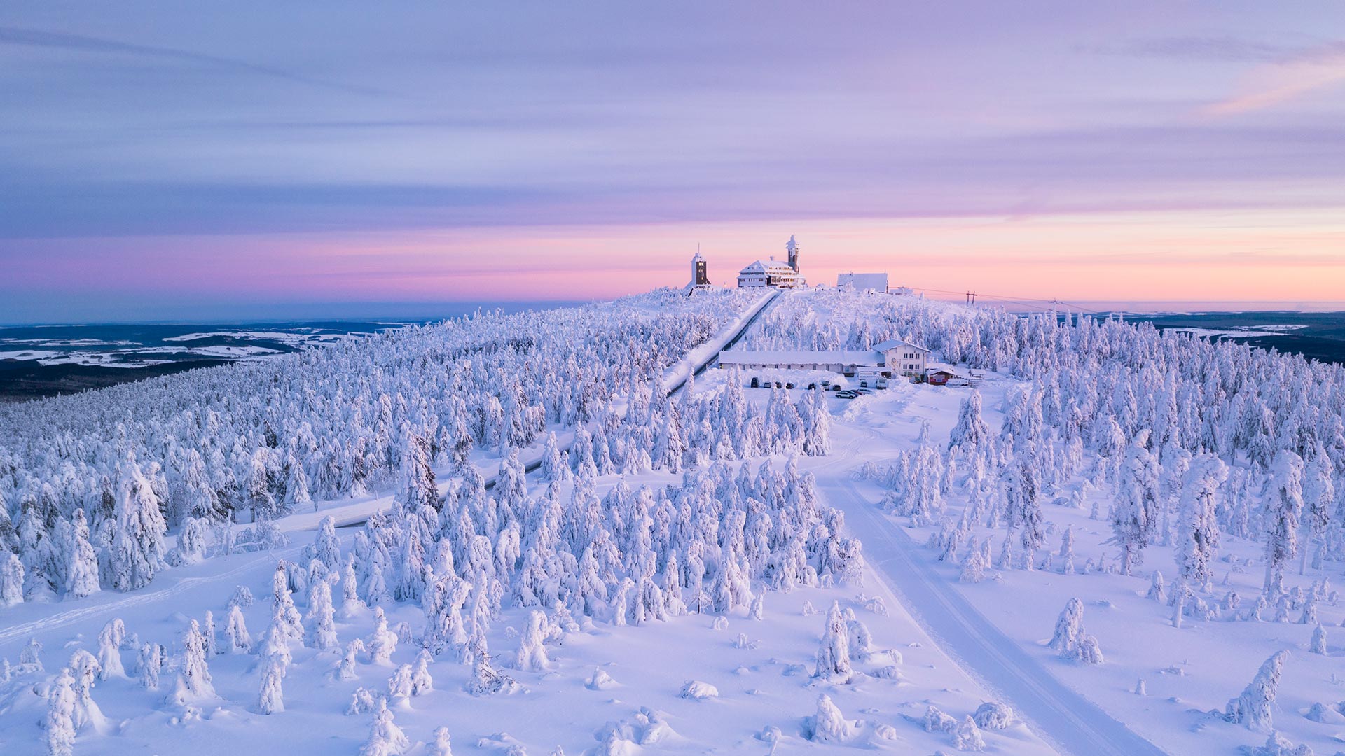
菲希特尔贝格山上的气象站和Fichtelberghaus酒店,德国上维森塔尔 Weather Station and Fichtelberghaus Hotel on Fichtelberg Mountain (1214m), Oberwiesenthal, Ore Mountains, Erzgebirge, Saxony, Germany (© Cornelia Dorr/eStock Photo)
Weather lights in the Ore Mountains
Lew Tolstoy would have had his true joy at this sight, and the picturesque winter landscape would surely have inspired him in the work of his epochal works. But neither Anna Karenina nor Father Frost found the way up to the Fichtelberg. Because today we do not show you a recording from Russia, but we take you on a trip to the Ore Mountains in Saxony.
The Ore Mountains are a mountain range in Saxony and Bohemia. The Fichtelberg near Oberwiesenthal is the highest mountain in Saxony, at around 1,214 metres. The spa town of Oberwiesenthal in the Pöhlbach valley is the highest town in Germany.
矿石山的天气灯
卢·托尔斯泰看到这一幕他会感到真正的喜悦,而如画的冬季风景肯定会激发他创作划时代作品的灵感。但是安娜卡列尼娜和弗罗斯特神父都没有找到通往费希特尔伯格的路。因为今天我们不给你们看来自俄罗斯的录音,而是带你们去萨克森的矿石山旅行。
矿石山是萨克森州和波希米亚山脉。奥伯维森塔尔附近的菲希特尔贝格山是萨克森州最高的山峰,约1,214米。位于波尔巴赫山谷的温泉小镇奥伯维森塔尔是德国最高的城镇。
巴尼奥斯附近的阿格杨瀑布,厄瓜多尔 Agoyán waterfall near Baños de Agua Santa, Ecuador (© Laura BC/Getty Images)
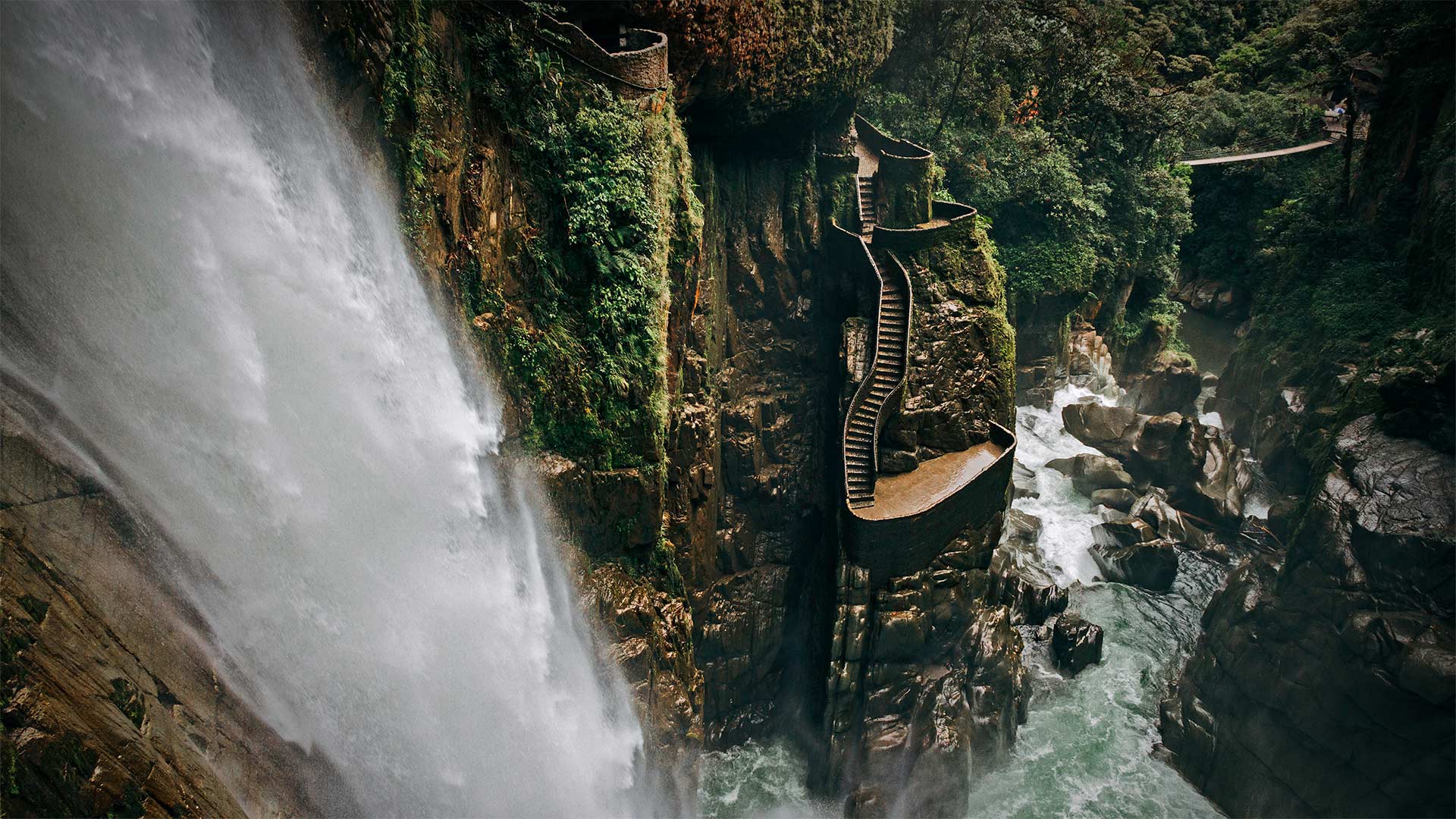
巴尼奥斯附近的阿格杨瀑布,厄瓜多尔 Agoyán waterfall near Baños de Agua Santa, Ecuador (© Laura BC/Getty Images)
On the Route of the Waterfalls
Coursing down the steep slopes of the Andes, just as the mountains meet the Amazon jungle, the Pastaza River is forced through a narrow channel, which concentrates its power like a firehose. The roiling torrent then shoots over the edge of this mountainside, plunging 200 feet into a cauldron-shaped pool. Agoyán, better known as El Pailón del Diablo (The Devil's Cauldron) is Ecuador's tallest and most famous waterfall. It's a highlight of the Ruta de las Cascadas (Route of the Waterfalls), a popular circuit of the many waterfalls and hot springs near the mountain town of Baños de Agua Santa.
Baños, as it's better known, is in the shadow of Tungurahua, one of South America's most active volcanoes. The once-sleepy town has become a gateway to the Amazon for outdoor adventurers who love to hike, zipline, rock climb, or bike down the mountain to this roaring cascade in the verdant jungle. Pro tip: Bring a rain jacket. The best way to experience the awesome power of The Devil's Cauldron is to walk onto a swaying suspension bridge and then follow the steep steps down the mountainside, around and behind the roaring curtain of water, literally soaking in the view.
与瀑布同行
帕萨扎河沿着安第斯山脉的陡坡蜿蜒而下,就在山脉与亚马逊丛林交汇之际,它被迫穿过一条狭窄的河道,像消防水龙带一样集中了它的力量。翻滚的激流随后从山腰边缘喷涌而出,注入200英尺深的一个大锅状的水池。阿戈安,俗称暗黑破坏神(魔鬼大锅),是厄瓜多尔最高、最著名的瀑布。它是瀑布之路(Ruta de las Cascadas)的一大亮点,瀑布之路是巴尼奥斯德阿古亚圣塔(Baños de Agua Santa)山镇附近众多瀑布和温泉的热门线路。
众所周知,巴尼奥斯位于通古拉瓦火山的阴影下,通古拉瓦火山是南美洲最活跃的火山之一。这个曾经沉睡的小镇已经成为户外冒险家通往亚马逊河的门户,他们喜欢徒步旅行、拉拉链、攀岩或骑自行车下山,来到这片葱茏丛林中咆哮的瀑布。职业小贴士:带件防雨夹克。体验魔鬼大锅令人敬畏的力量的最佳方式是,走上一座摇曳的吊桥,然后沿着陡峭的台阶下山,绕过咆哮的水幕,躲在水幕后面,尽情地沉浸在视野中。