2022年7月
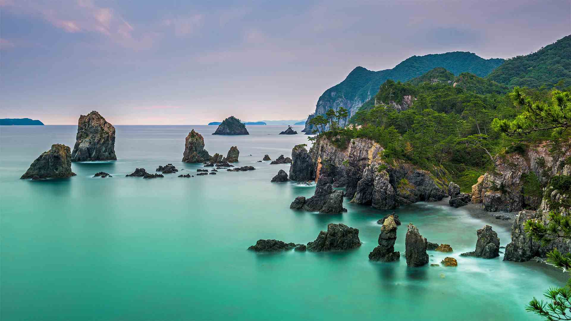
布满奇石的青海岛,日本北长门海岸国定公园 Omijima Island in Kita-Nagato Kaigan Quasi-National Park, Japan (© Sean Pavone Photo/Adobe Stock)
布满奇石的青海岛,日本北长门海岸国定公园 Omijima Island in Kita-Nagato Kaigan Quasi-National Park, Japan (© Sean Pavone Photo/Adobe Stock)
海上阿尔卑斯山 Alps of the sea
Marine Day in Japan
The striking coastline of Omijima Island has earned it the nickname 'The Alps of the Sea.' Its sheer cliffs and dramatic angles certainly echo the skyscraping peaks in that European mountain range. But a visit to Omijimi Island will take you to the other side of the world, to Kita-Nagato Kaigan Quasi-National Park, in Yamaguchi, Japan. Year-round scuba diving adventures reveal a world under the waves just as beautiful as the one above the surface.
日本的海洋日
大尾岛引人注目的海岸线为它赢得了“海洋阿尔卑斯山”的绰号它陡峭的悬崖和引人注目的角度肯定与欧洲那条山脉上的群峰相呼应。但是,游览大米岛将把你带到世界的另一边,日本山口的北长门凯根准国家公园。一年到头的水肺潜水冒险揭示了波浪下的世界和水面上的世界一样美丽。
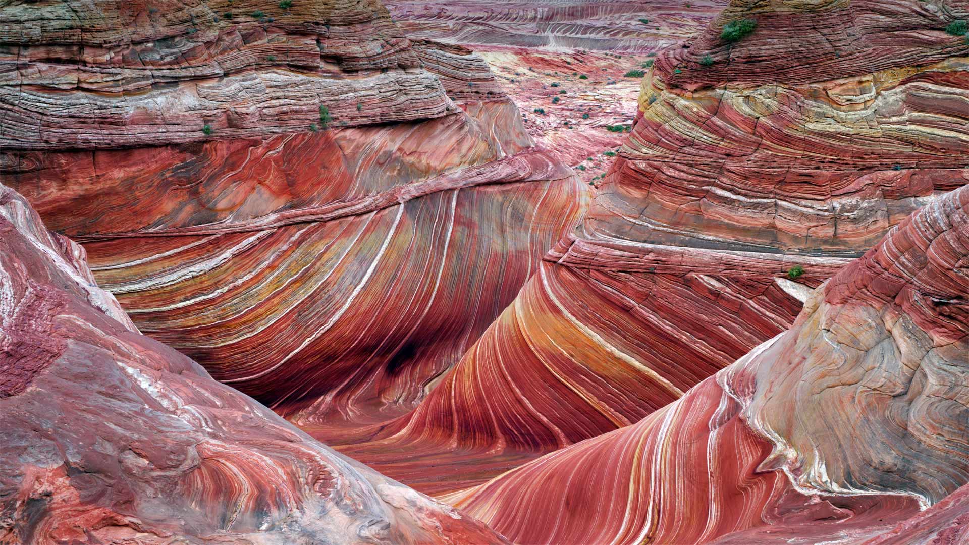
北狼丘里的"波浪谷",美国亚利桑那州 'The Wave' sandstone formation in Coyote Buttes North, Paria Canyon-Vermilion Cliffs National Monument, Arizona (© Dennis Frates/Alamy)
北狼丘里的"波浪谷",美国亚利桑那州 'The Wave' sandstone formation in Coyote Buttes North, Paria Canyon-Vermilion Cliffs National Monument, Arizona (© Dennis Frates/Alamy)
乘风破浪 Ride the wave
The Wave at Coyote Buttes
By showing you this coveted sight, we're saving you a bit of an ordeal. For a close-up view like this of 'The Wave,' a whorled sandstone formation in the northern Arizona wilderness, you'd have to navigate a rugged and mostly trail-free hiking route in typically scorching temperatures. You'd also need to have a permit in your pocket. To protect the landscape, only a small number are available, offered through a daily lottery. But maybe for you the journey is at least as important as the destination? If so, this is just one hike of many in the expansive Paria Canyon-Vermilion Cliffs National Monument, which protects more than 100,000 acres of Arizona and Utah canyonland.
郊狼丘上的波浪
通过向你们展示这一令人垂涎的景象,我们为你们省去了一点磨难。要想近距离拍摄“The Wave”,这是亚利桑那州北部荒野中的一个螺纹砂岩地层,你必须在典型的酷热天气下,沿着崎岖不平、几乎没有足迹的徒步路线行走。你还需要口袋里有许可证。为了保护景观,只有少数人可以通过每日彩票获得。但也许对你来说,旅程至少和目的地一样重要?如果是这样的话,这只是帕里亚峡谷朱红色悬崖国家纪念碑中众多徒步旅行中的一次,该纪念碑保护着亚利桑那州和犹他州超过10万英亩的峡谷地。
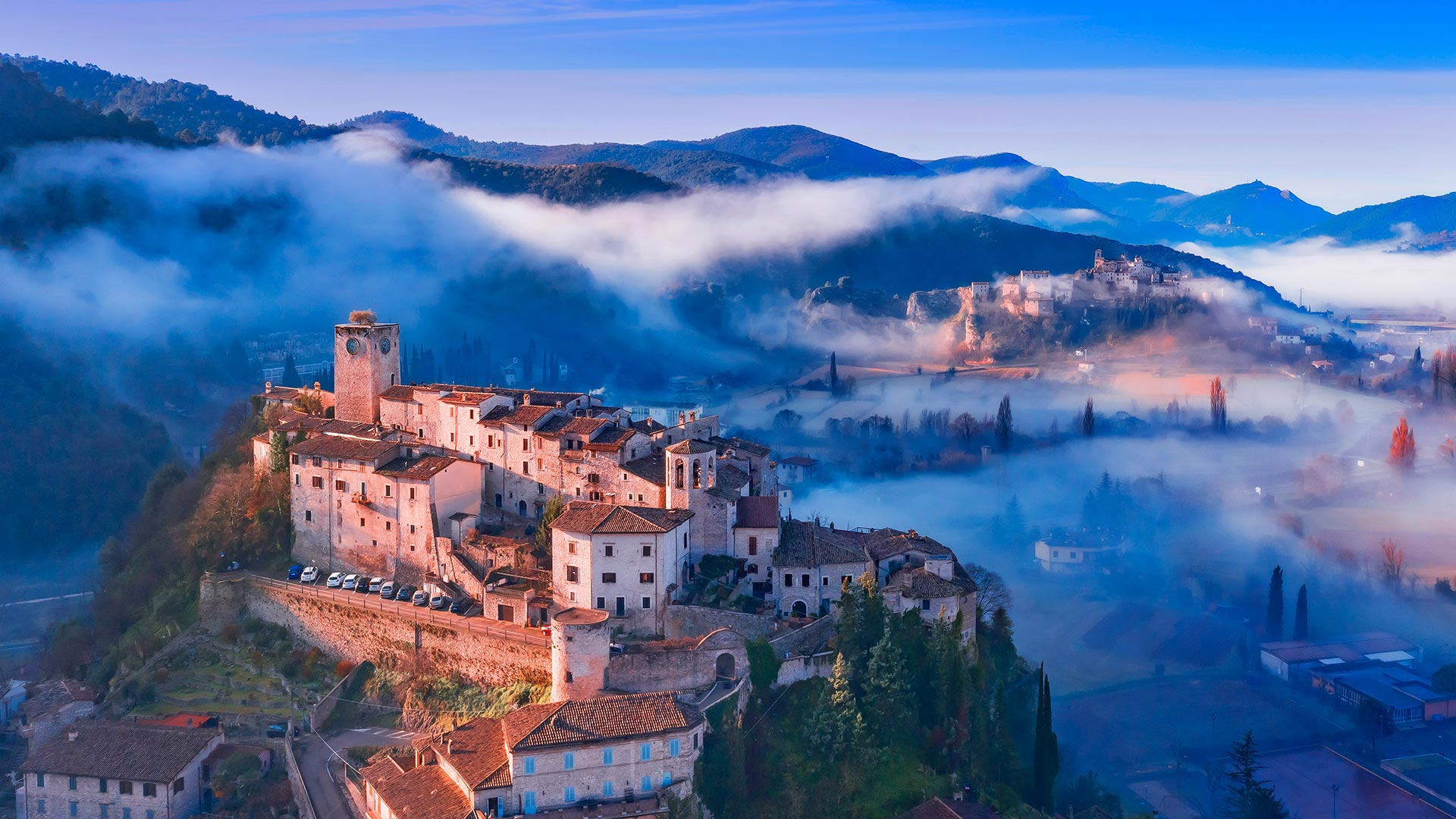
阿罗内镇的村落,意大利翁布里亚大区 The village of Arrone in Umbria, Italy (© Maurizio Rellini/eStock Photo)
阿罗内镇的村落,意大利翁布里亚大区 The village of Arrone in Umbria, Italy (© Maurizio Rellini/eStock Photo)
时光倒流...... Step back in time...
Arrone in Umbria, Italy
Close your eyes and picture a charming medieval Italian village, perched on a hill, church bells marking the hours, a hazy spread of patchwork fields fading into the distance. Well, that's the ancient village of Arrone. (On second thought, we probably didn't need the photo.) Arrone looks over the Valnerina, a valley carved by the river Nera, which twists its way through Italy's scenic Umbria region, known as the Green Heart of Italy.
When you stroll through the narrow alleys between 9th-century stone houses, it's like entering a time warp. Gaze out from the fortifications, imagining battles of the past. You'll easily spot the iconic square clock tower, with an ancient olive tree on top—it's what remains of the fortress built by the founders of the village, the Arroni family.
As you're walking through the past, make sure to visit both of Arrone's churches. Since you're at the top of the village—'la Terra,' to locals—explore the modest 13th-century San Giovanni Battista church and its stunning works of art. Check out the bell tower, too: The 'Campanari di Arrone' (bell ringers of Arrone) are guardians of traditional bell-ringing methods. In the village's lower section, you'll find the Church of Santa Maria Assunta, which is filled with gorgeous frescoes dating to the early-16th and 17th centuries. And don't forget to marvel at the 16th-century glazed terra-cotta sculptures. So many ways to explore history in such a little village.
意大利翁布里亚的阿隆
闭上眼睛,想象一个迷人的中世纪意大利村庄,坐落在一座小山上,教堂的钟声标志着时间,一片朦胧的错落有致的田野渐渐远去。嗯,那是阿隆的古村落。(仔细想想,我们可能不需要这张照片。)阿隆俯瞰瓦纳里纳,这是一个由内拉河雕刻而成的山谷,内拉河蜿蜒穿过意大利风景秀丽的翁布里亚地区,被称为意大利的绿色心脏。
当你漫步在9世纪石头房子之间的狭窄小巷时,就像进入了一个时间隧道。从防御工事向外凝视,想象过去的战斗。你很容易就能看到标志性的方形钟楼,上面有一棵古老的橄榄树,这是阿罗尼家族的创始人建造的堡垒的遗迹。
当你回顾过去时,一定要参观阿隆的两座教堂。既然你在“la Terra”村的顶端,当地人就可以探索13世纪的圣乔瓦尼·巴蒂斯塔教堂(San Giovanni Battista church)及其令人叹为观止的艺术品。也可以去看看钟楼:“坎帕纳里·迪·阿隆”(阿隆的敲钟者)是传统敲钟方法的守护者。在村庄的较低部分,你会发现圣玛利亚阿桑塔教堂,教堂内有16世纪和17世纪早期的华丽壁画。别忘了惊叹16世纪的釉面陶俑雕塑。在这样一个小村庄里,探索历史的方式有很多。
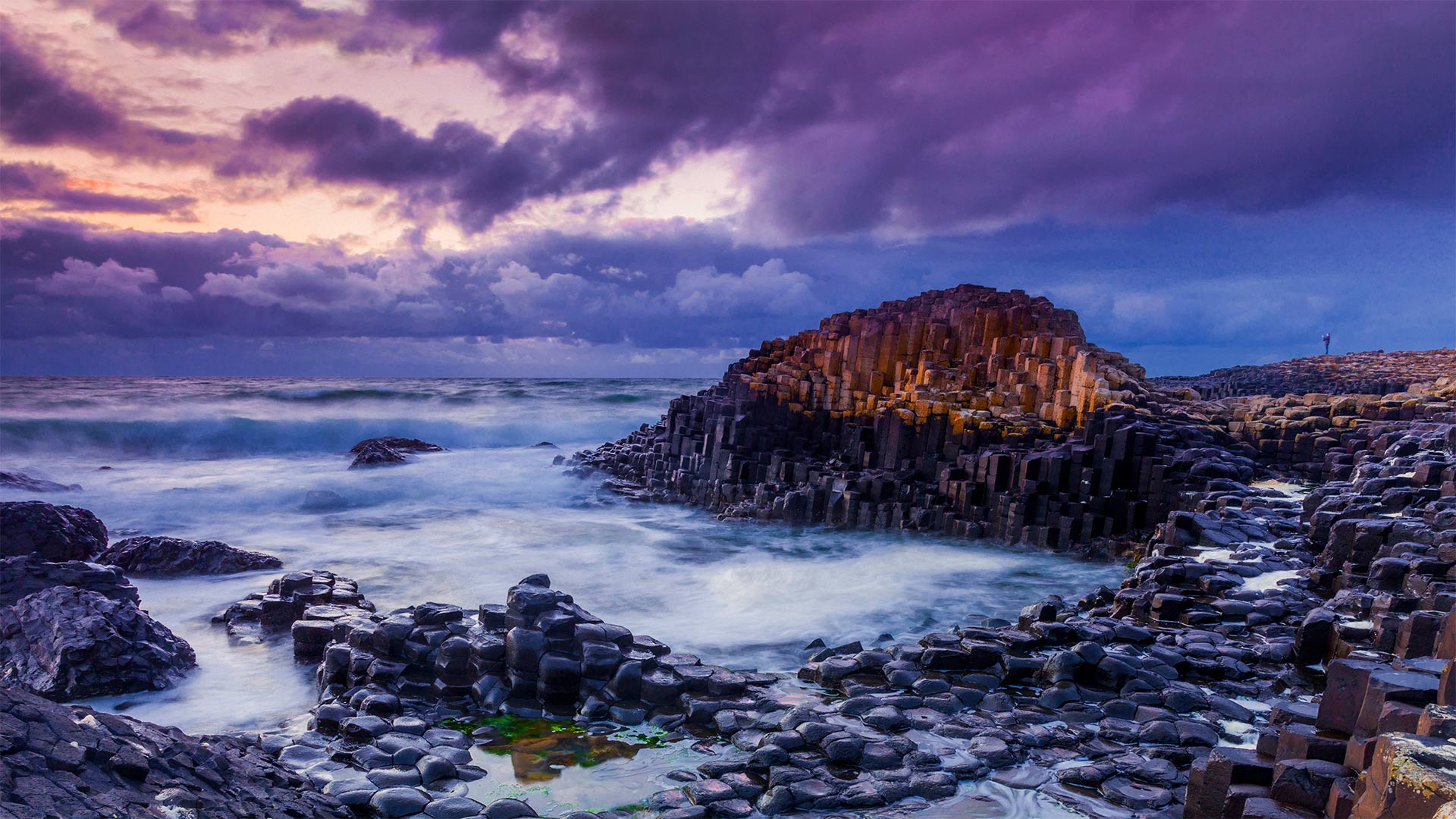
巨人堤道上的玄武岩柱,英国北爱尔兰 Basalt columns of Giant's Causeway, Northern Ireland, United Kingdom (© Olimpio Fantuz/eStock Photo)
巨人堤道上的玄武岩柱,英国北爱尔兰 Basalt columns of Giant's Causeway, Northern Ireland, United Kingdom (© Olimpio Fantuz/eStock Photo)
巨石中的巨石 Rocks rock!
International Rock Day
Today is International Rock Day and we're giving due respect to these geological wonders. It might seem odd to sing the praises of rock, but think about it. Rocks have been with humankind since the beginning. From tools to housing to weapons, they've been key to our survival. A period of our history was so reliant on rocks that it will be forever known as the Stone Age. We would not be where we are today without the many minerals found on our planet, so rock on!
To celebrate, we're going to focus on one marvelous rock in particular: basalt, the most abundant volcanic rock on Earth. Here at the Giant's Causeway in Northern Ireland, there are roughly 40,000 interlocking hexagonal columns of basalt formed after an ancient eruption. According to one Gaelic legend, however, this was built as a battleground for two giants, Ireland's Finn MacCool and Scotland's Benandonner. Another legend suggests MacCool built the causeway to cross the North Channel to meet a Scottish lover.
Revered as one of the United Kingdom's greatest natural wonders, the Giant's Causeway is one of the most popular tourist spots in Northern Ireland. If you can't make the journey, thanks to the way basalt naturally forms these polygonal columns, you could find some to construct a walkway of cobblestones to battle your own giants. At the very least, you'd have a sturdy rock that lasts the test of time.
国际岩石日
今天是国际岩石日,我们对这些地质奇观给予应有的尊重。歌颂摇滚乐似乎有些奇怪,但想想看。岩石从一开始就与人类同在。从工具到住房再到武器,它们一直是我们生存的关键。我们的历史中有一段时期是如此依赖岩石,以至于它将永远被称为石器时代。如果没有在我们的星球上发现的许多矿物质,我们就不会达到今天的水平,所以继续前进吧!
为了庆祝,我们将特别关注一种神奇的岩石:玄武岩,地球上最丰富的火山岩。在北爱尔兰的巨人堤道上,大约有40000个联锁的六角玄武岩柱,它们是在古代火山爆发后形成的。然而,根据盖尔人的一个传说,这里是两个巨人的战场,爱尔兰的芬恩·麦克库和苏格兰的贝南多纳。另一个传说是,麦考尔建造这条堤道是为了穿过北海峡去见一位苏格兰情人。
巨人堤被誉为英国最伟大的自然奇观之一,是北爱尔兰最受欢迎的旅游景点之一。如果你不能完成旅程,多亏了玄武岩自然形成这些多边形柱的方式,你可以找到一些用鹅卵石建造的走道来对抗你自己的巨人。至少,你会有一块坚固的石头,经得起时间的考验。
悉尼奥林匹克公园里的湾标瞭望台,澳大利亚 Bay Marker Lookout, Sydney Olympic Park, Australia (© ai_yoshi/Getty Images)
悉尼奥林匹克公园里的湾标瞭望台,澳大利亚 Bay Marker Lookout, Sydney Olympic Park, Australia (© ai_yoshi/Getty Images)
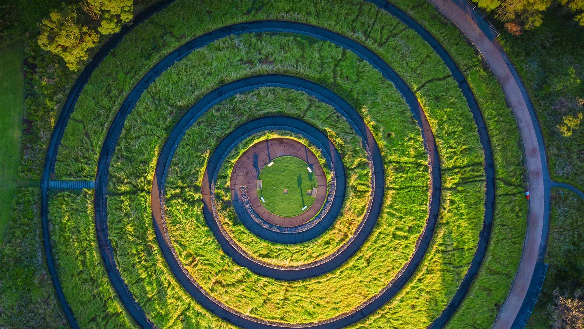
螺旋上升…… Spiraling upward...
Bay Marker Lookout, Sydney Olympic Park, Australia
It's an easy, circular trail to the Bay Marker Lookout, but you have to make it under your own steam—sorry, no cars allowed. This is one of the five Sydney Olympic Park Markers, cone-shaped earth mounds installed for the 2000 Olympics in Australia. They are cleverly placed to look from the air like the Australian flag's Southern Cross. From the ground, the Bay Marker gives a stunning full-360-degree view of Wentworth Common—a large grassy park—and the larger Olympic Park and stadium. You can also look over Homebush Bay (the community and the body of water) to the north. It's a dramatic melding of urban landscape, the city skyline, the wetlands and greenery, rivers, and beaches.
澳大利亚悉尼奥林匹克公园海湾标志了望台
这是一条通往海湾标志了望台的简单的环形小道,但你必须在自己的蒸汽下到达。对不起,不允许开车。这是悉尼奥林匹克公园为2000年澳大利亚奥运会安装的五个圆锥形土墩之一。它们被巧妙地放置在空中,看起来像澳大利亚国旗的南十字。从地面上看,海湾标志物可以360度全方位俯瞰温特沃斯公园(Wentworth Common),这是一个长满青草的大型公园,以及更大的奥林匹克公园和体育场。你也可以在北边俯瞰Homebush湾(社区和水体)。这是城市景观、城市天际线、湿地和绿化、河流和海滩的戏剧性融合。
巴塞罗那城市上空,西班牙 Barcelona, Spain (© SW Photography/Getty Images)

巴塞罗那城市上空,西班牙 Barcelona, Spain (© SW Photography/Getty Images)
城市规划永不停歇 Urban planning never stops
World Population Day
The bustling city streets of Barcelona seem as good a place as any to mark World Population Day. More and more of us are heading to the city. It's estimated that 2007 was the first year in which more people lived in cities than in rural areas. If current trends continue, by 2050 about two-thirds of the world population will be living in cities. City planners and government officials will need to account for this rapid increase as power grids, water supplies, public transit, and emergency services will all be stretched.
World Population Day was created by the United Nations in 1989 to focus attention on the urgency and importance of population issues. After hundreds of thousands of years, the world human population finally reached 1 billion around the year 1804. In just over 200 years since then it has exceeded 7.7 billion. It's expected to grow to around 8.5 billion in 2030, 9.7 billion in 2050, and 10.9 billion in 2100. How many is too many? What standard of living can we expect for people when the population exceeds 10 billion? And how many people can the planet sustain while also allowing nature to thrive? These are among the questions policy makers will confront as they consider the future of our world.
世界人口日
巴塞罗那繁华的城市街道似乎是纪念世界人口日的最佳场所。我们中越来越多的人正前往城市。据估计,2007年是城市人口比农村人口多的第一年。如果目前的趋势继续下去,到2050年,大约三分之二的世界人口将生活在城市。由于电网、供水、公共交通和应急服务都将捉襟见肘,城市规划者和政府官员将需要对这一快速增长做出解释。
世界人口日是联合国于1989年设立的,目的是使人们关注人口问题的紧迫性和重要性。几十万年后,世界人口终于在1804年左右达到10亿。从那以后的200多年里,它已经超过了77亿。预计2030年将增长到约85亿,2050年将增长到97亿,2100年将增长到109亿。多少是太多?当人口超过100亿时,我们能期望人们的生活水平如何?在允许自然繁荣的同时,这个星球还能维持多少人?这些是决策者在考虑世界未来时将面临的问题之一。
鸟瞰视角下的彩色船只,土耳其欧鲁旦尼斯 Aerial view of colorful boats in the Mediterranean Sea in Ölüdeniz, Turkey (© den-belitsky/Getty Images)
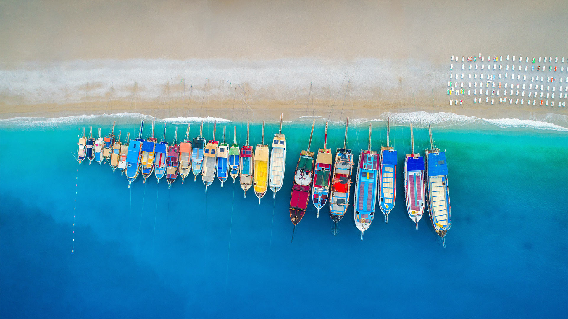
鸟瞰视角下的彩色船只,土耳其欧鲁旦尼斯 Aerial view of colorful boats in the Mediterranean Sea in Ölüdeniz, Turkey (© den-belitsky/Getty Images)
绚丽多彩的海滩 A beach of many colors
Ölüdeniz, Turkey
Whether you love snorkeling, scuba-diving, swimming, paragliding, or simply soaking up some sun, Ölüdeniz on Turkey's Turquoise Coast will fit the bill. The village and beach resort are named for the Blue Lagoon that's set off from the ocean by a long sandbar. (The literal translation of Ölüdeniz is 'Dead Sea,' reflecting the calm water, but for marketing purposes, the gorgeous color is more complimentary.) Much of the area is protected inside a national park, and the Ölüdeniz beach proudly holds the Blue Flag certification by the Foundation for Environmental Education, which recognizes high environmental and quality standards.
When you're all beached out, head for the hills. Ölüdeniz is one of the best paragliding spots in the world, so launch yourself from the impressive Mount Babadağ—just 3 miles from the seaside—and enjoy spectacular views of the lagoon, the beach, the Aegean and Mediterranean seas, and the scenic hills and valleys fading into the distance. Once you're back on solid ground, take a trip to the marvelous Butterfly Valley—it's easy, just jump on a taxi boat or drive the lovely local road that hugs the coast. Hopefully you'll spot a variety of butterflies as you hike through the natural canyon. Whether you go by air, land, or sea, there are so many ways to celebrate nature and diversity in this gorgeous part of the world.
欧鲁旦尼斯,土耳其
无论你喜欢浮潜、水肺潜水、游泳、滑翔伞,还是仅仅是晒晒太阳,土耳其绿松石海岸的欧鲁旦尼斯都是合适的选择。这个村庄和海滩度假胜地以蓝色的环礁湖命名,环礁湖由一个长长的沙洲与大海相望。(欧鲁旦尼斯的直译是“死海”,反映了平静的海水,但出于营销目的,华丽的颜色更具互补性。)大部分地区在国家公园内受到保护,而欧鲁旦尼斯海滩自豪地持有环境教育基金会的蓝旗认证,该基金会承认高环境和质量标准。
当你们都在海滩上时,往山上走。欧鲁旦尼斯是世界上最好的滑翔伞景点之一,因此,从令人印象深刻的巴巴达山出发——距离海边仅3英里,欣赏泻湖、海滩、爱琴海和地中海的壮丽景色,以及远处逐渐消失的风景如画的丘陵和山谷。一旦你回到坚实的地面上,就可以去奇妙的蝴蝶谷旅行。这很容易,只要跳上一艘出租车,或者开着可爱的当地公路,环抱海岸。希望你在穿越自然峡谷时能看到各种各样的蝴蝶。无论你乘飞机、陆路还是海运,在这个美丽的地方,有很多方式来庆祝大自然和多样性。
多洛米蒂山上空的银河,意大利 Dolomite Mountains at night with the Milky Way, Italy (© Carlos Fernandez/Getty Images)
多洛米蒂山上空的银河,意大利 Dolomite Mountains at night with the Milky Way, Italy (© Carlos Fernandez/Getty Images)
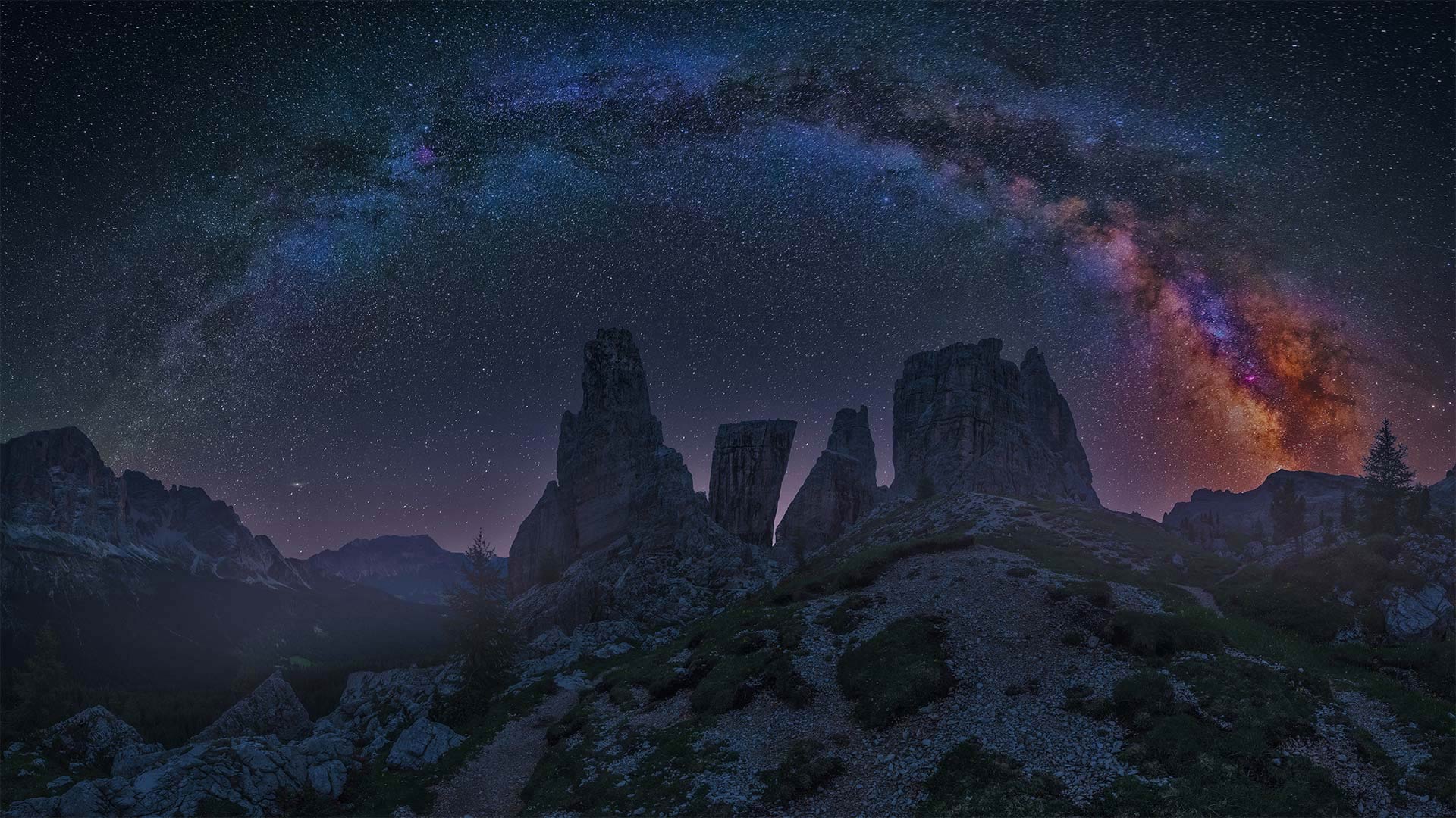
Dolomites
Few places in Europe offer the opportunity to take in the Milky Way like the Dolomites. Far from cities and light pollution, and thousands of feet above sea level, the Dolomites offer a stunning, vibrant night sky above shear, jagged peaks that cut the dark. Also known as the 'Pale Mountains,' the Dolomites are named for the carbonate rock they are composed of, which was in turn named after 18th-century French mineralogist Déodat Gratet de Dolomieu, the first scientist to describe the mineral.
The Dolomite region in northeastern Italy boasts more than 2,100 named mountains, including the 'Queen of the Dolomites,' Marmolada, whose Punta Penía is the highest peak of the range. Nature lovers, hikers, and climbers flock to the Dolomites in summer, and the slopes are dominated by skiers and snowboarders during the long winter months. One sure way to appreciate the Dolomites' impressive peaks is to take a hot air balloon over the range.
白云石
欧洲很少有地方像白云石那样有机会进入银河系。远离城市和光污染,海拔数千英尺,白云石在剪切、参差不齐的山峰上提供了一个令人惊叹的、充满活力的夜空,切断了黑暗。白云石也被称为“苍白山脉”,因其组成的碳酸盐岩而命名,而碳酸盐岩又是以18世纪法国矿物学家Déodat Gratte de Dolomieu的名字命名的,他是第一位描述这种矿物的科学家。
意大利东北部的白云石地区拥有2100多座被命名的山脉,其中包括“白云石女王”马尔莫拉达(Marmolada),其蓬塔彭尼亚峰(Punta Penía)是该山脉的最高峰。夏季,热爱大自然的人、徒步旅行者和登山者成群结队地来到白云石,在漫长的冬季,山坡上主要是滑雪者和滑雪者。欣赏白云石令人印象深刻的山峰的一个可靠方法是乘坐热气球飞越这一范围。
普雷维利峡谷里的河流和棕榈树森林,希腊克里特岛 Preveli Gorge with river and palm tree forest, South Chania, Crete, Greece (© borchee/Getty Images)
普雷维利峡谷里的河流和棕榈树森林,希腊克里特岛 Preveli Gorge with river and palm tree forest, South Chania, Crete, Greece (© borchee/Getty Images)
值得一去的魅力峡谷 A gorge-ous place to drop in
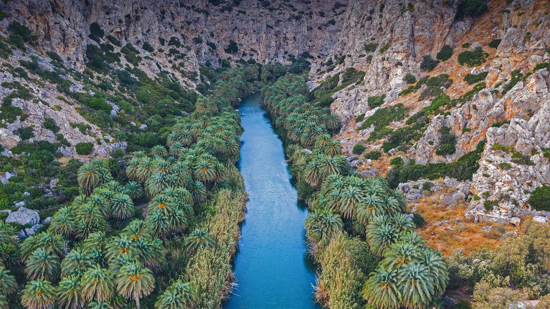
Prevali Gorge
Trojan War-era rest stop? Local legend has it that this striking and historic location in southern Crete was a stopover on Odysseus's long return to Ithica. Whatever credence you give to Homeric tales of island hopping, there's no denying the appeal of the palm-lined Preveli Gorge or the enchanting beach it pours out to. Preveli Beach, just out of the frame of this image, was a favorite spot for hippie travelers in the '60s and '70s and remains an idyllic tourist destination today.
Like most of the ancient, well-trodden Mediterranean islands, Crete—the largest of the many Greek isles—has a rich, epoch-spanning history. Here on Crete's southern coast, Preveli Gorge is home to an influential monastery with two building complexes: the Lower (Kato) Monastery of Saint John the Baptist and the Rear (Pisso) Monastery of Saint John the Theologian. The holy sites date back at least as far as the 16th century, and possibly had origins as far back as the 10th century.
During the long occupation of Crete by the Ottoman Empire, Preveli Monastery was a center of rebellion and patriotism, with monks often serving as leaders and warriors in the many revolts against the occupiers. After more than 250 years, Crete finally won its freedom and joined Greece in 1913. The monastery would again find itself at the center of world events when it provided shelter and supplies to Allied soldiers fighting German occupiers during World War II.
普雷瓦利峡谷
特洛伊战争时代休息停止?当地传说,这个位于克里特岛南部的引人注目的历史遗址是奥德修斯长期返回伊提卡的中途停留地。无论你如何相信荷马式的跳岛故事,都无法否认棕榈林环绕的普雷维利峡谷或它倾泻而出的迷人海滩的吸引力。普雷维利海滩,就在这张照片的框架之外,是60年代和70年代嬉皮士旅行者最喜欢的地方,今天仍然是一个田园诗般的旅游目的地。
克里特岛是希腊众多岛屿中最大的岛屿,与大多数古老、人迹罕至的地中海岛屿一样,有着丰富、跨越时代的历史。普雷维利峡谷位于克里特岛南部海岸,是一座有两座建筑群的有影响力的修道院的所在地:浸礼会圣约翰下(加藤)修道院和神学家圣约翰后(皮索)修道院。这些圣地至少可以追溯到16世纪,可能起源于10世纪。
在奥斯曼帝国长期占领克里特岛期间,普雷维利修道院是叛乱和爱国主义的中心,僧侣经常在许多反抗占领者的起义中担任领袖和战士。250多年后,克里特岛终于赢得了自由,并于1913年加入希腊。当修道院为二战期间与德国占领者作战的盟军士兵提供住所和物资时,它将再次成为世界事件的中心。
哈萨塔角灯塔,佛罗伦萨,俄勒冈州 Heceta Head Light, Florence, Oregon (© Tom Schwabel/Tandem Stills + Motion)
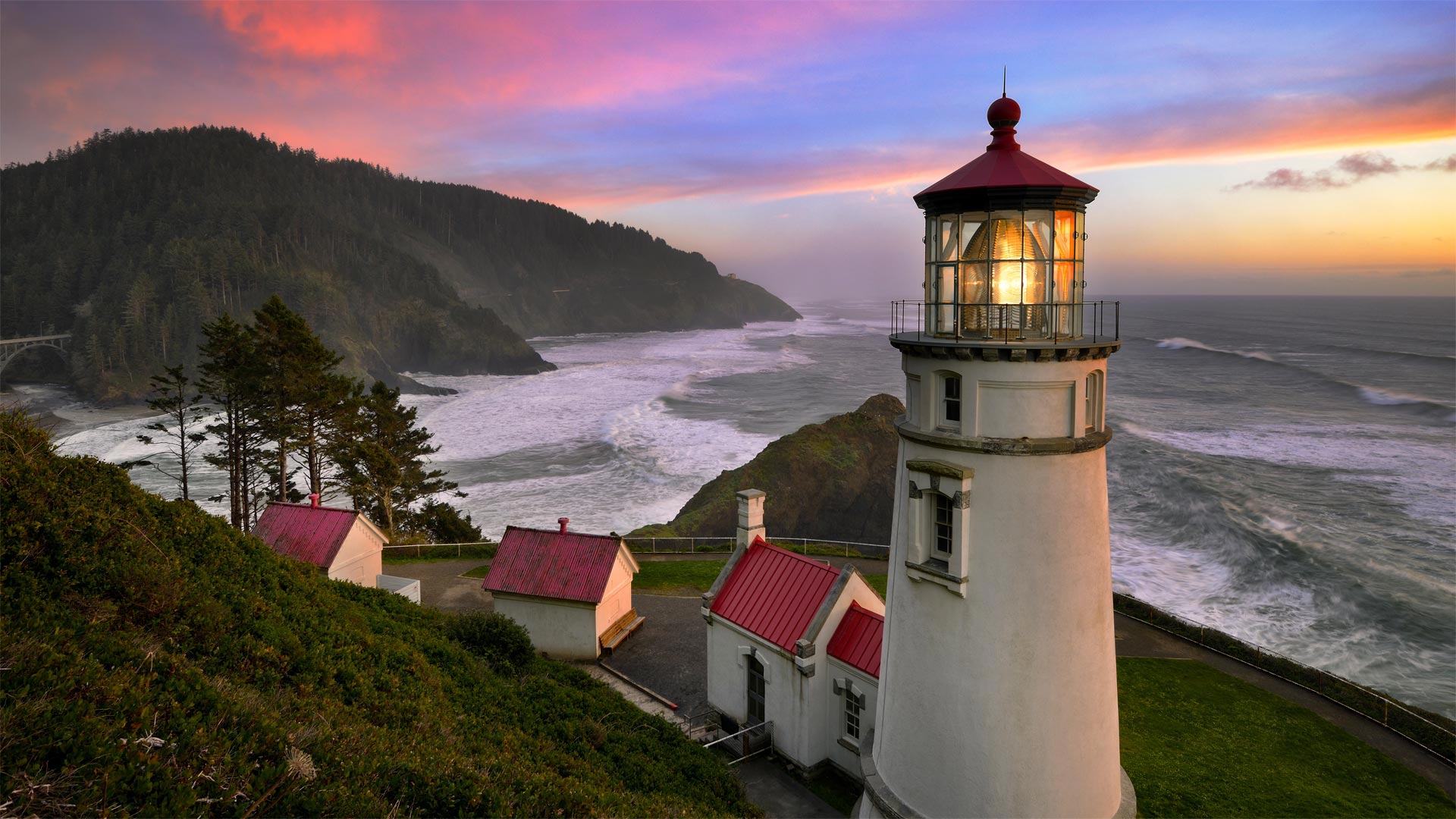
哈萨塔角灯塔,佛罗伦萨,俄勒冈州 Heceta Head Light, Florence, Oregon (© Tom Schwabel/Tandem Stills + Motion)
黑夜海岸边的一盏灯 A light in the coastal darkness
Heceta Head Light, Florence, Oregon
Heceta Head Light is perched 205 feet above the Pacific Ocean on Oregon's central coast. The headland is named for Spanish Basque explorer Don Bruno de Heceta, who led a secret expedition in 1775 to bolster Spain's claim to the Pacific Coast of North America. Having sailed from Mexico, by the time the voyage reached these shores, the crew was ravaged by scurvy and Heceta made the call to turn back—but not before he became the first to map and record a written description of the mouth of the Columbia River as well as this rocky 1,000-foot-high headland that would eventually bear his name. By the 19th century, seafarers making their way up and down the coast made the call for a lighthouse to guide their way. Construction of the 56-foot-tall lighthouse was complicated by the steep bluffs and remote location, but the first light beam pierced through the darkness on March 30, 1894.
The first lightkeepers at Heceta Head found the location too isolated, prompting several of them to leave the job after just a short period. Staffing turnover persisted until the 1930's when nearby Oregon Coast Highway was put into service and the area received electricity. The lighthouse played a minor role in World War II when 75 members of the Coast Guard and their dogs were stationed here to guard the beaches. The lighthouse became fully automated in 1963, and by 1970 the lightkeeper's house entered a new era as a satellite campus for a nearby community college. These days the area is on the National Registry of Historic Places and the lightkeeper's cottages have a new life as rooms of a bed and breakfast.
俄勒冈州佛罗伦萨哈萨塔角灯塔
哈萨塔角灯塔位于俄勒冈州中央海岸的太平洋上空205英尺处。岬角以西班牙巴斯克探险家唐·布鲁诺·德·赫切塔的名字命名,他于1775年领导了一支秘密探险队,以支持西班牙对北美太平洋海岸的主张。从墨西哥启航后,当航程到达这些海岸时,船员们被坏血病蹂躏,赫西塔呼吁掉头,但在他成为第一个绘制并记录哥伦比亚河口以及最终以他的名字命名的1000英尺高岩石岬角的书面描述之前。到了19世纪,在海岸上下航行的海员们呼吁建造灯塔来指引他们的航行。这座56英尺高的灯塔因陡峭的悬崖和偏远的地理位置而变得复杂,但1894年3月30日,第一束光线穿透了黑暗。
赫西塔海德的第一批灯管人员发现该地点过于孤立,促使他们中的几人在很短的时间内离开了工作岗位。人员流动一直持续到20世纪30年代,附近的俄勒冈州海岸公路投入使用,该地区通电。灯塔在第二次世界大战中发挥了次要作用,当时有75名海岸警卫队成员和他们的狗驻扎在这里守卫海滩。灯塔在1963年实现了全自动,到1970年,灯塔作为附近社区学院的卫星校园进入了一个新时代。这些天来,该地区已被列入国家历史遗迹登记册,灯塔的小屋作为一个床和早餐的房间有了新的生活。