标签 俄勒冈 下的文章
Wahclella Falls,哥伦比亚河峡谷,俄勒冈州,美国 Wahclella Falls in the Columbia River Gorge, Oregon (© Eric Vogt/Tandem Stills + Motion)
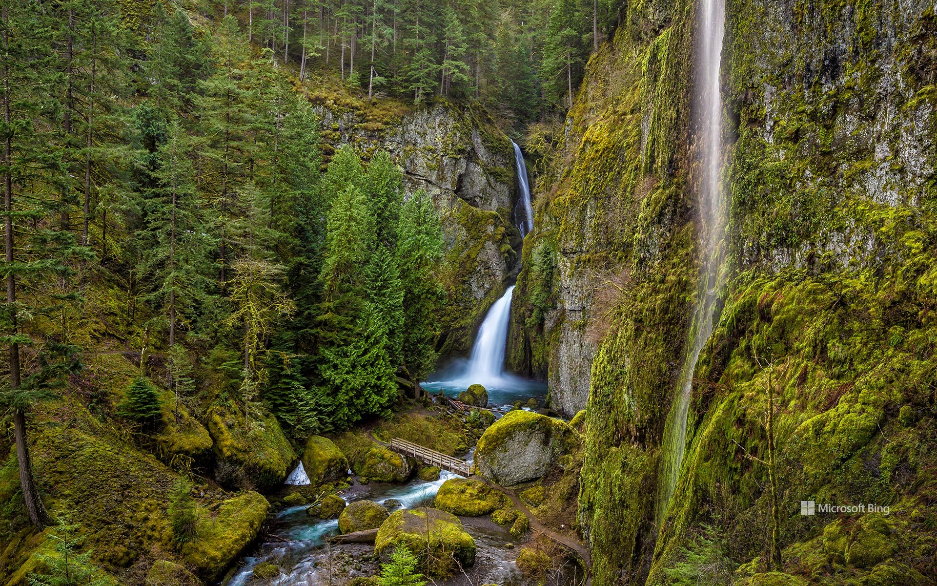
Wahclella Falls,哥伦比亚河峡谷,俄勒冈州,美国 Wahclella Falls in the Columbia River Gorge, Oregon (© Eric Vogt/Tandem Stills + Motion)
尽情地嬉戏玩水吧! Get your splash on
瓦克莱拉瀑布,俄勒冈州
在俄勒冈州一处狭缝型峡谷的尽头,有一个特别的地方正等待着徒步旅行者去探索:瓦克莱拉瀑布。其水源来自哥伦比亚河的支流坦纳河,这个瀑布的名字是由马扎马登山俱乐部的成员以美国原住民村庄的名字命名的。走到步行道的尽头,游客可以观赏到壮观的两级瀑布,水流从350英尺高的地方坠落到下面的水潭中,而这个水潭正是一个绝佳的玩水、纳凉胜地,当你在里面游泳的时候,可别忘了留意附近的水鸫(也被称为美洲河乌),这是一种以瀑布为家的鸟类。人们可以看到它们沿着溪流飞翔,偶尔也会潜入水中。
Wahclella Falls, Oregon
Nestled in the Columbia River Gorge in Oregon, there's something special awaiting hikers: the Wahclella Falls. Fed by Tanner Creek, a tributary of the Columbia River, these waterfalls were named after a Native American village by members of the Mazama Mountaineering Club. At the end of a trail, visitors can see the spectacular two-tiered cascade that crashes down 350 feet into a pool below, which is the perfect place to take a dip and cool off. While you're swimming, keep an eye out for the water ouzel—also known as the American dipper—a species of bird that lives here. They can be spotted flying along the stream and occasionally diving into the water.
胡德山,俄勒冈州,美国 Mount Hood, Oregon (© Inigo Cia/Getty Images)
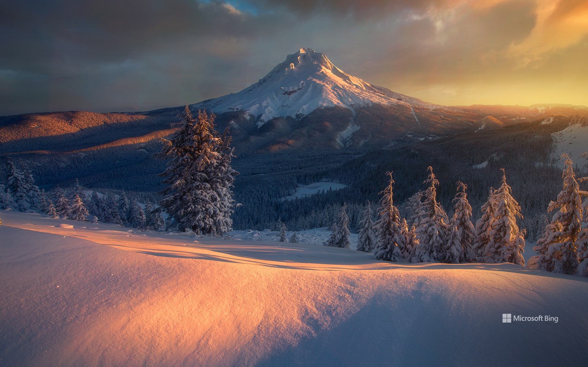
胡德山,俄勒冈州,美国 Mount Hood, Oregon (© Inigo Cia/Getty Images)
沉睡的巨人 A sleeping giant
胡德山,俄勒冈州
胡德山以其白雪皑皑的山尖装点着俄勒冈州的天际线。这座高约11,250英尺的休眠火山是俄勒冈州最高的山,吸引着众多冒险者和自然爱好者前来探险。这里有12座已被命名的冰川以及众多雪原,全年都是“冰雪乐园”。除了有冰雪之美,胡德山还拥有多种多样的生态系统,并孕育了古老的森林,是美洲狮和狼等野生动物的天堂。在过去的1800年里,这座火山喷发过3次。地质学家称,这座火山目前主要处于休眠状态,但仍有可能在将来的某一天再次喷发。
Mount Hood, Oregon
Mount Hood graces Oregon's skyline with a pointed, snow-capped peak. At nearly 11,250 feet high, this dormant stratovolcano is the tallest mountain in the state, drawing adventurers and nature aficionados alike. With 12 named glaciers and numerous snow fields, Mount Hood offers a wintry playground all year round. It also nurtures ancient forests and provides a haven for wildlife, including cougars and wolves. Over the past 1,800 years, the volcano has erupted three times. While considered dormant, there is still a chance that it could erupt one day.
哥伦比亚河上的阿斯托里亚-梅格勒大桥,阿斯托里亚区,俄勒冈州,美国 Astoria-Megler Bridge on the Columbia River, Astoria, Oregon (© Dan Mihai/Getty Images)
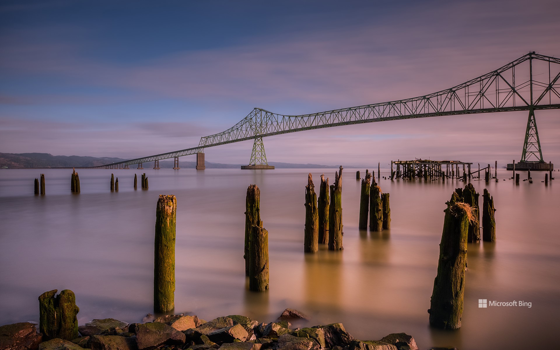
哥伦比亚河上的阿斯托里亚-梅格勒大桥,阿斯托里亚区,俄勒冈州,美国 Astoria-Megler Bridge on the Columbia River, Astoria, Oregon (© Dan Mihai/Getty Images)
一条用桁架架起来的公路 A road you can truss
阿斯托里亚-梅格勒大桥,俄勒冈州
1805年,梅里韦瑟·刘易斯和威廉·克拉克从圣路易斯附近出发,开始了他们传奇的北美探险。穿越平原、山脉和森林,历时近两年,他们最终抵达了这个地方,目之所及是滚滚江水西去的壮阔景象,浩浩荡荡的哥伦比亚河注入太平洋,无边无际的海水一直延伸至地平线。1811年,美国毛皮公司在附近建立了阿斯托里亚堡,这是美国在西海岸的第一个殖民地。155年后,图中的阿斯托里亚-梅格勒大桥竣工通车。这是一座横跨哥伦比亚河的连续桁架桥,101号美国国道从大桥上经过,连接洛杉矶和华盛顿奥林匹亚。来自美国7个州和加拿大2个省的水流经哥伦比亚河,穿过这座全长约21474英尺,北美最长的连续桁架桥。
Astoria-Megler Bridge, Oregon
Imagine traveling for nearly two years across plains, mountains, and forests and finally arriving at this setting, where the mighty Columbia River empties into the Pacific near present-day Astoria, Oregon. That is the sight that greeted explorers Meriwether Lewis and William Clark in 1805 at the culmination of their legendary 8,000-mile North American expedition that originated near St. Louis.
The expedition's success opened the way for further exploration and development of the Pacific Northwest and by 1811, Fort Astoria, the first US-owned settlement on the West Coast, was established. Oregon became the 33rd state in 1859. The Astoria-Megler Bridge opened in 1966, the final piece connecting Los Angeles to Olympia, Washington, via US Route 101.
Water from seven states and two Canadian provinces flows through the Columbia, passing under the 4-mile structure, the longest continuous truss bridge in North America.
约翰迪化石床国家纪念地中的彩绘山,俄勒冈州,美国 The Painted Hills in John Day Fossil Beds National Monument, Oregon (© Ben Herndon/Tandem Stills + Motion)
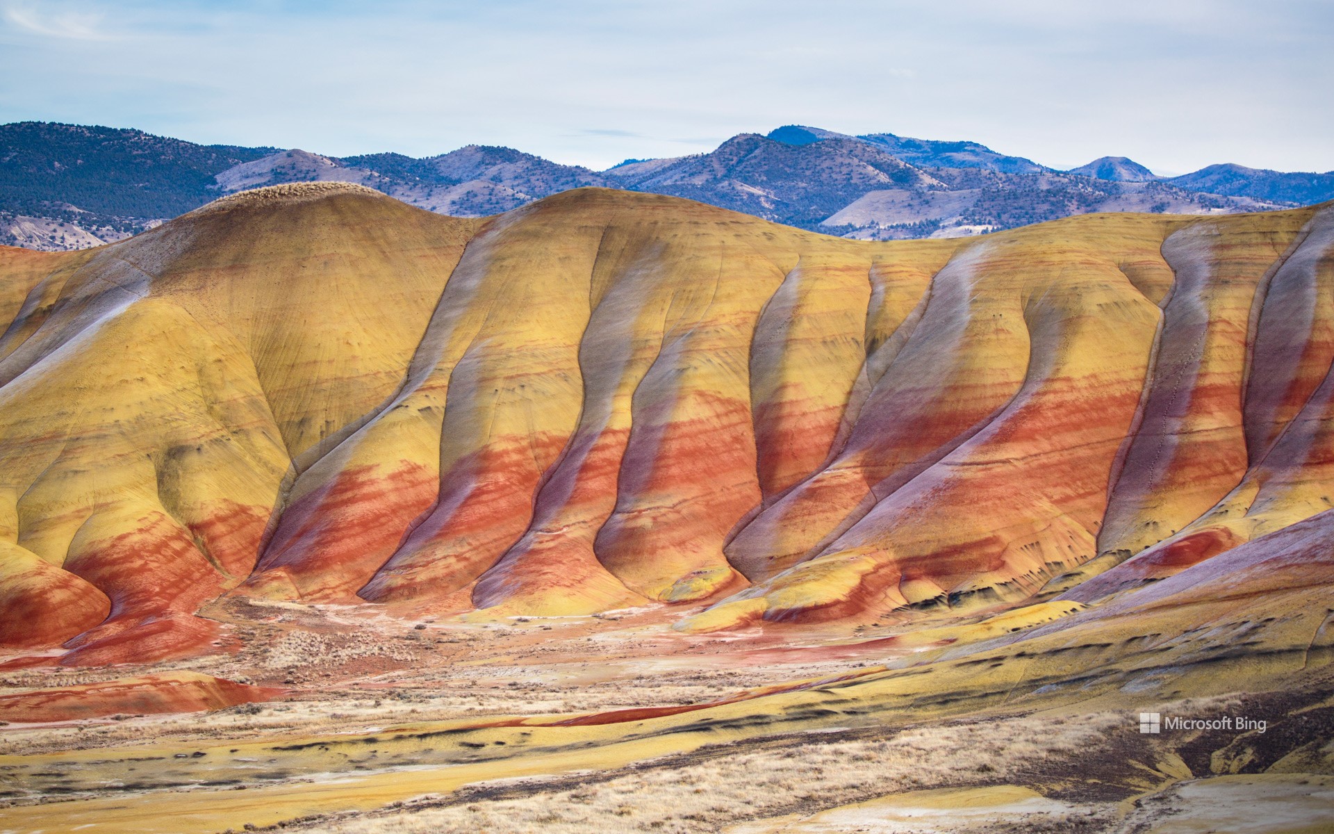
约翰迪化石床国家纪念地中的彩绘山,俄勒冈州,美国 The Painted Hills in John Day Fossil Beds National Monument, Oregon (© Ben Herndon/Tandem Stills + Motion)
消失的回声 Echoes of extinction
彩绘山,俄勒冈州
为了庆祝国际化石日,今天我们一起来了解一下位于俄勒冈州的约翰迪化石床国家纪念地中那迷人的彩绘山。一层层色彩鲜艳又富含粘土的土壤构成了彩绘山迷人的景观。此外,这些山丘还记录了该区域数百年以来的气候和生态系统的变化。在这里,游客们可以自由地参观博物馆内陈列着的动植物化石。在纪念地的克拉诺单元,人们可以一窥负鼠化石、岳齿兽化石、剑齿虎化石和海龟化石的风采,而这些遗迹也在提醒着人们,我们的星球曾活力无限、生机勃勃。
National Fossil Day
For National Fossil Day, we're looking at the mesmerizing Painted Hills, found in the John Day Fossil Beds National Monument in Oregon. Those stripes of red, tan, orange, and black were formed over tens of millions of years, the different layers in the claystone hills reflecting changes in the climate over that period. The monument itself is divided into three units, Painted Hills, Clarno, and Sheep Rock. In the latter, you'll find the Thomas Condon Visitor Center with a paleontology lab and a museum displaying hundreds of fossils. In the fossil beds, the remains of more than 100 species of mammals have been found, including saber-toothed tigers, turtles, and opossums, as well as many fossilized plant species. While the landscape might sometimes look otherworldly, it offers us a peek into Earth's dynamic and fascinating history.
英仙座流星雨,白杨木峡谷州立公园,俄勒冈州,美国 Perseid meteor shower, Cottonwood Canyon State Park, Oregon (© Joshua Meador/Tandem Stills + Motion)
英仙座流星雨,白杨木峡谷州立公园,俄勒冈州,美国 Perseid meteor shower, Cottonwood Canyon State Park, Oregon (© Joshua Meador/Tandem Stills + Motion)
抬头看,它来了 Look up, incoming…
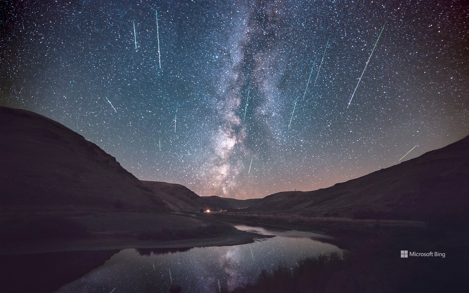
英仙座流星雨
当我们的祖先看到安静的夜空突然下起流星雨,他们会是什么感受?是惊惧还是惊叹?好在现在的我们已经知道,这是一场年度“灯光秀”,被称为英仙座流星雨,活跃期一般在每年的7月中旬至8月下旬。英仙座流星雨是由地球穿过斯威夫特-塔特尔彗星留下的碎片造成的,当这些碎片撞击地球大气层,就会产生炽热的流星雨。今天正是英仙座流星雨的高峰期,月亮预计只有10%的亮度,今晚可千万别错过“赏雨”哦!
Perseid meteor shower over Oregon
What must our ancestors have thought when they saw meteors light up the night sky? Was it terrifying or an event of wonder? Thankfully, we now know that this celestial cascade is a harmless annual event. The Perseid meteor shower thrills stargazers from mid-July to late August and is due to peak today. The Perseids are caused by Earth passing through debris left behind by the Comet Swift-Tuttle. When the cosmic debris hits our atmosphere, it disintegrates in a colorful, fiery light display. It's a good night to catch the Perseids if you can—the moon is projected to only be 10% illuminated, so the meteors should really stand out against the dark sky.
哥伦比亚河峡谷,俄勒冈州,美国 Mossy Grotto Falls, Columbia River Gorge, Oregon (© Chase Dekker Wild-Life Images/Getty Images)
哥伦比亚河峡谷,俄勒冈州,美国 Mossy Grotto Falls, Columbia River Gorge, Oregon (© Chase Dekker Wild-Life Images/Getty Images)
这个隐秘的瀑布在哪里? Where is this hidden waterfall?
哥伦比亚河峡谷的瀑布,俄勒冈州,美国
俄勒冈州的哥伦比亚河峡谷中有大约90个瀑布,苔藓石窟瀑布就是其中一个高20英尺的迷你瀑布。苔藓石窟瀑布于2006年被发现,经由几位著名摄影师而名声大噪。与幽雅清静、潺潺作响的苔藓岩洞瀑布形成鲜明对比的,是世界上最高的瀑布——委内瑞拉的天使瀑布,其落差高达2648英尺,汹涌咆哮的奇观令人惊叹,是委内瑞拉最吸引游客的景点之一。如果你想要放松沉思片刻,建议寻找距离最近的瀑布,然后踏上亲近大自然的旅程吧。
Mossy Grotto Falls, Oregon
Mossy Grotto Falls is a tiny 20-foot waterfall in Oregon's Columbia River Gorge, home to around 90 waterfalls. This winsome waterfall became popular in recent years after several renowned photographers snapped it following its discovery in 2006. Waterfalls around the world draw our attention and inspire emotions (and even themes for pop songs). In contrast to the serene, burbling Mossy Grotto Falls, Angel Falls in Venezuela is the tallest in the world, where water plunges 2,648 feet before reaching the ground. This roaring wonder is awe-inspiring and one of the top tourist-draws in the country. If you need a moment of reflection, we recommend searching for the nearest waterfall and taking a trip to connect with nature.
哈萨塔角灯塔,佛罗伦萨,俄勒冈州 Heceta Head Light, Florence, Oregon (© Tom Schwabel/Tandem Stills + Motion)
哈萨塔角灯塔,佛罗伦萨,俄勒冈州 Heceta Head Light, Florence, Oregon (© Tom Schwabel/Tandem Stills + Motion)
黑夜海岸边的一盏灯 A light in the coastal darkness
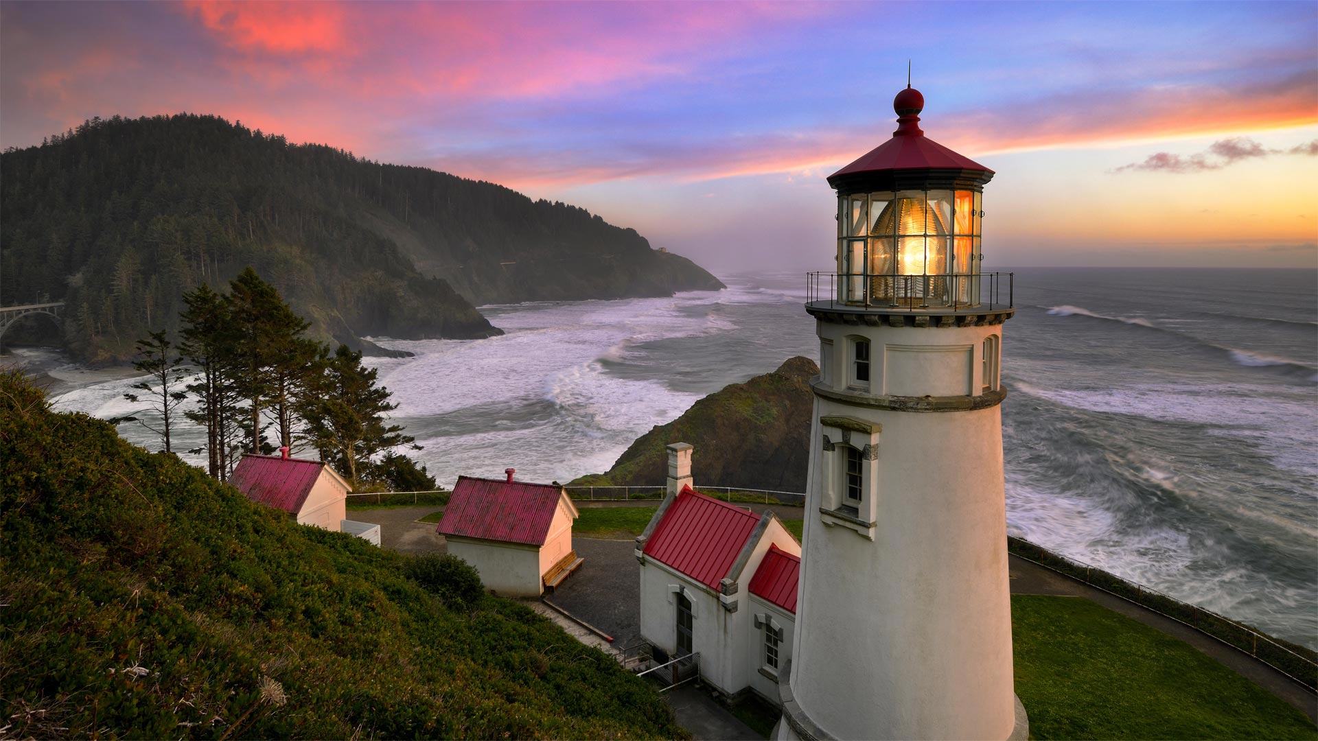
Heceta Head Light, Florence, Oregon
Heceta Head Light is perched 205 feet above the Pacific Ocean on Oregon's central coast. The headland is named for Spanish Basque explorer Don Bruno de Heceta, who led a secret expedition in 1775 to bolster Spain's claim to the Pacific Coast of North America. Having sailed from Mexico, by the time the voyage reached these shores, the crew was ravaged by scurvy and Heceta made the call to turn back—but not before he became the first to map and record a written description of the mouth of the Columbia River as well as this rocky 1,000-foot-high headland that would eventually bear his name. By the 19th century, seafarers making their way up and down the coast made the call for a lighthouse to guide their way. Construction of the 56-foot-tall lighthouse was complicated by the steep bluffs and remote location, but the first light beam pierced through the darkness on March 30, 1894.
The first lightkeepers at Heceta Head found the location too isolated, prompting several of them to leave the job after just a short period. Staffing turnover persisted until the 1930's when nearby Oregon Coast Highway was put into service and the area received electricity. The lighthouse played a minor role in World War II when 75 members of the Coast Guard and their dogs were stationed here to guard the beaches. The lighthouse became fully automated in 1963, and by 1970 the lightkeeper's house entered a new era as a satellite campus for a nearby community college. These days the area is on the National Registry of Historic Places and the lightkeeper's cottages have a new life as rooms of a bed and breakfast.
俄勒冈州佛罗伦萨哈萨塔角灯塔
哈萨塔角灯塔位于俄勒冈州中央海岸的太平洋上空205英尺处。岬角以西班牙巴斯克探险家唐·布鲁诺·德·赫切塔的名字命名,他于1775年领导了一支秘密探险队,以支持西班牙对北美太平洋海岸的主张。从墨西哥启航后,当航程到达这些海岸时,船员们被坏血病蹂躏,赫西塔呼吁掉头,但在他成为第一个绘制并记录哥伦比亚河口以及最终以他的名字命名的1000英尺高岩石岬角的书面描述之前。到了19世纪,在海岸上下航行的海员们呼吁建造灯塔来指引他们的航行。这座56英尺高的灯塔因陡峭的悬崖和偏远的地理位置而变得复杂,但1894年3月30日,第一束光线穿透了黑暗。
赫西塔海德的第一批灯管人员发现该地点过于孤立,促使他们中的几人在很短的时间内离开了工作岗位。人员流动一直持续到20世纪30年代,附近的俄勒冈州海岸公路投入使用,该地区通电。灯塔在第二次世界大战中发挥了次要作用,当时有75名海岸警卫队成员和他们的狗驻扎在这里守卫海滩。灯塔在1963年实现了全自动,到1970年,灯塔作为附近社区学院的卫星校园进入了一个新时代。这些天来,该地区已被列入国家历史遗迹登记册,灯塔的小屋作为一个床和早餐的房间有了新的生活。
日出时的麦克拱岩,俄勒冈南海岸 Mack Arch Rock at sunrise on the southern Oregon coast (© Dennis Frates/Alamy)
日出时的麦克拱岩,俄勒冈南海岸 Mack Arch Rock at sunrise on the southern Oregon coast (© Dennis Frates/Alamy)
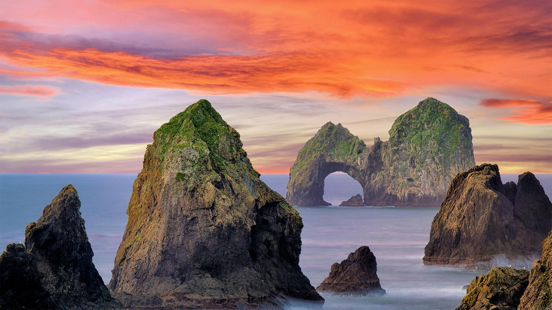
Southern Oregon coast, Mack Arch Rock
One of the common sights along the Oregon coast are the colossal rock formations known as sea stacks that jut from the Pacific and form an indelible, craggy imprint in your memory. The sea stacks you see here run next to a grassy promontory in the southern part of the state that overlooks a mostly inaccessible stretch of coastline.
In the background of this image is the Mack Arch, one of the largest naturally formed arches on the Pacific Coast and part of the Mack Reef archipelago. These clusters of sea stacks and beaches are home to a large concentration of seabirds like cormorants, black oystercatchers, gulls, and murres, as well as harbor seals and other marine wildlife. To help preserve this pristine sanctuary, the US Fish & Wildlife Service has designated it part of the Oregon Islands National Wildlife Refuge and closed the area off to the public. So have the owners of all the privately-owned land and beach that surround the refuge. So, if you're looking to get a close-up view of Mack Arch, your best bet is to do so by plane or boat.
俄勒冈州南部海岸,Mack Arch Rock
俄勒冈州海岸的一个常见景观是巨大的岩层,被称为海垛,它们从太平洋伸出,在你的记忆中形成一个不可磨灭、崎岖不平的印记。你在这里看到的海垛位于该州南部的一个长满青草的海角旁,俯瞰着一段几乎无法到达的海岸线。
这张图片的背景是麦克拱门,它是太平洋海岸最大的自然形成的拱门之一,也是麦克礁群岛的一部分。这些成簇的海垛和海滩是鸬鹚、黑牡蛎捕手、海鸥和海鸥等海鸟以及海豹和其他海洋野生动物的聚集地。为了帮助保护这个原始的保护区,美国鱼类和野生动物服务局已将其指定为俄勒冈群岛国家野生动物保护区的一部分,并对公众关闭了该区域。避难所周围所有私有土地和海滩的所有者也是如此。所以,如果你想近距离观察马克拱门,最好是坐飞机或船。
俄勒冈海岸佩蓓角的雷神之井 Thor's Well at Cape Perpetua on the Oregon coast (© Cavan Images/Offset by Shutterstock)
俄勒冈海岸佩蓓角的雷神之井 Thor's Well at Cape Perpetua on the Oregon coast (© Cavan Images/Offset by Shutterstock)
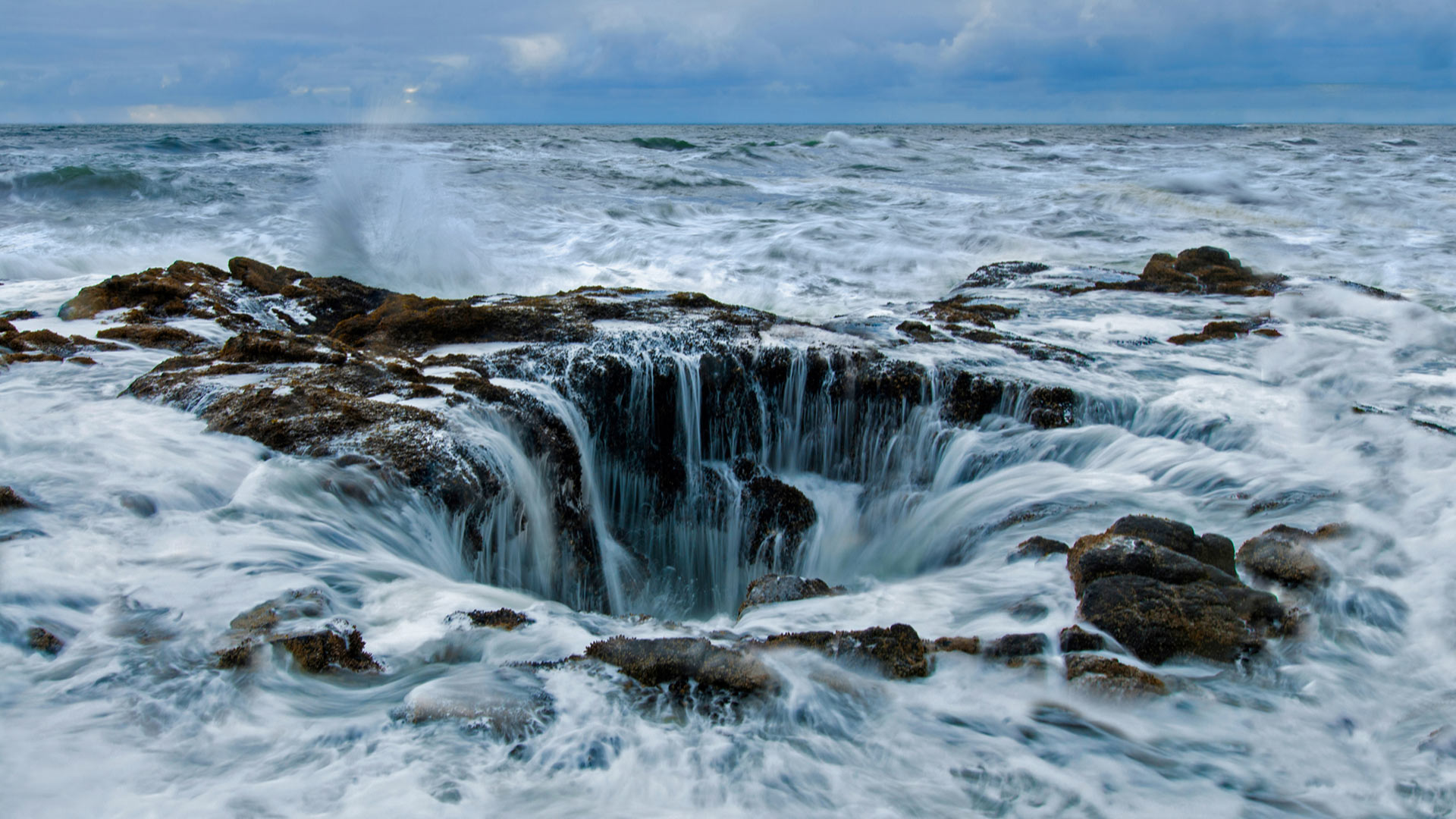
Welcome to the 'drainpipe of the Pacific'
We are standing here on the craggy Oregon coast looking out to Thor's Well with the help of a photographer's telephoto lens. Only the most daring of visitors would stand this close to the gaping sinkhole at high tide. One misstep combined with a forceful surge from the raging Pacific Ocean, and into the plunging well we'd go.
Thor's Well is one of several defining features of Oregon's magical coastline. Dubbed a 'gaping sinkhole,' the 'drainpipe of the Pacific,' and even a 'gate to hell,' it's accessible by foot at low tide, when you can peer in to see its mechanisms at work. Geologists believe it was once a sea cave formed in the basalt rock by ocean waves. The 'well' was formed when the cave's roof collapsed, creating openings at the top and bottom through which the ocean surges and sprays like a geyser, only to recede, creating the waterfalls we see here.
欢迎来到“太平洋排水管”
我们站在俄勒冈州崎岖的海岸上,借助摄影师的长焦镜头向外眺望托尔的水井。只有最勇敢的游客才会在涨潮时站在这么近的大坑里。一次失误,加上汹涌的太平洋汹涌而来的巨浪,我们就进入了我们要去的深井。
托尔水井是俄勒冈州神奇海岸线的几个决定性特征之一。它被称为“张开的深坑”、“太平洋的排水管”,甚至是“地狱之门”,在低潮时你可以步行进入,这时你可以窥视它的运行机制。地质学家认为,这曾经是一个由海浪在玄武岩岩石中形成的海洞。这个“井”是在洞穴的顶部坍塌时形成的,在顶部和底部形成了一个开口,海洋像间歇泉一样涌动和喷涌,最后退去,形成了我们在这里看到的瀑布。
火山口湖,俄勒冈州 Crater Lake in Oregon (© Steve Bloom Images/Alamy)
火山口湖,俄勒冈州 Crater Lake in Oregon (© Steve Bloom Images/Alamy)
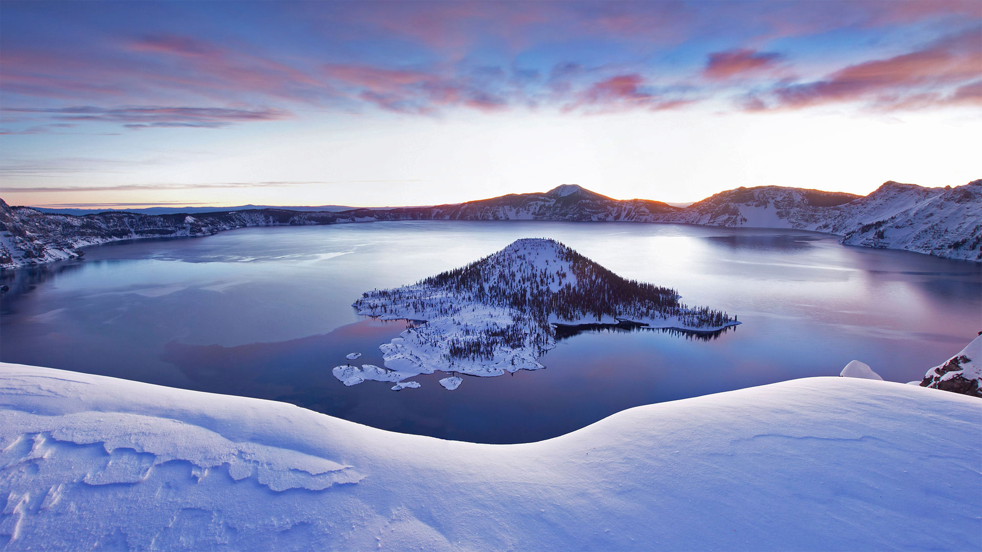
Travels to the Oregon deep
We're looking out on the deepest lake in the US. Crater Lake, the centerpiece and namesake of the only national park in Oregon, goes down to depths of 1,943 feet—that's enough room to stack three-and-a-half Washington Monuments end to end. Fed mainly by snowfall, this pristine, crystal blue lake came into this world with a bang. Sometime around 5700 BCE, Mount Mazama erupted, losing roughly 3,000 feet of its height. The volcano blew out so much molten rock that it left a giant depression that gradually filled with water, giving us this serene scene today.
Crater Lake National Park is open to visitors year-round, but in the winter many of the facilities as well as the road circumventing the lake are closed. But, as our picture captures so beautifully, the snowy view is worth a (socially distant) trip.
前往俄勒冈深处
我们眺望着美国最深的湖泊。火山口湖是俄勒冈州唯一的国家公园的中心和命名地,它的深度达1943英尺,足够将首尾相接的三个半华盛顿纪念碑叠在一起。主要靠降雪,这个原始的水晶般蓝色的湖砰的一声来到了这个世界。大约在公元前5700年左右,马扎马火山爆发,失去了大约3000英尺的高度。火山喷出了大量的熔岩,留下了一个巨大的凹陷,逐渐充满了水,给了我们今天的宁静景象。
火山口湖国家公园全年向游客开放,但在冬季,许多设施以及环湖公路都关闭了。但是,正如我们的照片捕捉到如此美丽,雪景是值得值得一游的。