2022年7月
米尔福德峡湾附近的徒步雨林,新西兰 Rainforest hike near Milford Sound/Piopiotahi in New Zealand (© Jim Patterson/Tandem Stills + Motion)
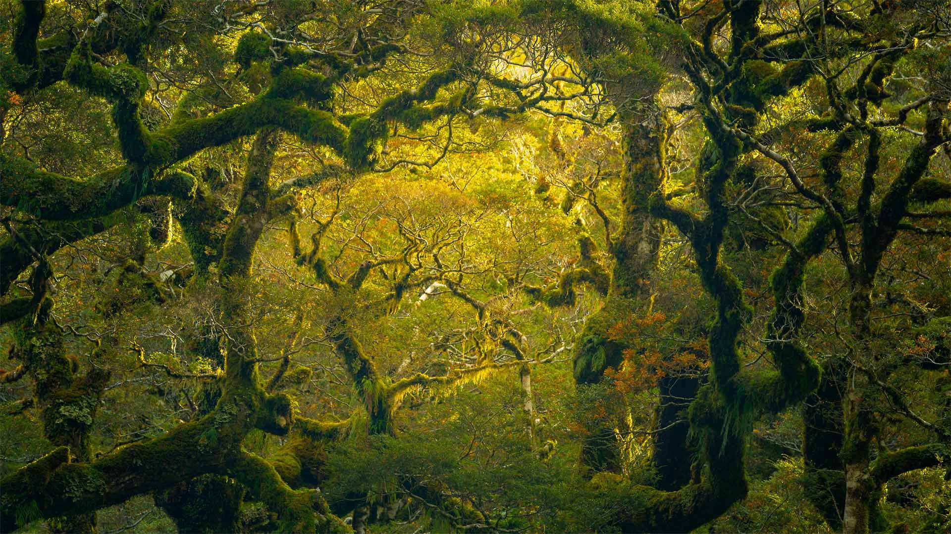
米尔福德峡湾附近的徒步雨林,新西兰 Rainforest hike near Milford Sound/Piopiotahi in New Zealand (© Jim Patterson/Tandem Stills + Motion)
“第八大奇迹”? The ‘eighth wonder'?
Milford Sound/Piopiotahi rainforest in New Zealand
Today we're taking a tramping trip to New Zealand's South Island to visit the place Rudyard Kipling once called the eighth wonder of the world, Milford Sound and its surrounding rainforest. Tramping, New Zealand-speak for hiking, is incredibly popular at Milford Sound. Nearly a million tourists visit the area every year, despite its somewhat remote location. Originally overlooked by European explorers, the area is now known for its beauty and abundance of wildlife. It's not uncommon for visitors to spot dolphins, humpback whales, and native Fiordland penguins.
Since 1998, Milford Sound is one of about 90 places in New Zealand to now officially have a dual name, joining its former European name with the Indigenous Māori name. Now known as Milford Sound / Piopiotahi, the Māori named the area after the extinct piopio bird. According to myth, the Māori hero, Māui, died during his quest to win immortality for mankind. A single piopio flew into the fjord to mourn him. This bird was memorialized in the name, as the Māori word ‘tahi' means ‘one.' The Māori people first traveled to the area centuries ago to hunt and fish. They also collected the precious pounamu (aka greenstone) used for trade, carving, and weaponry.
新西兰米尔福德湾/皮奥皮塔伊雨林
今天,我们将徒步前往新西兰南岛,参观曾经被称为世界第八大奇迹的鲁迪亚德·吉卜林(Rudyard Kipling),米尔福德湾(Milford Sound)及其周围的雨林。“徒步旅行”是新西兰人对徒步旅行的称呼,在米尔福德湾非常受欢迎。尽管该地区有些偏远,但每年仍有近100万游客前来观光。该地区最初被欧洲探险家所忽视,现在以其美丽和丰富的野生动物而闻名。游客看到海豚、座头鲸和本地的峡湾企鹅并不罕见。
自1998年以来,米尔福德湾是新西兰约90个正式拥有双重名称的地方之一,将其前欧洲名称与土著毛利人名称合并。现在被称为米尔福德湾/皮奥皮亚提,毛利人以已灭绝的皮奥皮奥鸟命名该地区。据传说,毛利人英雄毛利在为人类争取永生的过程中去世。一个皮奥飞进峡湾哀悼他。这只鸟以它的名字被纪念,因为毛利人单词“tahi”的意思是“一”几个世纪前,毛利人第一次来到该地区狩猎和捕鱼。他们还收集了珍贵的pounamu(又名绿石),用于贸易、雕刻和武器。
落基山国家公园的朗斯峰,科罗拉多州 Longs Peak in Rocky Mountain National Park, Colorado (© Andrew R. Slaton/Tandem Stills + Motion)
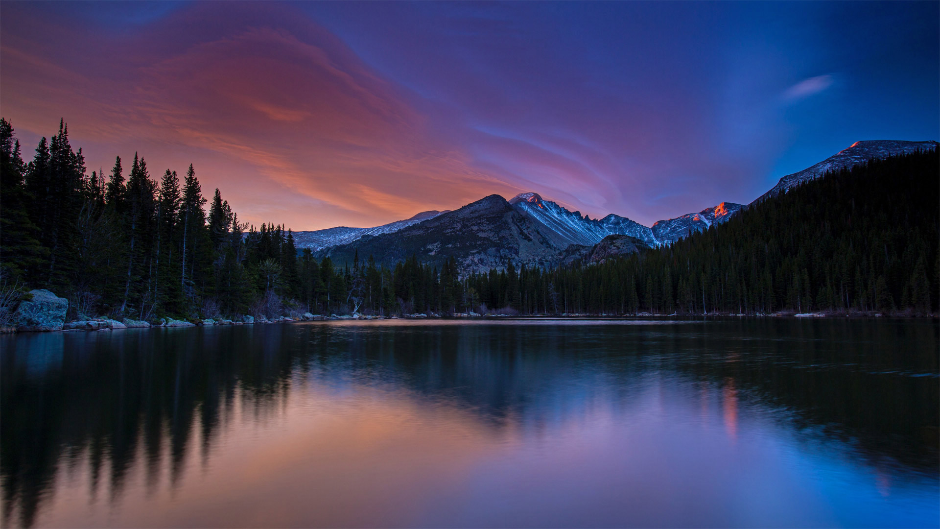
落基山国家公园的朗斯峰,科罗拉多州 Longs Peak in Rocky Mountain National Park, Colorado (© Andrew R. Slaton/Tandem Stills + Motion)
雄伟的紫色山峰 Purple mountain majesties
Longs Peak, Rocky Mountain National Park
One of the 53 'fourteeners' in Colorado—mountains that exceed 14,000 feet—Longs Peak still manages to reach higher into the heavens than any other mountain in Rocky Mountain National Park at 14,259 feet. Thousands of climbers set off every year to attempt the summit. Some climbers will try to reach the peak of every fourteener in the US during their lifetimes—that's 96 different mountains.
Once the home of the Ute and Arapaho peoples, then silver miners and mountain men, today Rocky Mountain National Park teems with outdoor enthusiasts of every stripe. Birdwatchers, bikers, and hikers give way to snowshoers, skiers, and snowboarders as the seasons change. The park if full of wildlife, including nearly seventy kinds of mammals and almost three hundred bird species
落矶山国家公园朗斯峰
科罗拉多山脉有53座“十四座”山峰,其山峰超过14000英尺长,其中一座山峰的海拔仍然比落基山脉国家公园的任何其他山峰都要高,达到14259英尺。每年都有数千名登山者出发尝试登顶。有些登山者会在一生中努力攀登美国每十四座山峰的顶峰,那是96座不同的山峰。
洛基山国家公园曾经是乌特人和阿拉帕霍人的家园,后来是银矿工人和山人的家园,今天这里挤满了各行各业的户外爱好者。随着季节的变化,观鸟者、骑自行车者和徒步旅行者会被雪鞋者、滑雪者和滑雪板者所取代。公园里到处都是野生动物,包括近70种哺乳动物和近300种鸟类
玛甸沙勒(也被称为黑格拉)的纳巴泰墓,沙特阿拉伯 Nabatean tomb in Mada'in Saleh (aka Hegra), Saudi Arabia (© Tuul & Bruno Morandi/Getty Images)
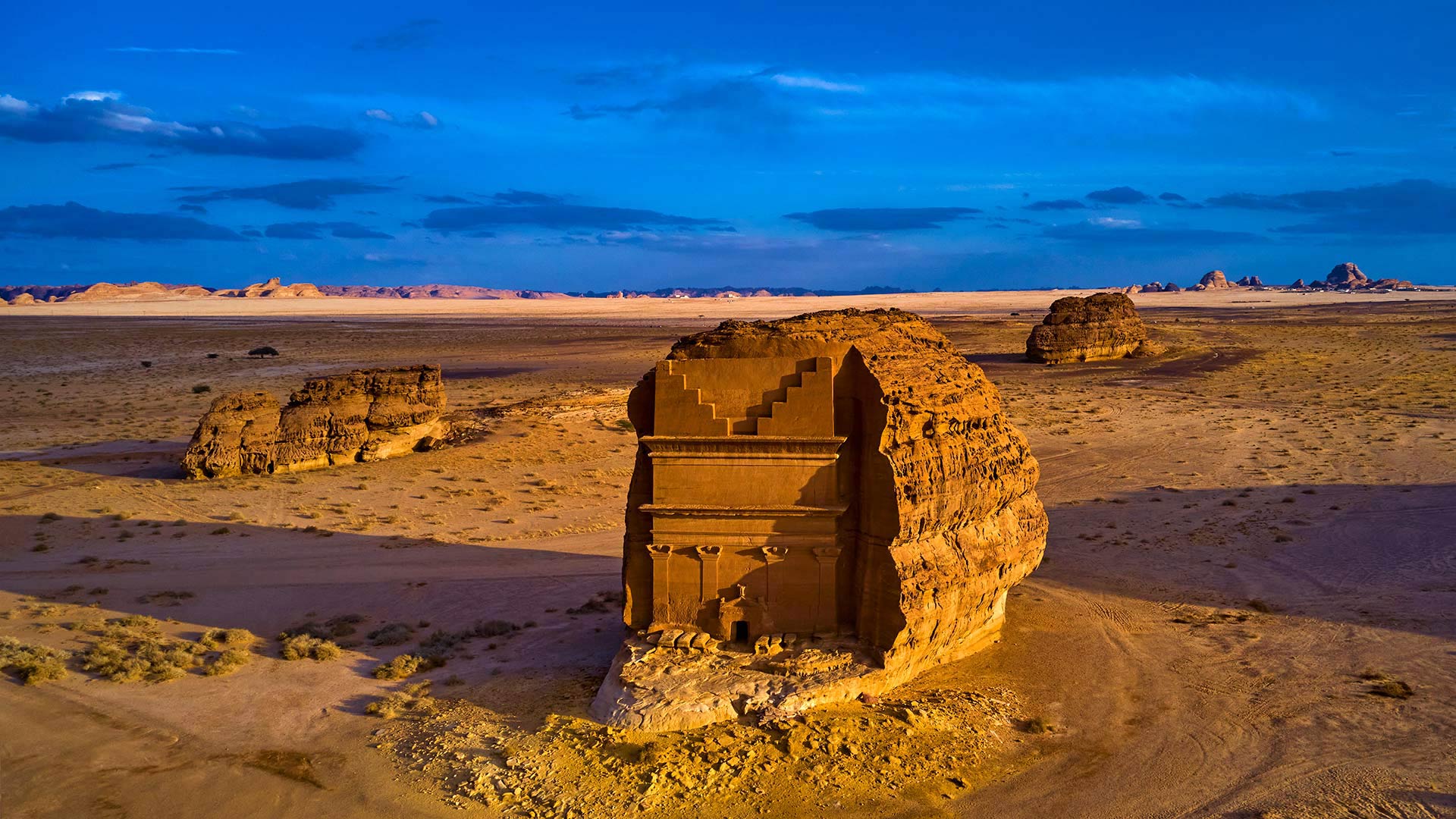
玛甸沙勒(也被称为黑格拉)的纳巴泰墓,沙特阿拉伯 Nabatean tomb in Mada'in Saleh (aka Hegra), Saudi Arabia (© Tuul & Bruno Morandi/Getty Images)
孤独的城堡 The lonely castle
Mada'in Saleh, Saudi Arabia
About 2,000 years ago, Mada'in Saleh, or Hegra as the Romans called it, was a thriving city of the Nabataean Kingdom, and a center for the trade of spices, incense, and myrrh, a valuable tree resin used to make perfume and medicine. The Nabataeans were Arab people whose precise origins are unknown. They lived in northern Arabia and the Southern Levant. Mada'in Saleh was their second-largest and southernmost city after Petra, their capital city to the north. About halfway between Petra and Mecca, Mada'in Saleh served primarily as a trading crossroads and was instrumental in establishing the Nabataeans as prosperous middlemen to the rest of the ancient world.
Today it is one of Saudi Arabia's most celebrated historic treasures, and a UNESCO World Heritage Site, distinguished by more than 100 tombs with ornate facades, carved from sandstone outcroppings on the outskirts of the city. The smallest is less than 10 feet tall, the largest more than 60. Most of the tombs were carved in groups, but this especially embellished monument is relatively isolated, which is why today it's known as the Qasr al-Farid (the Lonely Castle). Here in this windswept desert the bustle of merchants and the caravans full of spices are long gone, but these hand-carved boulders rising abruptly out of the landscape remain as evidence of a time when all roads led to Hegra.
沙特阿拉伯Mada'in Saleh
大约2000年前,马丹·萨利赫(Mada'in Saleh)或罗马人所称的赫格拉(Hegra),是纳巴坦王国的一个繁荣城市,也是香料、香料和没药(一种用于制造香水和药物的贵重树脂)的贸易中心。纳巴塔人是阿拉伯人,其确切起源尚不清楚。他们住在阿拉伯北部和黎凡特南部。马丹·萨利赫是他们的第二大也是最南端的城市,仅次于北部的首都佩特拉。大约在佩特拉和麦加之间的半路上,马丹·萨利赫主要充当贸易十字路口,并帮助纳巴塔人成为通往古代世界其他地区的繁荣中间人。
今天,它是沙特阿拉伯最著名的历史珍宝之一,也是联合国教科文组织世界遗产地,以100多座陵墓为特色,这些陵墓的正面装饰华丽,由城市郊区露出地面的砂岩雕刻而成。最小的不到10英尺高,最大的不到60英尺高。大多数坟墓都是成组雕刻的,但这座特别装饰的纪念碑相对孤立,这就是为什么今天它被称为卡斯尔·法里德(Qasr al-Farid,孤独城堡)。在这片狂风肆虐的沙漠中,商人的喧嚣和装满香料的商队早已消失,但这些手工雕刻的巨石从景观中突然升起,仍然是所有道路通往赫格拉的证据。
萨卢姆三角洲国家公园的红树林,塞内加尔共和国 Mangrove forest in the Saloum Delta National Park, Senegal (© mariusz_prusaczyk/Getty Images)
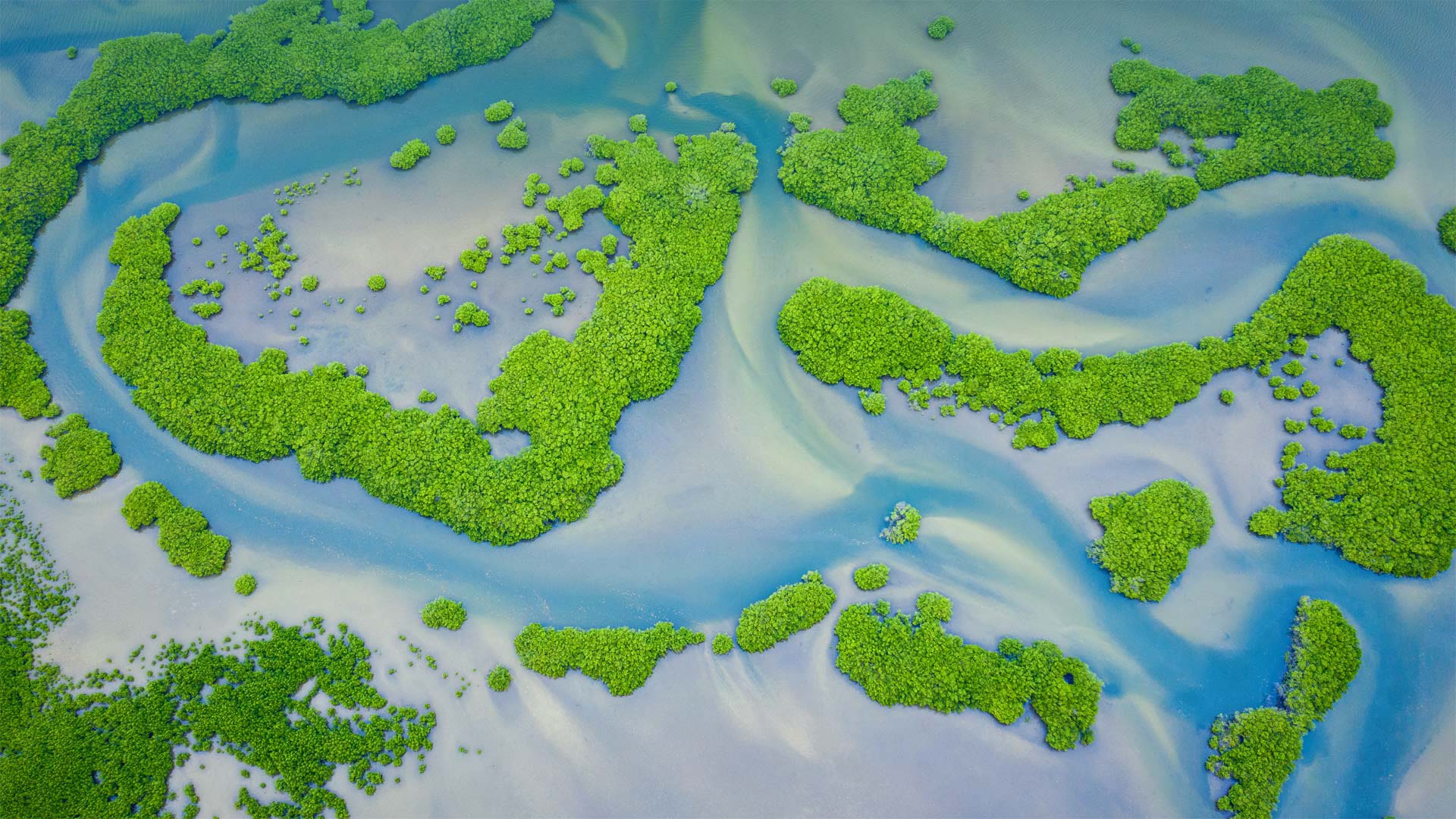
萨卢姆三角洲国家公园的红树林,塞内加尔共和国 Mangrove forest in the Saloum Delta National Park, Senegal (© mariusz_prusaczyk/Getty Images)
被人类遗忘的森林 Our forgotten forests
Mangrove Conservation Day
Although we think of forests as trees on land, some of the most important trees grow in water, or more precisely marshland. Mangrove forests, like this one in Saloum Delta National Park in Senegal, are vital components of the world's coastal ecosystems. Mangroves survive where no other trees can, in salty, low-oxygen coastal waters exposed to tides and storms. They grow up to 30 feet high primarily in tropical and subtropical regions and are able to store vast amounts of carbon, making them crucial to moderating our climate. Mangroves also act as nurseries for fish and aquatic life. And with their complex interwoven root system, they protect coastlines from erosion. Today we join the UN in shining a light on the necessity and fragility of mangroves: July 26 is the International Day for the Conservation of the Mangrove Ecosystem.
The Saloum Delta is part of a UNESCO World Heritage Site, and a sterling example of the biodiversity of marshlands. These shallow, brackish channels contain about 200 islands and islets and support all kinds of marine life and birds. Dolphins and caimans swim in its creeks. Monkeys, warthogs, buffaloes, rhinos, and giraffes roam the savanna farther inland. The park biosphere includes salt flats, estuaries, and of course mangrove forests. Humans have also long inhabited this delta, fishing its waters and cultivating shellfish from giant mounds. For as long as 2,500 years, people have flourished off the bounty of this delta, a bounty made possible by the sturdy mangrove, the bedrock for these marshes, and the keepers of our coastlines.
红树林保护日
虽然我们认为森林是陆地上的树木,但一些最重要的树木生长在水中,或者更准确地说是沼泽地。红树林,比如塞内加尔萨卢姆三角洲国家公园的红树林,是世界沿海生态系统的重要组成部分。在暴露于潮汐和风暴的咸水、低氧海岸水域,红树林在其他树木无法生存的地方生存。它们主要在热带和亚热带地区生长到30英尺高,能够储存大量的碳,这对调节我们的气候至关重要。红树林也是鱼类和水生生物的苗圃。它们复杂的根系交织在一起,保护海岸线免受侵蚀。今天,我们加入联合国,共同关注红树林的必要性和脆弱性:7月26日是国际红树林生态系统保护日。
萨鲁姆三角洲是联合国教科文组织世界遗产地的一部分,也是沼泽地生物多样性的典型代表。这些浅微咸水水道包含约200个岛屿和小岛,支持各种海洋生物和鸟类。海豚和凯门鳄在小溪里游泳。猴子、疣猪、水牛、犀牛和长颈鹿在更远的内陆草原上漫游。公园生物圈包括盐滩、河口,当然还有红树林。人类也长期居住在这个三角洲,在其水域捕鱼,并在巨大的土堆中养殖贝类。长达2500年的时间里,人们靠着这片三角洲的富饶而繁衍生息,这片富饶的土地是由坚固的红树林、这些沼泽的基岩和我们海岸线的守护者所促成的。
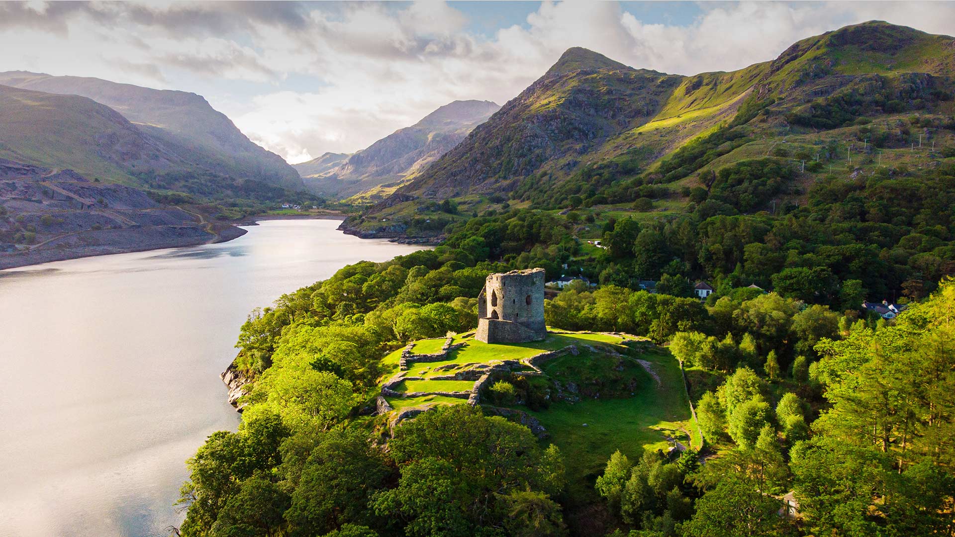
兰贝里斯山口脚下的多尔巴达恩城堡,威尔士 (© Viktoria Rodriguez/Getty Images)
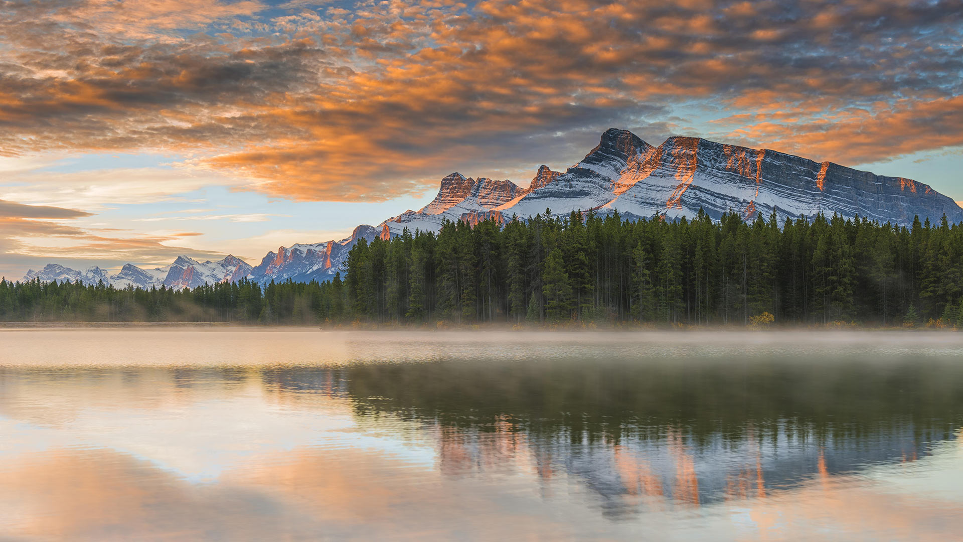
双杰克湖,班夫国家公园,艾伯塔省,加拿大 (© SnapRapid/Offset)
科托尔湾的圣乔治海峡和圣母湾,黑山 Saint George Island and Our Lady of the Rocks in the Bay of Kotor, Perast, Montenegro (© Dmitrii Sakharov/Shutterstock)
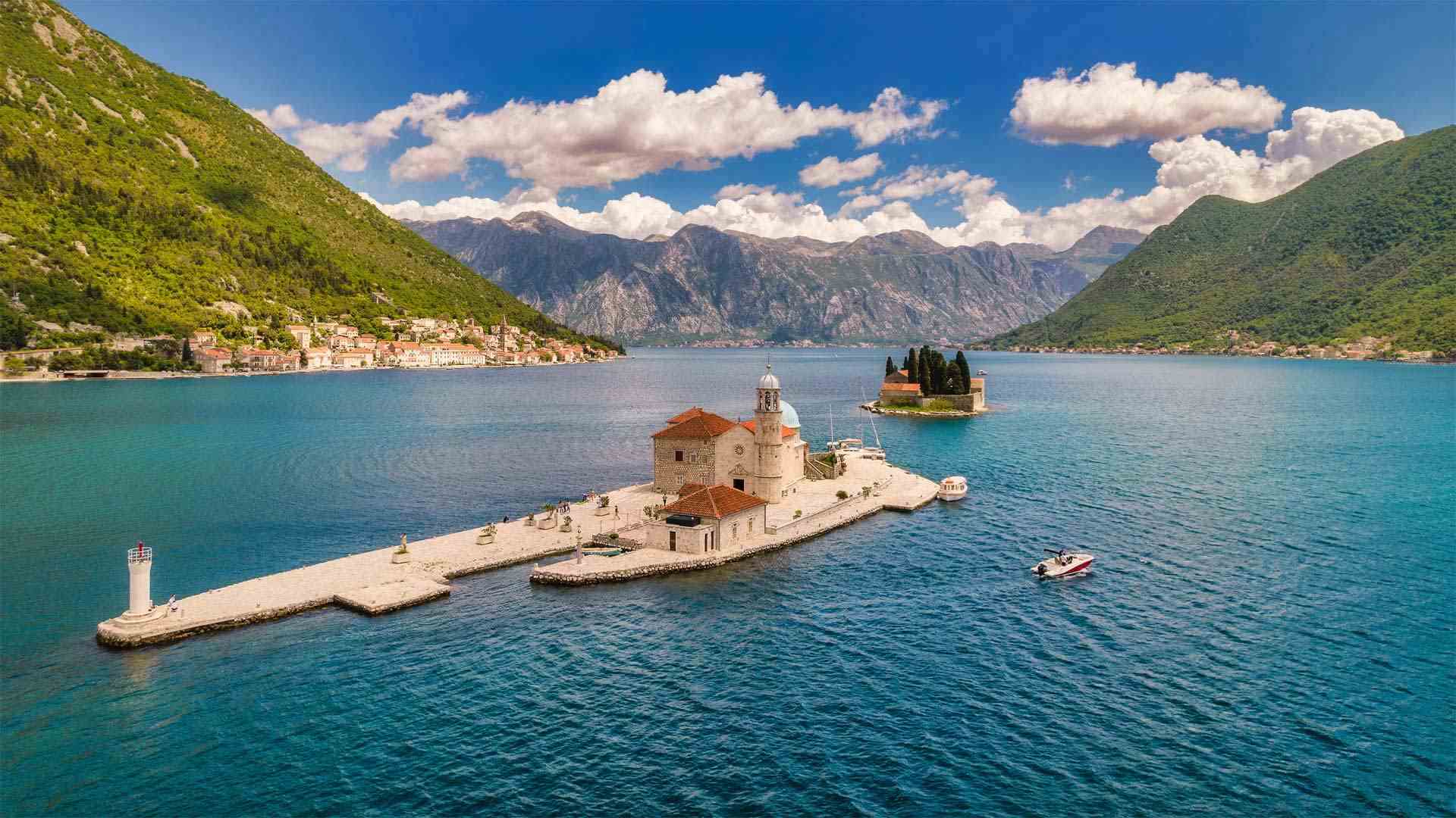
科托尔湾的圣乔治海峡和圣母湾,黑山 Saint George Island and Our Lady of the Rocks in the Bay of Kotor, Perast, Montenegro (© Dmitrii Sakharov/Shutterstock)
用誓言打造的岛屿 An island made from a vow
Our Lady of the Rocks
Local legend here in Perast, Montenegro, has it that two brothers were returning from a dangerous sea voyage in 1452 when they spotted an icon of the Virgin Mary and Child in the waters near Saint George, a natural island in the Bay of Kotor. One of the brothers had injured his leg on the journey, but in the morning it had healed. Taking this as an omen, they vowed to honor the Virgin Mary by building her a church on the spot where they'd spotted the icon. They began dropping stones there, and even scuttling old ships. A tradition was born, and over decades, the fishermen of Perast would drop a stone in the water at that spot before heading to sea.
Over time an island rose out of the bay and a church was erected on it. The centuries since have seen tumult, war, pirate attacks, and at least one devastating earthquake, but Our Lady of the Rocks still stands. The tiny isle continues to grow, as each summer on the evening of July 22, the town celebrates Fašinada, a ritual procession of barges and boats that take more stones to Our Lady of the Rocks. The church is decorated with 68 frescos by local artist Tripo Kokolja (1661-1713) and boasts more than 2,500 silver votives donated by locals.
我们的岩石女神
黑山佩拉斯特当地的传说是,1452年,兄弟俩在一次危险的海上航行后回来,在科托湾的一个天然岛屿圣乔治附近的水域发现了圣母玛利亚和圣婴的肖像。兄弟俩中的一个在旅途中伤了腿,但到了早上,腿就好了。他们以此为预兆,发誓要在发现圣母玛利亚的地方修建一座教堂,以此来纪念圣母玛利亚。他们开始在那里扔石头,甚至撞毁旧船。一个传统诞生了,几十年来,佩拉斯特的渔民在出海之前会在那里的水里扔一块石头。
随着时间的推移,一座岛屿从海湾中升起,并在其上建造了一座教堂。几个世纪以来,动乱、战争、海盗袭击,以及至少一次毁灭性的地震,但我们的岩石之母仍然屹立不倒。这个小岛还在继续发展,因为每年夏天的7月22日晚上,该镇都会庆祝法西纳达,这是驳船和船只的仪式游行,他们会把更多的石头运到我们的岩石之母那里。教堂装饰有68幅由当地艺术家特里波·科科亚(1661-1713)创作的壁画,并拥有2500多幅由当地人捐赠的银质作品。
伯里圣埃德蒙兹镇的修道院公园,英国萨福克郡 Abbey Gardens in Bury St Edmunds, Suffolk, England (© Charles Martinez/Amazing Aerial Agency)
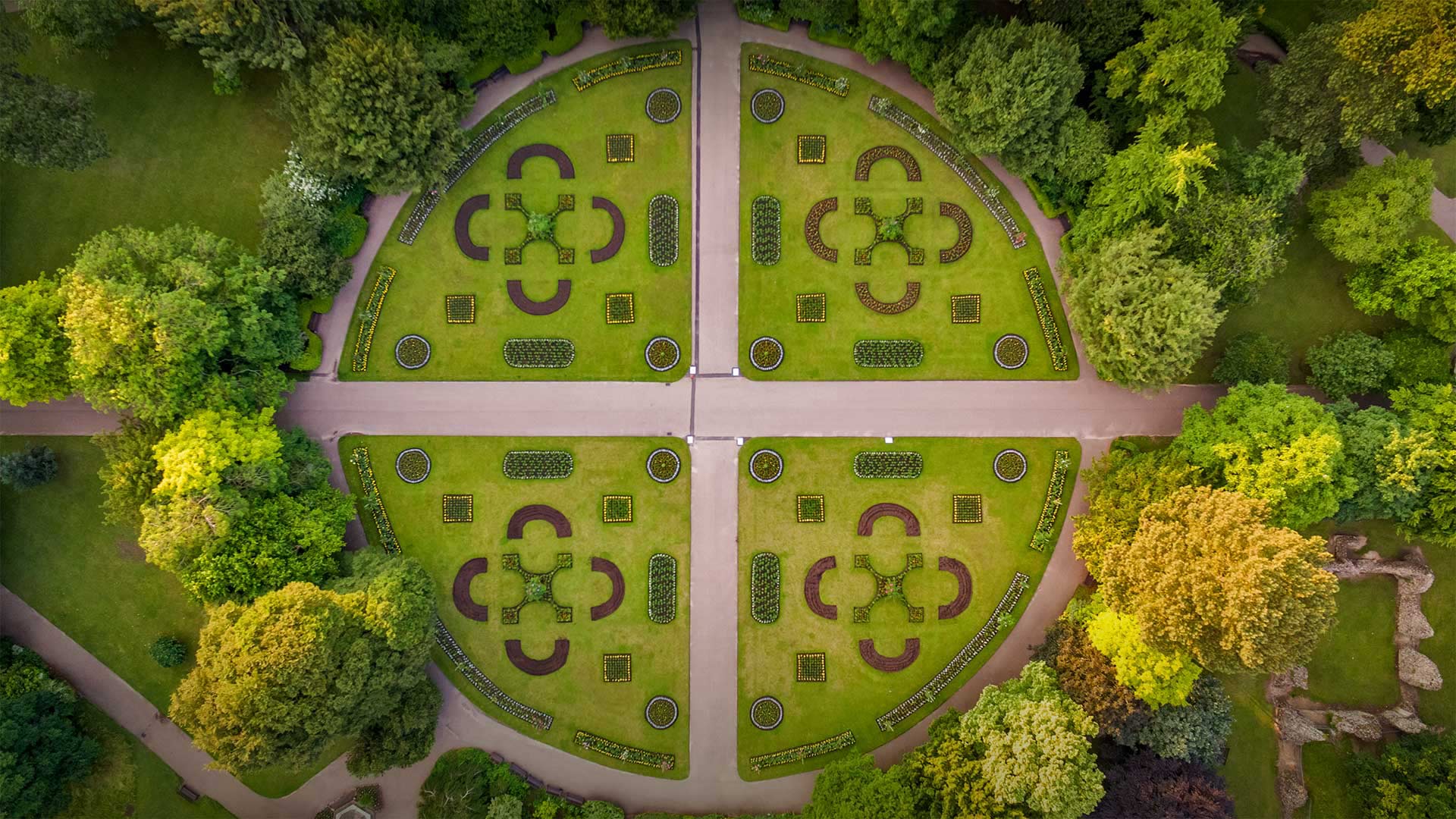
伯里圣埃德蒙兹镇的修道院公园,英国萨福克郡 Abbey Gardens in Bury St Edmunds, Suffolk, England (© Charles Martinez/Amazing Aerial Agency)
绝妙的对称性 Stunning symmetry
Abbey Gardens in Bury St Edmunds, England
Abbey Gardens in Bury St Edmunds comprise a living, vibrant park, and just not because of their 14 acres of colorful displays and ornate flowerbeds—they have changed with the times, all while still jealously guarding their history. The site here in the county of Suffolk, in eastern England, was originally home to a powerful Benedictine Abbey in medieval times—in fact, 2022 marks the 1000th anniversary of the storied abbey. You can still visit the abbey ruins and marvel at the 14th-century Great Gate and Norman Tower, which have survived through the ages. Nathaniel Hodson took the original Abbey Gardens and designed them as a botanic garden in 1831, using the Royal Botanic Gardens in Brussels, with its concentric circles, as his inspiration.
A century later, the people of Bury St Edmunds saw the popular park's circular beds replaced by 64 island beds in honor of George VI's coronation, which they celebrated in 1937, all set off by specially designed illuminations. A water garden and rose garden added more dimensions to the park, followed by an herb garden (the monks of yesteryear would be happy) and a sensory garden for the visually impaired. Today, gardeners plant about 20,000 plants in the spring to dazzle summer visitors, and then they do the same with 12,000 plants and 20,000 bulbs each fall in anticipation of a colorful display the next spring.
英国伯里圣埃德蒙修道院花园
伯里圣埃德蒙的修道院花园是一个充满活力的公园,但这并不是因为它们14英亩的彩色展示和华丽的花坛,它们随着时代的变化而变化,同时仍在嫉妒地守护着它们的历史。该遗址位于英格兰东部萨福克郡,中世纪时曾是一座强大的本笃会修道院的所在地。事实上,2022年是这座历史悠久的修道院的1000周年纪念日。你仍然可以参观修道院遗址,并惊叹于14世纪的大门和诺曼塔,它们历久弥新。1831年,纳撒尼尔·霍德森(Nathaniel Hodson)以布鲁塞尔皇家植物园(Royal botanic Gardens)及其同心圆为灵感,将修道院最初的花园设计为植物园。
一个世纪后,伯里圣埃德蒙兹的人们看到了受欢迎的公园的圆形床被64张岛屿床所取代,以纪念乔治六世的加冕典礼,他们在1937年庆祝了加冕典礼,所有这些都由专门设计的照明装置所衬托。一个水上花园和玫瑰园为公园增加了更多的空间,接着是一个草本花园(去年的僧侣们会很高兴)和一个视觉障碍者的感官花园。如今,园丁们在春季种植了约20000株植物,以吸引夏季游客的眼球,然后他们每年秋天都会种植12000株植物和20000株鳞茎植物,以期待来年春天的多彩展示。
一组月相照片 Composite photo showing the phases of the moon (© Delpixart/Getty Images)
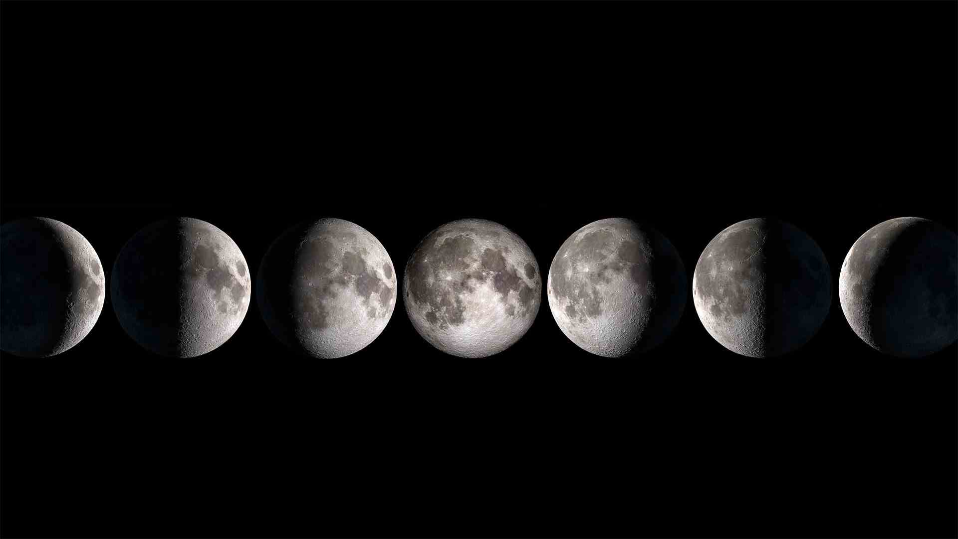
一组月相照片 Composite photo showing the phases of the moon (© Delpixart/Getty Images)
人类迈出的一大步 One giant leap for mankind
National Moon Day
Bigger and brighter than anything else you can see from Earth in the night sky, the moon has inspired our calendar, our songs, our art, our stories, and our dreams. Today, on National Moon Day, we remember one dream that came true on this date in 1969: the day humans first set foot on the lunar surface. So far, it's the only place beyond our planet that humans have visited.
Fifty-three years ago, millions of people around the world watched NASA astronaut Neil Armstrong step out of the Apollo Lunar Module Eagle and onto the surface of the moon. Fellow astronaut Buzz Aldrin followed him 19 minutes later, and the pair spent more than two hours exploring the landing site and collecting samples of lunar material. They and a third astronaut, Michael Collins—who flew the command module that took them back to Earth and did not have a moon walk of his own—spent eight days in space before splashing down in the Pacific Ocean. The moon landing gave the US a victory in the Space Race with the Soviets.
The moon is Earth's only natural satellite, orbiting our planet about every 28 days, what we refer to as a lunar cycle. The moon has virtually no atmosphere, no evidence of life, no water, no sound, and very low gravity. It is literally a dusty ball of rock. Yet, the moon stabilizes Earth's wobble on its axis and therefore moderates our climate. Most scientists believe it was formed out of debris ejected from Earth after a massive collision with another planet-like body. If that's true, the moon is part of Earth, inextricably linked forever.
国家月球日
月亮比你在夜空中从地球上看到的任何东西都更大、更明亮,它激发了我们的日历、我们的歌曲、我们的艺术、我们的故事和我们的梦想。今天,在国家月球日,我们记得1969年这个日子实现的一个梦想:人类首次踏上月球表面的那一天。到目前为止,它是地球之外唯一一个人类去过的地方。
五十三年前,全世界数百万人观看了美国宇航局宇航员尼尔·阿姆斯特朗走出阿波罗登月舱“鹰”登上月球表面。19分钟后,另一名宇航员巴兹·奥尔德林跟随他,两人花了两个多小时探索着陆点并收集月球物质样本。他们和第三名宇航员迈克尔·柯林斯(Michael Collins)在太空中度过了八天,然后坠入太平洋。迈克尔·柯林斯驾驶着指挥舱将他们带回了地球,他自己也没有进行过月球行走。登月使美国在与苏联的太空竞赛中取得了胜利。
月球是地球上唯一的天然卫星,大约每28天绕地球一周,我们称之为月球周期。月球几乎没有大气层,没有生命迹象,没有水,没有声音,重力很低。它实际上是一个尘土飞扬的岩石球。然而,月球稳定了地球在其轴线上的摆动,因此缓和了我们的气候。大多数科学家认为,它是由与另一个类似行星的物体发生大规模碰撞后从地球上喷出的碎片形成的。如果这是真的,那么月球是地球的一部分,永远是密不可分的。
基姆湖上的淑女岛,德国巴伐利亚州 Aerial view of Fraueninsel island in Chiemsee, Bavaria, Germany (© Malorny/Getty Images)

基姆湖上的淑女岛,德国巴伐利亚州 Aerial view of Fraueninsel island in Chiemsee, Bavaria, Germany (© Malorny/Getty Images)
“巴伐利亚海”中的岛屿 Island in the "Bavarian Sea"
Fraueninsel, Chiemsee, Bayern
Just 15.5 hectares in size, the Fraueninsel is still the second-largest island in the Chiemsee after the Herreninsel - admittedly, there are only three inland islands in total, and the tiny Krautinsel as the third in the group is also uninhabited. The car-free Fraueninsel, whose appearance is mainly characterized by the Benedictine monastery of Frauenchiemsee (also known as Frauenwörth), founded in 782, can be reached all year round with the passenger ships of the Chiemsee shipping company.
The only settlement on the Fraueninsel is called Frauenchiemsee. It consists of about 50 houses in which around 250 people live. The name of the place and the island are often used synonymously. Chiemsee, which covers almost 80 square kilometers, is Bavaria's largest lake and Germany's third-largest after Lake Constance and Müritz. In the absence of its own seashore, an affectionate nickname for Lake Chiemsee has emerged among the Bavarian population over time: it is very often referred to as the "Bavarian Sea".
Fraueninsel、切姆西、拜仁
面积只有15.5公顷的弗劳尼塞尔岛仍然是基姆塞岛上仅次于赫雷宁塞尔岛的第二大岛屿——不可否认,总共只有三个内陆岛屿,而作为该群岛第三大岛屿的小克劳蒂塞尔岛也无人居住。无车Fraueninsel的外观主要以建于782年的Frauenchiemsee(也称为Frauenwörth)本笃会修道院为特征,可以通过Chiemsee航运公司的客船全年到达。
关于Fraueninsel的唯一解决方案称为Frauenchiemsee。它由大约50座房屋组成,其中约有250人居住。这个地方和这个岛的名字通常是同义词。基姆塞湖占地近80平方公里,是巴伐利亚州最大的湖泊,也是德国仅次于康斯坦斯湖和缪里兹湖的第三大湖。由于没有自己的海岸,随着时间的推移,基姆塞湖在巴伐利亚人中出现了一个亲切的昵称:它通常被称为“巴伐利亚海”。