标签 美国 下的文章
华盛顿州北瀑布国家公园,美国 North Cascades National Park, Washington (© Ethan Welty/Tandem Stills + Motion)
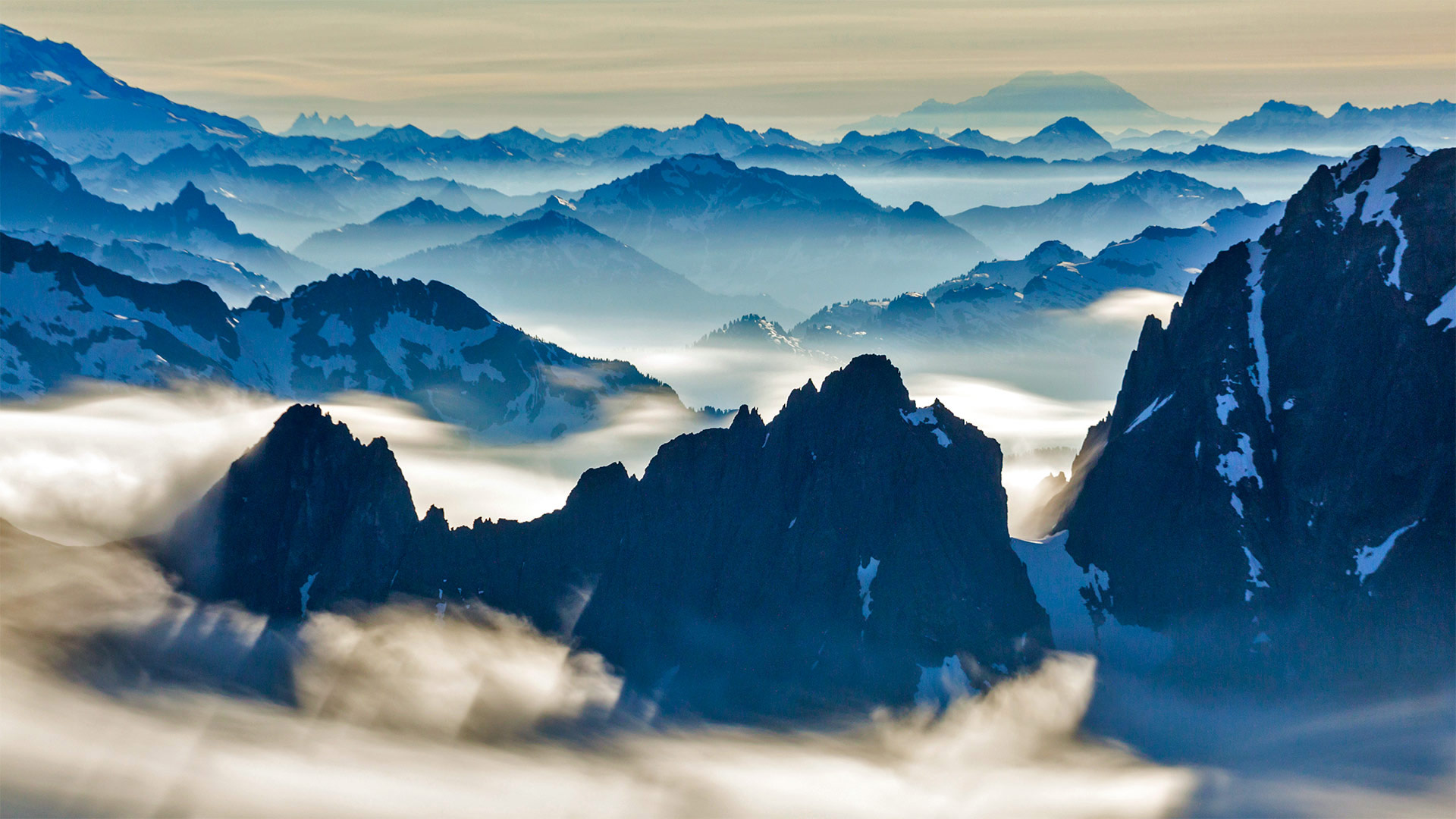
华盛顿州北瀑布国家公园,美国 North Cascades National Park, Washington (© Ethan Welty/Tandem Stills + Motion)
令人惊叹的后花园 Amazing backyard
North Cascades National Park
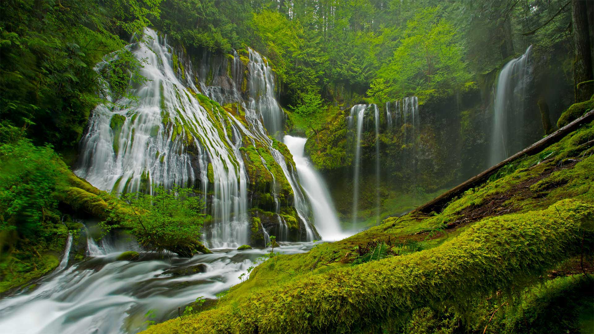
North Cascades is one of three national parks in Washington state (the others are Olympic and Mount Rainier). North Cascades is also the state's newest national park, created in 1968. It is perhaps the most rugged park in the lower 48 states, containing more than 500,000 acres of steep mountain peaks, vast forests, as well as the headwaters of many waterways. It boasts the most expansive system of glaciers in the US outside of Alaska. Most of the park is protected as wilderness so there are few roads, structures, or signs of human impact. It is relatively isolated even though it's within 100 miles (as the crow flies) from the metropolises of Seattle and Vancouver, Canada. This proximity of wilderness to human development reminds us why we created the NPS, to preserve some of the nation's most special places in their natural state.
北瀑布国家公园
北瀑布是华盛顿州的三个国家公园之一(其他两个是奥林匹克公园和雷尼尔山公园)。北喀斯特也是该州最新的国家公园,创建于1968年。它可能是48个州中最崎岖的公园,拥有50多万英亩陡峭的山峰、广阔的森林以及许多水道的源头。它拥有阿拉斯加以外美国最广阔的冰川系统。公园的大部分被保护为荒野,因此几乎没有道路、结构或人类影响的迹象。尽管它距离西雅图和加拿大温哥华的大都市不到100英里(就像乌鸦一样),但它还是相对孤立。荒野与人类发展的这种接近提醒我们,为什么我们创建了自然保护区,以保护国家一些最特殊的自然状态。
夕阳下的大白鲨过山车,美国新泽西州 The Great White Roller Coaster at Wildwood, New Jersey (© John Van Decker/Alamy)
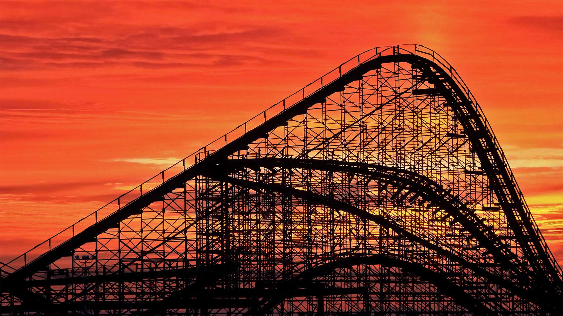
夕阳下的大白鲨过山车,美国新泽西州 The Great White Roller Coaster at Wildwood, New Jersey (© John Van Decker/Alamy)
惊险之旅 Thrill ride
The Great White Roller Coaster
To really get the feel for today's photo, stop what you're doing, put your hands in the air, and imagine yourself plunging downhill at 50 miles an hour. Screaming is optional. We're waiting in line at Morey's Piers in Wildwood, New Jersey, for our ride on The Great White. A hybrid wooden and steel coaster, it's been in operation since 1996 and reaches its highest point 110 feet above the ground. Coaster enthusiasts point out the ride's dip under the pier shortly after the start as one of its highlights. It's also noted for a portion of the ride swinging out over the nearby beach.
Roller coasters have come a long way since their early days beginning in the 17th century as Russian sled rides. Eventually called Russian Mountains, those original rides were just tall, wooden ramps covered in ice. When the concept made its way to much warmer France, the sleds made their way across the tracks on wooden rollers, hence the name 'roller coasters.' Coasters saw another advancement in the 1800s when a Pennsylvania mining company built a downhill gravity railroad to transport coal. Its train cars held double duty by giving thrill rides to tourists during downtime. By 1919, coasters had entered their 'golden age' with fully formed rides all over the world. The desire to experience greater heights and faster drops mean the sky's the limit when it comes to coaster design. These days, in the United States alone, thrill seekers take roughly 1.7 billion rides per year across more than 800 coasters.
大白色过山车
为了真正了解今天的照片,停止你正在做的事情,把手举到空中,想象你以每小时50英里的速度下山。尖叫是可选的。我们在新泽西州Wildwood的Morey‘s Piers排队等候乘坐大白鲨。这是一款木制和钢制的混合过山车,自1996年起投入使用,最高点离地110英尺。过山车爱好者指出,在出发后不久,过山车在码头下的下沉是其亮点之一。它还以一部分骑行在附近的海滩上摇摆而闻名。
过山车从17世纪开始作为俄罗斯雪橇运动以来已经走过了漫长的道路。这些最初的游乐设施最终被称为俄罗斯山脉,它们只是覆盖着冰的高大木质坡道。当这个概念传播到气候暖和得多的法国时,雪橇在木制滚轮上穿过轨道,因此得名“过山车”19世纪,当宾夕法尼亚州的一家矿业公司建造了一条下坡重力铁路来运输煤炭时,过山车迎来了另一个进步。它的火车车厢承担着双重职责,在停工期间为游客提供惊险刺激的乘坐体验。到1919年,云霄飞车已进入其“黄金时代”,全世界都有完整的云霄飞行设施。想要体验更高的高度和更快的下降速度,这意味着在过山车设计方面,天空是极限。如今,仅在美国一地,寻求刺激的人每年就要乘坐超过800辆过山车,约17亿次。
圆顶礁国家公园里的希克曼桥,美国犹他州 The Hickman Bridge at Capitol Reef National Park, Utah (© Tim Fitzharris/Minden Pictures)
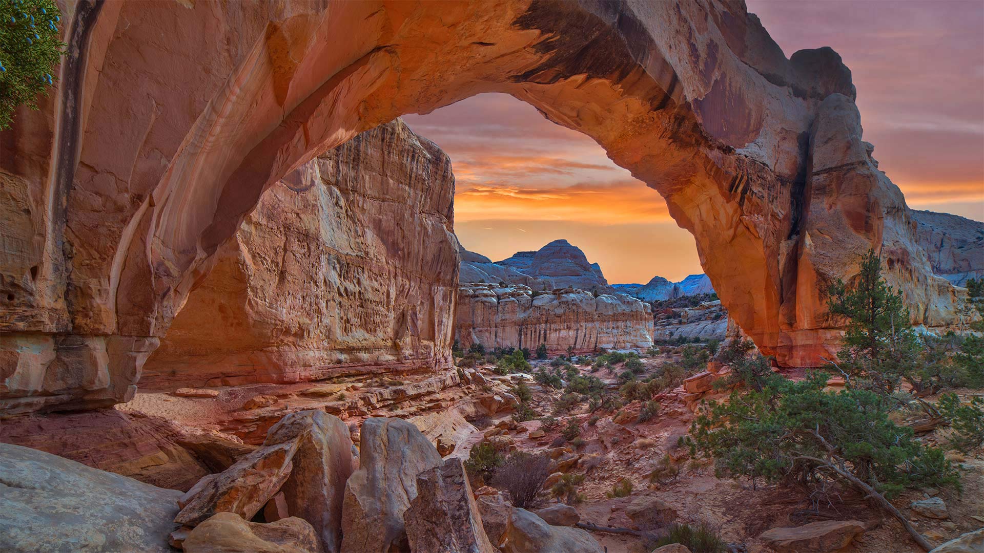
圆顶礁国家公园里的希克曼桥,美国犹他州 The Hickman Bridge at Capitol Reef National Park, Utah (© Tim Fitzharris/Minden Pictures)
走上这条人迹常见的小径 Take the trail more traveled by
Happy Birthday Capitol Reef National Park
You won't find a lot of solitude on the Hickman Bridge Trail, a 1.7-mile route in Capitol Reef National Park that leads to this magnificent natural arch. The trail is used by hikers, runners, and nature lovers drawn by incredible rock formations, gullies, and remnants from the Fremont Culture Native American civilization from the early part of the 20th century. Hickman Bridge itself is one of the best-known geologic features of the park.
Capitol Reef National Park was first established as a national monument on this day in 1937, then became a national park in 1971. Capitol Reef is named for its massive rock domes that reminded nearby residents of that famous rotunda of the US Capitol Building back in Washington, DC. Why Capitol 'Reef,' though? Because the imposing formations were major obstacles to travelers through the region, the same way a coral reef is an obstacle to sailors.
The geology of the park is defined by the nearly 100-mile Waterpocket Fold, a wrinkle in the Earth's crust that formed around the end of the dinosaur era. Wind, rain, and time have eroded the Navajo Sandstone into colorful canyons, buttes, and natural arches like Hickman Bridge. The dramatic rock formations make Capitol Reef a favorite destination in the American West.
生日快乐国会山珊瑚礁国家公园
在希克曼大桥小径上你不会发现太多的孤独,这条小径位于国会山礁国家公园,全长1.7英里,通往这座宏伟的天然拱门。这条小径供远足者、跑步者和自然爱好者使用,它们由难以置信的岩层、沟壑和20世纪早期弗里蒙特文化-美洲原住民文明的遗迹绘制而成。希克曼大桥本身就是公园最著名的地质特征之一。
国会山礁国家公园于1937年的今天首次作为国家纪念碑建立,然后在1971年成为国家公园。国会山礁以其巨大的岩石圆顶而命名,这让附近的居民想起了位于华盛顿特区的美国国会大厦的著名圆形大厅。然而,为什么国会大厦是“暗礁”?因为壮观的地形是该地区旅行者的主要障碍,就像珊瑚礁是水手的障碍一样。
公园的地质特征是近100英里的水袋褶皱,这是在恐龙时代末期形成的地壳褶皱。风、雨和时间把纳瓦霍砂岩侵蚀成了五颜六色的峡谷、山丘和希克曼大桥那样的天然拱门。引人注目的岩层使国会山礁成为美国西部最受欢迎的目的地。
北狼丘里的"波浪谷",美国亚利桑那州 'The Wave' sandstone formation in Coyote Buttes North, Paria Canyon-Vermilion Cliffs National Monument, Arizona (© Dennis Frates/Alamy)
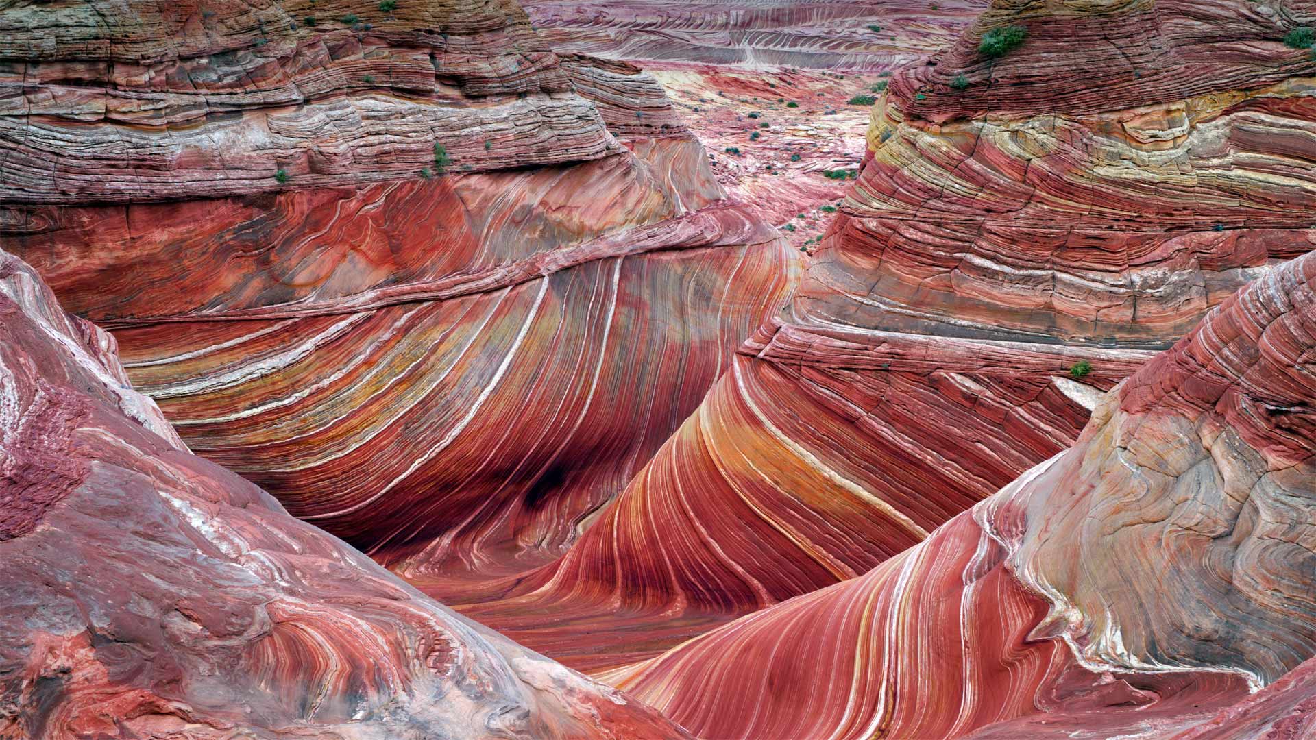
北狼丘里的"波浪谷",美国亚利桑那州 'The Wave' sandstone formation in Coyote Buttes North, Paria Canyon-Vermilion Cliffs National Monument, Arizona (© Dennis Frates/Alamy)
乘风破浪 Ride the wave
The Wave at Coyote Buttes
By showing you this coveted sight, we're saving you a bit of an ordeal. For a close-up view like this of 'The Wave,' a whorled sandstone formation in the northern Arizona wilderness, you'd have to navigate a rugged and mostly trail-free hiking route in typically scorching temperatures. You'd also need to have a permit in your pocket. To protect the landscape, only a small number are available, offered through a daily lottery. But maybe for you the journey is at least as important as the destination? If so, this is just one hike of many in the expansive Paria Canyon-Vermilion Cliffs National Monument, which protects more than 100,000 acres of Arizona and Utah canyonland.
郊狼丘上的波浪
通过向你们展示这一令人垂涎的景象,我们为你们省去了一点磨难。要想近距离拍摄“The Wave”,这是亚利桑那州北部荒野中的一个螺纹砂岩地层,你必须在典型的酷热天气下,沿着崎岖不平、几乎没有足迹的徒步路线行走。你还需要口袋里有许可证。为了保护景观,只有少数人可以通过每日彩票获得。但也许对你来说,旅程至少和目的地一样重要?如果是这样的话,这只是帕里亚峡谷朱红色悬崖国家纪念碑中众多徒步旅行中的一次,该纪念碑保护着亚利桑那州和犹他州超过10万英亩的峡谷地。
山下盛开的箭叶脂根菊,美国大提顿国家公园 Balsamroot wildflowers bloom below the Teton Mountains in Grand Teton National Park, Wyoming (© Mike Cavaroc/Tandem Stills + Motion)
山下盛开的箭叶脂根菊,美国大提顿国家公园 Balsamroot wildflowers bloom below the Teton Mountains in Grand Teton National Park, Wyoming (© Mike Cavaroc/Tandem Stills + Motion)
壮丽的景色 A grand view
Grand Teton National Park
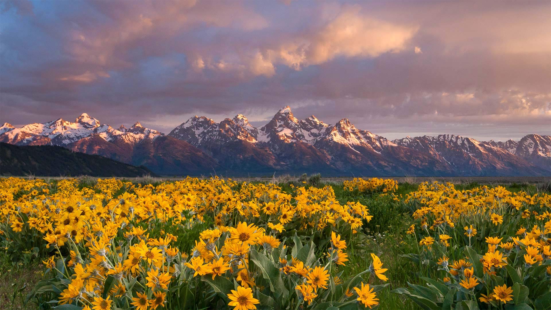
These arrowleaf balsamroot wildflowers, commonly known as Oregon sunflowers, have a grand view of the Grand Tetons from the valley below the towering range. The region's harsh weather means that only the hardiest of wildflowers can survive, and the bright yellow arrowheads fit the bill. The plants are drought tolerant, winter hardy, tenacious against trampling, and even fire resistant, with a taproot which regenerates leaves and flowers after the top has burned.
Located just 10 miles from Yellowstone National Park, Grand Teton National Park and the surrounding national forests constitute the almost 18-million-acre (28,000-square-mile) Greater Yellowstone Ecosystem, one of the world's largest intact mid-latitude temperate ecosystems. There's something for every lover of the outdoors here, and the park is a popular destination for mountaineering, hiking, fishing, and other forms of recreation, with more than 1,000 drive-in campsites and over 200 miles of hiking trails that provide access to backcountry camping areas. Grand Teton National Park is one of the 10 most popular parks in the United States.
大提顿国家公园
这些箭叶香根野花,俗称俄勒冈州向日葵,从高耸山脉下方的山谷中可以俯瞰大提顿。该地区恶劣的天气意味着只有最顽强的野花才能生存,而明亮的黄色箭头正好符合这一要求。这些植物耐旱、耐寒、抗践踏、甚至耐火,主根在顶部燃烧后再生叶子和花朵。
大提顿国家公园距离黄石国家公园仅10英里,它和周围的国家森林构成了近1800万英亩(28000平方英里)的大黄石生态系统,是世界上最大的完整中纬度温带生态系统之一。这里有适合每一位户外爱好者的东西,公园是登山、徒步旅行、垂钓和其他娱乐形式的热门目的地,有1000多个免下车露营地和200多英里的徒步小道,可以进入偏远的露营区。大提顿国家公园是美国十大最受欢迎的公园之一。
大弯曲国家公园的塞拉庞塞和格兰德河边的悬崖,美国得克萨斯州 Cliffs of the Sierra Ponce and Rio Grande River, Big Bend National Park, Texas (© Tim Fitzharris/Minden Pictures)
大弯曲国家公园的塞拉庞塞和格兰德河边的悬崖,美国得克萨斯州 Cliffs of the Sierra Ponce and Rio Grande River, Big Bend National Park, Texas (© Tim Fitzharris/Minden Pictures)
奇瓦瓦沙漠中的一处偏远绿洲 A remote oasis in the Chihuahuan Desert
Big Bend National Park turns 78
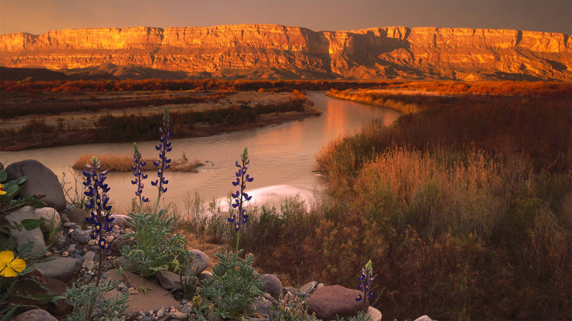
Join us for a hike at one of America's least-visited national parks. Big Bend National Park may be among the country's largest national parks with an area of over 800,000 acres (about the area of Rhode Island), but it's also one of the most remote. Found in West Texas along the Rio Grande at the Mexico border, the park entrance is roughly a two-hour drive from the nearest interstate. The good thing is, even in a 'busy' year when half a million people visit, there's plenty of space to enjoy the great outdoors unhindered by crowds.
Added to the national park system on this day in 1944, Big Bend contains the largest protected area of the Chihuahuan Desert in the United States. It's also known for having the darkest night skies among the contiguous states. This makes it a 'must visit' for stargazing; thousands of stars are visible when the skies are clear, along with the Milky Way. If you head out for a hike, keep your eyes peeled for the 1,200 plant species in the park. There are also plenty of animals, though most of them tend to come out only at night. Except birds, that is. Birdwatching is incredibly popular at Big Bend–it's on the paths of annual migrations, so more than 450 different bird species have been cataloged here.
大弯国家公园78岁
加入我们,在美国游客最少的国家公园之一徒步旅行。大弯国家公园可能是美国最大的国家公园之一,面积超过800000英亩(大约相当于罗德岛的面积),但它也是最偏远的国家公园之一。公园入口位于得克萨斯州西部,沿墨西哥边境的格兰德河,距离最近的州际公路大约两小时车程。好消息是,即使是在50万人来访的“繁忙”年份,也有足够的空间来享受美妙的户外活动,不受人群的阻碍。
1944年的今天,大本德被纳入国家公园系统,是美国最大的奇瓦瓦沙漠保护区。它还因拥有邻近各州中最黑暗的夜空而闻名。这使得它成为观星的“必到之地”;当天空晴朗时,数千颗恒星与银河系一起可见。如果你要去远足,一定要留意公园里的1200种植物。这里也有很多动物,尽管它们大多只在晚上出来。就是说,除了鸟。大本德的观鸟活动非常受欢迎,因为每年都有鸟类迁徙,所以这里有450多种不同的鸟类。
加勒廷国家森林里的小溪,美国蒙大拿州 Hyalite Creek in the Custer Gallatin National Forest, Montana (© Jared Lloyd/Getty Images)
加勒廷国家森林里的小溪,美国蒙大拿州 Hyalite Creek in the Custer Gallatin National Forest, Montana (© Jared Lloyd/Getty Images)
垂钓者的天堂 An angler's paradise
Hyalite Creek at Custer-Gallatin National Forest, Montana
Today we're taking a little fishing trip just south of Bozeman, Montana, to Hyalite Creek, which runs through Custer Gallatin National Forest. This is one of the most heavily visited recreation areas in Montana, especially for those who like to fish. Late 1800s logging operations in the surrounding forest damaged the habitat for trout in Hyalite Creek, but stream restoration projects have increased trout populations to such an extent that this is now considered a world-class destination for fly fishing.
Even if you're not the fishing type, the ecologically diverse landscapes of Custer Gallatin National Forest will delight most any visitor. Stretching across more than 3 million acres, there's plenty of hiking, camping, and mountain climbing to be had. If you're up for something a little different, hop over to Grasshopper Glacier in the Beartooth Mountains. Entombed inside the ice are millions of the now extinct Rocky Mountain locusts that were trapped long ago while swarming during severe storms.
蒙大拿州卡斯特加拉廷国家森林的Hyalite溪
今天,我们将在蒙大拿州博兹曼南部进行一次小钓鱼之旅,前往穿过卡斯特加拉廷国家森林的Hyalite Creek。这是蒙大拿州游客最多的休闲区之一,尤其是对于那些喜欢钓鱼的人来说。19世纪后期,在周围森林进行的伐木作业破坏了Hyalite Creek鳟鱼的栖息地,但河流恢复项目增加了鳟鱼的数量,以至于现在这里被认为是世界级的飞钓目的地。
即使你不是钓鱼爱好者,卡斯特·加拉廷国家森林的生态多样性景观也会让所有游客感到愉悦。绵延300多万英亩,有大量的徒步旅行、露营和登山活动。如果你想做一些不同的事情,那就跳到Beartooth山脉的Grasshopper Glacier。数百万现已灭绝的落基山脉蝗虫被埋在冰中,这些蝗虫很久以前就被困在暴风雨中成群结队。
金门大桥和马林岬角,美国加利福尼亚州 Golden Gate Bridge and Marin Headlands photographed from Golden Gate Overlook in San Francisco, California (© Jeff Lewis/Tandem Stills + Motion)
金门大桥和马林岬角,美国加利福尼亚州 Golden Gate Bridge and Marin Headlands photographed from Golden Gate Overlook in San Francisco, California (© Jeff Lewis/Tandem Stills + Motion)
没有哪儿比这里更能代表旧金山… Nothing says 'San Francisco' quite like...
Golden Gate Bridge, San Francisco
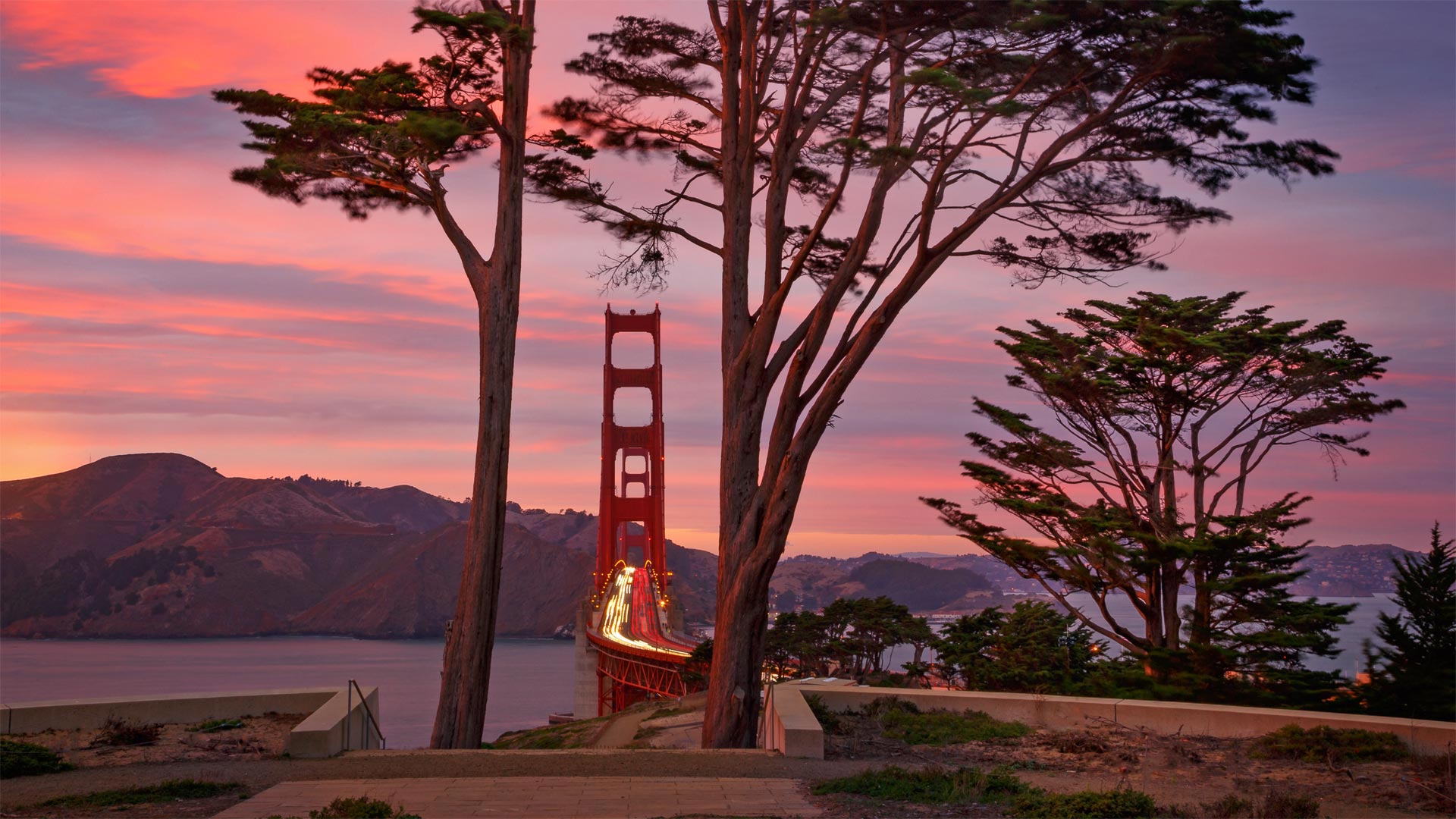
Few structures achieve the status of the Golden Gate Bridge—so recognizable that it needs no introduction. Opened on this day in 1937, the bridge was a marvel of engineering, built to withstand ferocious winds above and swirling currents below. Its construction was embraced by the local population because it would finally connect the rising metropolis of San Francisco to communities in Marin County and all that lay north. Before the bridge was completed, a ferry was the only way across the Golden Gate, the mile-wide strait that connects the Pacific Ocean to San Francisco Bay. Building a bridge to cross the span would be no small feat, and many thought it impossible.
Financing for the construction was another hurtle and was put further at risk with the Great Crash of 1929. But eventually voters in the Bay Area supported a bond measure worth $35 million ($473 million today), using their homes, farms, and business properties as collateral—the infusion of cash allowed construction to begin in 1933. In the midst of the Great Depression, the bridge became a jobs generator, putting 2,000 men to work. In four years they completed the engineering triumph ahead of schedule and under budget.
Its two towers rise to 755 feet above the water, and the span suspended between them is 4,200 feet long, which made it the longest suspension bridge in the world upon its completion. Seventeen longer suspension bridges have since been built (most of them in China), but the Golden Gate remains the star among them, considered the most beautiful, most photographed, a symbol of American style and ingenuity, and a calling card for a city. There are few better reasons to leave your heart in San Francisco.
旧金山金门大桥
很少有建筑能达到金门大桥的地位,因此不需要引入。这座桥于1937年的今天开通,是一座工程奇迹,它的建造可以抵御上方的狂风和下方的涡流。它的建设受到了当地居民的欢迎,因为它最终将连接旧金山这座正在崛起的大都市与马林县以及所有北部地区的社区。在大桥建成之前,渡船是穿越金门的唯一途径,金门是连接太平洋和旧金山湾的一英里宽的海峡。建造一座横跨这座桥将是一项不小的壮举,许多人认为这是不可能的。
建筑融资是另一个突如其来的问题,1929年的大崩盘使其面临更大的风险。但最终,海湾地区的选民支持一项价值3500万美元(今天为4.73亿美元)的债券措施,将他们的房屋、农场和商业地产作为抵押品。1933年,注入的现金使建设得以开始。在大萧条期间,这座桥创造了就业机会,使2000人就业。在四年内,他们在预算内提前完成了工程胜利。
它的两座塔楼高出水面755英尺,两座塔楼之间的跨度为4200英尺,建成后成为世界上最长的悬索桥。自那以后,已经建造了17座更长的吊桥(大部分在中国),但金门仍然是其中的明星,被认为是最美丽、拍照最多的吊桥,是美国风格和创造力的象征,也是城市的名片。没有什么更好的理由可以把你的心留在旧金山。
春天的豹溪瀑布,吉福德·平肖国家森林,美国华盛顿州 Panther Creek Falls in spring, Gifford Pinchot National Forest, Washington (© Stephen Matera/Tandem Stills + Motion)
春天的豹溪瀑布,吉福德·平肖国家森林,美国华盛顿州 Panther Creek Falls in spring, Gifford Pinchot National Forest, Washington (© Stephen Matera/Tandem Stills + Motion)
拥有6000年历史的大森林 A large forest with 6,000 of years of history
Gifford Pinchot National Forest
Today we're paying a visit to an 'elder statesman' of the United States' national forests. Seen in today's photo is Panther Creek Falls at Gifford Pinchot National Forest in Washington state. Officially, the forest was named in 1949 in honor of Pinchot, the first head of the US Forest Service. Located between Mount St. Helens to the west and Mount Adams to the east, the land was set aside as a place worth preserving as far back as 1897. But people had been living in the forest for more than 6,000 years. Archaeologists continue to make discoveries within the dense forest that teach us about the past lives of Native Americans.
Spanning 1.3 million acres, GPNF exhibits an array of natural wonders: forests, wildlife, mountains, and numerous rivers and lakes that offer excellent fishing. Goose Lake is said to be the best fishing hole in the state. The forest is known as a native habitat for several threatened species, like the spotted owl, bull trout, and chinook salmon. One of the largest known Ponderosa pines in the world rose 202 feet at the base of Mount Adams before its death in 2015. The grounds also include the 110,000-acre Mount St. Helens National Volcanic Monument, established in 1982.
吉福德平肖国家森林
今天我们要拜访美国国家森林的一位“资深政治家”。在今天的照片中可以看到华盛顿州吉福德平肖国家森林的豹溪瀑布。该森林于1949年正式命名,以纪念美国林业局第一任局长平肖。这片土地位于西面的圣海伦斯山和东面的亚当斯山之间,早在1897年就被作为一个值得保护的地方保留下来。但是人们已经在森林里生活了6000多年。考古学家继续在茂密的森林中进行发现,让我们了解美洲原住民的过去生活。
GPNF占地130万英亩,展示了一系列自然奇观:森林、野生动物、山脉,以及无数河流和湖泊,这些河流和湖泊提供了极好的渔业。鹅湖据说是该州最好的渔场。这片森林被称为几种濒危物种的原生栖息地,如斑点猫头鹰、牛鳟鱼和奇努克鲑鱼。2015年亚当斯山死亡前,世界上已知最大的黄松之一在亚当斯山的底部上升了202英尺。场地还包括建于1982年的占地11万英亩的圣海伦斯山国家火山纪念碑。
梅萨维德国家公园的方形塔楼,美国科罗拉多州 Square Tower House in Mesa Verde National Park, Colorado (© lightphoto/Getty Images)
梅萨维德国家公园的方形塔楼,美国科罗拉多州 Square Tower House in Mesa Verde National Park, Colorado (© lightphoto/Getty Images)
普韦布洛城堡 Castle of the Ancestral Puebloans
Square Tower House in Mesa Verde National Park
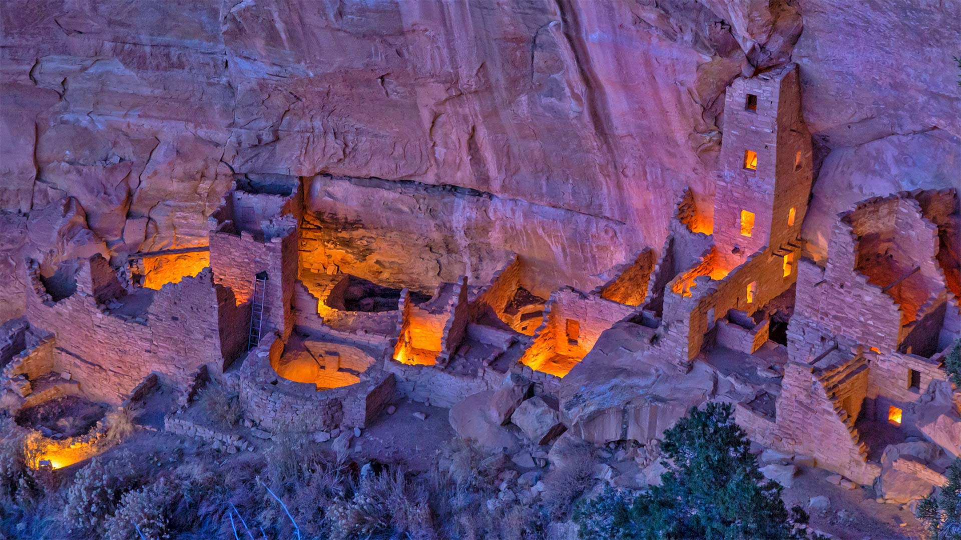
We continue our celebration of National Park Week (through April 24)–and the UNESCO International Day for Monuments and Sites–with a visit to the impressive Square Tower House in Mesa Verde National Park. Square Tower House is one of many cliff dwellings constructed by the Ancestral Puebloans in what is now the American Southwest. At 27 feet, it's the tallest structure in the park. Square Tower House is also notable for its kiva, a round, sunken room used for ceremonies. Unlike most of the ancient kivas found in the region, the kiva at Square Tower House has an intact original clay roof supported by wooden beams.
Ancestral Puebloans lived in today's Four Corners region, where the borders of Colorado, Utah, Arizona, and New Mexico meet at a single point. It's unclear when exactly this culture emerged, but the current consensus is that the Ancestral Puebloans appeared in this area a little more than 3,000 years ago. They're believed to have built the series of cliff dwellings for defensive reasons as various factions competed for scarce resources when the region suffered from a prolonged drought. It's thought that the changing climate eventually became so severe that it likely drove them from the cliff dwellings sometime around 1300 CE, just a century or so after construction began. Today, many of the cliff dwellings have been restored and visitors can view the homes and kivas of the builders.
梅萨维德国家公园的方形塔楼
我们继续庆祝国家公园周(至4月24日)——以及联合国教科文组织纪念物和遗址国际日——参观梅萨维德国家公园令人印象深刻的方形塔楼。方塔住宅是普埃布劳恩斯家族在现在的美国西南部建造的众多悬崖住宅之一。它高27英尺,是公园里最高的建筑。方形塔楼房屋也因其kiva而著名,kiva是一个圆形的下沉式房间,用于举行仪式。与该地区发现的大多数古代基瓦不同,广场塔楼的基瓦房屋有一个完整的原始粘土屋顶,由木梁支撑。
普韦布劳恩斯的祖先生活在今天的四角地区,科罗拉多州、犹他州、亚利桑那州和新墨西哥州的边界在这里交汇。目前尚不清楚这种文化是什么时候出现的,但目前的共识是,祖先普韦布洛人在3000多年前就出现在这个地区。据信,当该地区遭受长期干旱时,各派系为了争夺稀缺资源,出于防御原因,他们修建了一系列悬崖住宅。据认为,气候变化最终变得如此严重,可能在公元1300年左右的某个时候,也就是建筑开始后的一个世纪左右,将他们赶出悬崖住宅。如今,许多悬崖上的住宅已经修复,游客可以看到建筑商的房屋和地窖。