标签 美国 下的文章
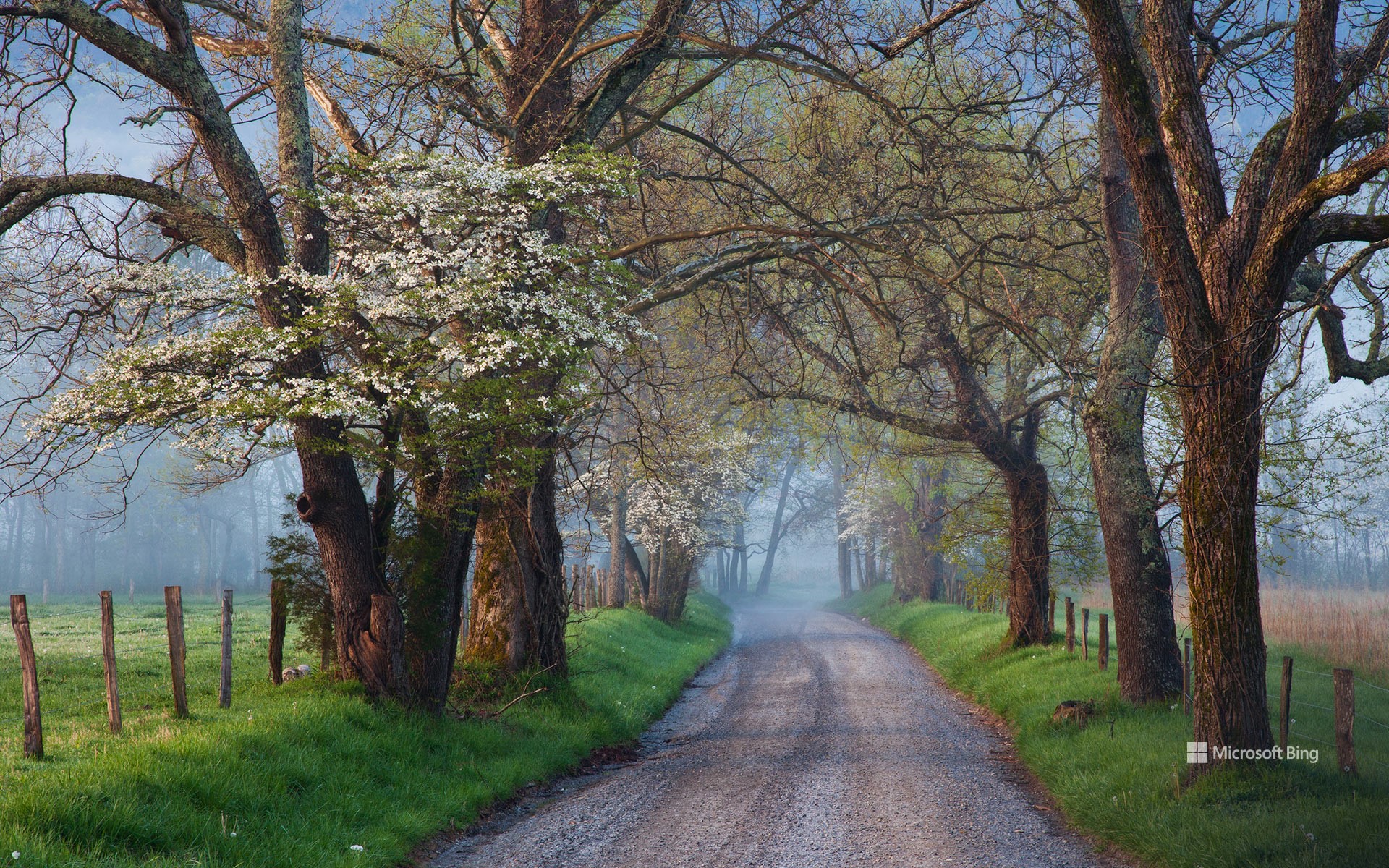
Cades Cove ,大雾山国家公园,田纳西州,美国 Sparks Lane in Cades Cove, Great Smoky Mountains National Park, Tennessee (© Richard Bernabe/Shutterstock)
Cades Cove ,大雾山国家公园,田纳西州,美国 Sparks Lane in Cades Cove, Great Smoky Mountains National Park, Tennessee (© Richard Bernabe/Shutterstock)
未选择的路 The road not taken
国家公园周活动继续开展
随着美国国家公园周活动的开展,让我们一起去田纳西州的大雾山国家公园走走吧!该公园成立于1934年,占地面积超过522,419英亩。这座公园的大部分地区都被森林覆盖着,是1500种开花植物、952种藻类、65种哺乳动物和240多种鸟类的家园,大雾山国家公也因此成为了国际生物圈保护区。
在今天的照片中看到的开字山凹是大雾山国家公园内的一个山谷,以其迷人的风景和历史建筑(包括小木屋、谷仓和教堂)而闻名。在探索公园的同时,你还可以参观咆哮叉机动车自然小径、卡特罗基山和埃尔克蒙特等历史名胜。如果你想看萤火虫,埃尔克蒙特就是你的不二之选。如果你是一名地质学家,这里也有适合你的东西:这个公园是前寒武纪晚期岩石的家园。所以,释放你的冒险精神,与其他人一起去探索国家公园吧!
National Park Week continues
As National Park Week unfurls its green banners, let's take a stroll down Sparks Lane, in Great Smoky Mountains National Park, Tennessee. Established in 1934, the park encompasses over 522,419 acres of wilderness, mostly covered with forests. It is home to 1,500 species of flowering plants, 952 algae, 65 species of mammals, and over 240 species of birds, making it an International Biosphere Reserve.
Cades Cove—seen in today's photo—is a valley renowned for its scenery and historic structures, including log cabins, barns, and churches. While exploring the park, you can also visit historical areas like Roaring Fork, Cataloochee, and Elkmont. If you wish to watch fireflies, then Elkmont is the place for you, and if you are a geologist, there's something for you too: This park is home to late Precambrian rocks. So, set your spirit of adventure free and join others to celebrate the timeless American treasure: national parks!
日出时分的大棱镜泉,美国怀俄明州黄石国家公园 Grand Prismatic Spring at sunrise, Yellowstone National Park, Wyoming (© XIN WANG/Getty Images)
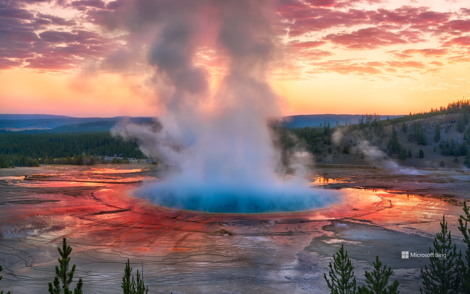
日出时分的大棱镜泉,美国怀俄明州黄石国家公园 Grand Prismatic Spring at sunrise, Yellowstone National Park, Wyoming (© XIN WANG/Getty Images)
保存,保护,享受! Preserve, protect, enjoy!
国家公园周开幕
准备好你的登山靴吧,因为美国国家公园周到了!美国各地最迷人的风景区已敞开大门,邀请大家免费拥抱大自然。在整个庆祝活动期间,美国国家公园管理局将组织各种活动,包括由护林员带领的参观活动、志愿者活动和教育研讨会。
如果你在怀俄明州,您可能想去黄石国家公园看看。作为世界上第一个国家公园,该公园以其植物群、动物群(包括落基山狼、灰熊和黑熊)、超级火山和许多地热景观而闻名,而今天的图片上的大棱镜泉正是其中之一。位于中间歇泉盆地的大棱镜泉从里向外呈现出蓝、绿、黄、橙、红等不同颜色,这种现象是由水体中生活的藻类和含色素的细菌等微生物造成的。外面有太多的东西等着你去探索,所以快召集你的朋友,到野外去吧。
National Park Week begins
Get ready to lace up your hiking boots, because National Park Week is upon us! Across the country, America's most stunning landscapes throw their gates wide open, inviting everyone to embrace the great outdoors for free. Throughout the celebration, various programs will be organized by the National Park Service, including ranger-led tours, volunteer opportunities, and educational workshops.
If you are in Wyoming, you might want to visit Yellowstone, the world's first national park. Established in 1872 by President Ulysses S. Grant, the park is known for its flora, fauna—including Rocky Mountain wolves, and grizzly and black bears—supervolcano, and many geothermal features, including the one we see in today's image. The Grand Prismatic Spring is in the Midway Geyser Basin. Its display of colors is caused by multi-layered sheets of microorganisms, ranging from deep blues and greens to fiery oranges and reds. There is so much waiting to be explored out there, so gather your friends and get out into the wild.
暮色中的曼哈顿下城联合广场,纽约,美国 Union Square in lower Manhattan at twilight, New York (© Sean Pavone/Getty Images)
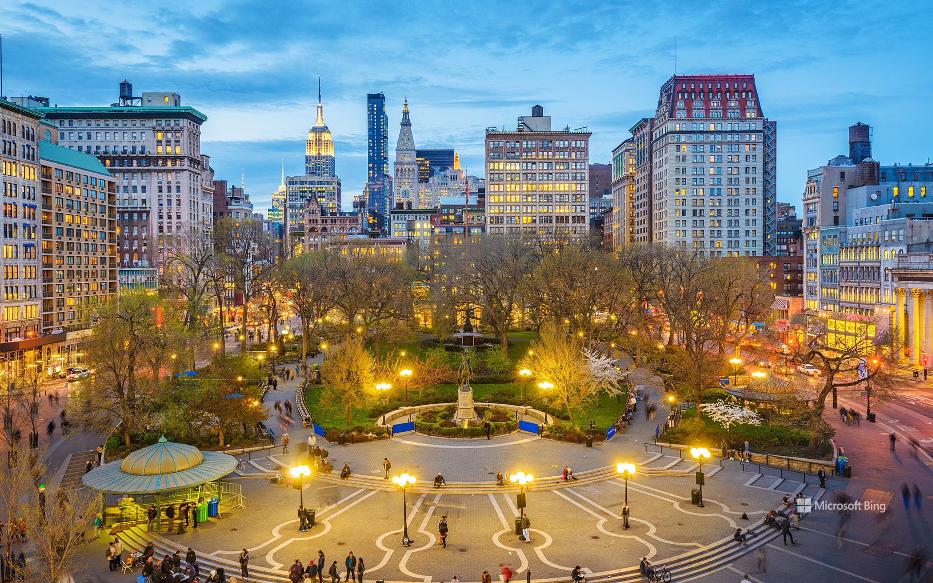
暮色中的曼哈顿下城联合广场,纽约,美国 Union Square in lower Manhattan at twilight, New York (© Sean Pavone/Getty Images)
灯光,相机,纽约! Lights, camera, New York!
联合广场,曼哈顿,纽约
“纵横交错的街道令人焕然一新,璀璨的霓虹灯让人热血沸腾。” 流行歌手艾丽西亚·凯斯在歌曲《帝国之心》中这样描述大苹果市(纽约的别称)的繁华与活力。今天,主页的图片将我们带到 “不夜城 ”的其中一个景点:曼哈顿下城的联合广场。在这个历史悠久的十字路口,您可以看到乔治·华盛顿的雕像,它是纽约市所有公园中最古老的雕像,以及雕塑家亨利·柯克·布朗创作的亚伯拉罕·林肯的雕像。1882年,工人们行使他们言论自由和集会自由的权利,在联合广场组织了第一次劳动节游行。正因如此,联合广场在美国劳工史上具有特殊的意义,1997年美国内政部将其认定为国家历史地标。时光飞逝,如今的曼哈顿更加繁华,当你漫步在街头,或许会在广场上看到街头棋手、音乐家、滑板爱好者、舞蹈团体和各类小贩。
Union Square, Manhattan
'These streets will make you feel brand new, big lights will inspire you.' Alicia Keys sure knows how to serenade the vibrant, bustling life of the Big Apple. Today's homepage image takes us to Union Square in lower Manhattan. At this historic intersection, you can find statues of George Washington—the oldest statue in any park in NYC—and Abraham Lincoln, crafted by the sculptor Henry Kirke Brown. In 1882, workers exercised their rights to free speech and assembly, organizing the first Labor Day parade here. In 1997, Union Square was recognized as a National Historic Landmark due to its importance in US labor history. These days, you're more likely to see street chess players, musicians, skateboarders, dance crews, and vendors of all types in the square.
保龄球海滩的日落,门多西诺县,加利福尼亚,美国 Sunset on Bowling Ball Beach, Mendocino County, California (© Melo Qiao/Getty Images)
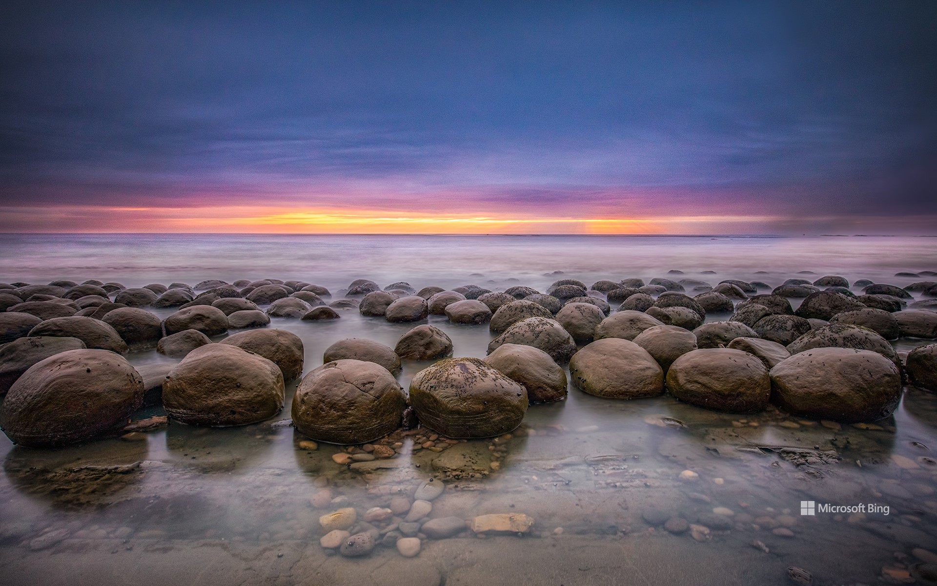
保龄球海滩的日落,门多西诺县,加利福尼亚,美国 Sunset on Bowling Ball Beach, Mendocino County, California (© Melo Qiao/Getty Images)
岩石保龄球 Rock 'n' bowl
保龄球海滩,加利福尼亚州
欢迎来到大自然的保龄球馆!位于加州门多西诺海岸的保龄球海滩以散布在海岸上的那些引人注目的岩石而命名。这些砂岩球(一种被称为结核的现象)是在数百万年的沉积过程中形成的,沉积层围绕着由矿物胶结物固定在一起的砂石核心堆积而成。侵蚀作用逐渐磨损了外层,露出我们今天看到的球形。这创造了一个只有在退潮时才会出现的迷人景象。这种砂岩球很罕见,人们对它们的来源有很多疯狂的猜测,有人认为它们是外星碎片,也有人怀疑它们是恐龙化石。然而,答案非常简单:这是大自然的力量在起作用。
Bowling Ball Beach in Mendocino County, California
Welcome to nature's bowling alley. Bowling Ball Beach on the Mendocino Coast in California is named after the striking rock formations strewn across the shore. These sandstone balls—a phenomenon known as concretions—formed over millions of years as sedimentary layers built up around a central core of sand and stone held together by mineral cements. Erosion gradually wore away the outer layers to expose the spherical shapes we see today. This created a fascinating spectacle that only appears at low tide. Concretions are rare, and there has been plenty of wild speculation about where they come from, with some believing them to be extraterrestrial debris while others wonder if they are dinosaur fossils. The answer, however, is quite simple: It is the forces of nature at play.
拱门国家公园,犹他州,美国 Evening light over North Window with Turret Arch in the distance, Arches National Park, Utah (© Anthony Heflin/Shutterstock)
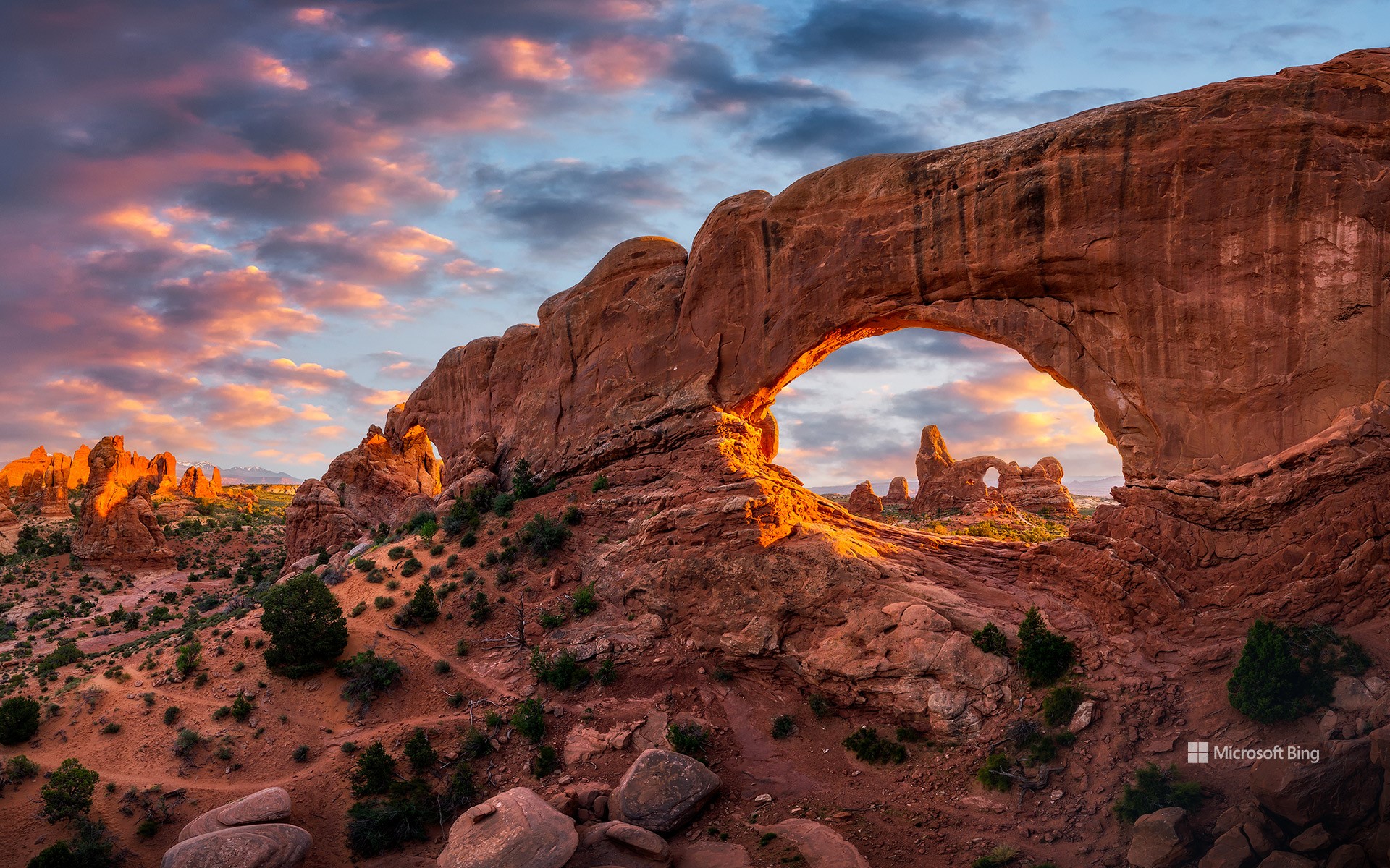
拱门国家公园,犹他州,美国 Evening light over North Window with Turret Arch in the distance, Arches National Park, Utah (© Anthony Heflin/Shutterstock)
一座天然拱门 A work of arch
犹他州拱门国家公园
如果你想沉浸式感受在时光中漫步的滋味,拱门国家公园是一个绝佳的选择!该公园拥有2000多座天然石拱,数百座高大的尖塔、大型石鳍和巨大的平衡石,是世界上风景最优美的旅游胜地之一。在两平方英里左右的空间内囊括了不少壮丽景观,包括北窗拱门(最具人气的巨环之一),炮塔拱门和双拱门。而以伊甸园、大象丘(5653英尺高)和大象巡游等名字命名的景点对游客而言,则意味着这里永远不缺壮观的景色。
这个地区曾经是隐藏在数千英尺地下的广阔且干涸的海床。然而,随着时间的流逝,地质力量逐渐改变了这里的地貌,形成了我们今天看到的壮观景象。人类在这里探索和生活了数千年,大约2000年前,这个地区的游牧民族开始种植农作物。然而,因气候变化而加剧的环境问题最终导致了农耕活动的减少。
Arches National Park, Utah
If you fancy a stroll through time, Arches National Park is the perfect gateway! With over 2,000 natural stone arches, hundreds of tall pinnacles, large rock fins, and giant balanced rocks, this park is among the world's most scenic destinations. In the popular Windows Section, covering just over 2 square miles, there are spectacular rock formations including North Window, Turret Arch, and Double Arch. Others include Garden of Eden, Elephant Butte, a 5,653-foot summit, and Parade of Elephants, so visitors are never short of awesome sights to enjoy.
The region was once a vast dry seabed hidden beneath thousands of feet of earth but was gradually transformed by geological forces to become the spectacular space we see today. Humans have explored and lived in this area for millennia. Around 2,000 years ago, its nomadic inhabitants began to cultivate crops. However, environmental challenges, possibly aggravated by climate shifts, eventually led to a decline in farming activities.
郁金香田,斯卡吉特山谷,华盛顿州,美国 Tulip fields in spring, Skagit Valley, Washington (© Claudia Cooper/Getty Images)
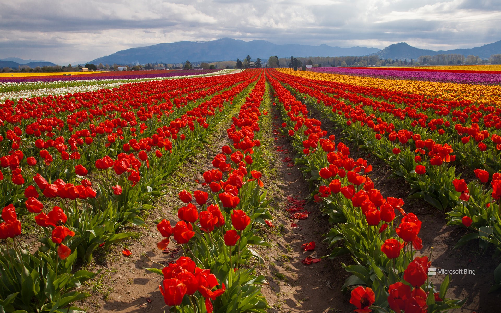
郁金香田,斯卡吉特山谷,华盛顿州,美国 Tulip fields in spring, Skagit Valley, Washington (© Claudia Cooper/Getty Images)
踮起脚尖,穿过郁金香 Tiptoe through the tulips
斯卡吉特山谷郁金香节
在弗农山的阴影下,鲜艳的花朵为大地涂上一层色彩,造就了一幅真实的画卷,华盛顿斯卡吉特山谷的郁金香节正在等你。郁金香节于1984年由弗农山商会创办,最初的活动为期三天,后来发展成为为期一个月的盛会。节日从四月持续到五月,吸引了来自世界各地的游客。花展横跨山谷中的多个花园,千万不要错过郁金香镇、郁金香谷农场、罗莎琳花园以及鲁森加德占地50英亩的花展,你可以骑自行车游览郁金香花园,还可以探索当地的酒庄、酿酒厂和餐馆。漫步花间,生活放慢了脚步,让我们记住简单的快乐:深呼吸,绽放笑容,沉醉在斯卡吉特山谷郁金香节的美景中。
Skagit Valley Tulip Festival in Washington
Walk through a real-life canvas in a farming valley in Washington, where vibrant blossoms paint the Earth. That's exactly what awaits you at the Skagit Valley Tulip Festival, held in the city of Mount Vernon and surrounding towns. Founded in 1984 as a three-day event, it has grown into a month-long fiesta which runs from April to May and draws visitors from all over the world. The floral show spans multiple gardens in the valley, so make sure you explore Tulip Town, Tulip Valley Farms, Garden Rosalyn, and the 50-acre display at RoozenGaarde. You can tour the tulip gardens by bicycle and explore the local wineries, breweries, and restaurants. Among the petals, life slows down just enough for us to remember the simple joys—breathe deeply, smile widely, and revel in nature's spectacle.
盛开的扁桃树, 加利福尼亚州,美国 Almond trees in full bloom, California (© Jeffrey Lewis/Tandem Stills + Motion)
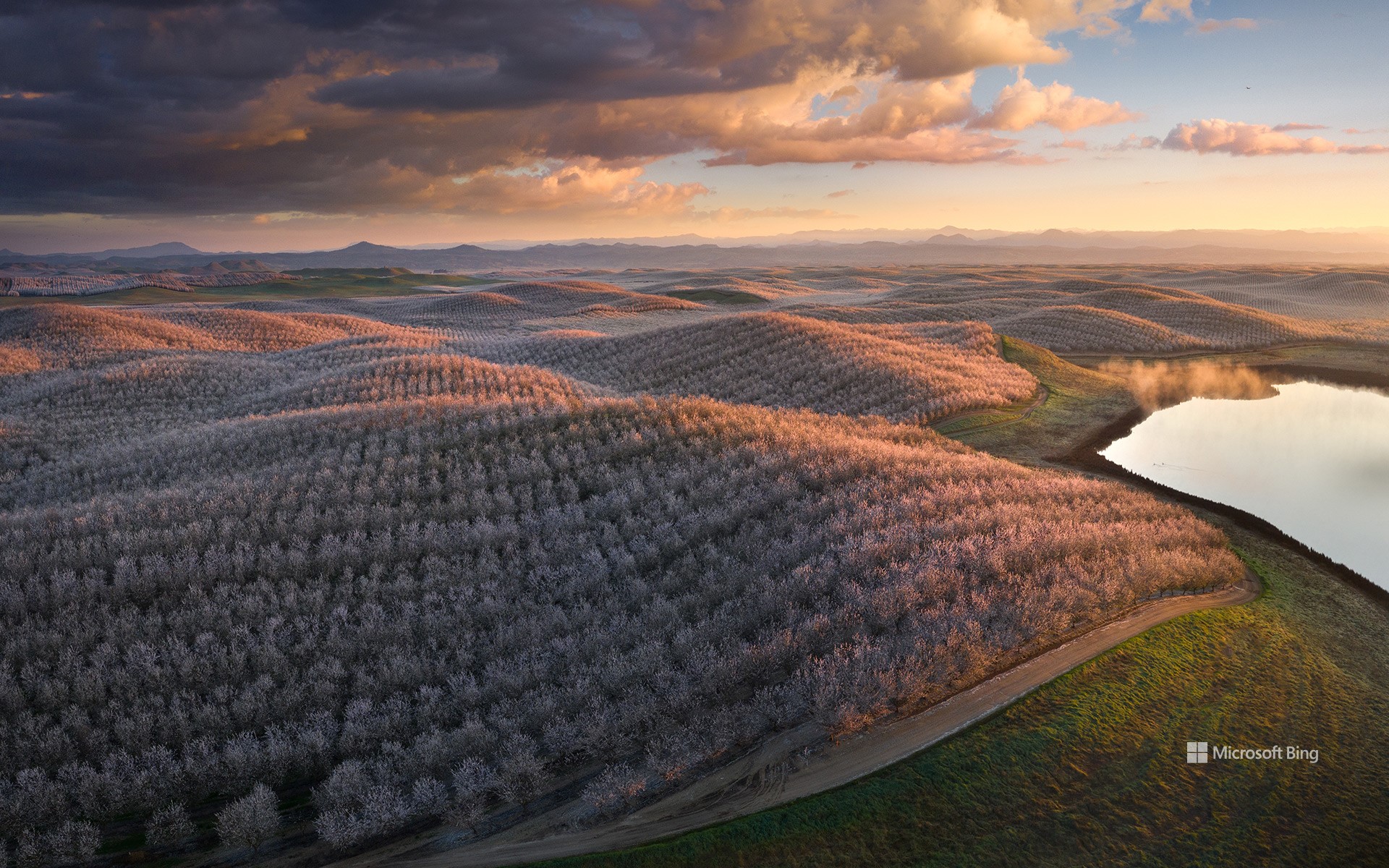
盛开的扁桃树, 加利福尼亚州,美国 Almond trees in full bloom, California (© Jeffrey Lewis/Tandem Stills + Motion)
春日私语 Whispers of spring
盛开的扁桃树, 加利福尼亚州
在阳光普照的金州(加利福尼亚州的别称)果园中,扁桃仁享有崇高的地位,它以美味的果实诱惑着人们的味蕾,用漂亮的花朵装点着自然环境。而加利福尼亚州种植的扁桃仁占世界市场供应量的80%,占美国市场供应量的100%。据悉,扁桃仁中含有对心脏有益的单不饱和脂肪,还富含纤维、蛋白质以及大量的维生素和矿物质,是一种营养丰富的食物。二三月份,在加利福尼亚州的中央山谷中,这些扁桃树的种子会从娇嫩的花朵中孕育出来,然后在一种毛茸茸的、有着保护作用的外壳中生长,直至成熟。扁桃树属于蔷薇科,在花期会绽放出美丽的花朵,而这些芬芳的花朵会将果园涂染成白色和粉色色调。
安沙波利哥沙漠州立公园,美国加利福尼亚州 Anza-Borrego Desert State Park, California (© Stephen Matera/Tandem Stills + Motion)
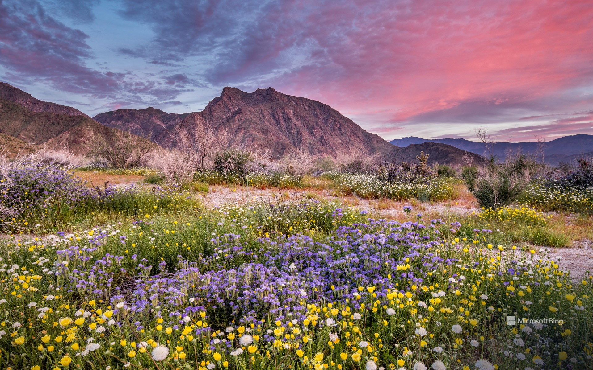
安沙波利哥沙漠州立公园,美国加利福尼亚州 Anza-Borrego Desert State Park, California (© Stephen Matera/Tandem Stills + Motion)
一抹春色 Where is this colorful desert?
安沙波利哥沙漠州立公园,美国加利福尼亚州
也许距离春天伊始还有好些天,但是加州最大的州立公园——安沙波利哥沙漠州立公园的野花已经在这里向你问好了!每年春天,这片贫瘠的沙漠都会经历一次戏剧性的改变。向日葵、沙漠菊和蒲公英等花朵竞相绽放,形成色彩斑斓的奇观。对于那些想要寻求更多冒险体验的游客来说,从半岛山脉仙人掌丛生的丘陵到峡谷、荒地和天然棕榈绿洲,这个公园有很多可供选择的地方。此外,作为指定的国际黑暗天空公园,这里还是绝佳的观星地点。除了自然奇观之外,占地超过60万英亩的公园还拥有丰富的文化和历史遗产,如古老的象形文字或岩画。
Anza-Borrego Desert State Park, California
The first day of spring may be just days away, but the season's wildflowers at California's largest state park—Anza-Borrego Desert State Park—are already here to say hello! Every spring, this barren desert floor undergoes a dramatic makeover. Flowers like heliotrope, brittlebush, and desert dandelion burst into a riot of bloom, creating a spectacle of color. For those seeking a more adventurous experience, this park has a lot to offer—from the mountains of the Peninsular Ranges and cactus-studded hills to slot canyons, badlands, and natural palm oases. In addition, as a designated International Dark Sky Park, it is an exceptional spot for stargazing. Beyond its natural wonders, the park, spanning over 600,000 acres, is also home to a rich cultural and historical legacy, including ancient pictographs, or rock paintings, from the Native American tribes that once lived here.
布莱斯峡谷国家公园,犹他州,美国 Bryce Canyon National Park, Utah (© Jim Patterson/Tandem Stills + Motion)
布莱斯峡谷国家公园,犹他州,美国 Bryce Canyon National Park, Utah (© Jim Patterson/Tandem Stills + Motion)
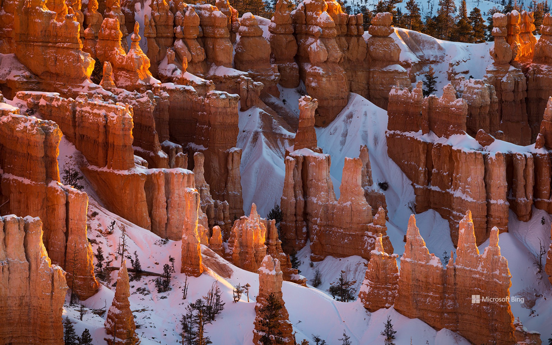
峡谷的守护者 Guardians of the canyo
布莱斯峡谷国家公园,犹他州
徒步是游览犹他州布莱斯峡谷国家公园这些迷人的红色石柱的最佳选择!公园里的徒步小径可以引导您穿行于世界上最大的石柱岩群之间,这些石柱是由侵蚀作用形成的岩石尖顶。这些马蹄形的天然露天剧场会随着阳光的照射而变化,营造出了一种超现实的景观。该地区最初居住着美洲原住民部落,包括派尤特人。虽然没有证据表明他们曾在此长期居住,但派尤特族印第安人曾利用庞沙冈特高原进行季节性狩猎和采集。布莱斯峡谷于1928年被指定为国家公园,峡谷内分布着多个观景点,如灵感点、约文帕点和彩虹点,可将周围的景致尽收眼底。
Bryce Canyon National Park, Utah
These fascinating red hoodoos of Bryce Canyon National Park in Utah are best explored on foot! The park's hiking trails guide you among the world's largest collection of hoodoos, which are rock spires formed by erosion. The horseshoe-shaped natural amphitheaters create a surreal landscape that changes with the play of sunlight. The area was initially inhabited by Native American tribes, including the Paiute people. Although there is no evidence of them having lived there permanently, Paiute Indians used the Paunsaugunt Plateau for seasonal hunting and gathering. Designated a national park in 1928, Bryce Canyon is dotted with several viewpoints like Inspiration Point, Yovimpa Point, and Rainbow Point, which offer panoramic vistas of the surrounding topography.
比斯第恶土,新墨西哥州,美国 Bisti/De-Na-Zin Wilderness Area, New Mexico (© Ian Shive/Tandem Stills + Motion)
比斯第恶土,新墨西哥州,美国 Bisti/De-Na-Zin Wilderness Area, New Mexico (© Ian Shive/Tandem Stills + Motion)
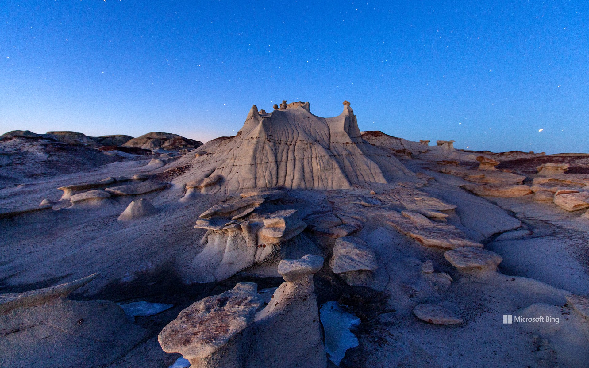
因时间而改变 Transformed by time
新墨西哥州比斯第恶土
时间是伟大的变革者,它改变着世界,也改变着我们所有人。例如,新墨西哥州的这片名为比斯第恶土的荒地,曾经是一片郁郁葱葱的热带森林。近7000万年前,这里没有扭曲的地形和高耸的尖塔,而是一群白垩纪晚期恐龙的家园,包括甲龙、鸭嘴龙和强大的霸王龙。如今,这里到处都是另一种奇观,岩层看起来更像是雕塑,而不是自然现象。比斯第恶土的名字“Bisti/De-Na-Zin”是以纳瓦霍语命名的:“Bisti” 的意思是 "在土坯岩层中",“De-Na-Zin” 则来自附近的 "站立的仙起重机"石刻。来到四角地区的游客一定不要错过这片由页岩和砂岩组成的超凡脱俗的景观。
Bisti/De-Na-Zin Wilderness, New Mexico
Time is the great transformer, changing the world and all of us. For instance, this New Mexico badland—the Bisti/De-Na-Zin Wilderness—was once a lush, tropical forest. Nearly 70 million years ago, instead of twisted terrains and towering spires, this place was home to an array of Late Cretaceous dinosaurs, including armored Ankylosaurs, duck-billed Hadrosaurs, and mighty Tyrannosaurs. Today, the area is filled with wonders of a different kind, rock formations that look more like sculptures than natural phenomena. Bisti/De-Na-Zin is named after Navajo words: Bisti means 'among the adobe formations,' and De-Na-Zin means 'standing crane,' a reference to nearby rock carvings of the bird. Visitors to the Four Corners region shouldn't miss out on this otherworldly landscape of shale and sandstone.