标签 美国 下的文章
1990年纽约市马拉松比赛,参赛者穿过韦拉扎诺海峡大桥 Runners in the 1990 New York City Marathon crossing the Verrazzano-Narrows Bridge (© David Madison/Getty Images)
1990年纽约市马拉松比赛,参赛者穿过韦拉扎诺海峡大桥 Runners in the 1990 New York City Marathon crossing the Verrazzano-Narrows Bridge (© David Madison/Getty Images)
跑过纽约五个行政区 Racing through the five boroughs
韦拉扎诺海峡大桥
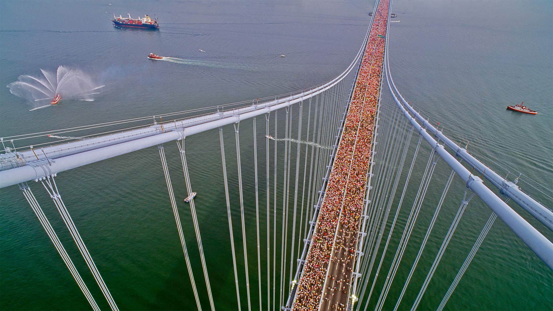
2022年纽约市马拉松赛的路线就从这里开始,在韦拉扎诺海峡大桥,从斯塔顿岛(Staten Island)穿过布鲁克林(Brooklyn),最终穿过纽约的五个自治区。这张照片让你知道今天将有多少人跑步。因为比赛在11月的一个早晨很早就开始了,许多跑步者都穿着分层的衣服来抵御典型的寒冷。但一旦它们从跑步中升温,这些层就会脱落,经常被丢弃在人行道上。比赛组织者收集每年约26吨的遗留下来的运动装备,并将其捐赠给慈善机构。
Verrazzano-Narrows Bridge
The route for the 2022 New York City Marathon starts right here at the Verrazzano-Narrows Bridge, crossing from Staten Island into Brooklyn, eventually coursing through all five boroughs of New York. This photo gives you an idea of just how many people will be running today. Because the race starts early on a November morning, many runners show up in layered clothing to beat the typical chill. But once they heat up from running, those layers come off and are often discarded on sidewalks. Race organizers collect the activewear left behind, about 26 tons a year, and donate it to charity.
秋季的落羽杉,美国佐治亚州 Cypress trees in autumn, Georgia (© Chris Moore/Tandem Stills + Motion)
秋季的落羽杉,美国佐治亚州 Cypress trees in autumn, Georgia (© Chris Moore/Tandem Stills + Motion)
美国南部的别样秋景 Leaf-peeping Southern style
乔治亚州的柏树
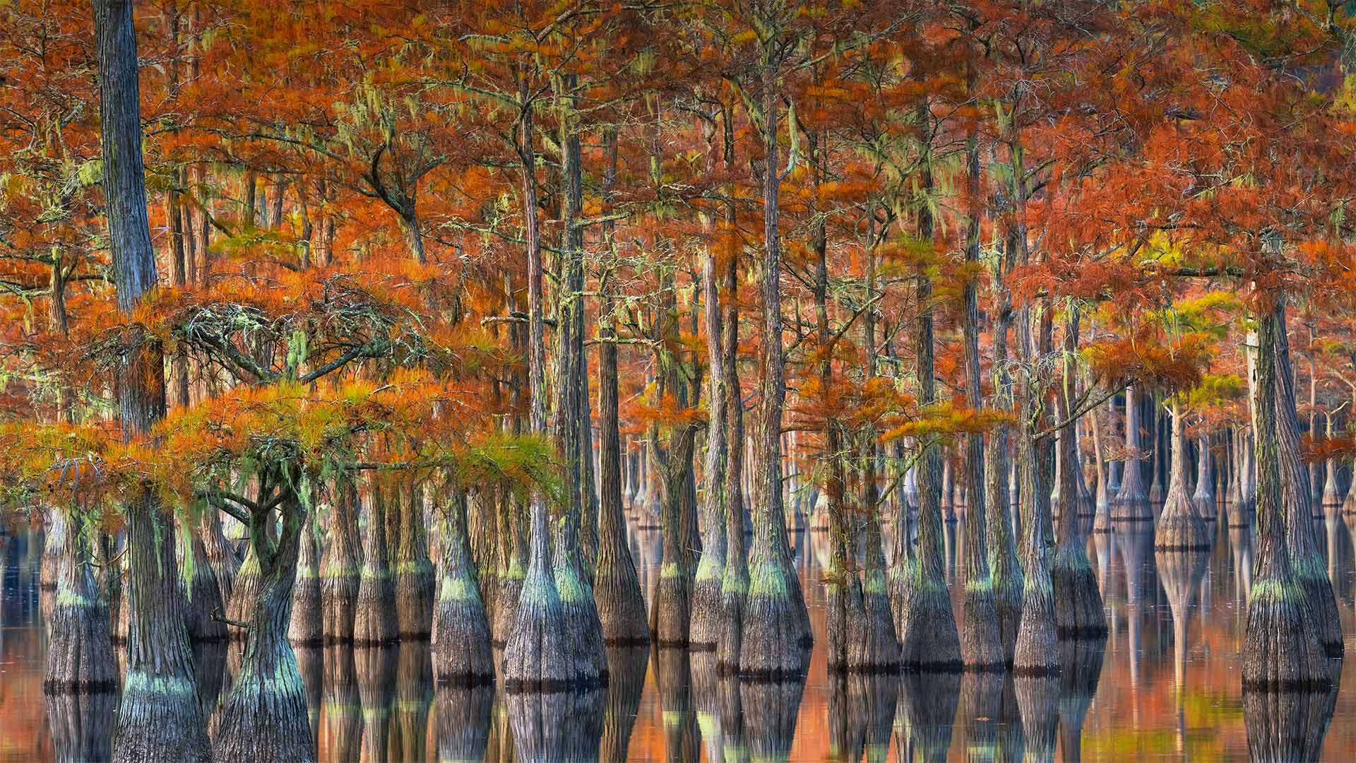
秋天的树叶是秋天的标志,当人们想到法兰绒、灯芯绒、南瓜香料和其他东西时。阳光明媚的白天和清爽的夜晚邀请我们走出去欣赏树叶的颜色变化。虽然有些人可能认为新英格兰的枫树是窥视树叶的金标准,但其他人则会把奖品授予落基山脉的白杨或南方的柏树。
佐治亚州的这些秃顶柏树变成了明亮的金色、橙色和深红色,与北方的竞争对手相媲美。大多数种类的柏树都是常绿的,但秃顶的柏树是落叶的,它们的花边针叶在秋天变成鲜艳的铜色,在冬天秋天,然后树木在春天长出一套新的针叶。秃柏原产于美国东南部,在墨西哥湾沿岸的密西西比河流域盛产。它们在路易斯安那州的河口是一个熟悉的景象,也生长在大西洋中部的沿海平原,就像这片帝王林。秃柏树在河岸和沼泽等潮湿条件下茁壮成长。这些生长缓慢的植物通常高达100英尺以上,为两栖动物、鱼类和鸟类提供了重要的栖息地,并保护海岸线免受侵蚀和洪水。如果你在一年中的这个时候来到这个地区,在温和的巨人们脱掉秋季服装之前,前往沼泽地观看秋季展览。
Bald cypress trees in Georgia
Fall foliage is the hallmark of autumn, when thoughts turn to flannel and corduroy, pumpkin spice and s'mores. Sunny days and crisp nights invite us to step outside to enjoy the changing colors of the leaves. While some may consider the maples of New England the leaf-peeping gold standard, others would give the prize to the aspens of the Rocky Mountains or the cypress trees of the South.
These bald cypress trees in Georgia turn brilliant shades of gold, orange, and crimson that rival their northern competitors. Most varieties of cypress are evergreen, but bald cypresses are deciduous—their lacy needles turn this vibrant copper color in autumn, fall in winter, then the trees grow a new set of needles in the spring. Bald cypresses are native to the southeastern US and flourish in the Mississippi River basin along the Gulf Coast. They're a familiar sight in the bayous of Louisiana and also grow in the coastal plains of the mid-Atlantic, like this regal grove. Bald cypresses thrive in wet conditions like riverbanks and swamps. Commonly reaching well over 100 feet tall, these slow growers provide important habitat for amphibians, fish, and birds, and they protect coastlines from erosion and flooding. If you're in the area this time of year, head to the swamp to see the autumn display before the gentle giants shed their fall outfits.
楚科奇海的浮游植物水华,美国阿拉斯加州海岸附近 Blooms of phytoplankton in the Chukchi Sea off the coast of Alaska (© Norman Kuring/Kathryn Hansen/U.S. Geological Survey/NASA)
楚科奇海的浮游植物水华,美国阿拉斯加州海岸附近 Blooms of phytoplankton in the Chukchi Sea off the coast of Alaska (© Norman Kuring/Kathryn Hansen/U.S. Geological Survey/NASA)
什么生长得这样茂盛? What's blooming so brightly?
楚科奇海浮游植物的大量繁殖
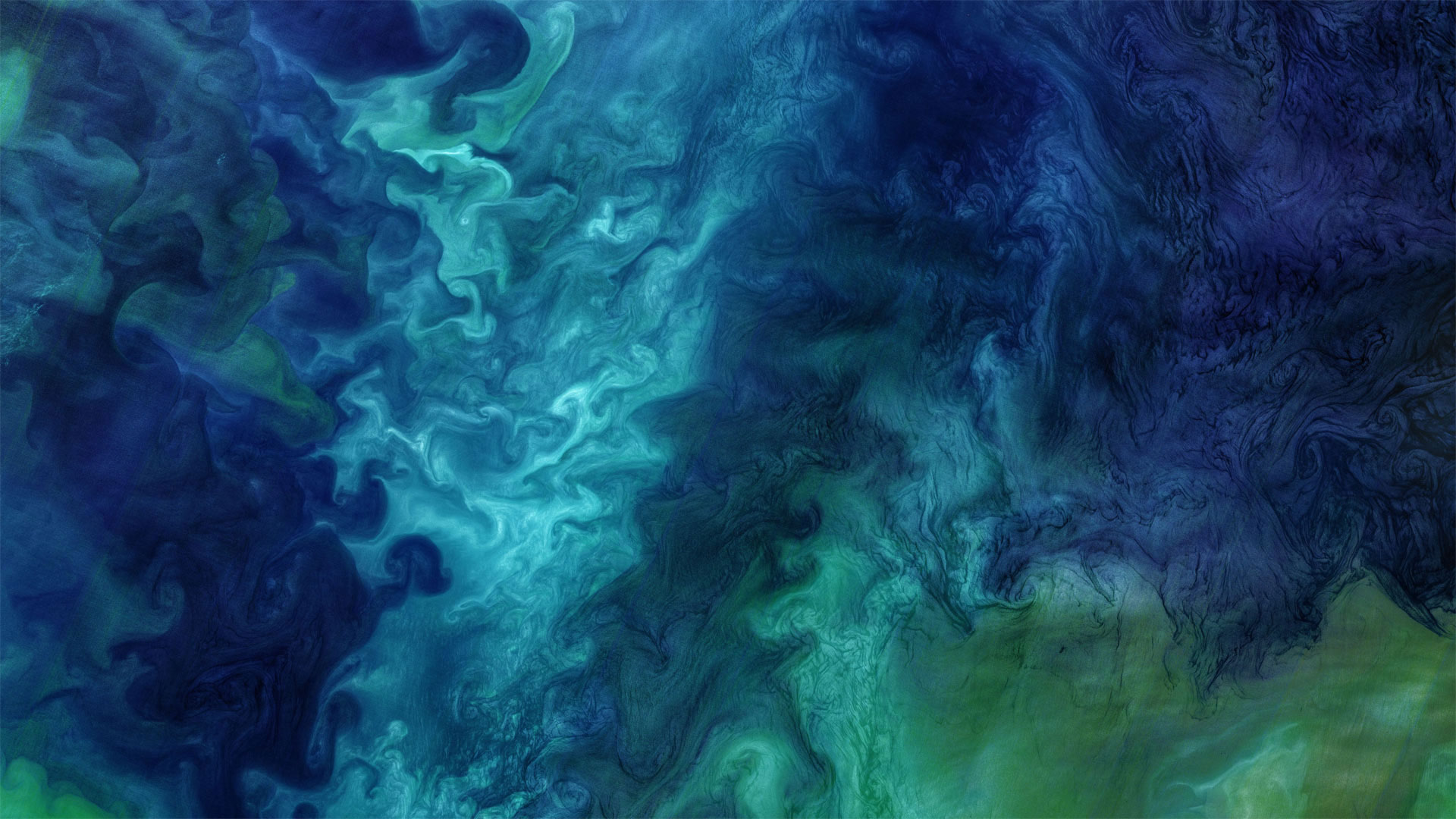
在这张酷酷的照片中,数百种深浅的蓝色被大理石镶嵌在一起。不,这不是一件现代艺术作品,它是大自然的杰作。这是一张卫星照片,照片中的浮游植物在阿拉斯加附近盛开,凉爽、咸的楚科奇海与靠近海岸的温暖、新鲜的海水混合在一起。
但究竟什么是浮游植物?它们是微小的太阳能生物,漂浮在海面附近,随洋流漂流。事实上,它们的名字来源于希腊语中植物的“phyton”和流浪者或漂泊者的“planktos”。对于生活在海洋和河口的各种生物来说,浮游植物既美味又营养,对地球上的每一个人都至关重要:浮游植物的光合作用约占世界光合作用的一半,是吸收二氧化碳和释放氧气的太阳能过程。
今天我们谈论浮游植物是为了纪念地球科学周,这是一个鼓励我们所有人学习甚至献身于地球科学的国际活动。今年的主题是“地球科学促进可持续发展世界”,强调科学在维持我们的星球上的作用。所以,是时候掸掉显微镜上的灰尘,参观当地的科学博物馆,或者也许只是了解更多关于美丽的旋转浮游植物的知识。
Blooms of phytoplankton in the Chukchi Sea
Hundreds of shades of blue are marbled together in this cool shot. No, it's not a work of modern art, it's right off the brush of nature. This is a satellite photo of phytoplankton blooming near Alaska as the cool, salty Chukchi Sea mingles with warmer, fresher water closer to shore.
But just what are phytoplankton? They're microscopic sun-powered organisms that float near the surface of the ocean, drifting with the currents. In fact, their name derives from the Greek 'phyton' for plant and 'planktos' for wanderer or drifter. Delicious and nutritious to various creatures living in oceans and estuaries, they're also vital to everyone on Earth: Phytoplankton are responsible for about half of the world's photosynthesis, the sun-powered process that takes in carbon dioxide and releases oxygen.
We're talking phytoplankton today in honor of Earth Science Week, an international event encouraging all of us to learn about or even devote our life to the Earth sciences. This year's theme is 'Earth Science for a Sustainable World,' emphasizing science's role in sustaining our planet. So, time to dust off that microscope, visit your local science museum, or perhaps just learn more about beautiful, swirling phytoplankton.
卡伯特镇的福斯特廊桥,美国佛蒙特州 Foster Covered Bridge in Cabot, Vermont (© Alan Majchrowicz/Getty Images)
卡伯特镇的福斯特廊桥,美国佛蒙特州 Foster Covered Bridge in Cabot, Vermont (© Alan Majchrowicz/Getty Images)
一场现代化的重建 A modern recreation
The A.M. Foster covered bridge in Cabot, Vermont
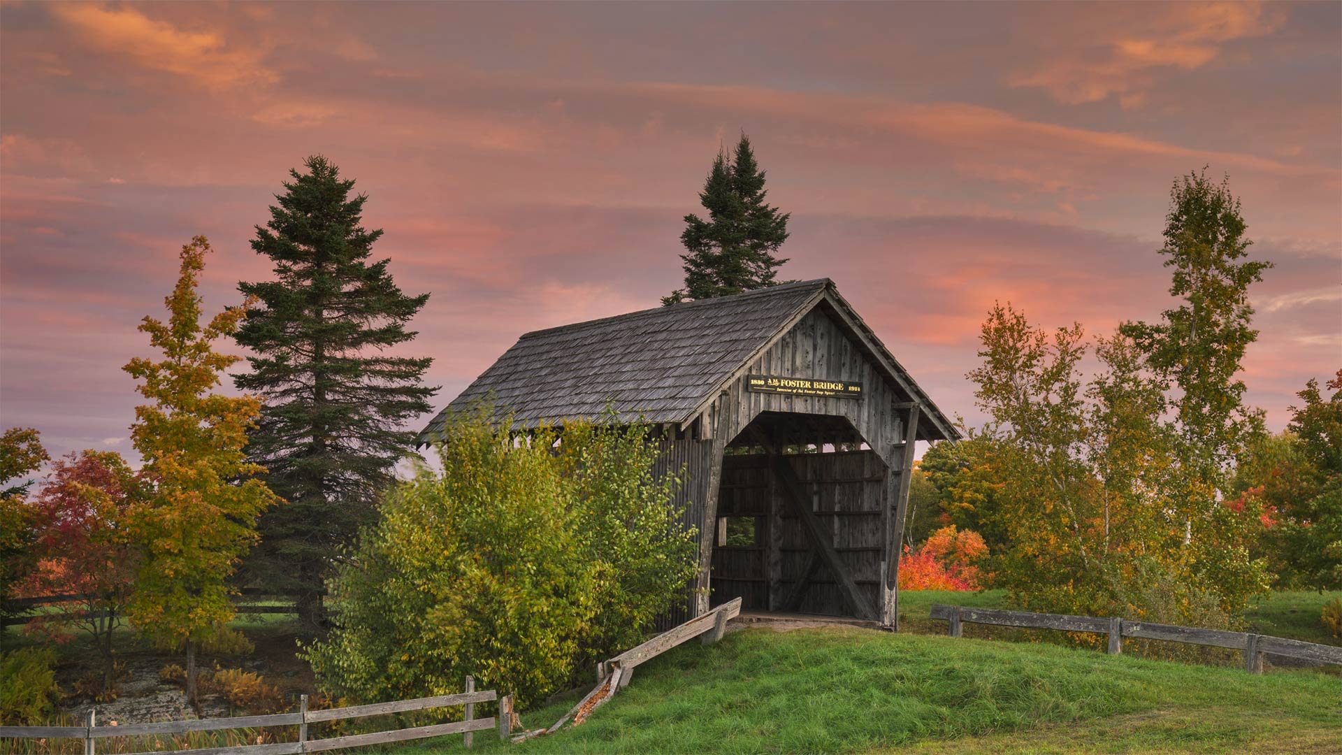
At one point in history, the United States had upwards of 14,000 wooden covered bridges. Most of them were built between 1825 and 1875 to cross a stream or river and were intended to withstand the elements. An uncovered wooden bridge may have a lifespan of only about 20 years while a covered bridge could stand for more than a 100. Even still, they don't fare well without upkeep and restoration costs can be high. Iron replaced wood as the preferred and cheaper bridge-building material in the mid-1800s. These days, fewer than 900 of the original wooden covered bridges are believed to still be standing. Vermont currently has 104 of them, the highest density of remaining covered bridges in the country. The Alonzo Merrill Foster covered bridge seen in today's photo can be found in Cabot, Vermont.
The A.M. Foster bridge, named after the inventor of a type of maple spout, is located on Spaulding Farm. Don't be deceived, the Foster bridge is actually a 1990s replica of a 'farm bridge' that was built in 1890 known as the Orton Bridge. Despite being a replica, the Foster bridge was authentically constructed by hand, in collaboration with Foster's great-grandson, with spruce lumber and salvaged granite. Spanning 45 feet across a man-made pond and literally bridging the gap between two farms, it took less than 6 weeks to complete. Unfortunately, it was found to be too narrow for modern farm equipment, a miscalculation that its constructors found amusing. Still, it works well as a photo opportunity and frequent venue for weddings.
佛蒙特州卡博特的福斯特廊桥
在历史上的某个时期,美国有超过14000座木桥。这些建筑大多建于1825年至1875年之间,用于跨越溪流或河流,旨在抵御恶劣天气。一座无遮盖的木桥可能只有大约20年的寿命,而一座有遮盖的桥可以支撑100多年。即使如此,如果没有维护,它们也不会很好,修复成本可能很高。19世纪中叶,铁取代木材成为首选且更便宜的桥梁建筑材料。这些天来,据信只有不到900座原始的木制覆盖桥梁仍然屹立着。佛蒙特州目前有104座桥,是该国剩余有盖桥梁密度最高的一座。今天照片中的阿隆佐-梅里尔-福斯特(Alonzo Merrill Foster)桥位于佛蒙特州的卡伯特(Cabot)。
A.M.Foster桥位于斯波尔丁农场,以一种枫树喷口的发明者命名。别被骗了,福斯特桥实际上是一座建于1890年的“农场桥”的90年代复制品,被称为奥尔顿桥。尽管是一座复制品,但福斯特桥确实是与福斯特的曾孙合作,用云杉木材和回收的花岗岩手工建造的。它横跨一个45英尺长的人工池塘,实际上弥补了两个农场之间的差距,不到6周就完成了。不幸的是,对于现代农业设备来说,它太窄了,这是一个让建造者感到有趣的错误计算。尽管如此,作为一个拍照机会和频繁举行婚礼的场所,它仍然很管用。
黄石国家公园里的上间歇泉盆地,美国怀俄明州 Upper Geyser Basin in Yellowstone National Park, Wyoming (© Ray Urner/Tandem Stills + Motion)
黄石国家公园里的上间歇泉盆地,美国怀俄明州 Upper Geyser Basin in Yellowstone National Park, Wyoming (© Ray Urner/Tandem Stills + Motion)
水与火相遇的地方 Where fire and water meet
Upper Geyser Basin, Yellowstone National Park
The highest concentration of geysers and hydrothermal springs in the world are located here in this corner of Yellowstone National Park, called the Upper Geyser Basin. They include what is perhaps the most famous geyser of them all: Old Faithful. But the Upper Basin contains many other geysers as well, including the tallest predictable geyser (Grand Geyser) and the most voluminous geyser (Giant Geyser). Yellowstone contains about 300 geysers, about two-thirds the number in the entire world.
Geysers are essentially a rare form of hot spring—a water-filled tube that extends thousands of feet into the Earth's crust, so deep it makes contact with molten rock called magma. The water in the tube boils and under extreme pressure ejects the water column into the air, emptying the tube. After some time, more groundwater seeps into the tube, filling it, and starting the process over again. That's why geysers erupt at somewhat regular intervals. The bigger the tube, the more water, and the longer the eruption. Yellowstone is one of the few places in the world where you can safely walk among so many geysers and superheated springs, and view them close up. Trails and boardwalks guide the way, making the Upper Geyser Basin one of the star attractions of this famous national park.
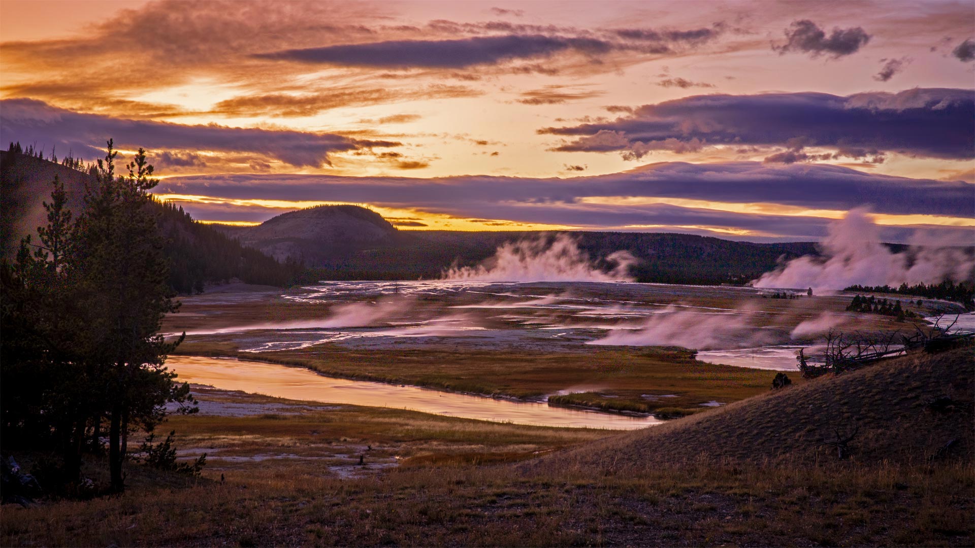
黄石国家公园上间歇泉盆地
世界上最密集的间歇泉和热泉位于黄石国家公园的这个角落,被称为上间歇泉盆地。其中最著名的喷泉可能是:老忠实喷泉。但上盆地也有许多其他间歇泉,包括最高的可预测间歇泉(大间歇泉)和最大的间歇泉(巨型间歇泉)。黄石公园有大约300个间歇泉,大约是全世界的三分之二。
间歇泉本质上是一种罕见的温泉,它是一种充满水的管子,伸入地壳数千英尺深,与称为岩浆的熔融岩石接触。管子中的水沸腾,在极端压力下将水柱喷射到空气中,排空管子。一段时间后,更多的地下水渗入管道,将其充满,然后重新开始这一过程。这就是间歇泉每隔一定时间喷发的原因。管子越大,水越多,喷发时间越长。黄石公园是世界上为数不多的几个可以在众多间歇泉和过热泉水之间安全漫步并近距离观看的地方之一。小径和木板人行道指引着道路,使上间歇泉盆地成为这个著名国家公园的明星景点之一。
两头穿越苏西特纳河的驯鹿,美国阿拉斯加 Caribou crossing the Susitna River during the autumn rut, Alaska (© Tim Plowden/Alamy)
两头穿越苏西特纳河的驯鹿,美国阿拉斯加 Caribou crossing the Susitna River during the autumn rut, Alaska (© Tim Plowden/Alamy)
令人印象深刻的时刻 Time to make an impression
Caribou rutting season in Alaska
It's that time of year when Alaskan caribou are beginning to feel a little frisky. From late September until early November, males will be strutting their stuff, locking antlers with one another, and competing for the attention of females in hopes of furthering the species. Successful males will mate with 15-20 females a season. After the rutting season males will shed their antlers while females keep theirs until spring. In today's photo we're looking at some caribou in southcentral Alaska crossing the Susitna River.
Alaska has 32 distinct caribou herds. It's likely today's caribou are members of the Nelchina herd, which roams across about 20,000 square miles in the high basin surrounded by the Talkeetna, Chugach, Wrangell, and Alaska ranges. The Nelchina herd is among the most studied and recognized of Alaskan caribou partly because their range is relatively close to the major human population centers of the state. The herd has provided food for Alaskans for hundreds of years and its population is maintained through carefully monitored hunting regulations. But caribou populations can fluctuate from one year to the next depending on the availability of food and severity of the weather.
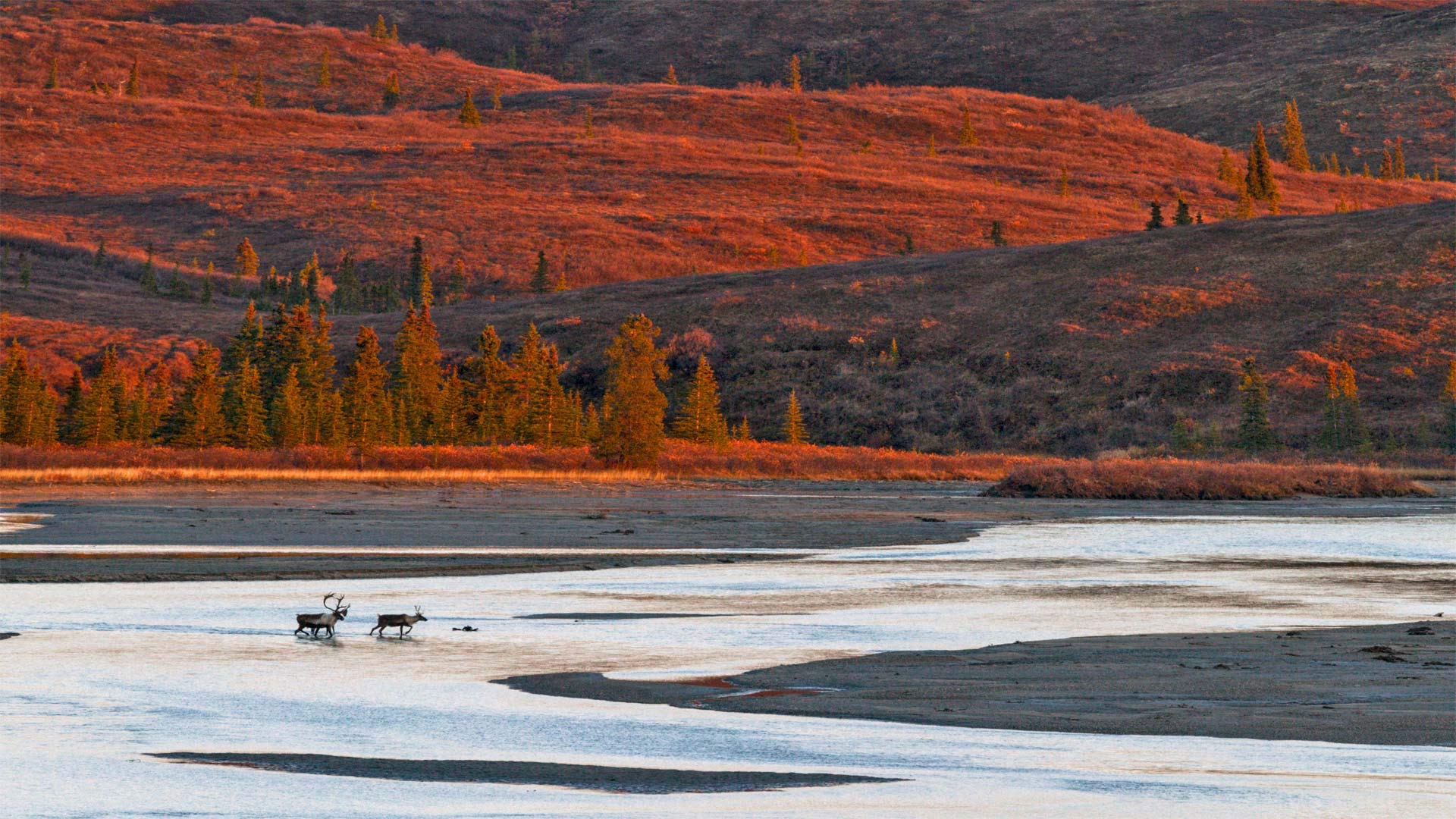
阿拉斯加驯鹿发情季节
每年的这个时候,阿拉斯加驯鹿开始感到有点活泼。从9月下旬到11月初,雄性将昂首阔步,相互锁住鹿角,争夺雌性的注意力,以期进一步丰富物种。成功的雄性每季度将与15-20只雌性交配。发情期过后,雄性会脱掉鹿角,而雌性会一直保留到春天。在今天的照片中,我们看到一些驯鹿在阿拉斯加中南部穿越苏西特纳河。
阿拉斯加有32个不同的驯鹿群。今天的北美驯鹿很可能是Nelchina鹿群的成员,它们在塔基特纳山脉、楚加赫山脉、朗格尔山脉和阿拉斯加山脉环绕的高盆地中漫游,占地约20000平方英里。Nelchina驯鹿群是阿拉斯加驯鹿中研究和认识最多的驯鹿群之一,部分原因是它们的分布范围相对接近该州的主要人口中心。数百年来,牧群一直为阿拉斯加人提供食物,通过仔细监测狩猎法规来维持种群数量。但是驯鹿的数量可能会随着食物的供应和天气的恶劣程度而在一年到另一年之间波动。
阿卡迪亚国家公园上空的银河系,美国缅因州 Milky Way over Acadia National Park, Maine (© Harry Collins/Getty Images)
阿卡迪亚国家公园上空的银河系,美国缅因州 Milky Way over Acadia National Park, Maine (© Harry Collins/Getty Images)
繁星闪烁的夜晚 Starry, starry night
Acadia National Park, Maine
This striking photo lets us showcase two noteworthy events in one day, at no extra charge. (You’re welcome.) National Public Lands Day is observed on the fourth Saturday in September, and today’s also part of the Acadia Night Sky Festival, which celebrates the starlit skies over Maine’s gem of a national park.
It’s easy to take our national parks for granted. We certainly appreciate them and enjoy visiting, but today’s commemoration reminds us that they also need our help. National Public Lands Day turns the spotlight on parks and other public lands, inviting everyone to explore but also to volunteer to plant trees, work on trail-maintenance projects, and more. As a bonus: Admission is free today at national parks, monuments, and other participating federal sites.
Acadia is one of the smallest of the nation's 63 national parks, though it attracts an impressive 3 million visitors a year. Aside from its natural beauty, Acadia has some of the most spectacular star-filled night skies in the eastern United States. The natural darkness is protected, with restrictions on outdoor lighting in the park and surrounding areas. The Acadia Night Sky Festival, which started on September 21 and continues through tomorrow, celebrates the natural darkness and the celestial star show. A favorite way to mark the occasion is by kayaking in Castine's harbor, where bioluminescent phytoplankton illuminate the water with a swirling, unearthly glow. With sparkling waters below and out-of-this-world stargazing above, it's been called Acadia's 'Floating Planetarium.'
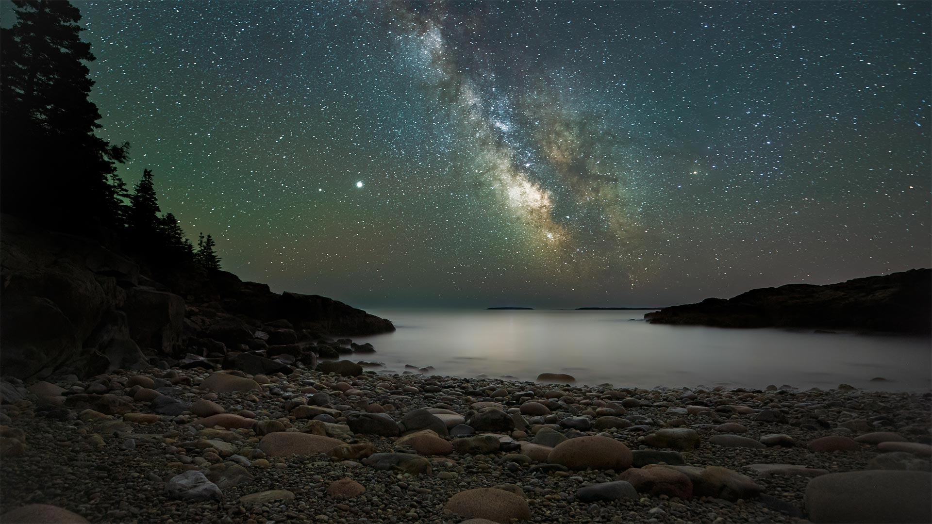
缅因州阿卡迪亚国家公园
这张引人注目的照片让我们可以在一天内免费展示两件值得关注的事件。(不客气。)9月的第四个星期六是国家公共土地日,今天也是阿卡迪亚夜空节的一部分,庆祝缅因州国家公园瑰宝上星光灿烂的天空。
我们很容易把国家公园视为理所当然。我们当然很感激他们,也很喜欢参观,但今天的纪念活动提醒我们,他们也需要我们的帮助。国家公共土地日将聚光灯转向公园和其他公共土地,邀请每个人探索,也自愿植树,从事小径维护项目等。作为奖励:国家公园、纪念碑和其他参与的联邦网站今天免费入场。
阿卡迪亚是美国63个国家公园中最小的一个,尽管每年吸引了300万游客。除了它的自然美景,阿卡迪亚还有一些美国东部最壮观的充满星星的夜空。自然黑暗受到保护,公园和周边地区的室外照明受到限制。阿卡迪亚夜空节于9月21日开始,持续到明天,庆祝自然的黑暗和天上的星星表演。最受欢迎的庆祝方式是在卡斯廷港划独木舟,在那里,生物发光的浮游植物以漩涡般的、超自然的光芒照亮水面。它的下面和外面都是波光粼粼的海水,俯瞰着天空,被称为阿卡迪亚的“浮动天文馆”。
大理石峡谷中横跨科罗拉多河的纳瓦霍桥,美国亚利桑那州北部 Marble Canyon bridges over the Colorado River at the Glen Canyon National Recreation Area in northern Arizona (© trekandshoot/Alamy)
大理石峡谷中横跨科罗拉多河的纳瓦霍桥,美国亚利桑那州北部 Marble Canyon bridges over the Colorado River at the Glen Canyon National Recreation Area in northern Arizona (© trekandshoot/Alamy)
横跨峡谷裂缝的两座桥 Bridging the gap two ways
Happy birthday, bridges
Today we're taking a trip to a part of northern Arizona cut off from the rest of the state by the Colorado River and its deep canyons. No doubt you've heard of the Grand Canyon, but today is an important milestone to another canyon about 70 miles away. On this date in 1995, the twin Marble Canyon bridges, better known collectively as Navajo Bridge, were officially dedicated as the second bridge was installed.
The first, in place since 1929 when it was hailed as a 'modern marvel' and 'the biggest news in Southwest history,' had long been key to travel across the 834-foot gap of Marble Canyon. But as time passed, the area saw heavier vehicles and more traffic. After much debate about the impact on Native land and endangered plants, and the likelihood of debris falling into the river below, plans were developed for the $14.7 million, nearly identical second bridge. Now, Marble Canyon has two bridges, each about 470 feet over the Colorado River. The original serves as a path for humans and horses while the new bridge carries vehicles. Both bridges hold the title of ninth-highest in the United States (though the newer one is about three feet higher).
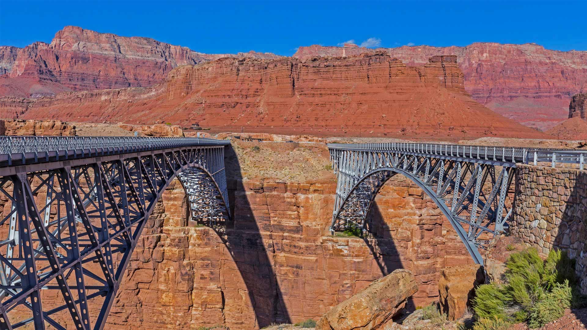
生日快乐,桥
今天,我们将前往亚利桑那州北部的一个地区,那里被科罗拉多河及其深峡谷与该州的其他地区隔绝。毫无疑问,你听说过大峡谷,但今天是70英里外另一个峡谷的重要里程碑。1995年的这一天,两座大理石峡谷大桥(合称纳瓦霍桥)正式投入使用,第二座大桥也安装完毕。
自1929年被誉为“现代奇迹”和“西南历史上最大的新闻”以来,第一条铁路一直是穿越834英尺高的大理石峡谷的关键。但随着时间的推移,该地区的车辆越来越重,交通也越来越多。在对当地土地和濒危植物的影响以及碎片落入河流的可能性进行了大量辩论后,为价值1470万美元、几乎相同的第二座桥梁制定了计划。现在,大理石峡谷有两座桥,每座桥跨越科罗拉多河约470英尺。最初的桥梁是人和马的通道,而新的桥梁则承载车辆。这两座桥都是美国第九高的桥梁(尽管较新的桥高约三英尺)。
大沙丘国家公园和保护区,美国科罗拉多州 Great Sand Dunes National Park and Preserve, Colorado (© Y Paudel/Getty Images)
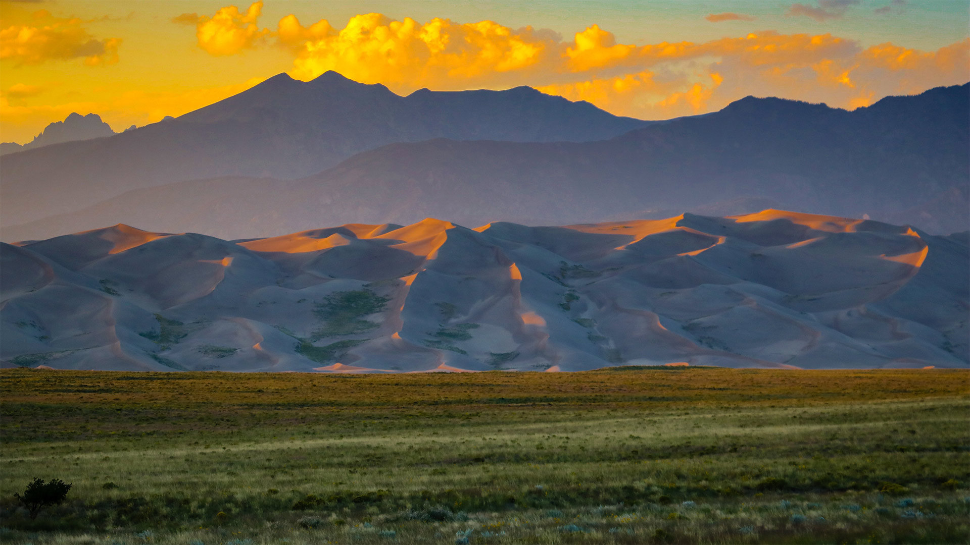
大沙丘国家公园和保护区,美国科罗拉多州 Great Sand Dunes National Park and Preserve, Colorado (© Y Paudel/Getty Images)
如沙漏中的沙子一般 Like sands through the hourglass
Great Sand Dunes National Park and Preserve
Today we celebrate the birthday of Great Sand Dunes National Park and Preserve, which boasts 750-foot (and higher) sand dunes that cover more than 30 square miles. But the towering hills of sand—the tallest in North America—are just one feature of an eye-popping Colorado landscape that includes conifer forests, alpine lakes, and wetlands. The 85,000-acre park and preserve even encompasses stretches of tundra at the higher elevations, where it edges up against the base of the Sangre de Cristo Mountains.
Initially proclaimed a national monument in 1932 by President Herbert Hoover, the territory was redesignated as Great Sand Dunes National Park and Preserve on September 13, 2004, and the size of the park was quadrupled. The park and preserve provide ample and wildly diverse activities for visitors, from sandboarding and sandsledding down the steep dunes to hiking, camping, horseback riding, and fat-tire biking.
大沙丘国家公园和保护区
今天,我们庆祝大沙丘国家公园和保护区(Great Sand Dunes National Park and Preserve)的生日,该保护区拥有750英尺(或更高)的沙丘,面积超过30平方英里。但北美最高的高耸沙山只是科罗拉多州令人瞠目的景观的一个特征,包括针叶林、高山湖泊和湿地。85000英亩的公园和保护区甚至包括高海拔地区的苔原,在那里,它与桑格雷德克里斯托山脉的底部相对。
1932年,赫伯特·胡佛总统首次宣布该地区为国家纪念碑,2004年9月13日,该地区被重新指定为大沙丘国家公园和保护区,公园面积增加了四倍。公园和保护区为游客提供了丰富多样的活动,从在陡峭的沙丘上划沙板和玩沙橇到徒步旅行、露营、骑马和骑自行车。
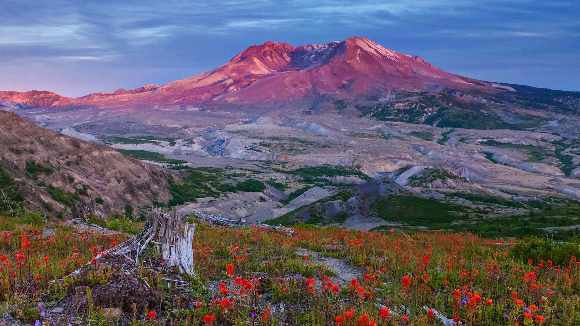
圣海伦斯山国家火山纪念区的边界小径,美国华盛顿州 Boundary Trail in Mount St. Helens National Volcanic Monument, Washington (© Don Geyer/Alamy)
圣海伦斯山国家火山纪念区的边界小径,美国华盛顿州 Boundary Trail in Mount St. Helens National Volcanic Monument, Washington (© Don Geyer/Alamy)
40年的休养生息 40 years of recovery
Mount St. Helens National Volcanic Monument, Washington
Today is an important day in American history. We're standing on the Boundary Trail at Johnston Ridge in the Mount St. Helens National Volcanic Monument. Forty years ago today, 110,000 acres within Gifford Pinchot National Forest was set aside to memorialize the deadliest and most destructive volcanic eruption in the United States. For nearly nine hours on May 18th, 1980, the Mount St. Helens erupted, forever changing the Washington landscape. The volcanic event started at roughly 8:30 on a Sunday morning with a 5.1 magnitude earthquake. This triggered what is known as a 'lateral eruption,' which means the lava blast comes out of the side of the volcano, rather than the top. The initial blast shaved more than a thousand feet off the mountain's elevation, resulting in a massive avalanche and the destruction of about 150 square miles of the surrounding forest. When the event ended, 57 people had died, 200 homes and almost 200 miles of nearby highway had been destroyed.
The monument was established by President Ronald Reagan in 1982 to preserve the area for research, recreation, and education. The land inside has been left to mostly recover naturally since the eruption. While it's believed that Mount St. Helens will erupt again sometime within the next few centuries, that has not deterred people from hiking and climbing at the monument, which has been allowed since 1986.
圣海伦山国家火山纪念碑,华盛顿
今天是美国历史上重要的一天。我们站在圣海伦斯山国家火山纪念碑的约翰斯顿山脊的边界小道上。四十年前的今天,吉福-平肖国家森林内的110000英亩土地被用来纪念美国最致命、破坏性最大的火山爆发。1980年5月18日,圣海伦斯山爆发了近9个小时,永远改变了华盛顿的景观。火山爆发于周日早上8点30分左右,发生了5.1级地震。这引发了所谓的“侧向喷发”,这意味着熔岩喷发从火山的侧面而不是顶部。最初的爆炸使山的海拔下降了一千多英尺,导致了一场大规模的雪崩,并摧毁了周围约150平方英里的森林。活动结束时,57人死亡,200所房屋和近200英里的附近公路被毁。
该纪念碑由罗纳德·里根总统于1982年建立,旨在保护该地区的研究、娱乐和教育。火山爆发后,火山内部的土地基本上自然恢复。虽然人们相信圣海伦斯山将在未来几个世纪的某个时候再次喷发,但这并没有阻止人们前往这座自1986年以来就被允许的纪念碑进行徒步旅行和攀登。