标签 美国 下的文章
灯光璀璨的曼哈顿下城,美国纽约 Lower Manhattan in New York City (© New York On Air/Offset/Shutterstock)

灯光璀璨的曼哈顿下城,美国纽约 Lower Manhattan in New York City (© New York On Air/Offset/Shutterstock)
Manhattan
Ahhh, New York City. Well, Manhattan specifically, one of New York's five boroughs. This aerial view is of Lower Manhattan, what New Yorkers consider the heart of the city. That's New Jersey sparkling across the Hudson River in the distance. And those two bridges pictured on the left are the Brooklyn Bridge (above) and the Manhattan Bridge (below), linking the island of Manhattan to the borough of Brooklyn.
Anytime is the right time to take in the nighttime views of New York City from high above, but the cityscape in January might be especially beguiling. For one thing, you won't have to fight crowds to stand at the windows to view the dazzling lights. May we recommend the observation decks of the Empire State Building, Top of the Rock, and the One World Trade Center Observatory? Happy gazing.
曼哈顿
啊,纽约市。特别是曼哈顿,纽约五个行政区之一。鸟瞰鸟瞰曼哈顿,纽约人认为这座城市的中心。那是新泽西州,在远处的哈德逊河上闪闪发光。左边的两座桥分别是布鲁克林大桥(上图)和曼哈顿大桥(下图),它们将曼哈顿岛与布鲁克林区连接起来。
任何时候都是从高处欣赏纽约市夜景的最佳时机,但一月份的城市景色可能特别迷人。首先,你不必为了站在窗户前观看耀眼的灯光而与人群搏斗。我们可以推荐帝国大厦的观景台、岩石顶观景台和世界贸易中心观景台吗?快乐的凝视。
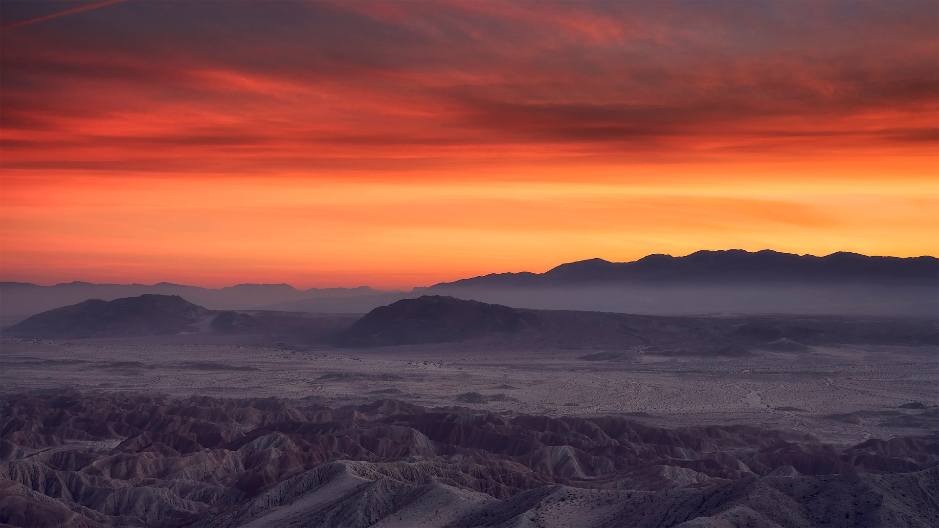
安沙波利哥沙漠州立公园,美国加利福尼亚州 Borrego Badlands in Anza-Borrego Desert State Park, California (© Tom Hogan/plainpicture)
安沙波利哥沙漠州立公园,美国加利福尼亚州 Borrego Badlands in Anza-Borrego Desert State Park, California (© Tom Hogan/plainpicture)
Borrego Badlands
If you're looking to take in a beautiful sunset over some exotic terrain, you could do worse than the Borrego Badlands, a 20-mile stretch of desert in southeastern California's Anza-Borrego Desert State Park. This arid landscape is not the kind of dune-filled terrain t you might visualize when you think of a desert, but a series of rolling hills, canyons, gullies, and arroyos, speckled with sparse but hardy vegetation. It makes for a surreal and beautiful view.
Fossilized seashells found in the area reveal that this arid landscape was once submerged under the waters of the Gulf of California and the Colorado River. The terrain was shaped over time by water and wind erosion into its current form. Today, the Borrego Badlands is a favorite spot for campers, while photographers are drawn by the picture-perfect sunsets.
博雷戈荒地
如果你想在异国情调的地形上欣赏美丽的日落,你可能会比博雷戈荒地(Borrego Badlands)更糟糕。博雷戈荒地位于加利福尼亚州东南部的安扎博雷戈沙漠州立公园(Anza Borrego desert State Park),是一片20英里长的沙漠。这片干旱的土地并不是你想象中的那种布满沙丘的土地,而是一系列起伏的丘陵、峡谷、沟壑和荒野,点缀着稀疏但耐寒的植被。这是一个超现实主义和美丽的景色。
在该地区发现的贝壳化石表明,这片干旱的土地曾被淹没在加利福尼亚湾和科罗拉多河的水域之下。随着时间的推移,地形被水和风侵蚀成现在的形状。今天,博雷戈荒地是露营者最喜欢的地方,而摄影师则被完美的日落所吸引。
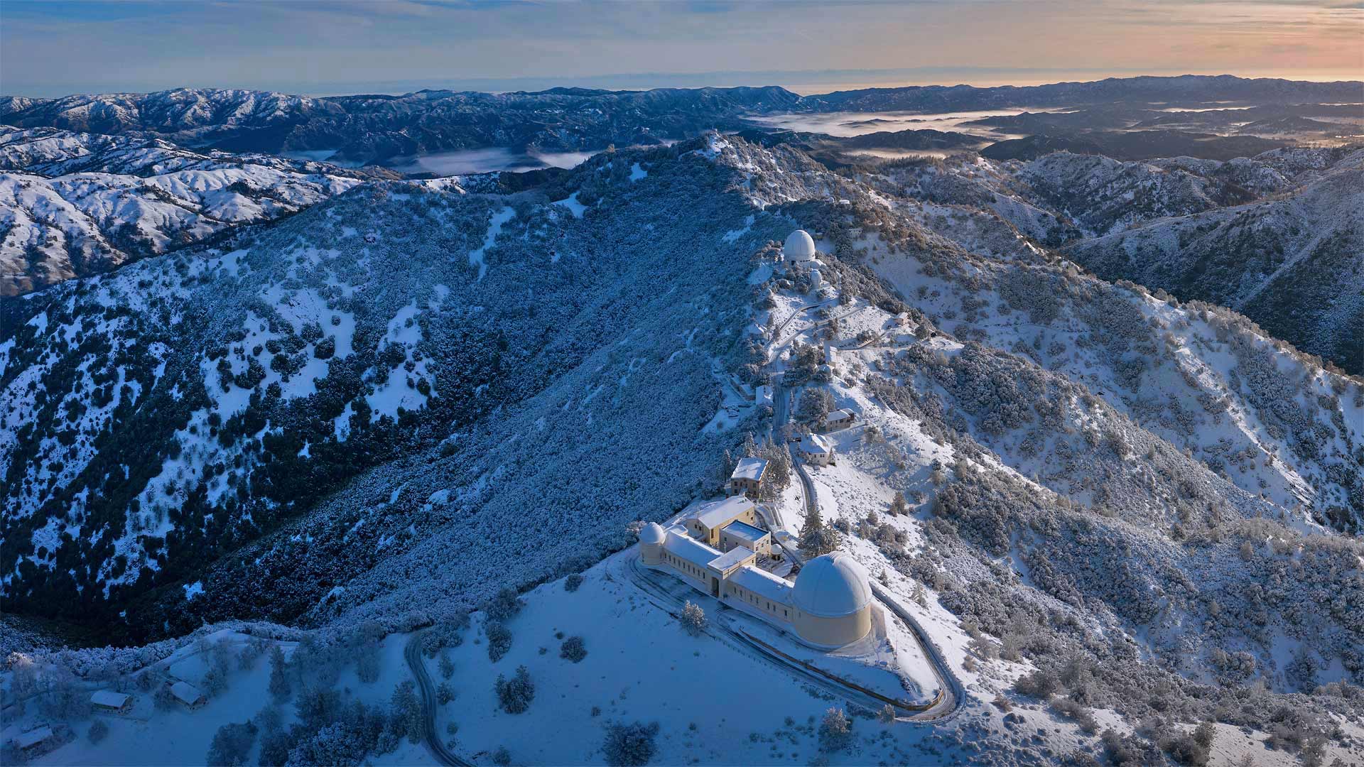
汉密尔顿山顶的利克天文台,美国加利福尼亚州 The Lick Observatory on Mount Hamilton, near San Jose, California (© Jeffrey Lewis/Tandem Stills + Motion)
汉密尔顿山顶的利克天文台,美国加利福尼亚州 The Lick Observatory on Mount Hamilton, near San Jose, California (© Jeffrey Lewis/Tandem Stills + Motion)
Lick Observatory
Shrouded in snow on the summit of Mount Hamilton, in the Diablo Range just east of San Jose, California, lies the world's first permanently occupied mountaintop observatory. Constructed between 1876 and 1887, the Lick Observatory has been the site of significant discoveries including several of Jupiter's moons and other planetary systems. It's named for American real-estate entrepreneur James Lick, who set aside $700,000 for the University of California to build a facility that would be home to a 'telescope superior to and more powerful than any telescope yet made.'
His wish came true. The 36-inch refracting telescope on Mount Hamilton was the largest that had ever been built from when it saw first light on January 3, 1888, until the construction of the 40-inch refractor at Wisconsin's Yerkes Observatory in 1897. Sadly, Lick died before his vision became a reality, but his name lives on. His body is even buried beneath the telescope, which continues to scan the skies today.
利克天文台
在加利福尼亚州圣何塞以东的暗黑破坏神山脉的汉密尔顿山顶上,积雪覆盖着世界上第一座永久性的山顶天文台。建于1876年至1887年间的利克天文台一直是重大发现的地点,其中包括一些木星卫星和其他行星系统。这是以美国房地产企业家James Lick命名的,他为加利福尼亚大学留出了700000美元建造一个设施,它将是一个比任何望远镜都更强大、更强大的望远镜。
他的愿望实现了。汉密尔顿山上的36英寸折射望远镜是从1888年1月3日第一次看到曙光到1897年威斯康星州耶克斯天文台建造40英寸折射望远镜的最大望远镜。可悲的是,利克在他的梦想变成现实之前就去世了,但他的名字却永存。他的尸体甚至被埋在望远镜下面,望远镜今天继续扫描天空。
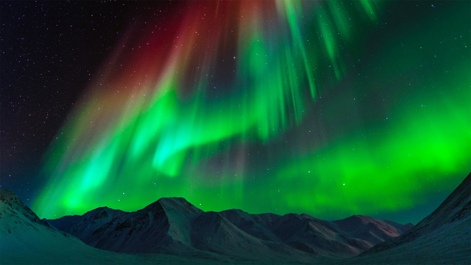
布鲁克斯山脉上空的极光,美国阿拉斯加州 Aurora borealis above the Brooks Range in Alaska (© Noppawat Tom Charoensinphon/Getty Images)
布鲁克斯山脉上空的极光,美国阿拉斯加州 Aurora borealis above the Brooks Range in Alaska (© Noppawat Tom Charoensinphon/Getty Images)
Aurora borealis
You don't have to go all the way to Alaska to see the northern lights (they've been spotted as far south as Hawaii). But based on this stunner of a photo, we recommend it. And the farther north the better: auroras are more frequent and intense the closer you are to the North Pole.
This intense aurora borealis was captured over the Brooks Range, the stretch of mountains that forms the North Slope of Alaska. Journey hundreds of lonely miles northward via the Dalton Highway and you'll descend into a vast coastal plain before finally reaching the Beaufort Sea coast, where nothing but icy water lies between you and the North Pole.
北极光
你不必一路跑到阿拉斯加去看北极光(北极光在南至夏威夷都被发现)。但是基于这张照片的惊人之处,我们推荐它。越北越好:极光越频繁,强度越大,离北极越近。
这种强烈的北极光是在布鲁克斯山脉(Brooks Range)上空拍摄的,布鲁克斯山脉是形成阿拉斯加北坡的山脉。沿着道尔顿公路向北行驶数百英里,你将进入一片广阔的海岸平原,最后到达波弗特海岸,在那里你和北极之间只有冰冷的海水。
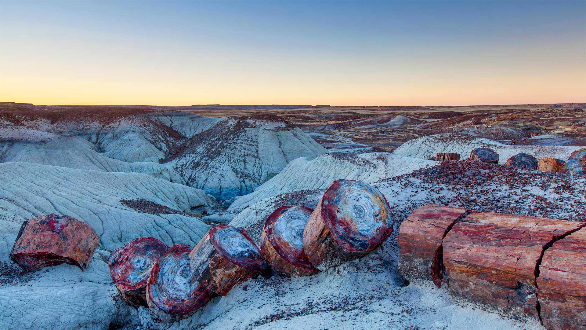
有着丰富石化木材的石化林国家公园,美国亚利桑那州 Petrified Forest National Park, Arizona (© Ian Shive/Tandem Stills + Motion)
有着丰富石化木材的石化林国家公园,美国亚利桑那州 Petrified Forest National Park, Arizona (© Ian Shive/Tandem Stills + Motion)
Petrified Forest National Park
The burliest lumberjack with the best-oiled chainsaw couldn't slice the massive 'timbers' found in Petrified Forest National Park. So why are these giant stone logs segmented in such symmetrical stumps?
Each of these smooth splits occurred in an instant as the brittle quartz cracked under geologic pressure. But each of those instants was eons in the making. First, 225 million years ago, the trees were buried by torrents of river silt. Then mineral deposits slowly seeped into the trees and replaced the decaying wood. Much later, around 60 million years ago, the entire Colorado Plateau began shifting, generating crushing forces that finally divided the petrified logs.
The fossilized trees, surrounding land, and the many plants and animals that live here have enjoyed protection since December 8, 1906, when President Theodore Roosevelt created Petrified Forest National Monument. It was designated as a national park in 1962, lending still greater protection.
石化森林国家公园
最结实的伐木工人和最好的油锯无法切割石化森林国家公园中发现的巨大“木材”。那么,为什么这些巨石原木被分割成如此对称的树桩呢?
当脆性石英在地质压力下破裂时,每一个光滑的裂缝都会在瞬间发生。但是,每一个瞬间都在酝酿中。首先,2.25亿年前,这些树木被河流淤泥的洪流所掩埋。然后,矿物质慢慢渗入树木,取代了腐烂的木材。很久以后,大约6000万年前,整个科罗拉多高原开始移动,产生了最终分裂石化原木的压碎力。
自1906年12月8日西奥多·罗斯福总统创建石化森林国家纪念碑以来,这里的树木化石、周围的土地和许多动植物一直受到保护。1962年,它被指定为国家公园,提供了更大的保护。
海狸湾度假公园, 美国俄克拉何马州 Beavers Bend Resort Park near Broken Bow, Oklahoma (© Inge Johnsson/Alamy)
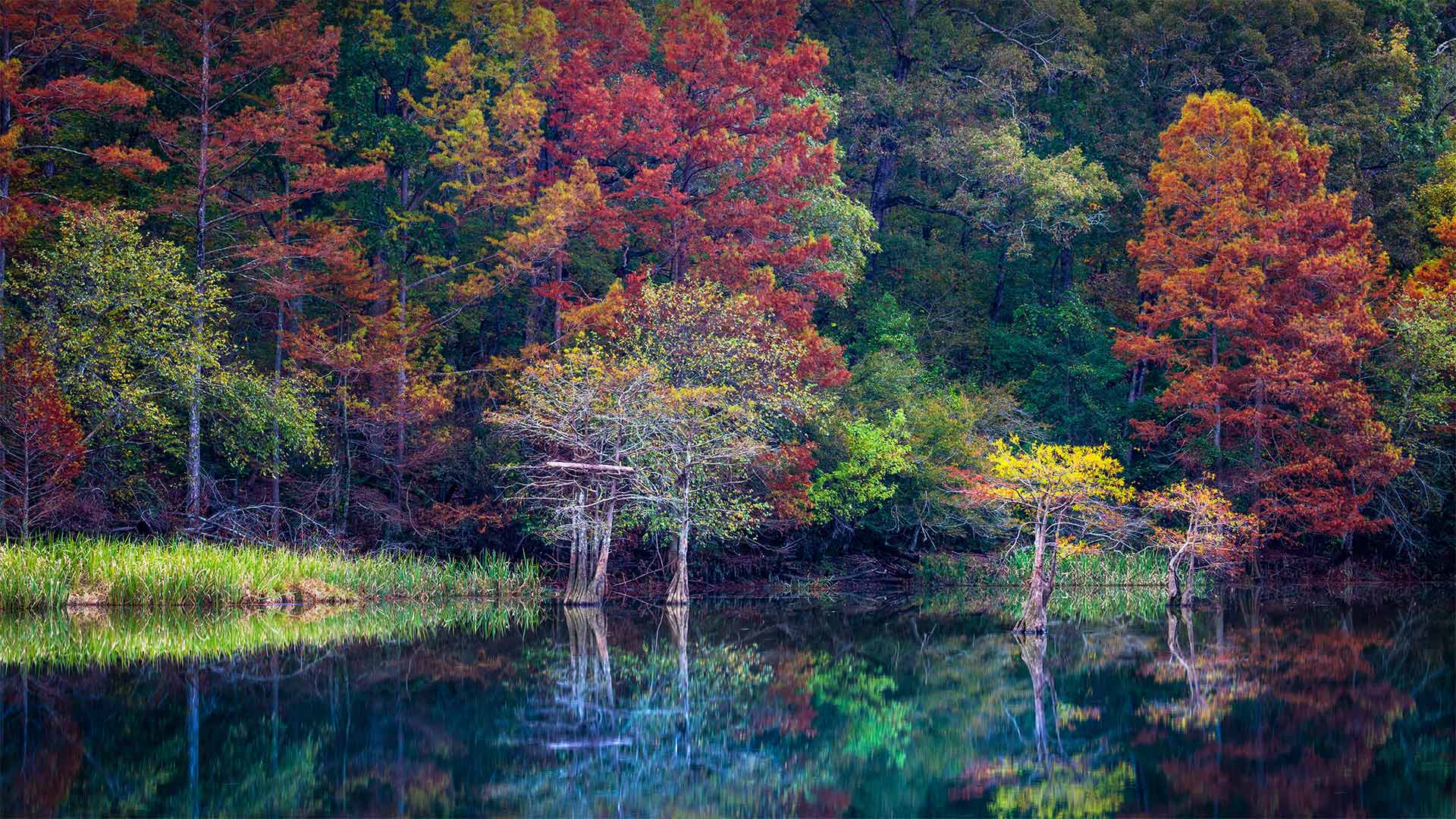
海狸湾度假公园, 美国俄克拉何马州 Beavers Bend Resort Park near Broken Bow, Oklahoma (© Inge Johnsson/Alamy)
Beavers Bend Resort Park
To take in these incredible fall colors, we've come to Beavers Bend State Park, a 1,300-acre wilderness in the southeast corner of Oklahoma. It's a scene that may confound your expectations for the wilds of the 'OK' state. The 'bend' referenced in the park's name is a nearly 180-degree turn in Mountain Fork, the river that runs through the park.
Mountain Fork was dammed to form Broken Bow Lake, which is not just another draw for park visitors interested in water-related recreation but is also used as a reservoir and hydroelectric power generator. To really take in the autumn color in Beavers Bend—or to enjoy it during just about any time of year—there are numerous hiking trails in the park and a train that chugs through some of the park's scenic areas as well.
海狸湾度假村公园
为了欣赏这些令人难以置信的秋天色彩,我们来到了海狸湾州立公园,这是俄克拉荷马州东南角一片1300英亩的荒野。这是一个场景,可能会混淆你对“OK”状态的期望。公园名称中提到的“弯道”是流经公园的河流Mountain Fork的近180度转弯。
Mountain Fork筑坝形成了断头湖,这不仅吸引了对水相关娱乐感兴趣的公园游客,还被用作水库和水力发电机。为了真正欣赏海狸湾的秋色,或者在一年中的任何时候都能欣赏到它,公园里有无数的徒步小径,还有一列火车在公园的一些风景区穿行。
坎伯兰岛国家海岸,美国佐治亚州 Cumberland Island National Seashore, Georgia (© Wilsilver77/Getty Images Plus)
坎伯兰岛国家海岸,美国佐治亚州 Cumberland Island National Seashore, Georgia (© Wilsilver77/Getty Images Plus)
Cumberland Island National Seashore
Along the southernmost stretch of Georgia's Atlantic coast are several barrier islands, and Cumberland is the largest. The US National Park Service (NPS) protects 9,800 acres of the island's wilderness, a place where, as the NPS says, nature and history meet. Human occupation on Cumberland Island touches on numerous milestones in the story of America.
Eventually, Cumberland became a vacation getaway for wealthy industrialists in the 20th century before it became a protected public land.
The natural beauty of the island's maritime forests and marshes add to Cumberland's unique charm. And a lush ecosystem supports the island's diverse array of wildlife, including armadillos, alligators, and herds of feral horses.
州坎伯兰海岸国家公园
沿着乔治亚州大西洋海岸最南端有几个屏障岛,坎伯兰岛是最大的。美国国家公园管理局(NPS)保护着岛上9800英亩的荒野,正如NPS所说,这里是自然和历史交汇的地方。坎伯兰岛上的人类占领涉及到美国历史上的许多里程碑。
最终,坎伯兰在成为受保护的公共土地之前,在20世纪成为富有实业家的度假胜地。
岛上海洋森林和沼泽的自然美景增添了坎伯兰独特的魅力。繁茂的生态系统支撑着岛上各种各样的野生动物,包括犰狳、短吻鳄和成群的野马。
牛顿市的一片南瓜地,美国马萨诸塞州 A pumpkin patch in Newton, Massachusetts (© Frank Debonis/EyeEm/Alamy)
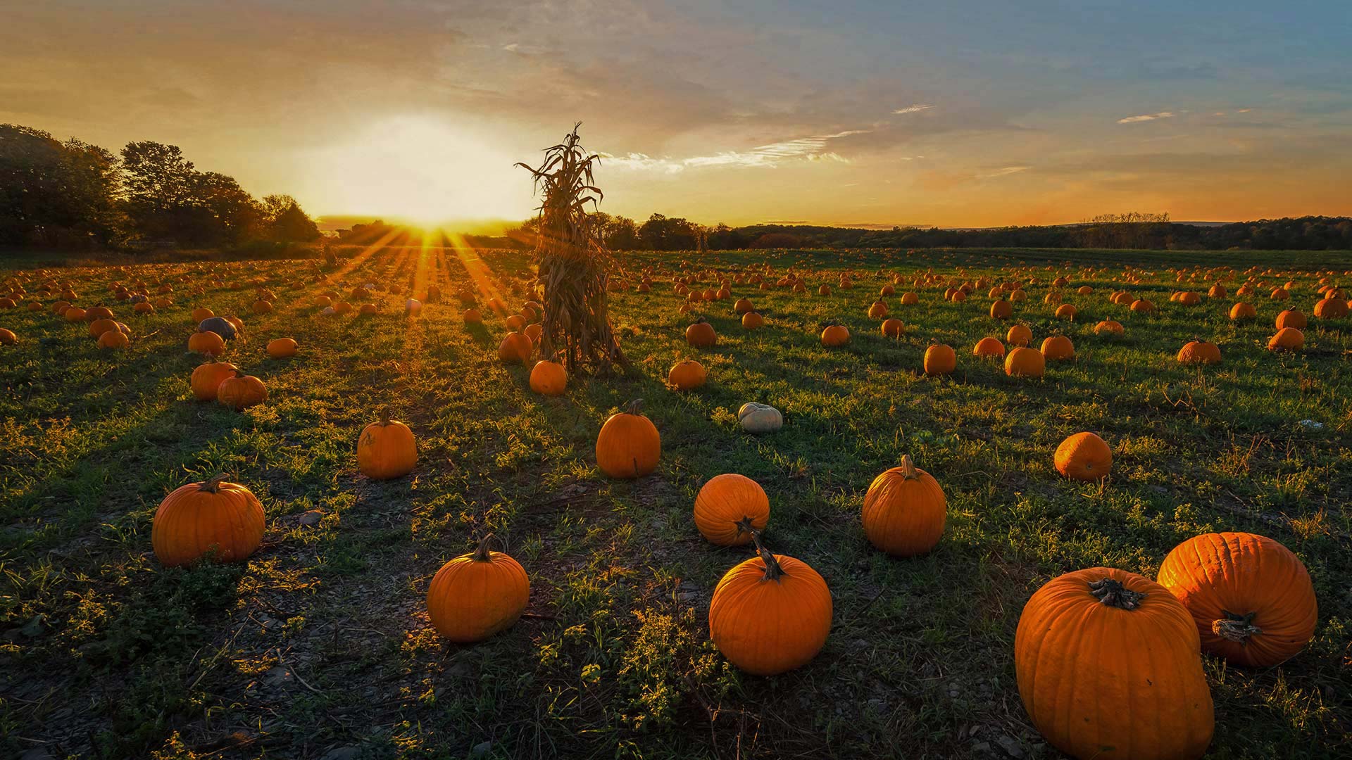
牛顿市的一片南瓜地,美国马萨诸塞州 A pumpkin patch in Newton, Massachusetts (© Frank Debonis/EyeEm/Alamy)
Pumpkin
It's not too late to pick up a pumpkin to add some Halloween flair to your doorstep. Although pumpkins are grown across the country, most of the 2 billion pounds produced in the US come from five states: California, Illinois, Indiana, Pennsylvania, and Texas. While California grows the most pumpkins headed for the jack-o'-lantern market, Illinois wins in poundage, though, most of its crop ends up as pie filling or other processed products—perhaps even your pumpkin spice latte?
And while we're talking orange orbs, what is a pumpkin exactly? You might think they're vegetables, but botanists say they're the fruit of pumpkin vines. They're considered fruit because pumpkins contain seeds and grow from the same part of the plant that produces flowers. Whether you opt to consume or carve, we invite you to enjoy this fruit of the spookiest season!
南瓜
现在还来得及拿起一个南瓜来给你的门阶增添万圣节的气息。尽管南瓜在全国各地都有种植,但美国生产的20亿磅南瓜中的大部分来自五个州:加利福尼亚州、伊利诺伊州、印第安纳州、宾夕法尼亚州和得克萨斯州。虽然加利福尼亚州种植的南瓜最多,销往南瓜灯市场,但伊利诺伊州的南瓜收成却以手续费取胜,尽管如此,它的大部分南瓜收成都是馅饼馅料或其他加工产品,甚至是你的南瓜香料拿铁?
当我们谈论橙色球体时,南瓜到底是什么?你可能认为它们是蔬菜,但植物学家说它们是南瓜藤的果实。南瓜之所以被认为是水果,是因为南瓜含有种子,并且是从植物的同一部位生长而成的。无论您选择消费还是雕刻,我们都邀请您享受这个最恐怖季节的水果!
星空下的仙人掌家族,美国萨瓜罗国家公园 Saguaro 'family' and Milky Way, Saguaro National Park, Arizona (© Christian Foto Az/Shutterstock)
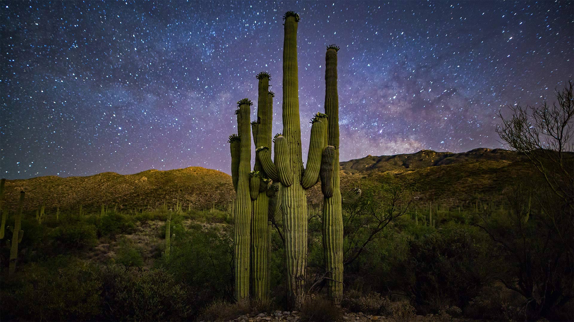
星空下的仙人掌家族,美国萨瓜罗国家公园 Saguaro 'family' and Milky Way, Saguaro National Park, Arizona (© Christian Foto Az/Shutterstock)
Happy birthday, Saguaro National Park
If you know what these distinctively shaped cactuses are called, you can name this patch of public land in the Sonoran Desert. Saguaro National Park was established on this day in 1994 to protect giant saguaros like these. The slow-growing, prickly behemoths have been known to reach almost 80 feet into the Arizona sky. Just don't be tempted to climb one—take it from us, a closer look at that celestial display isn't worth getting jabbed by 3-inch saguaro spines.
生日快乐,萨瓜罗国家公园
如果你知道这些形状独特的仙人掌叫什么,你可以把这片公共土地命名为索诺兰沙漠。萨瓜罗国家公园是在1994年的这一天建立的,旨在保护像这样的巨型萨瓜罗。这只生长缓慢、多刺的庞然大物已被发现能伸入亚利桑那州的天空近80英尺。只是不要被诱惑去攀爬,从我们这里拿走它,更仔细地看一看天空的显示是不值得被3英寸的萨瓜罗刺戳的。
加利福尼亚州的一艘集装箱船,美国 Container ship in San Pedro, California (© Cameron Venti/Getty Images)

加利福尼亚州的一艘集装箱船,美国 Container ship in San Pedro, California (© Cameron Venti/Getty Images)
Global commerce in motion
The COVID-19 pandemic has been rough sailing for everyone, and especially so for seafarers on shipping vessels. As if moving more than 80% of the world's goods wasn't a big mission already, the pandemic brought about urgent needs in every corner of the globe, while also forcing travel restrictions that made shipping more complicated. Hundreds of thousands of sailors and other shipping personnel have found themselves stuck on ships much longer than planned as virus precautions impede crew changes.
So this year's World Maritime Day—always observed on the last Thursday in September—is a good day to salute the workers who help keep global commerce in motion. World Maritime Day was established by the UN to improve shipping efficiency through international standards and cooperation—on safe crew-change procedures during a pandemic, for example. Maritime Day also aims to put seafarers and their sacrifices in the spotlight. Thanks, sailors!
全球商业活动
新冠病毒-19大流行对每个人来说都是一次艰难的航行,尤其是对船舶上的海员来说。似乎运输世界上80%以上的货物还不是一项重大任务,这场大流行在全球每个角落都带来了迫切的需求,同时也迫使旅行限制,使运输更加复杂。由于病毒预防措施阻碍了船员的更换,数十万水手和其他船务人员发现自己被困在船上的时间比计划的要长得多。
因此,今年的世界海事日总是在9月的最后一个星期四举行,这是一个向帮助保持全球商业运转的工人致敬的好日子。例如,世界海事日是由联合国设立的,目的是通过国际标准和在大流行期间安全船员更换程序方面的合作来提高航运效率。海事日还旨在让海员及其牺牲成为人们关注的焦点。谢谢,水手们!