标签 美国 下的文章
鲨鱼鳍湾,达文波特,加利福尼亚州,美国 Shark Fin Cove, Davenport, California (© Jeff Lewis/Tandem Stills + Motion)
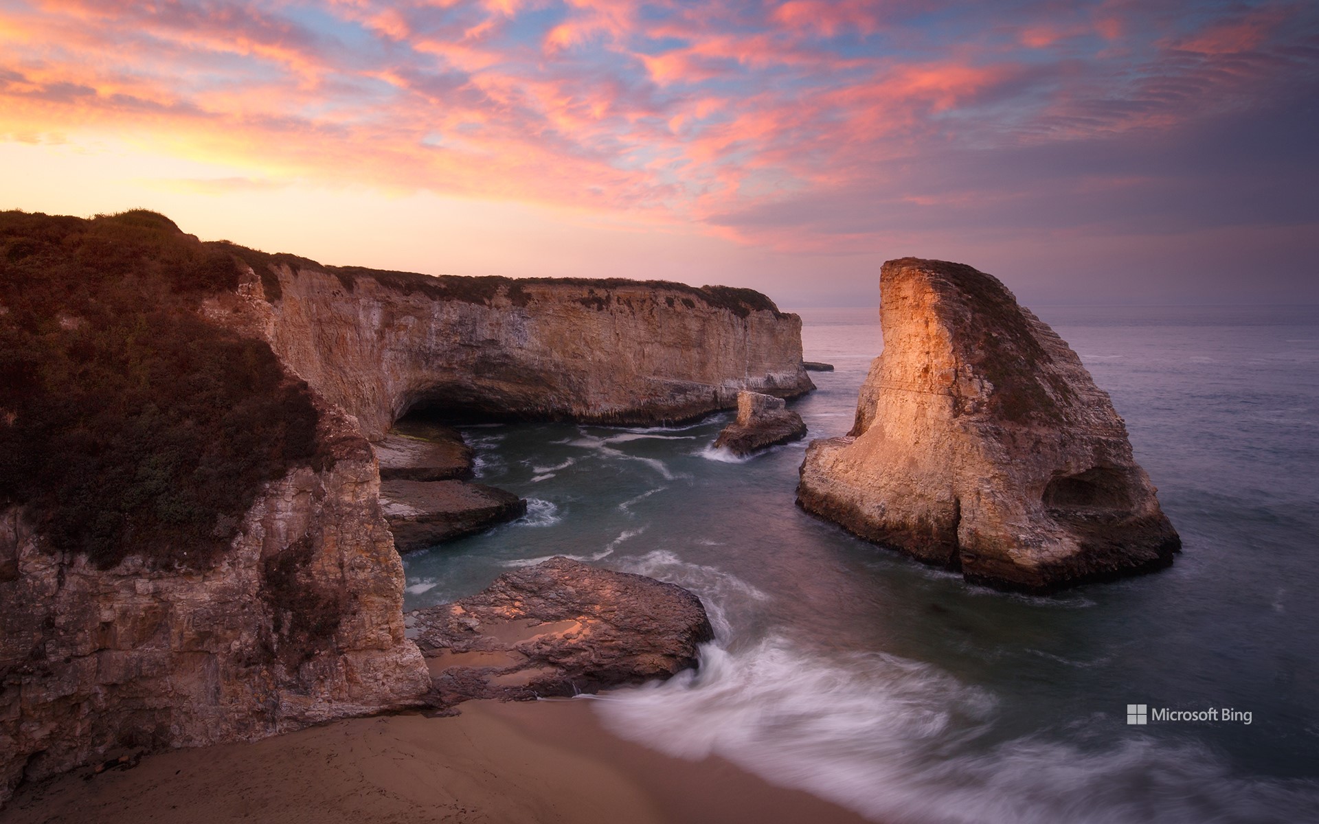
鲨鱼鳍湾,达文波特,加利福尼亚州,美国 Shark Fin Cove, Davenport, California (© Jeff Lewis/Tandem Stills + Motion)
自然“鳍”观 What a fin-tastic view!
鲨鱼鳍湾,加利福尼亚州,美国
鲨鱼鳍湾依偎在加州中部海岸小城达文波特附近海湾一隅。这个海湾中有一个形似鲨鱼鳍的海蚀柱,海湾也因此得名“鲨鱼鳍湾”。这个鲨鱼鳍状的海蚀柱曾是包围海滩的泥岩悬崖的一部分,在长年累月的海浪和大风的侵蚀作用下,最终形成了这个“鲨鱼鳍”。从一号公路上可以看到鲨鱼鳍湾,旅行者可以在此停留,一览无垠的太平洋。
Shark Fin Cove, California
Shark Fin Cove, also known as Shark Tooth Beach, is nestled in a cove in the tiny town of Davenport on California's Central Coast. The cove is a coastal gem known for its stunning sea stack—a vertical rock formation that resembles a shark's fin. The fin used to be connected to the mudstone cliff that surrounds the beach. Over time, the relentless crashing waves and strong winds slowly eroded the rock formation. Shark Fin Cove is visible from Highway 1, where travelers can stop and look at the expansive Pacific Ocean views.
基韦斯特的七英里大桥,佛罗里达州,美国 Seven Mile Bridge in the Florida Keys (© Evgeny Vasenev/Cavan Images)
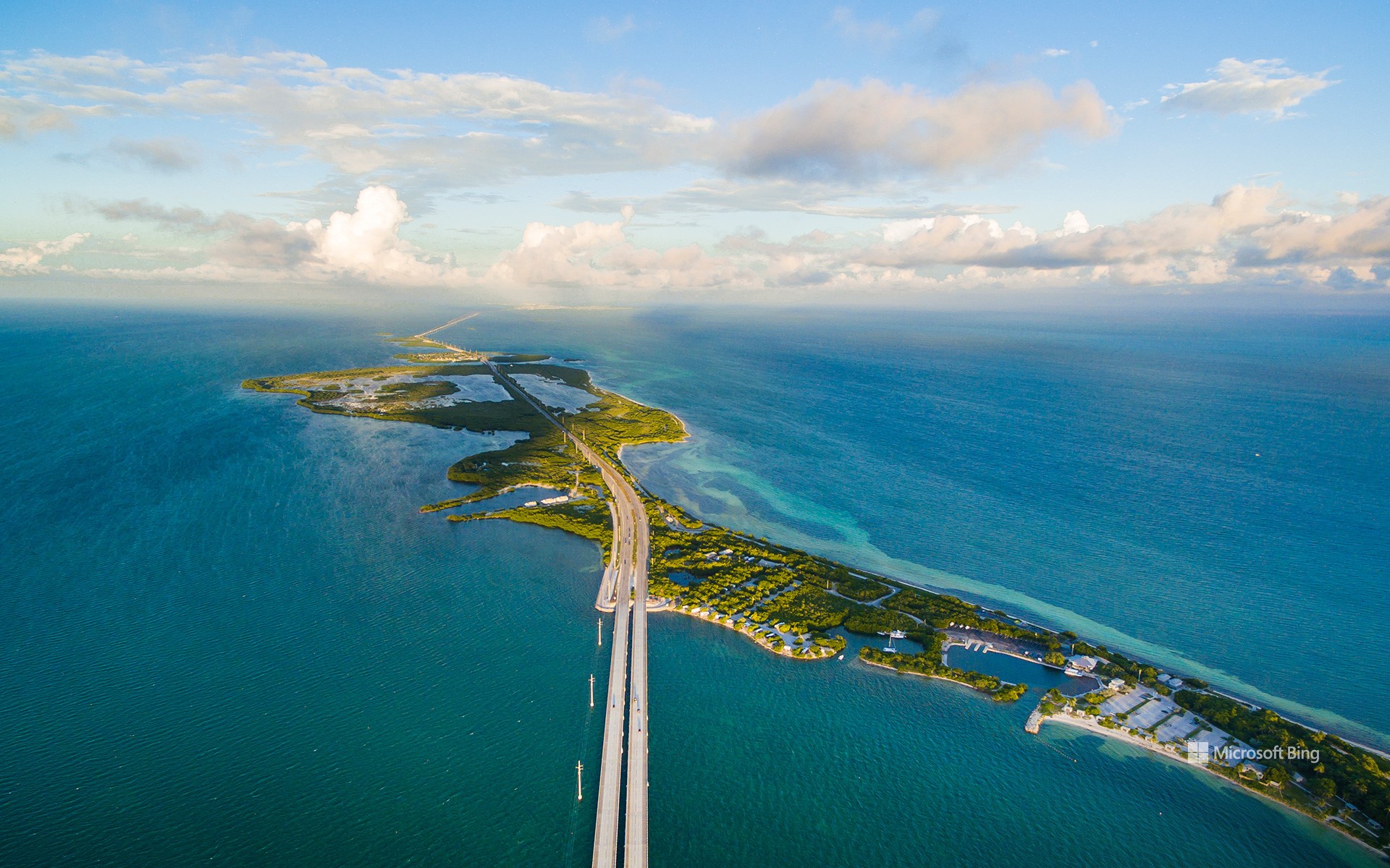
基韦斯特的七英里大桥,佛罗里达州,美国 Seven Mile Bridge in the Florida Keys (© Evgeny Vasenev/Cavan Images)
一把通向岛屿的钥匙 A key to island travel
七英里大桥,佛罗里达州,美国
很久很久以前,佛罗里达州住着一位富有的实业家,名叫亨利·弗拉格勒。他启动了一项艰巨的工程:修建一条连接佛罗里达大陆和基韦斯特的跨海铁路。最终,七英里桥于1912年正式落成,被称为世界第八大奇迹。然而,奇迹并不长久,1935年,这座大桥遭遇飓风从而停止了运营。后来,这座桥被卖给了美国政府,经历重建后摇身一变,成了一条汽车高速公路,于1938年重新开放。
如今,你若到访这座久负盛名的七英里桥,你会发现两座桥:一座是老七英里桥,仅对行人和骑自行车的人开放,另一座是于1982年建成的新七英里桥,用于车辆通行。好莱坞大片《杀人执照》和《真实的谎言》中都曾出现过这座桥的身影。
Overseas Highway, Florida Keys
Once upon a time, there lived a wealthy industrialist, Henry Flagler, who embarked on the herculean task of creating an overseas railway connecting mainland Florida to Key West. When it opened in 1912, it was dubbed the Eighth Wonder of the World. However, the triumph was short-lived. It was hit by a hurricane on Labor Day, 1935 and the railroad discontinued operations. The railway was sold to the US government and rebuilt as an automobile highway, opening in 1938.
These days, the Overseas Highway still stretches about 113 miles through the Florida Keys over 42 bridges, which jump from island to island over the Atlantic Ocean, Florida Bay, and the Gulf of Mexico. Many of the original bridges were replaced in 1982, including the longest, the Seven Mile Bridge pictured in the distance in our homepage image. Drivers crossing the Overseas Highway can still see remnants of some of the old bridges running alongside their replacements, including the Old Seven Mile Bridge, a section of which was renovated for cyclists and pedestrians. An engineering marvel, the ‘highway that goes to sea' has also featured in blockbusters like 'License to Kill' and 'True Lies.'
英仙座流星雨,白杨木峡谷州立公园,俄勒冈州,美国 Perseid meteor shower, Cottonwood Canyon State Park, Oregon (© Joshua Meador/Tandem Stills + Motion)
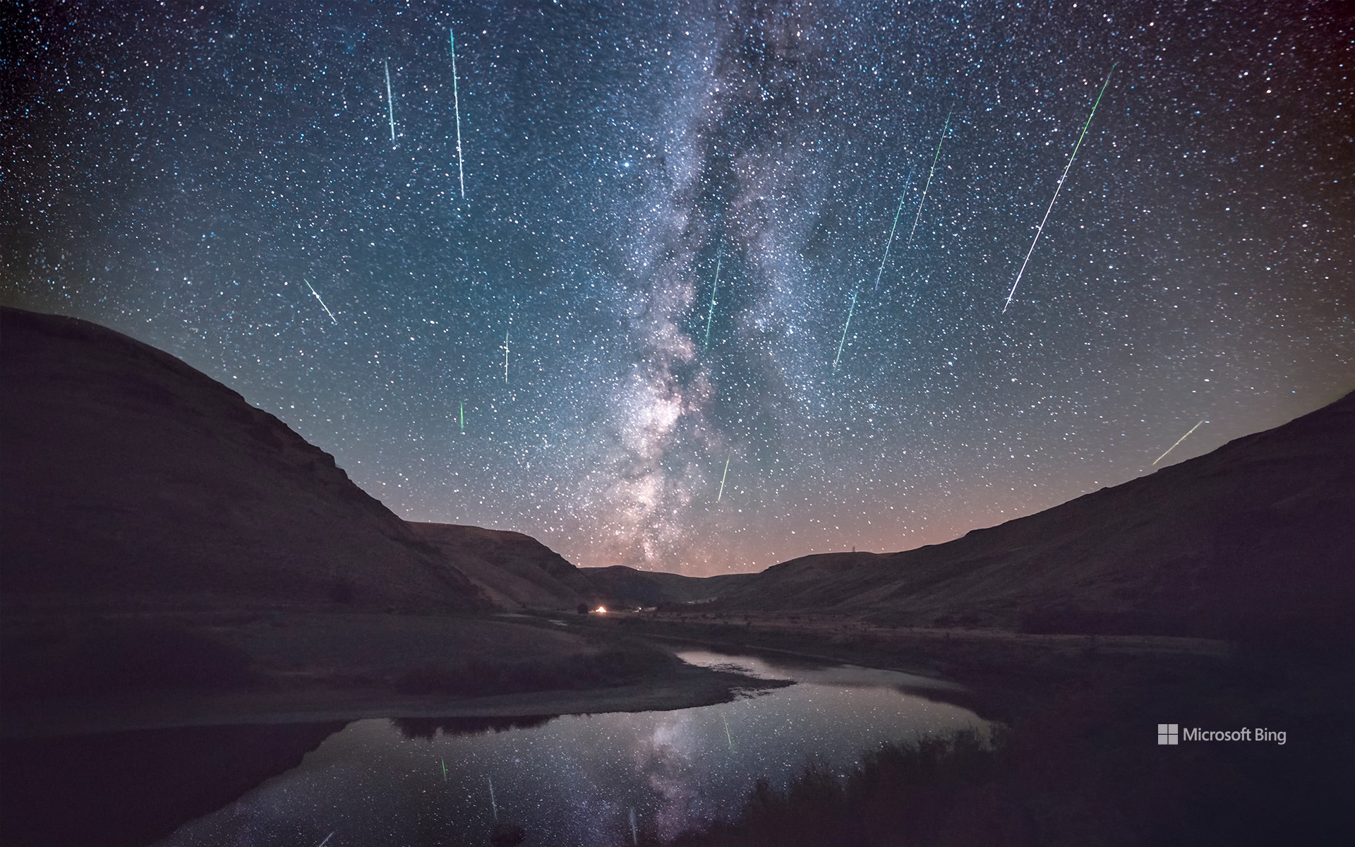
英仙座流星雨,白杨木峡谷州立公园,俄勒冈州,美国 Perseid meteor shower, Cottonwood Canyon State Park, Oregon (© Joshua Meador/Tandem Stills + Motion)
抬头看,它来了 Look up, incoming…
英仙座流星雨
当我们的祖先看到安静的夜空突然下起流星雨,他们会是什么感受?是惊惧还是惊叹?好在现在的我们已经知道,这是一场年度“灯光秀”,被称为英仙座流星雨,活跃期一般在每年的7月中旬至8月下旬。英仙座流星雨是由地球穿过斯威夫特-塔特尔彗星留下的碎片造成的,当这些碎片撞击地球大气层,就会产生炽热的流星雨。今天正是英仙座流星雨的高峰期,月亮预计只有10%的亮度,今晚可千万别错过“赏雨”哦!
Perseid meteor shower over Oregon
What must our ancestors have thought when they saw meteors light up the night sky? Was it terrifying or an event of wonder? Thankfully, we now know that this celestial cascade is a harmless annual event. The Perseid meteor shower thrills stargazers from mid-July to late August and is due to peak today. The Perseids are caused by Earth passing through debris left behind by the Comet Swift-Tuttle. When the cosmic debris hits our atmosphere, it disintegrates in a colorful, fiery light display. It's a good night to catch the Perseids if you can—the moon is projected to only be 10% illuminated, so the meteors should really stand out against the dark sky.
博迪岛灯塔,马头城,北卡罗来纳州,美国 Bodie Island Lighthouse, Nags Head, North Carolina (© Michael Ver Sprill/Getty Images)
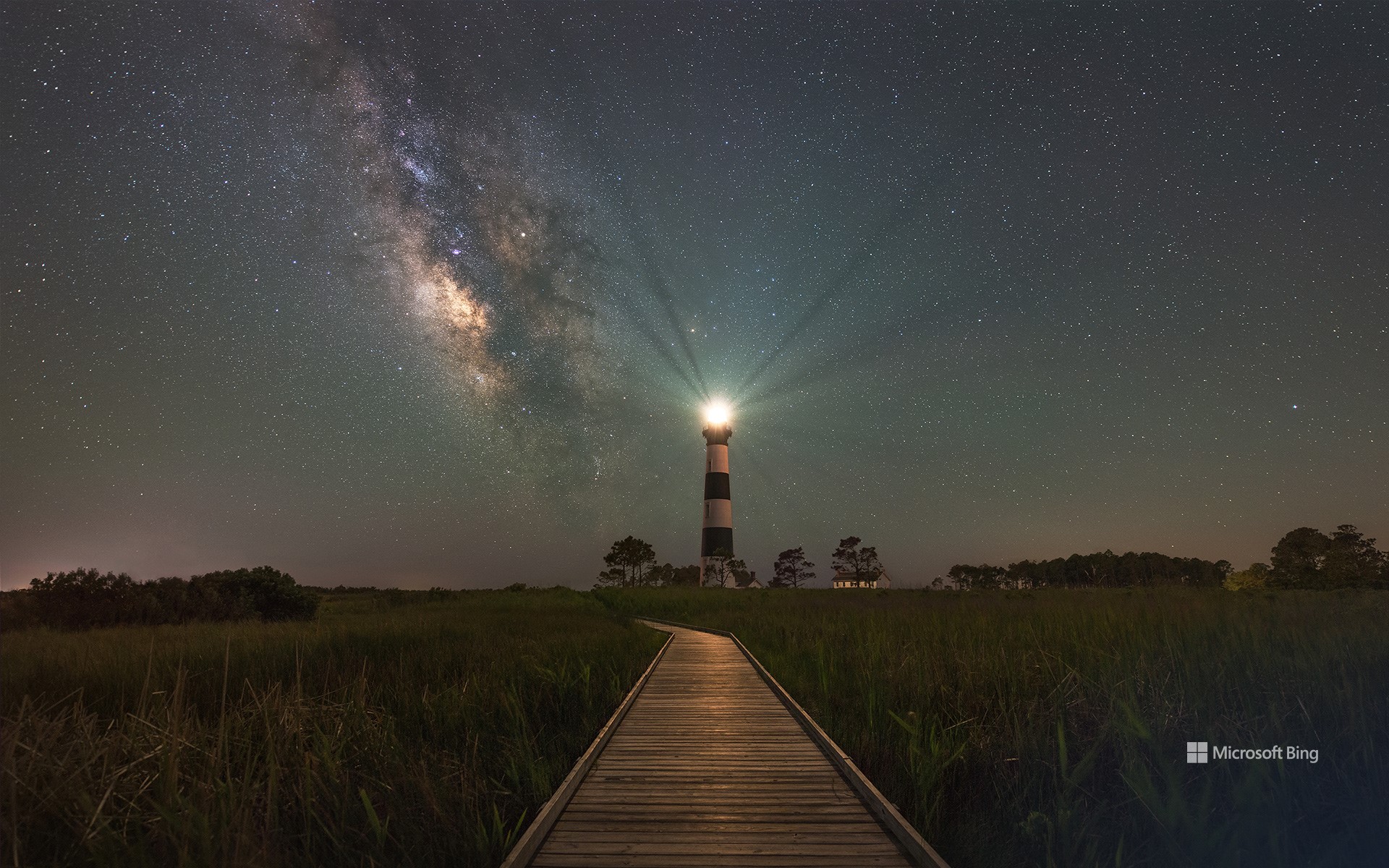
博迪岛灯塔,马头城,北卡罗来纳州,美国 Bodie Island Lighthouse, Nags Head, North Carolina (© Michael Ver Sprill/Getty Images)
地上一点,天上万千 One on land, a million in space
博迪岛灯塔,北卡罗来纳州,美国
作为信标、警告、亦是希望和回家的象征,灯塔已经存在了几千年。几个世纪以来,科技一直在进步,如今的灯塔技术远非几百年前的灯塔可比,人们在20英里之外就能看见现代灯塔的灯光。今天照片里展示的是始建于1872年的博迪岛灯塔,它俯瞰一片被称为大西洋坟场的海域。自建成之日起它就在和头顶群星争辉,指引水手回到安全的港湾。
National Lighthouse Day
Happy National Lighthouse Day! A beacon, a warning, and a symbol of hope and home, lighthouses have existed for thousands of years. The earliest known was the Pharos of Alexandria, which stood an estimated 330 feet tall. Built by the ancient Egyptians in the 3rd century BCE, an open fire was lit at its highest part to guide ships into port. Illumination technology advanced over the centuries, culminating in today's electric versions beaming light that can be seen from over 20 miles away. North Carolina's Bodie Island Lighthouse, pictured here, was built in 1872 and overlooks a section of ocean once known as the Graveyard of the Atlantic. Since then, it's been doing its best to outshine the stars above, as it guides sailors home to safe harbor.
圆顶礁国家公园的砂岩山丘,犹他州,美国 Sandstone butte in Capitol Reef National Park, Utah (© Amazing Aerial Premium/Shutterstock)
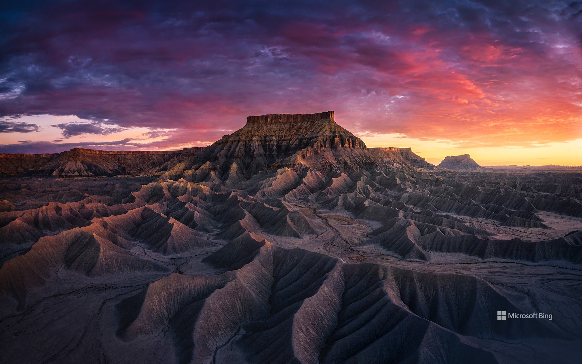
圆顶礁国家公园的砂岩山丘,犹他州,美国 Sandstone butte in Capitol Reef National Park, Utah (© Amazing Aerial Premium/Shutterstock)
大自然色调的调色板 A painter's palette of nature's hues
圆顶礁国家公园,犹他州,美国
在圆顶礁国家公园,到处都是犹他州红岩地区崎岖壮丽的景色。这座隐藏在美国西南部的宝藏公园占地超过20万英亩,就像是一幅由高耸的悬崖、曲折的峡谷、色彩斑斓的砂岩山丘和广阔的沙漠景观组成的画卷。公园里最著名的,就是诞生于5000万到7000万年前的、绵延近100英里的褶皱地形。圆顶礁国家公园也是各种动植物的家园,其中还包括了行踪不定的沙漠大角羊和230多种鸟类。
Capitol Reef National Park, Utah
Behold the rugged grandeur of Utah's red rock country. This hidden gem of the American Southwest is Capitol Reef National Park, a tapestry of towering cliffs, twisting canyons, colorful sandstone buttes, and sweeping desert landscapes. Less popular than Zion and Bryce Canyon, the park offers a pleasantly uncrowded experience for visitors keen to enjoy this spectacular landscape. It is also home to a wide variety of plants and animals, including the elusive desert bighorn sheep and more than 230 bird species. But its crown jewel is the nearly 100-mile long Waterpocket Fold, a 7,000-foot-high step in the rock layers, officially known as a monocline. This massive wrinkle on the surface of the planet was formed around 50 to 70 million years ago.
从德纳里山看福克拉山,德纳里国家公园,美国阿拉斯加州 Climber on Denali, Denali National Park, Alaska (© Andrew Peacock/Tandem Stills + Motion)
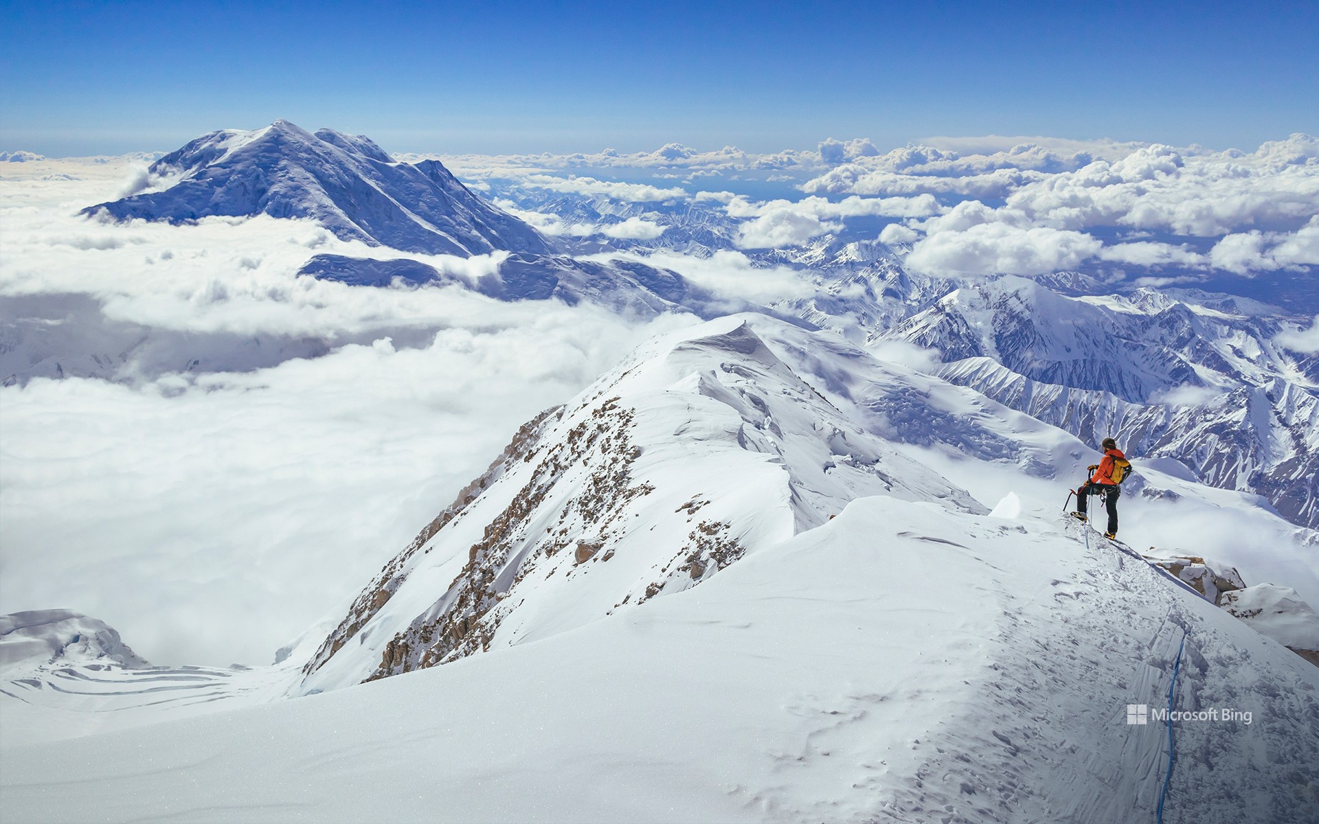
从德纳里山看福克拉山,德纳里国家公园,美国阿拉斯加州 Climber on Denali, Denali National Park, Alaska (© Andrew Peacock/Tandem Stills + Motion)
德纳里山的力量无可否认 There's no denying the power of Denali
美国登山日
今天是美国登山日。为了攀登高峰和征服困难地形,登山者们需要专业的训练和丰富的经验,登山途中更是一段艰辛的旅程。但是,登上山顶俯瞰山下风景的那一刻,所有的艰辛都是值得的。今天图片中展示的是北美最高峰德纳里山,海拔超2万英尺,位于阿拉斯加的德纳里国家公园和保护区。“德纳里”一词源于阿萨巴斯卡语,是“至高者”的意思。
National Mountain Climbing Day
Today is National Mountain Climbing Day, dedicated to celebrating the sport while highlighting its many risks and rewards. In a bid to scale the tallest peaks and conquer difficult terrain around the world, mountain climbers embark on physically strenuous journeys that demand exceptional training and experience. But the panoramic views and sense of achievement after reaching the summit makes the effort worthwhile. Our image today is that of Denali, North America's highest peak at 20,310 feet, in south-central Alaska. The name 'Denali' means 'the high one' in the native Athabascan language. Four climbers, Walter Harper, Harry Karstens, Robert Tatum, and Hudson Stuck, were the first to set foot on the top of the mountain in 1913.
霍金山州立公园的岩石屋,俄亥俄州,美国 Rock House, Hocking Hills State Park, Ohio (© Kenneth Keifer/Getty Images)
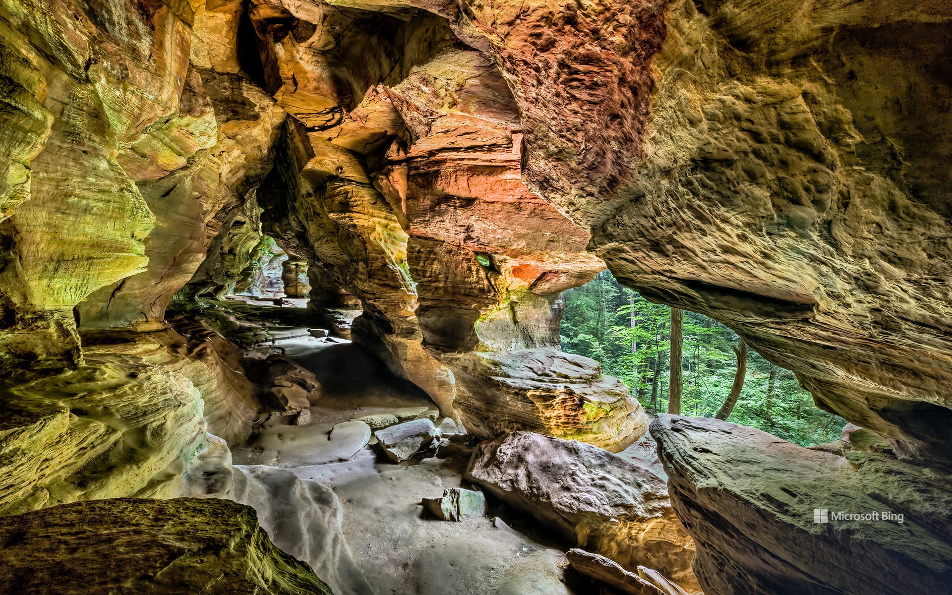
霍金山州立公园的岩石屋,俄亥俄州,美国 Rock House, Hocking Hills State Park, Ohio (© Kenneth Keifer/Getty Images)
有人在家吗? Is anybody home?
霍金山州立公园的岩石屋,俄亥俄州,美国
美丽宽敞的岩石屋是霍金山州立公园唯一的真正洞穴。该洞穴之所以被命名为岩石屋,是因为它曾在不同时期被不同的居住者用作避难所。岩石屋坐落在悬崖半山腰处,便于防御。早在欧洲移民到来之前,这里常被美洲原住民用于避难和举行仪式。
岩石屋的墙壁上有七个侵蚀而成的开口。这些“窗户”创造了有趣的视觉效果,阳光透过“窗户”,在洞穴内投射出美丽的图案。考古证据表明,洞穴居民曾用岩壁上的凹槽当烤炉,用地面水槽收集水。
Rock House in Hocking Hills State Park, Ohio
Ancient and beautiful, Rock House is the only true cave in Ohio's Hocking Hills State Park. This corridor, halfway up a 150-foot cliff, was carved by erosion and has offered shelter to various dwellers over different periods. Long before European settlers arrived, the area's Native American people are believed to have used Rock House as a refuge. Small recesses in the rock walls are thought to have been used as baking ovens, while troughs gouged in the cave's floor helped them to collect water. The walls of Rock House have seven window-like openings, allowing sunlight to filter through, casting beautiful patterns inside the cave and offering cliffside views over the trees for generations of Rock House dwellers.
帕卢斯的农田,华盛顿州,美国 Farmland in the Palouse, Washington (© EJ-J/Getty Images)
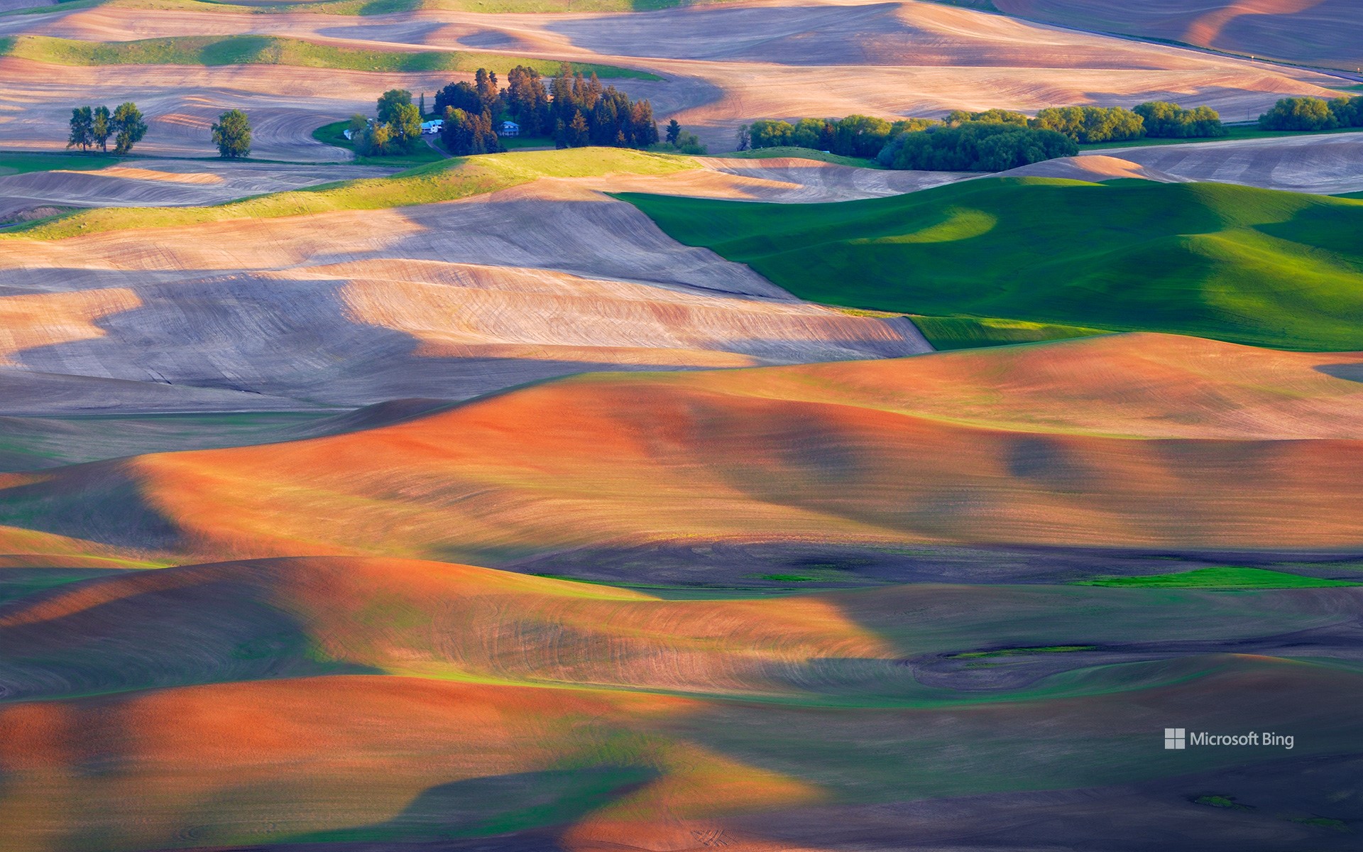
帕卢斯的农田,华盛顿州,美国 Farmland in the Palouse, Washington (© EJ-J/Getty Images)
宛若仙境的帕卢斯田园 Perfect, pastoral Palouse
帕卢斯的农田,华盛顿,美国
美国的帕卢斯地区以风景如画的景观和独特的地质特征而闻名。延绵起伏的丘陵田原一望无际,错落有致、金绿相间的麦浪美不胜收,相比意大利的托斯卡纳和法国乡村也毫不逊色。帕卢斯是一个农业区,当地土壤肥沃和气候适宜,盛产小麦、大麦、豌豆和小扁豆等。
Palouse farmland, Washington state
The Palouse region in the Pacific Northwest is known for its picturesque landscapes, agricultural heritage, and unique geological features. Those stunning hills in our homepage image were formed over tens of thousands of years, from dust and silt blown by the wind, known as loess. The Palouse's fertile soil and climate make it ideal for farming and it is known for its wheat, barley, lentils, and other crops. With its beautiful rolling hills covered in patchworks of green and golden fields, it is often compared to Italy's Tuscany region or the French countryside.
在一棵秃柏树上吊床露营,佛罗里达州,美国 Hammock camping in a bald cypress tree, Florida (© Mac Stone/Tandem Stills + Motion)
在一棵秃柏树上吊床露营,佛罗里达州,美国 Hammock camping in a bald cypress tree, Florida (© Mac Stone/Tandem Stills + Motion)
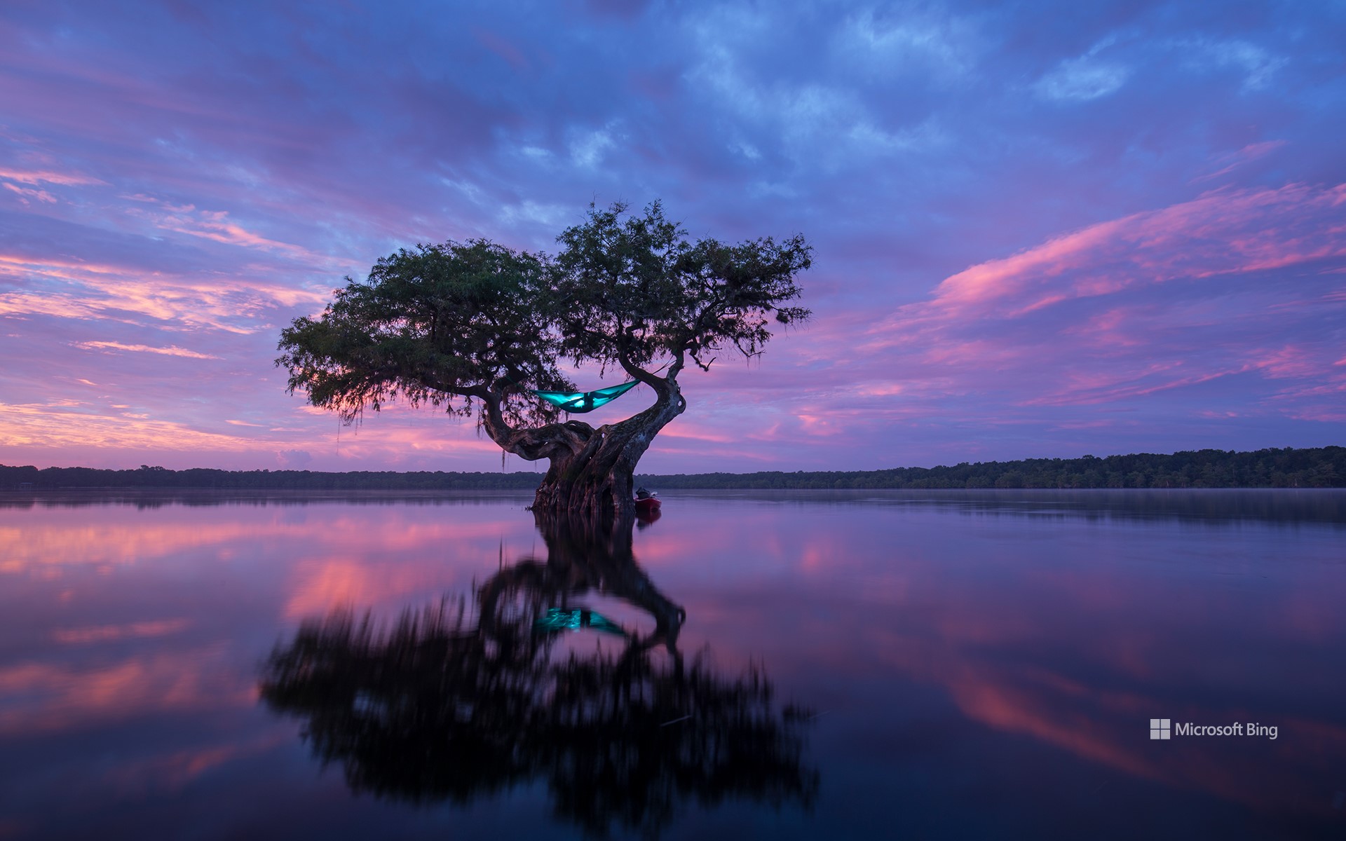
想出去玩吗? Want to hang out?
在一棵秃柏树上吊床露营,佛罗里达州
传统的吊床是由中美洲人发明的,最初是用来在睡觉时保护自己免受危险的昆虫和动物的袭击。如今,吊床是一个用来增添乐趣的工具。由布料、网或绳子等各种各样的材料制作而成的吊床,是旅行者最好的伙伴。在佛罗里达州,秃柏树就是一个挂吊床的绝佳去处。
National Hammock Day
It’s National Hammock Day! A day to slowly unwind while rocking gently from side to side. These days, hammocks are associated with summer relaxation, but they were originally developed by Central Americans to protect them from dangerous insects and animals. Today the hammock is a traveler's best buddy, made from a variety of materials like fabric, netting, or rope. But where best to hang it? Florida boasts some beautiful hammock hang-out spots, like the bald cypress tree pictured on our homepage. Have hammock, will travel and relax. It's just that simple.
熊洞溪,卡茨基尔山脉,纽约,美国 Bear Hole Brook, Catskill Mountains, New York (© GummyBone/Getty Images)
熊洞溪,卡茨基尔山脉,纽约,美国 Bear Hole Brook, Catskill Mountains, New York (© GummyBone/Getty Images)
溪水潺潺 Babbling on and on
熊洞溪,卡茨基尔山脉,纽约
卡茨基尔山脉坐落在纽约州北部,面积超过4000平方英里,以令人惊叹的美景闻名。连绵不绝的山峰和古老的森林勾勒出迷人的背景,山谷孕育着蜿蜒流动的小溪,就像我们今天看到的熊洞溪。该地区拥有众多迂回曲折的徒步旅行路线,穿越茂密的林地,通向令人敬畏的壮丽景色。卡茨基尔在文化史上也占有重要地位,多年来一直吸引着世界各地的艺术家和梦想家。从标志性的度假胜地到迷人的小村庄,这里独特的魅力一直吸引着源源不断的游客到访。
Bear Hole Brook, Catskill Mountains, New York
Stretched over 4,000 square miles in upstate New York, the Catskill Mountains captivate visitors with their breathtaking beauty. Towering peaks cloaked in forests surround valleys filled with meandering streams like Bear Hole Brook, seen in today's image. The region boasts hiking trails that wind through enchanting woodlands, past waterfalls and lakes while motorists can enjoy scenic drives and spot the region's covered bridges, dating from the 1800s. The Catskills also hold a place in cultural history, attracting artists and dreamers and as the fictional setting for the movie 'Dirty Dancing'—which was actually filmed in Pembroke, Virginia. With other attractions including ski resorts and picturesque small towns and hamlets, visitors continue to flock to the Catskills, a huge wilderness within driving distance of more than 20 million Americans.