阿尔贝罗贝洛的特鲁洛建筑,普利亚大区,意大利 Trullo buildings in Alberobello, Apulia, Italy (© Feng Wei Photography/Getty Images)
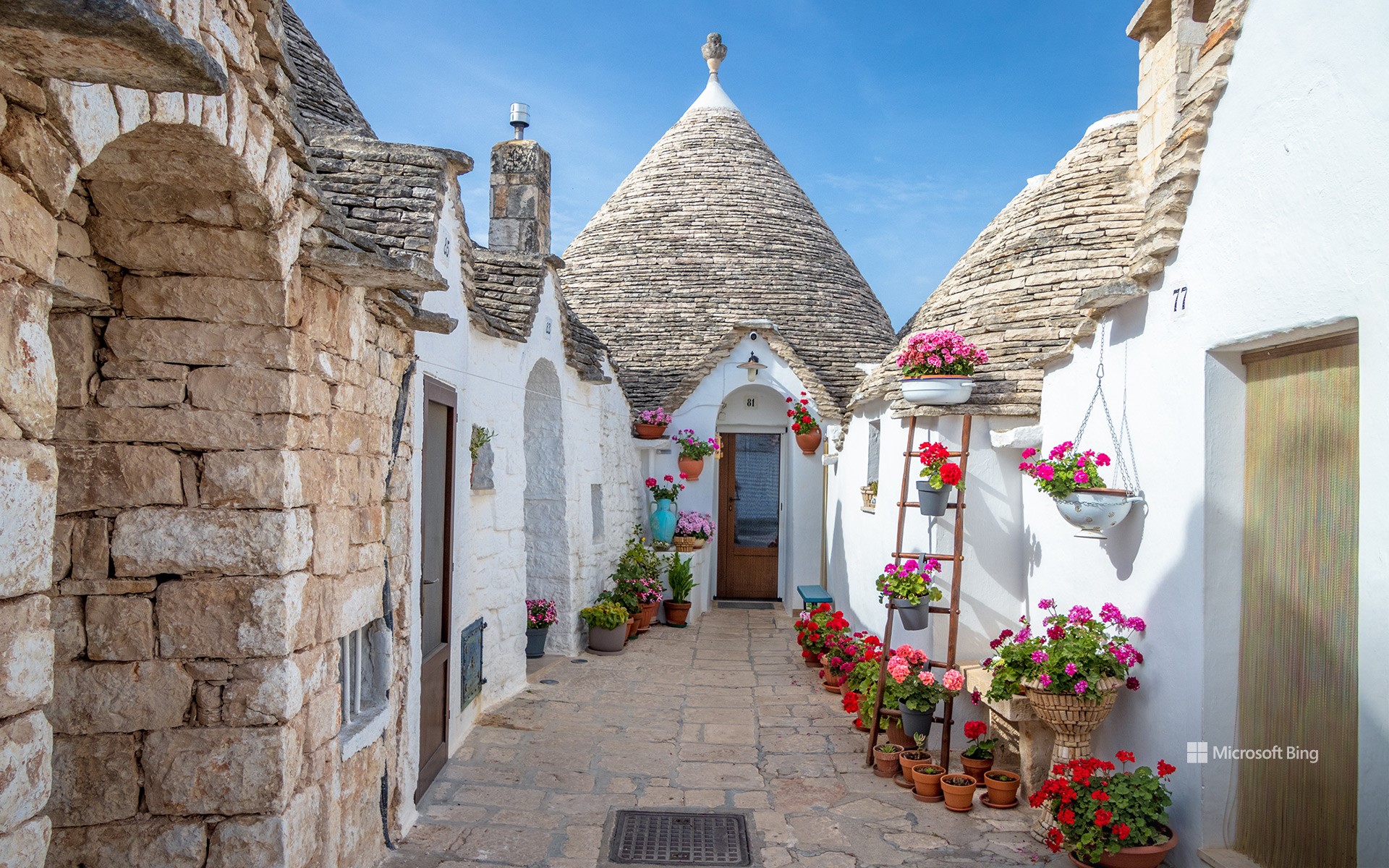
阿尔贝罗贝洛的特鲁洛建筑,普利亚大区,意大利 Trullo buildings in Alberobello, Apulia, Italy (© Feng Wei Photography/Getty Images)
一座非凡的特鲁洛小镇 A 'trulli' remarkable town
阿尔贝罗贝洛的特鲁洛建筑,意大利
如果童话故事里有建筑师,他们或许能创造出像意大利阿尔贝罗贝洛那样的景象。但这座小镇的标志性建筑——特鲁利(trulli,单数为trullo),并非靠魔杖,而是石灰岩、无砂浆砌筑,以及——根据某些理论——一些逃税手段——才得以建成。这些粉刷过的石屋顶部是干砌的石灰岩屋顶,形状像倒置的冰淇淋蛋筒。这是一种古老的建筑技术,在阿尔贝罗贝洛,更是巧妙之举。据说早在14世纪,当地人就试图通过建造房屋来逃避房产税,因为国王的税务官来袭时,这些房屋很容易被拆除。
阿尔贝罗贝洛的特鲁利并非孤例。像蒙蒂区(Rione Monti)和小阿亚区(Aia Piccola)这样的整个街区都挤满了这些奇特的建筑。有些至今仍有人居住,有些则被改造成咖啡馆、纪念品商店和小型博物馆。你甚至还能找到一座特鲁利风格的教堂。1996年,联合国教科文组织将阿尔贝罗贝洛的特鲁利列为世界遗产。一个漏洞成为地标建筑的情况并非每天都有。
Trullo buildings in Alberobello, Apulia, Italy
If fairy tales had architects, they might've come up with something like Alberobello in Italy. But instead of magic wands, it was limestone, mortar-free masonry, and—according to some theories—a bit of tax evasion that built this town's signature homes: the trulli. These are whitewashed stone houses topped with dry-stacked limestone roofs shaped like upside-down ice cream cones. It's an ancient building technique, and in this case, a clever one. Back in the 14th century, locals were reportedly trying to avoid property taxes by constructing homes that could be quickly dismantled when the king's tax collector came around.
Alberobello's trulli aren't hidden one-offs. Entire districts—like Rione Monti and Aia Piccola—are packed with these quirky structures. Some are still lived in, while others have been transformed into cafés, souvenir shops, and pint-sized museums. You'll even find a church built in trullo style. In 1996, UNESCO gave the trulli of Alberobello the heritage stamp of approval. It's not every day that a loophole becomes a landmark.
方解石温泉区和黄石河,黄石国家公园,怀俄明州,美国 Calcite Springs Overlook and Yellowstone River, Yellowstone National Park, Wyoming (© Rebecca L. Latson/Getty Images)
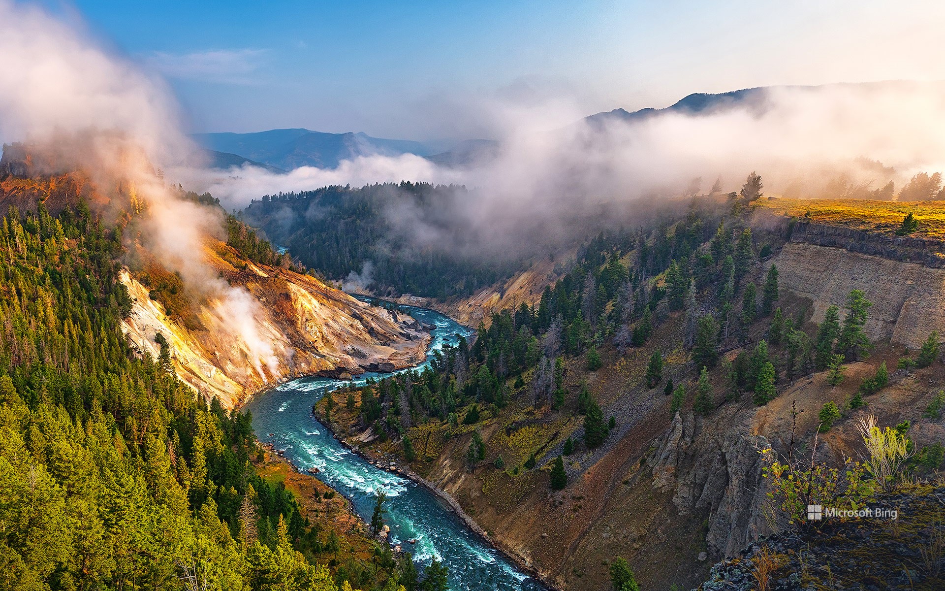
方解石温泉区和黄石河,黄石国家公园,怀俄明州,美国 Calcite Springs Overlook and Yellowstone River, Yellowstone National Park, Wyoming (© Rebecca L. Latson/Getty Images)
从火山之源到河流之路 From volcanic roots to river routes
方解石温泉区和黄石河,美国
黄石河是美国本土48州最后一条未建坝的主要河流,它从黄石公园东南方向发源,全长671英里(1080公里),汇入密苏里河,最终汇入大西洋。这座地热与峡谷交汇的观景台,让您近距离欣赏黄石河蜿蜒流经熔岩锻造的峡谷的壮丽景色。沿着玄武岩峭壁,可以看到富含矿物质的地下水仍在冒着热气,形成了白色的矿藏,方解石泉也因此得名。您或许还能看到白头鹰在头顶滑翔,或是野牛在附近悠闲地休息。黄石公园不仅仅是一个公园,它更是一座拥有游客中心的超级火山。
Yellowstone for the National Park Service's birthday
Today, the National Park Service celebrates another trip around the sun—and nearly 85 million acres of American beauty under its care. From geysers that spout like soda cans to ancient cliff dwellings tucked into canyon walls, the NPS has spent over a century preserving, protecting, and inviting people to take a hike—literally. In 1916, President Woodrow Wilson signed the Organic Act into law, officially creating the NPS to 'conserve the scenery and the natural and historic objects.' Since then, the NPS has grown to oversee more than 400 sites, including national parks, battlefields, monuments, and seashores.
What better spot to toast the occasion than the Calcite Springs Overlook in Yellowstone National Park, Wyoming? This thermal-meets-canyon overlook offers front-row views of the Yellowstone River carving its way through a lava-forged canyon. Along the basalt cliffs, white mineral deposits that gave Calcite Springs its name are visible, formed by mineral-rich waters still steaming from underground. You might spot a bald eagle gliding overhead or bison lounging nearby. Yellowstone is more than just a park—it's a supervolcano with a visitor center.
秋季九寨沟国家公园里的诺日朗瀑布, 四川省, 中国 Nuorilang Waterfall in Jiuzhaigou National Park in autumn, Sichuan province, China (© tawatchaiprakobkit/Getty images)
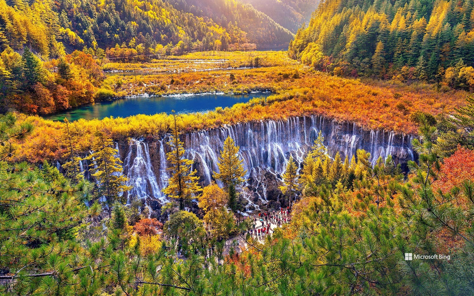
秋季九寨沟国家公园里的诺日朗瀑布, 四川省, 中国 Nuorilang Waterfall in Jiuzhaigou National Park in autumn, Sichuan province, China (© tawatchaiprakobkit/Getty images)
彩林叠翠间的瀑布 Waterfalls among colorful forests
诺日朗瀑布, 四川, 中国
立秋是秋季的第二个节气。这意味着夏季的炎热将从此消失。不过,天气依然闷热,不像秋天。人们称这种天气为 “秋老虎”,通常从8月22日左右开始,到8月24日左右结束。
诺日朗瀑布距四川省会成都400公里,位于九寨沟景区中部,地理位置优越。距离典型藏式建筑的游客服务中心仅 300米(984英尺)。诺日朗在藏语中的意思是男性之神,强壮而威武。它海拔2365米(7759英尺),是中国最大的洞穴瀑布之一。
帕卢斯连绵起伏的丘陵,华盛顿州,美国 Rolling hills of the Palouse, Washington (© svetlana57/Getty Images)
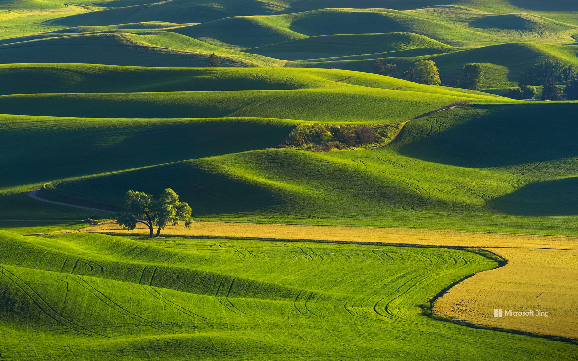
帕卢斯连绵起伏的丘陵,华盛顿州,美国 Rolling hills of the Palouse, Washington (© svetlana57/Getty Images)
大自然的绿色地毯 Nature's green quilt
帕卢斯连绵起伏的丘陵,华盛顿州
一波又一波的柔软丘陵绵延于帕卢斯地区。这片宁静的区域位于华盛顿州东南部,向爱达荷州和俄勒冈州的边界延伸。覆盖着小麦的坡地随着季节更迭而变换色彩。春季,丘陵呈现出郁郁葱葱的绿色,年轻的小麦和大麦开始生长;夏季则转变为干燥的金黄色,作物即将收割。
常被誉为华盛顿州最宁静的自然奇观之一,帕卢斯地区标志性的起伏山丘源于一段古老而引人入胜的地质故事。这些类似沙丘的山丘并非由河流或地壳运动塑造,而是由来自干旱西南部的风吹尘土和细粒淤泥(即“黄土”)在数千年中逐渐堆积而成。在冰河时代,来自加拿大的冰川将岩石磨成细小的“冰川粉”,这些粉尘流入史前时期的冰川密苏拉湖。当冰坝决堤时,洪水席卷了华盛顿州东部,留下层层淤泥。随后,主导风将这些尘埃带到该地区,沉积成我们今天所见的丘陵。
Rolling hills of the Palouse, Washington
Wave after wave of velvety hills stretch across the Palouse. This tranquil region lies in southeastern Washington, extending to the borders of Idaho and Oregon. The wheat-covered slopes shift in color with every passing season. In spring, the hills turn lush shades of green as young wheat and barley begin to grow, while summer transforms them into dry, golden browns as the crops near harvest.
Often hailed as one of Washington State's most serene natural wonders, the Palouse owes its signature rolling hills to an ancient and fascinating geological story. These dune-like hills were shaped over thousands of years—not by rivers or tectonic shifts, but by windblown dust and fine silt, known as 'loess,' carried from the arid Southwest. During the Ice Ages, glaciers from Canada ground rock into fine 'glacial flour,' which flowed into the prehistoric Glacial Lake Missoula. When ice dams broke, floods swept across eastern Washington, leaving behind layers of silt. Prevailing winds later carried that dust to this region, settling it into the hills we see today.
博尼法乔城堡,科西嘉岛南部,法国 The citadel in Bonifacio, Southern Corsica, France (© Marc Dozier/Getty Images)
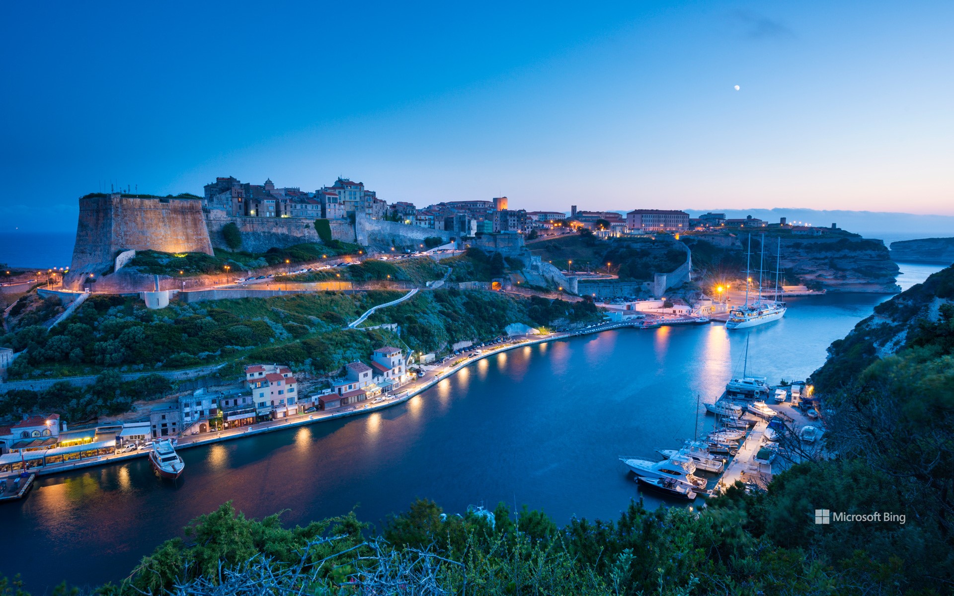
博尼法乔城堡,科西嘉岛南部,法国 The citadel in Bonifacio, Southern Corsica, France (© Marc Dozier/Getty Images)
永恒的建筑 Built to last
博尼法乔城堡,科西嘉岛南部,法国
位于科西嘉岛南端边缘的博尼法乔,隔着狭窄的海峡遥望撒丁岛,石灰岩峭壁高耸于海浪之上。最初,这里并非风景如画的旅游胜地,而是作为沿海防御工事而建立,在数百年间守护着地中海最繁忙的航道之一。公元828年,托斯卡纳的博尼法斯二世创建了博尼法乔公社,这里逐渐成为商人、士兵与水手聚集的地方,各方人群共同推动了城镇的发展。博尼法乔分为两部分:老城区(又称上城)位于高耸的悬崖之上,坐落在最初的城堡围墙内;而下方的滨海区则沿着狭长的海湾分布,拥有港口、海边住宅和日益发展的山谷社区。
在博尼法乔,城堡是不可错过的地标。这座城堡最初建于9世纪,后来不断扩建。如今,游客可以漫步在宁静的街道、古老的军事建筑与鹅卵石铺就的小巷中。周边还有“海洋公墓”、阿拉贡国王台阶,以及如今作为小型博物馆开放的旗帜堡垒等景点,等待人们前来探索。
The citadel in Bonifacio, Southern Corsica, France
Set at Corsica's southern edge, Bonifacio looks out across a narrow strait to Sardinia, its limestone cliffs towering above the waves. Bonifacio didn't begin as a picturesque tourist destination—it was originally established as a coastal fortification and has spent centuries guarding one of the Mediterranean's busiest sea lanes. Established in 828 CE by Boniface II of Tuscany, the commune gradually became a meeting point for traders, soldiers, and sailors—each group contributing to the evolution of the town's structure. Bonifacio is divided into two sections, with the 'vieille ville' (old town)—also known as 'la Haute Ville' (the Upper City)—standing on a high cliff within the original citadel walls. Below, the marine area lines the narrow inlet with harbors, waterfront homes, and a growing valley community.
While here, the Bonifacio Citadel is a must-see. First built in the 9th century and expanded over time, it invites visitors to wander through quiet passageways, old military buildings, and cobblestone streets. Nearby, you can explore the Marine Cemetery, climb the King of Aragon's Stairway, and visit the Bastion de l'Étendard, now home to a small museum.
祖马亚的复理层,巴斯克地区,西班牙 Layers of flysch in Zumaia, Basque Country, Spain (© Eloi_Omella/Getty Images)

祖马亚的复理层,巴斯克地区,西班牙 Layers of flysch in Zumaia, Basque Country, Spain (© Eloi_Omella/Getty Images)
随海而流的岩石! Rocks that flow with the sea!
祖马亚的复理层,巴斯克地区,西班牙
这些壮观的岩层坐落于西班牙北部的祖马亚海岸,面向坎塔布连海。对于喜爱徒步的人来说,这里设有沿悬崖而建的远足路线,可通往邻近的德巴和穆特里库等小镇,沿途风光令人叹为观止。你知道吗?这里还是《权力的游戏》部分场景的取景地。它如同电影画面般的美景不仅吸引了无数好奇的旅行者,也吸引了众多地质学家前来考察。祖马亚是探索地球历史与自然之美的理想之地,一旦踏足,定会被它的奇岩异石与丰富地貌深深吸引。
雪崩湖步道,阿迪朗达克高峰区,纽约州,美国 Avalanche Lake Trail at Adirondack High Peaks, New York (© Posnov/Getty Images)
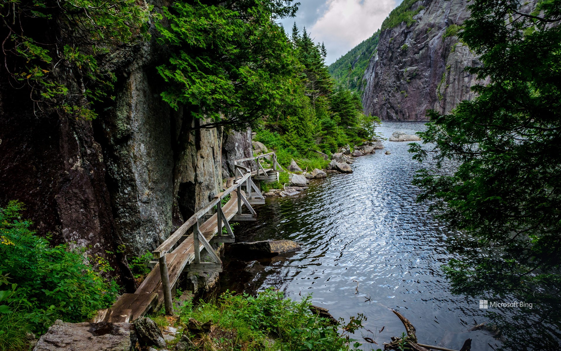
雪崩湖步道,阿迪朗达克高峰区,纽约州,美国 Avalanche Lake Trail at Adirondack High Peaks, New York (© Posnov/Getty Images)
溪流入梦 Stream a little dream
雪崩湖步道,阿迪朗达克高峰区,纽约州,美国
在这片高峰密布的区域,一座面积仅约9英亩的高山湖泊静静地坐落在近2,900英尺的海拔处,位于科尔登山与雪崩山之间。湖泊由远古冰川雕刻而成,四周环绕着陡峭的峭壁和崎岖的地形,清晰地保留着冰川时代留下的印记。其中最引人注目的地貌特征是“陷阱裂缝”,一条高达1,200英尺的岩石峡谷,峭壁险峻,是阿迪朗达克地区最令人震撼的自然奇观之一。正是过去发生的大规模雪崩,塑造了这一地形,也因此得名“雪崩湖”。 雪崩湖步道始于著名的阿迪朗达克小屋,这里是进入高峰区进行徒步、登山等户外活动的热门起点。全程约9.6英里,累计爬升约1,350英尺,虽然看似是一段轻松的行程,实则沿途地形复杂、变化多端,是对体力与意志的双重挑战。
Avalanche Lake Trail at Adirondack High Peaks, New York
There's no easing into the wild here—the Avalanche Lake Trail carves a bold path through rock scrambles, narrow ledges, and alpine serenity. Tucked away in New York's Adirondack High Peaks, this 9-acre alpine lake sits at nearly 2,900 feet between Mount Colden and Avalanche Mountain. Shaped by ancient glaciers, the lake is framed by dramatic cliffs and rugged terrain that echo its icy origins. Its most striking feature is the Trap Dike—a towering 1,200-foot rock canyon flanked by steep walls, making the lake one of the most awe-inspiring sights in the Adirondacks. Massive avalanches carved these cliffs, leaving behind the dramatic landscape that gave Avalanche Lake its name. The Avalanche Lake Trail begins at the Adirondack Loj, a well-known launch point for adventures in the High Peaks. Spanning about 9.6 miles round trip with a 1,350-foot elevation gain, the hike may seem manageable on paper—but it's the uneven terrain that truly tests your mettle.
灵维格灯塔,维泽桑讷,丹麦 Lyngvig Lighthouse, Hvide Sande, Denmark (© Caroline Brundle Bugge/Getty Images)
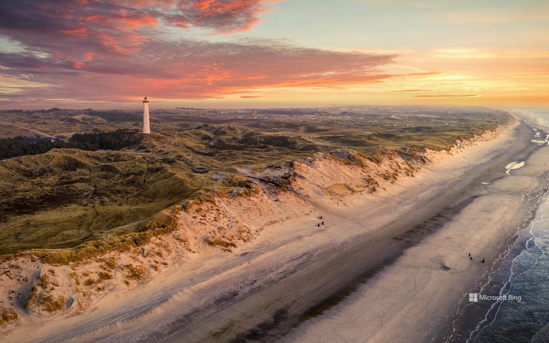
灵维格灯塔,维泽桑讷,丹麦 Lyngvig Lighthouse, Hvide Sande, Denmark (© Caroline Brundle Bugge/Getty Images)
眺望大海的高塔 One tall way to spot the sea
国际灯塔灯船周
为抵御风暴并引导船只安全靠岸,灯塔最初应运而生。如今,它们不仅是导航工具,更成为文化遗产、建筑奇迹和人类与海洋之间深厚联结的象征。每年 8 月的第三个周末,世界各地都会迎来“国际灯塔灯船周”活动,让人们齐聚一堂,共同庆祝这些海岸地标。该活动由苏格兰艾尔业余无线电小组成员约翰·福赛思和迈克·达尔里姆普尔于 1998年发起,旨在提高对灯塔与灯船保护的意识,同时推广业余无线电通信,并促进国际友好交流。
丹麦的林格维格灯塔便是传承这一精神的代表之一,正如今日图片所示。这座灯塔建于 1906 年,高达 120 英尺,矗立在日德兰半岛西海岸一处 55 英尺高的沙丘之上,是丹麦最西部的地标性建筑。它以混凝土为基底、砖墙构造,门窗采用耐候性强的柚木制成。最初由三名守塔人轮班维护灯光,直到 1965 年实现全自动化。尽管因结构安全问题在2024年一度暂停开放,如今它已完成修复,重新欢迎公众前来参观。
International Lighthouse Lightship Weekend
Built to brave storms and steer ships to safety, lighthouses now glow as symbols of heritage, wonder, and connection. Each year on the third weekend of August, the International Lighthouse Lightship Weekend brings together people from around the globe to celebrate these coastal icons. The event was launched in 1998 by John Forsyth and Mike Dalrymple of Scotland's Ayr Amateur Radio Group. It aims to raise awareness about preserving lighthouses and lightships while also promoting amateur radio and encouraging international goodwill.
Among the many lighthouses that carry this legacy forward is the Lyngvig Lighthouse in Denmark, featured here. Standing over 120 feet tall, this tower was built in 1906 atop a 55-foot dune along the west coast of Jutland—the country's westernmost region. Made with a concrete foundation and brick walls, and finished with teak-framed windows and doors, the lighthouse originally required a team of three keepers. They maintained its light until 1965. It has been operating automatically ever since. Following a temporary closure in 2024 due to structural concerns, the lighthouse is now open to the public again.
皮兹奈尔山缆车站, 格劳宾登州, 瑞士 Cable car station on Piz Nair mountain, Graubünden, Switzerland (© Roberto Moiola/Alamy)
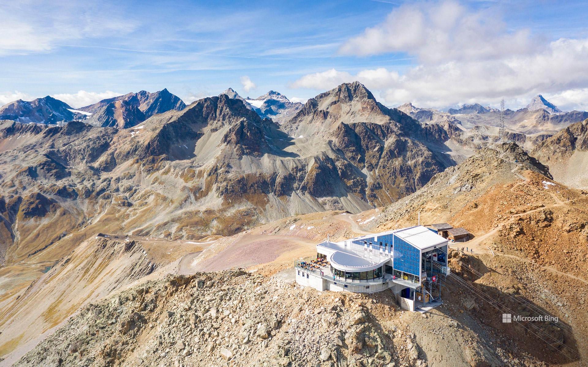
皮兹奈尔山缆车站, 格劳宾登州, 瑞士 Cable car station on Piz Nair mountain, Graubünden, Switzerland (© Roberto Moiola/Alamy)
皮兹奈尔山缆车站, 格劳宾登州, 瑞士
瑞士有一座山,它总是在俯瞰着你,但别太在意。皮茨奈尔峰坐落于阿尔布拉阿尔卑斯山脉,海拔高达10,026英尺,俯视着格劳宾登州的恩加丁山谷。从圣莫里茨出发,先乘坐缆索铁路抵达科尔维利亚,再换乘缆车直达山顶。登顶后,等待你的是观景平台、著名的阿尔卑斯野山羊雕像,以及一间独具特色的玻璃立方体餐厅,在这里可享受 360 度全景用餐体验。
这座高山曾在1948年冬奥会上大放异彩,如今仍拥有瑞士最著名的滑雪道之一。“皮茨奈尔壁”以其极具挑战性的高山速降而闻名,2003年世界锦标赛速降项目也曾在此举办。进入夏季,积雪融化,但登山路线依然备受欢迎。徒步爱好者与山地车骑手纷至沓来,探索高山草甸,在寂静与辽阔中沉醉。得益于导览服务和完善的路径指示,游客可轻松踏上这场旅程。无论你追求的是皑皑雪景、灿烂阳光,还是只想逃离海平面的日常,皮茨奈尔都能让你真正体验一场“高处不胜寒”的精神洗礼。
Cable car station, Graubünden, Switzerland
There's a mountain in Switzerland that's always looking down on you—but don't take it personally. At 10,026 feet, Piz Nair of the Albula Alps keeps an eye over the Engadine valley in Graubünden. Start in St. Moritz: hop on the funicular (a type of cable railway system) to Corviglia, then ride the cable car to the summit. At the top? A viewing platform and that famous ibex (an alpine goat) statue. There's also a restaurant where you can eat inside a glass cube with 360° views.
This alpine peak hosted the 1948 Winter Olympics and still boasts some of the most famous ski runs in the country. The 'Piz Nair Wall' is known for its challenging downhill skiing and events like the 2003 World Championship downhill race. Come summer, the snow clears but the trails stay hot. Hikers and mountain bikers flock here to explore alpine meadows, and soak in a different kind of silence. Guided tours and well-marked paths make it easy to find your footing. So, whether you're chasing snow, sun, or just a break from sea-level boredom, this Swiss giant will lift your spirits—literally.
一名男子从摩押附近的科罗纳拱门索降, 美国 A man rappels off Corona Arch near Moab, Utah (© Grant Ordelheide/TANDEM Stills + Motion)
一名男子从摩押附近的科罗纳拱门索降, 美国 A man rappels off Corona Arch near Moab, Utah (© Grant Ordelheide/TANDEM Stills + Motion)
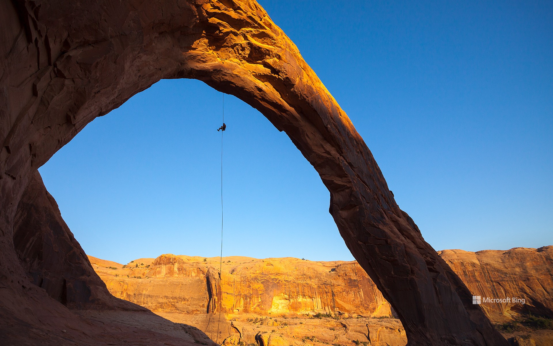
地球的公开秘密 Earth's open secret
摩押附近的科罗纳拱门,犹他州
通往它的科罗纳拱门步道起初较为平坦,但沿途风光壮丽:穿越铁路轨道、攀爬光滑岩石,甚至需借助金属缆绳前行,让这段旅程远不只是一次在犹他州拱门国家公园之外,有一处如同通向天空的巨大门户般的自然奇观,吸引着摄影师、自然爱好者和徒步旅行者,那就是今日图片中所见的科罗纳拱门。这座巨大拱形岩石由纳瓦霍砂岩构成,是一处充满冒险却不拥挤的旅行目的地。普通的沙漠散步。步行约1.5英里后,你将抵达这座令人震撼的天然拱门,它宽达140英尺,高约105英尺,庞大的规模令人叹为观止。过去曾有人在拱门上系绳荡秋千,这种极限活动后来因安全原因被禁止。即便没有刺激的冒险,这次徒步旅程仍能让你在红岩地貌的心脏地带,欣赏到令人震撼的自然景观,留下难忘回忆。科罗纳拱门也被称为“小彩虹桥”,因其外形酷似鲍威尔湖附近的著名彩虹桥,但它独自坐落于更为宁静的天地之中,绽放着独特的自然魅力。
Corona Arch near Moab, Utah
Just outside Arches National Park in Utah lies a natural wonder that rises like a colossal doorway against the sky, drawing photographers, nature lovers, and hikers. Welcome to Corona Arch, seen in today's image, a towering Navajo sandstone formation that offers big adventure without the big crowds. The Corona Arch Trail starts off easy but packs a punch of scenery: railroad tracks, slickrock scrambles, and even a metal cable assist make it more than just a walk in the desert. After 1.5 miles of walking, the payoff is big: a massive arch that's 140 feet wide and 105 feet high. It's so large that people once swung from it on ropes, until that was banned for safety reasons. Even without the adrenaline stunts, the hike offers beautiful views and unforgettable moments in the heart of Red Rock Country. Also known as Little Rainbow Bridge, it shares visual similarities with the iconic Rainbow Bridge arch near Lake Powell—but Corona Arch holds its own in a more peaceful setting.