2022年3月
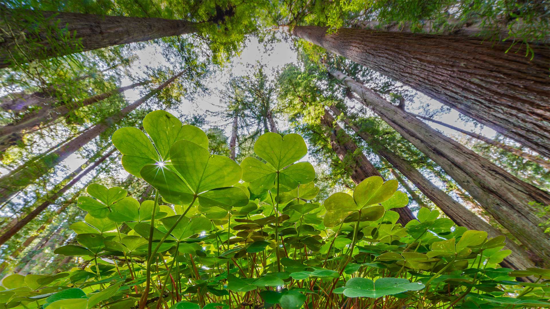
生机盎然的酢浆草和红杉树,美国大草原溪红杉州立公园 Coastal redwoods and wood sorrel, Prairie Creek Redwoods State Park, California (© Jack Dykinga/Minden Pictures)
生机盎然的酢浆草和红杉树,美国大草原溪红杉州立公园 Coastal redwoods and wood sorrel, Prairie Creek Redwoods State Park, California (© Jack Dykinga/Minden Pictures)
有四叶草吗? Any with four leaves?
St. Patrick's Day
Ireland has been called the land of '40 shades of green,' but this green leprechaun's-eye view comes from the feet of California's giant sequoias. Today we celebrate St. Patrick, the patron saint of Ireland, who famously never traveled to California. St. Patrick is often depicted holding a shamrock, which he purportedly used to spread Christianity in Ireland by saying the leaves illustrated the Father, Son, and the Holy Spirit of the Holy Trinity. Never mind that Celtic druids had revered the sacred shamrock and its three leaves long before Patrick's arrival. Coins depicting St. Patrick with a shamrock date back as far as 1675.
Legends of St. Patrick abound. For example, he's said to have driven the snakes out of Ireland, but most experts would suggest it was the cool, damp weather that kept the serpents from ever arriving there in the first place. Tradition has it that he died on March 17 of the year 461 CE, and one can only assume that a year later the first green beer was served.
Whether you find yourself in Dublin, the California coast, or any point in between today, we leave you with a traditional Irish toast: 'May your glass be ever full. May the roof over your head be always strong. And may you be in heaven half an hour before the devil knows you're dead.'
圣帕特里克节
爱尔兰被称为“40种绿荫之地”,但这张绿色小妖精的视线来自加利福尼亚州巨大红杉的脚下。今天,我们庆祝爱尔兰的守护神圣帕特里克,他以从未去过加利福尼亚而闻名。圣帕特里克经常被描绘成手持三叶草,据说他用三叶草在爱尔兰传播基督教,说三叶草描绘了圣父、圣子和三位一体的圣灵。在帕特里克到来之前很久,凯尔特德鲁伊就已经崇敬了神圣的三叶草和它的三片叶子。描绘圣帕特里克和三叶草的硬币可以追溯到1675年。
圣帕特里克的传说比比皆是。例如,据说他把蛇赶出了爱尔兰,但大多数专家认为,正是凉爽潮湿的天气阻止了蛇从一开始就到达那里。按照传统,他于公元461年3月17日去世,人们只能假设一年后,第一瓶绿色啤酒出现了。
无论你是在都柏林、加利福尼亚海岸,还是在这两者之间的任何时刻,我们都会给你一个传统的爱尔兰祝酒词:“愿你的酒杯永远充满。”。愿你头上的屋顶永远坚固。愿你在魔鬼知道你死前半小时就到了天堂。
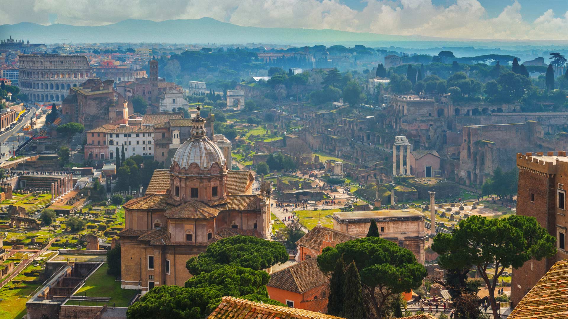
古罗马广场,意大利 The Roman Forum, Rome, Italy (© Peter Zelei Images/Getty Images)
古罗马广场,意大利 The Roman Forum, Rome, Italy (© Peter Zelei Images/Getty Images)
前往罗马广场的路上发生了一件趣事…… A funny thing happened on the way to the Forum…
Beware the ides of March
We're at the Roman Forum, or Forum Romanum, for the ides of March, a day made famous as the site of the assassination of Julius Caesar. While Shakespeare's Caesar was warned to 'beware the ides of March,' historians have never attributed the phrase to those who tipped off the actual Caesar about a plot against him. We do know that before March 15, 44 BCE was over, Caesar was assassinated. Afterward, Rome descended into war, ending the Roman Republic, and leading to the rise of the Roman Empire.
The Forum was a city square in which Rome's commercial, political, and religious activity took place, along with the occasional assassination. It was a site of ceremonies and celebrations. It was where Mark Antony's famed funeral oration for Caesar was given, and where Caesar's body was burned before the public. Today the area is a popular tourist attraction, drawing more than 4.5 million visitors in an average year.
当心三月的天气
我们在罗马论坛,或罗马论坛,为三月的ides,这一天作为朱利叶斯·凯撒遇刺的地点而闻名。虽然莎士比亚的凯撒被警告要“当心三月的末日”,但历史学家从未将这句话归因于那些向真正的凯撒透露了针对他的阴谋的人。我们知道,在公元前44年3月15日之前,凯撒被暗杀。后来,罗马陷入战争,结束了罗马共和国,并导致罗马帝国的崛起。
该论坛是一个城市广场,罗马的商业、政治和宗教活动以及偶尔发生的暗杀都在这里进行。这是一个举行仪式和庆祝活动的地方。在这里,马克·安东尼为凯撒举行了著名的葬礼演讲,凯撒的遗体在公众面前被焚毁。如今,该地区是一个受欢迎的旅游景点,平均每年吸引450多万游客。
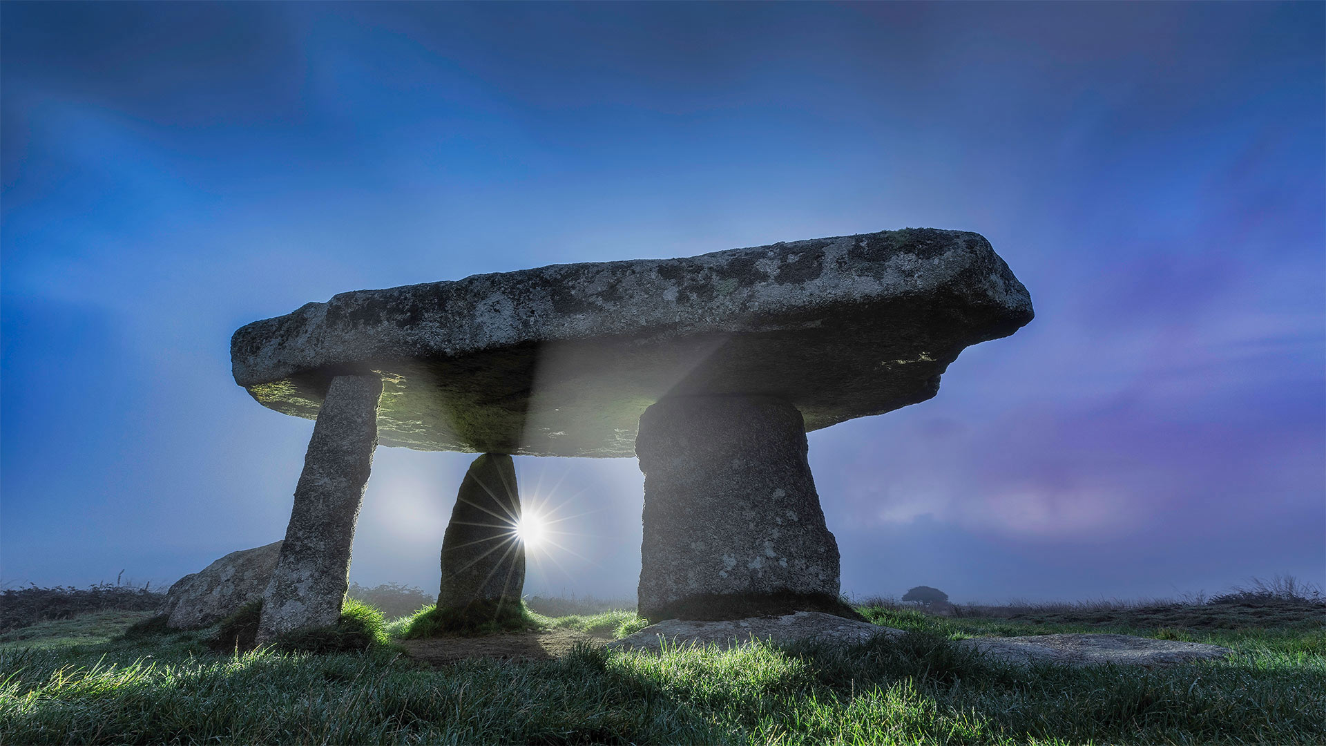
兰洋夸特墓室,英国康沃尔郡 Lanyon Quoit burial chamber, Cornwall, England (© Guy Edwardes/Minden Pictures)
兰洋夸特墓室,英国康沃尔郡 Lanyon Quoit burial chamber, Cornwall, England (© Guy Edwardes/Minden Pictures)
天空中的圆周率...... It's just pi in the sky...
Pi Day
Did Neolithic humans build this structure to celebrate Pi Day? Not likely. Pi Day is a relatively recent phenomenon—invented by a physicist in 1988 and designated by Congress a national holiday in 2009. But it's already almost certainly the most popular holiday celebrating a mathematical constant. While Pi Day is a young tradition, the number π (pi) itself has been a fascination since antiquity, when it was first calculated as the ratio of a circle's circumference to its diameter.
You probably know that March 14 was chosen for Pi Day since the date expressed numerically (in month/date format) matches the number's first digits, 3.14. Aside from eating pie to celebrate, some people go to great lengths to memorize digits that go way beyond 3.141592…, which earns them bragging rights in some, um, circles. The world record is a staggering 70,000 digits after the decimal point—the remarkable feat was achieved by 21-year-old student Rajveer Meena in 2015.
Take a moment from your Pi Day revelry to appreciate the unintentional π symbol formed by this Neolithic burial chamber in Cornwall, England. As the morning sun warms Lanyon Quoit's ancient stones, it's impossible not to wonder who built it and how, since it predates metal tools and is older than Egypt's pyramids. Theories abound, of course, but could π have been involved?
圓周率日
新石器时代的人类建造这个建筑是为了庆祝圆周率日吗?不太可能。圆周率日是一个相对较新的现象,由物理学家在1988年发明,并在2009年被国会指定为全国性节日。但几乎可以肯定,这已经是庆祝数学常数最受欢迎的节日。虽然圆周率日是一个年轻的传统,但从远古时代开始,圆周率(Pi)本身就一直是一个令人着迷的数字,当时它最初被计算为圆的周长与直径之比。
你可能知道,3月14日被选为圆周率日,因为数字表示的日期(月/日格式)与数字的第一位数字3.14匹配。除了吃馅饼庆祝外,有些人会不遗余力地记住远远超过3.141592的数字,这让他们在一些圈子里大肆吹嘘。这项世界纪录在小数点后达到了令人震惊的70000位。这项了不起的壮举是由21岁的学生拉杰维尔·米娜在2015年创造的。
从你的π日狂欢中抽出一点时间,欣赏一下英格兰康沃尔新石器时代墓室无意中形成的π符号。当早晨的阳光温暖着拉尼恩·库伊特的古老石头时,我们不可能不去想它是谁建造的,是如何建造的,因为它比金属工具更早,比埃及的金字塔还要古老。当然,各种理论比比皆是,但π是否也会参与其中呢?
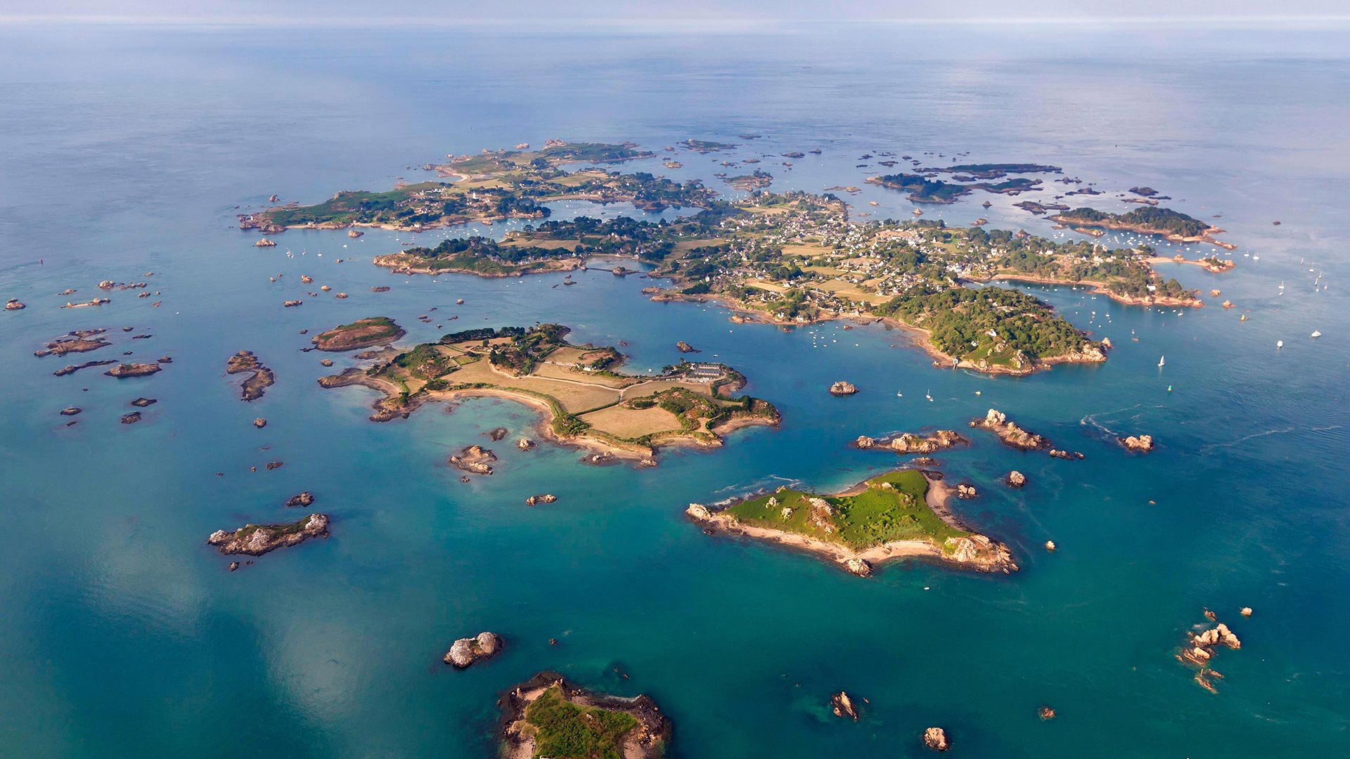
鸟瞰视角下的布雷阿岛,法国阿摩尔滨海省 Aerial view of Bréhat island, Côtes-d'Armor, France (© LECLERCQ Olivier/hemis.fr/Alamy)
鸟瞰视角下的布雷阿岛,法国阿摩尔滨海省 Aerial view of Bréhat island, Côtes-d'Armor, France (© LECLERCQ Olivier/hemis.fr/Alamy)
布列塔尼!Brittany!
Bréhat island
Brittany wins us over! Today head to the Bréhat archipelago, made up of the main island and 86 neighboring islets and reefs. On July 13, 1907, Bréhat became the first natural site classified in France! 3.5 kilometers long and 1.5 kilometers wide, the island is accessible by boat and can be visited on foot or by bicycle. You will discover here a multitude of coves, beaches, and shelters for lost sailors. If you are planning a trip to the island, then we suggest you go in spring or autumn: there are fewer people, the weather remains mild and nature is lush.
All year round, the archipelago benefits from the influence of the Gulf Stream, which provides it with a particularly mild microclimate in winter. Many varieties of flowers color the island: exotic plants such as agave or echium; flowers like the hydrangea, the mimosa, the mulberry, the eucalyptus, the aloe, or the camellia… But the flower that most symbolizes Bréhat is the agapanthus which blooms from April to September and colors the paths with its hue blue-purple.
Traveling through Bréhat, you discover a rich and varied heritage that traces the maritime and military history that marked the island. In the past, Bréhat provided the crown of France with numerous corsairs that caused terror to reign over the Atlantic. Thus, there are monuments such as the Pont ar Prad built by Vauban, It was built to connect the two islands forming Bréhat and a citadel which today houses the Verreries de Bréhat.
布莱哈特岛
布列塔尼赢了我们!今天,前往布莱哈特群岛,该群岛由主岛和86个相邻的岛屿和珊瑚礁组成。1907年7月13日,布莱哈特成为法国第一个自然遗址!该岛长3.5公里,宽1.5公里,可乘船前往,可步行或骑自行车前往。你会在这里发现许多海湾、海滩和迷路水手的庇护所。如果你计划去这个岛旅行,那么我们建议你在春天或秋天去:那里的人少了,天气依然温和,自然繁茂。
该群岛全年都受益于墨西哥湾流的影响,这为它提供了一个特别温和的冬季小气候。岛上有许多不同种类的花:奇异的植物,如龙舌兰或刺五加;绣球花、含羞草、桑树、桉树、芦荟或茶花……但最能象征百日咳的花是阿伽潘托斯,它从4月到9月开花,并以蓝紫色将道路染成蓝色。
穿过布雷哈特,你会发现一个丰富多样的遗产,可以追溯该岛的海洋和军事历史。在过去,布莱哈特为法国王冠提供了无数海盗船,这些海盗船在大西洋上空制造了恐怖。因此,这里有一些纪念碑,比如沃班建造的阿尔普拉德桥,它是为了连接两个岛屿而建造的,形成了布雷哈特岛和一座城堡,今天这里有布雷哈特城堡。
奥卡拉国家森林中的杜松泉,美国佛罗里达州 Juniper Springs in Ocala National Forest, Florida (© Michael Warren/Getty Images)
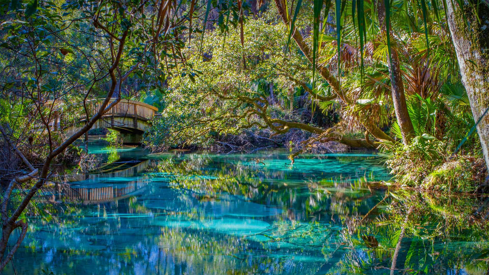
奥卡拉国家森林中的杜松泉,美国佛罗里达州 Juniper Springs in Ocala National Forest, Florida (© Michael Warren/Getty Images)
全年均可在此畅游 You can take a refreshing dip here any day of the year
Juniper Springs, Florida
Yes, the water here is as inviting as it looks: clear as glass, the shade of a precious gem, and a perfect 73 degrees every day of the year. Set within a subtropical forest, it is a veritable Garden of Eden. Long before Disney arrived in the Sunshine State, natural springs like this one were what visitors flocked to. Juniper Springs, seen here, is one of Florida's oldest and best-known recreation areas, established in the 1930s as a place to camp, hike, paddle, and, of course, swim.
Florida is home to the largest concentration of freshwater springs in the world, with more than 1,000 of them scattered mostly across the upper part of the state, where the massive Floridan aquifer breaks through the surface. This underground reservoir hides beneath the entire state and parts of neighboring states. Under constant pressure, the water sometimes reaches voids in the surface, and a spring is created. This aquifer provides Florida with almost all its drinking water.
Like so many of our natural resources, Florida's springs are under threat. Overextraction and pollution from fertilizers and septic systems have put some springs in peril. Luckily for anyone visiting Juniper Springs, these jewel-toned waters are protected by the Ocala National Forest, so it's likely to look like this for a long time.
佛罗里达州杜松斯普林斯
是的,这里的水和它看起来一样诱人:清澈如玻璃,宝石般的阴影,一年中每天都有完美的73度。它坐落在亚热带森林中,是名副其实的伊甸园。早在迪士尼抵达阳光之州之前,像这样的天然泉水就是游客们蜂拥而来的地方。这里所见的刺柏泉是佛罗里达州最古老、最著名的休闲区之一,建于20世纪30年代,是露营、徒步旅行、划桨,当然还有游泳的地方。
佛罗里达州是世界上淡水泉最集中的地方,其中1000多处主要分布在佛罗里达州的上半部分,那里巨大的弗洛里丹含水层穿透地表。这个地下水库隐藏在整个州和邻近州的部分地区之下。在恒定的压力下,水有时会到达表面的空隙,从而产生一个弹簧。该含水层为佛罗里达州提供了几乎所有的饮用水。
和我们的许多自然资源一样,佛罗里达州的泉水也受到威胁。肥料和化粪池系统的过度抽取和污染已经使一些泉水处于危险之中。幸运的是,对于任何参观Juniper Springs的人来说,这些宝石色的水域都受到奥卡拉国家森林的保护,所以很可能很长一段时间都是这样。
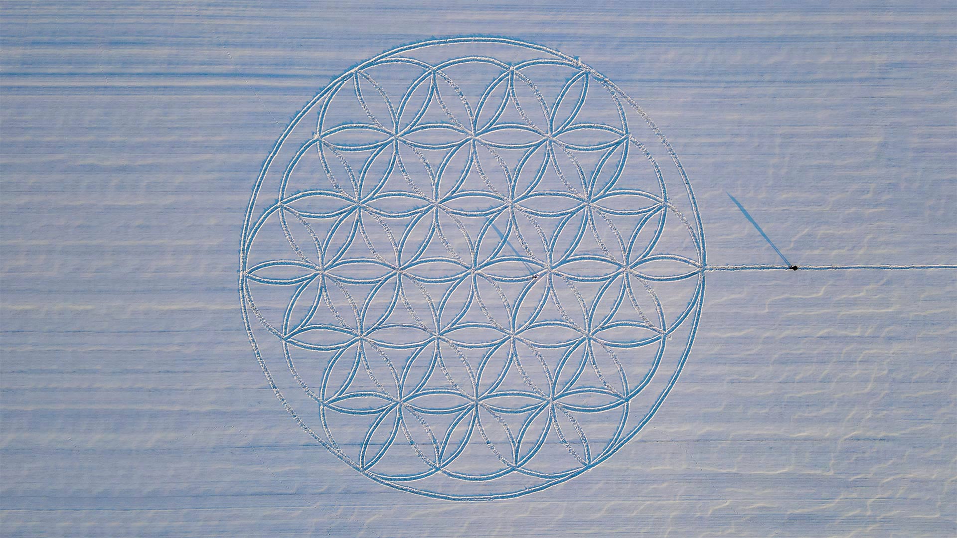
艺术家迈克尔·乌伊在雪地上绘制的“生命之花”符号, 德国勃兰登堡雅各布斯多夫 The 'Flower of Life' symbol drawn in the snow by artist Michael Uy, Jacobsdorf, Brandenburg, Germany (© Patrick Pleul/picture alliance via Getty Images)
艺术家迈克尔·乌伊在雪地上绘制的“生命之花”符号, 德国勃兰登堡雅各布斯多夫 The 'Flower of Life' symbol drawn in the snow by artist Michael Uy, Jacobsdorf, Brandenburg, Germany (© Patrick Pleul/picture alliance via Getty Images)
Flower of Life symbol drawn in snow
German artist Michael Uy created this 'Flower of Life' geometric pattern in the snow in Brandenburg. Preparations began about a week before the snow's arrival, when Uy hammered 19 wooden posts into a field, carefully measuring the space between each post. After the snowfall, he walked near-perfect circles around all 19 pillars, using a string to keep an equal distance from the posts. The artist then used a broom to further remove the snow from his footprints and reveal the lines of the flower nearly 200 feet across. Uy's piece was fully visible only when the sun was low. And only until the next snow or warm day. Luckily, a drone was dispatched to snap this photograph.
The 'Flower of Life' is an ancient symbol long revered by various cultures around the world, from ancient Assyrians to modern pagans. The pattern is believed by some to be a visual representation of interconnectivity, energy, and harmony, by others to be a key to unlocking secrets of the universe. And hey, it looks cool. Especially on ice.
生命之花的象征画在雪地上
德国艺术家迈克尔·乌伊(Michael Uy)在勃兰登堡(Brandenburg)的雪中创造了这种“生命之花”几何图案。准备工作在大雪到来前大约一周开始,Uy将19根木桩锤入一块场地,仔细测量每根木桩之间的间距。下雪后,他绕着所有19根柱子几乎完美地走了一圈,用绳子与柱子保持相等的距离。然后,艺术家用扫帚进一步清除脚印上的积雪,并展示了近200英尺宽的花朵线条。乌伊的作品只有在太阳很低的时候才完全可见。直到下一场雪或温暖的一天。幸运的是,一架无人机被派去拍这张照片。
“生命之花”是一种古老的象征,从古代亚述人到现代异教徒,世界各地的各种文化都长期尊崇它。一些人认为这种模式是互联、能量和和谐的视觉表现,另一些人则认为它是解开宇宙秘密的钥匙。嘿,看起来很酷。尤其是在冰上。
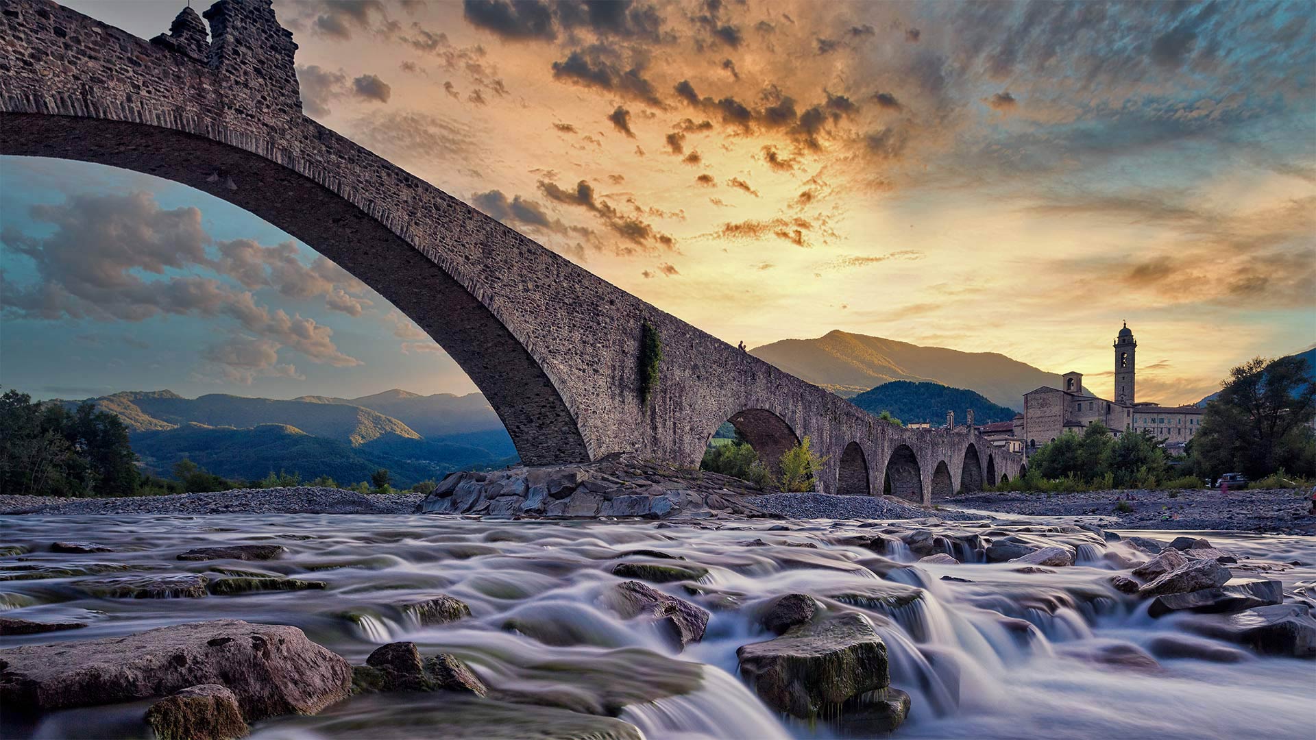
Ponte Gobbo桥,意大利博比奥 Ponte Vecchio bridge near Bobbio, Italy (© afinocchiaro/Getty Images)
Ponte Gobbo桥,意大利博比奥 Ponte Vecchio bridge near Bobbio, Italy (© afinocchiaro/Getty Images)
特雷比亚河的左岸便是 On the left bank of the river Trebbia, lies...
Bobbio, Italy
Between the metropolis of Milan—the fashion and design capital of Italy—and the fabled seaport city of Genoa, you'll find this small river town in northern Italy. People have resided here since ancient times, including the Romans, but the town really began to flourish when the abbey was constructed in the 7th century. For much of the Middle Ages, the Bobbio Abbey and its vast library made the town a center of religion, culture, and learning.
These days, Bobbio is a regular tourist stop perhaps best known for its old bridge, or Ponte Vecchio (not to be confused with THE Ponte Vecchio in Florence). Bobbio's old bridge spans the river Trebbia with 11 arches of unequal size and is commonly called Ponte Gobbo (Hunchback Bridge), because of its irregular shape.
Bobbio remains a jewel box of a town frozen in time. With its many small churches, modest houses, and cobblestone streets, Bobbio maintains the character of a medieval village nestled the Trebbia valley. Ernest Hemingway described the Val Trebbia as 'the most beautiful in the world,' and with views like this, who could argue with him?
意大利博比奥
在意大利时尚和设计之都米兰和传说中的海港城市热那亚之间,你会发现这个意大利北部的小河镇。自古以来,这里就有人居住,包括罗马人,但当修道院于7世纪建成时,这座城镇真正开始繁荣起来。在中世纪的大部分时间里,博比奥修道院及其巨大的图书馆使该镇成为宗教、文化和学习的中心。
如今,博比奥是一个固定的旅游站,也许最著名的是它的老桥,或者叫Vecchio桥(不要和佛罗伦萨的Vecchio桥混淆)。博比奥的旧桥横跨特雷比亚河,有11座大小不等的拱门,因其形状不规则,通常被称为“驼背桥”(Ponte Gobbo)。
博比奥仍然是一个被时间冻结的城镇的珠宝盒。博比奥有许多小教堂、简陋的房屋和鹅卵石街道,保持着特雷比亚山谷一个中世纪村庄的特色。欧内斯特·海明威(Ernest Hemingway)将瓦尔·特雷比娅(Val Trebbia)描述为“世界上最美的”,有这样的观点,谁能和他争论呢?
蒂内河畔圣艾蒂安小镇,法国阿尔卑斯省 France, Alpes Maritimes Mercantour National Park, Tinée Vallée, Saint-Etienne-de-Tinée (© CAVALIER Michel/hemis.fr/Alamy Stock Photo)
蒂内河畔圣艾蒂安小镇,法国阿尔卑斯省 France, Alpes Maritimes Mercantour National Park, Tinée Vallée, Saint-Etienne-de-Tinée (© CAVALIER Michel/hemis.fr/Alamy Stock Photo)
征服了世界的高山 The mountain wins us over
Saint-Étienne-de-Tinée
Today, head to the Alpes Maritime, in Saint-Etienne-de-Tinée. This small village in the Mercantour National Park, built on the banks of the river and in the hollow of a wide sunny valley, offers a pleasant and peaceful quality of life to residents and holidaymakers. As you stroll through the streets of the village, let yourself be guided by the testimonies of the past: pastel-colored facades, perspective wall paintings, sundials and fountains and much more. If you are lucky enough to be able to push the door of the parish church or the 7 listed chapels, you will discover a religious heritage of great beauty, in particular the murals that attract art lovers from all over the world.
Less than 10 kilometers away, you will find the village resort of Auron which offers a real change of scenery through its undeniable charm. Its beautiful residences, its luxurious chalets, or its traditional barns renovated into magnificent dwellings respect the architecture of its heritage jewel, the St Erige chapel, a listed building that is the pride of the inhabitants of the village. You will appreciate the central square that encircles the ice rink, the cradle of all entertainment and parties after skiing.
For lovers of mountain nature, whether summer or winter, exploring the entire Mercantour National Park is an absolute must. This territory shelters a space of harmony between protection, discovery, local development and respect for traditional activities. Nature deserves attention and respect everywhere: here we admire rather than pick, we observe discreetly without disturbing. The Tinée valley, where today's photo was taken, stretches for around 80 kilometers, from its confluence with the Var, to the sources of the Tinée at the foot of the Col de la Bonette.
圣埃蒂安·德蒂内
今天,前往圣艾蒂安·德·蒂涅的阿尔卑斯海岸。这座位于墨卡托国家公园的小村庄建在河岸上,坐落在一个阳光普照的宽阔山谷的山谷中,为居民和度假者提供了一种愉快而平和的生活质量。当你漫步在村庄的街道上时,让自己被过去的见证所引导:柔和的彩色外墙、透视壁画、日晷和喷泉等等。如果你足够幸运,能够推开教区教堂或列出的7座小教堂的门,你会发现一个非常美丽的宗教遗产,尤其是吸引世界各地艺术爱好者的壁画。
在不到10公里的地方,你会发现奥隆村度假村,它以其无可否认的魅力为你带来了真正的风景变化。它美丽的住宅、豪华的小屋,或被翻新成华丽住宅的传统谷仓,都尊重它的遗产珍宝圣埃里日教堂的建筑,这是一座名单上的建筑,是该村居民的骄傲。你会欣赏环绕着溜冰场的中央广场,它是滑雪后所有娱乐和派对的摇篮。
无论是夏天还是冬天,对于热爱山地自然的人来说,探索整个梅坎托国家公园绝对是必须的。这片土地在保护、发现、当地发展和尊重传统活动之间提供了一个和谐的空间。大自然在任何地方都值得关注和尊重:在这里,我们欣赏而不是挑选,我们谨慎地观察而不打扰。拍摄今天照片的蒂涅河谷绵延约80公里,从它与瓦尔河的交汇处,一直延伸到博内特山脚下的蒂涅源头。
以新西兰南岛奥拉基/库克山国家公园为背景的特卡波湖 Lake Tekapo with Aoraki/Mount Cook National Park in the background on New Zealand's South Island (© Sophie Dover/Getty Images) (© Sophie Dover/Getty Images)
以新西兰南岛奥拉基/库克山国家公园为背景的特卡波湖 Lake Tekapo with Aoraki/Mount Cook National Park in the background on New Zealand's South Island (© Sophie Dover/Getty Images) (© Sophie Dover/Getty Images)
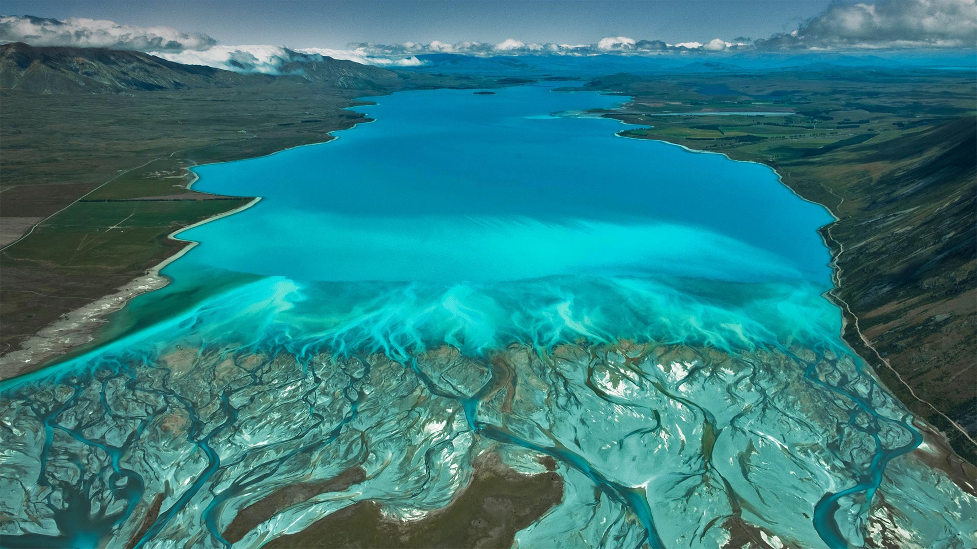
蓝色新西兰 Blue Zealand
Lake Tekapo, New Zealand
The striking electric-blue waters of Lake Tekapo are caused by extremely finely ground rock particles suspended in the melted waters of glaciers in the nearby Southern Alps. Snowmelt from the range feeds two similarly stunning lakes in the Mackenzie Basin of New Zealand's South Island, Lake Pukaki and Lake Ohau, which share their neighbor's remarkable turquoise color and mountainous backdrops. New Zealand's highest peak, Aoraki/Mount Cook, reigns in Mount Cook National Park, seen in the background of this image.
The name Tekapo is a misspelling of the Māori word Takapō, which means 'to leave in haste at night.' But if you are one of the region's many visitors, you may find the nighttime even more mesmerizing than the day. Lake Tekapo is a certified Dark Sky Reserve, one of the world's largest. With night skies almost completely free of light pollution, stargazing doesn't get much more vibrant, and tours cater to manuhiri (visitors) interested in astro-tourism. If that's not reason enough to stay the night, the area's abundant skiing and fishing opportunities might be. There's certainly no need to leave in a rush.
新西兰特卡波湖
特卡波湖惊人的电蓝色海水是由悬浮在附近南阿尔卑斯山冰川融化水中的极细的岩石颗粒造成的。来自该山脉的融雪为新西兰南岛麦肯齐盆地的两个同样令人惊叹的湖泊——普卡基湖和奥豪湖提供了水源,这两个湖泊共享着其邻居引人注目的绿松石色和多山的背景。新西兰最高峰奥拉基/库克山位于库克山国家公园,如图背景所示。
Tekapo这个名字是毛利人单词Takapō的拼错,意思是“晚上匆忙离开”但如果你是该地区众多游客中的一员,你可能会发现夜间比白天更迷人。特卡波湖是世界上最大的黑天空保护区之一。由于夜空几乎完全没有光污染,观星活动也没有变得更加活跃,旅游也迎合了对天文旅游感兴趣的游客。如果这还不足以作为过夜的理由,那么该地区丰富的滑雪和钓鱼机会可能会更大。当然没有必要匆忙离开。
圣米歇尔山,法国诺曼底 The island of Mont-Saint-Michel in Normandy, France (© DaLiu/Getty Images)
圣米歇尔山,法国诺曼底 The island of Mont-Saint-Michel in Normandy, France (© DaLiu/Getty Images)
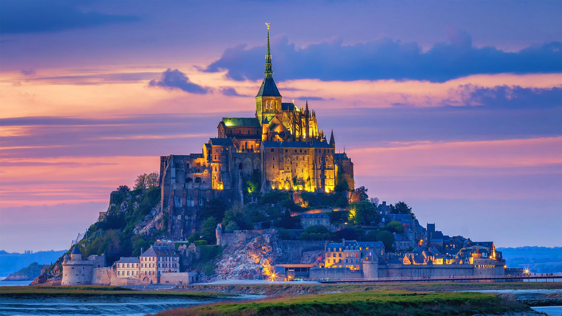
一个神圣的愿望孕育了第一个小教堂 A saintly vision inspired the first chapel
Mont-Saint-Michel
The stunning sight of Mont-Saint-Michel rising out of the bay is unforgettable. And visiting the island will be too, if you time it right. The paved causeway is accessible only when the tide is out; otherwise, you're at the mercy of the muddy flats, dangerous quicksand, and the quickly rising tide.
Today's visitors are following in the footsteps of pilgrims who for centuries traversed Europe to pray at the sacred site. The local bishop of Avranches built a chapel on this rock in 708 after the archangel St. Michael visited him in a dream, and the rest, as they say, is history. Now the island, half a mile off the coast of Normandy in northwestern France, is a UNESCO World Heritage Site. Its permanent population is fewer than 50 people, including a dozen or so monks and nuns, but more than 3 million visitors cross over to the island most years.
圣米歇尔山
圣米歇尔山从海湾升起的壮观景象令人难忘。如果时间合适的话,去岛上游玩也会很愉快。铺砌的堤道只有在退潮时才能到达;否则,你将任由泥泞的平地、危险的流沙和快速上涨的潮水摆布。
今天的游客正追随几个世纪以来穿越欧洲、在圣地祈祷的朝圣者的脚步。公元708年,大天使圣迈克尔在梦中拜访了阿夫兰切斯的当地主教,之后他在这块岩石上修建了一座小教堂,其余的,正如他们所说的,已经成为历史。现在,这个岛距离法国西北部诺曼底海岸半英里,是联合国教科文组织的世界遗产。该岛的常住人口不到50人,其中包括十几名僧侣和尼姑,但大多数年份有300多万游客前往该岛。