詹姆斯·韦伯太空望远镜观测的创生之柱 The Pillars of Creation viewed by the James Webb Space Telescopev (© NASA)

詹姆斯·韦伯太空望远镜观测的创生之柱 The Pillars of Creation viewed by the James Webb Space Telescope (© NASA)
宇宙在绽放 Universe in bloom
太空周还没结束呢!
随着世界空间周接近尾声,宇宙依然不断给予我们仰望的理由。想象一下云朵——不是在天空中飘动,而是在浩瀚星海中延展,孕育着新星的诞生。这正是NASA的詹姆斯·韦布太空望远镜所捕捉到的“创生之柱”景象。如图所示,色彩与细节前所未见,令人震撼。
这些巨大的尖塔状结构,从左下角斜伸至右上角,几乎完全由尘埃和气体构成,这里正是恒星诞生的摇篮。在这些巍峨的结构内部,引力紧紧束缚着团块状的物质,逐步引发燃烧,从而孕育出新的恒星,它们已在柱体边缘闪烁生辉。令人惊叹的是,这一宇宙奇观正发生在距我们仅6500光年的鹰状星云中。这些柱体隐藏在遮蔽遥远宇宙的厚重星际云带之后,却依然绽放着璀璨的光芒,成为星云的焦点所在。
Space Week isn't over yet!
As World Space Week draws to a close, the cosmos continues to give us reasons to look up in awe. Picture clouds—not drifting across our skies, but stretching across space itself, cradling the birth of new stars. That's exactly what NASA's James Webb Space Telescope has revealed in its view of the Pillars of Creation—shown here—with colors and details unlike anything seen before.
These massive, spire-like structures—rising diagonally from bottom left to the top right—are composed almost entirely of dust and gas, the very seedbed of stars. Within these towering formations, gravity tightens its grip on knots of material, sparking gradual ignition and birthing new stars that already shimmer along the pillars' edges. Remarkably, this celestial performance is taking place just 6,500 light-years away, within the Eagle Nebula. Hidden behind thick lanes of interstellar clouds that mask the distant universe, the pillars emerge in full glory, shining front and center.
里奇韦附近斯内弗尔斯山脚下的秋色, 科罗拉多州, 美国 Fall colors below Mount Sneffels near Ridgway, Colorado (© Grant Ordelheide/TANDEM Stills + Motion)
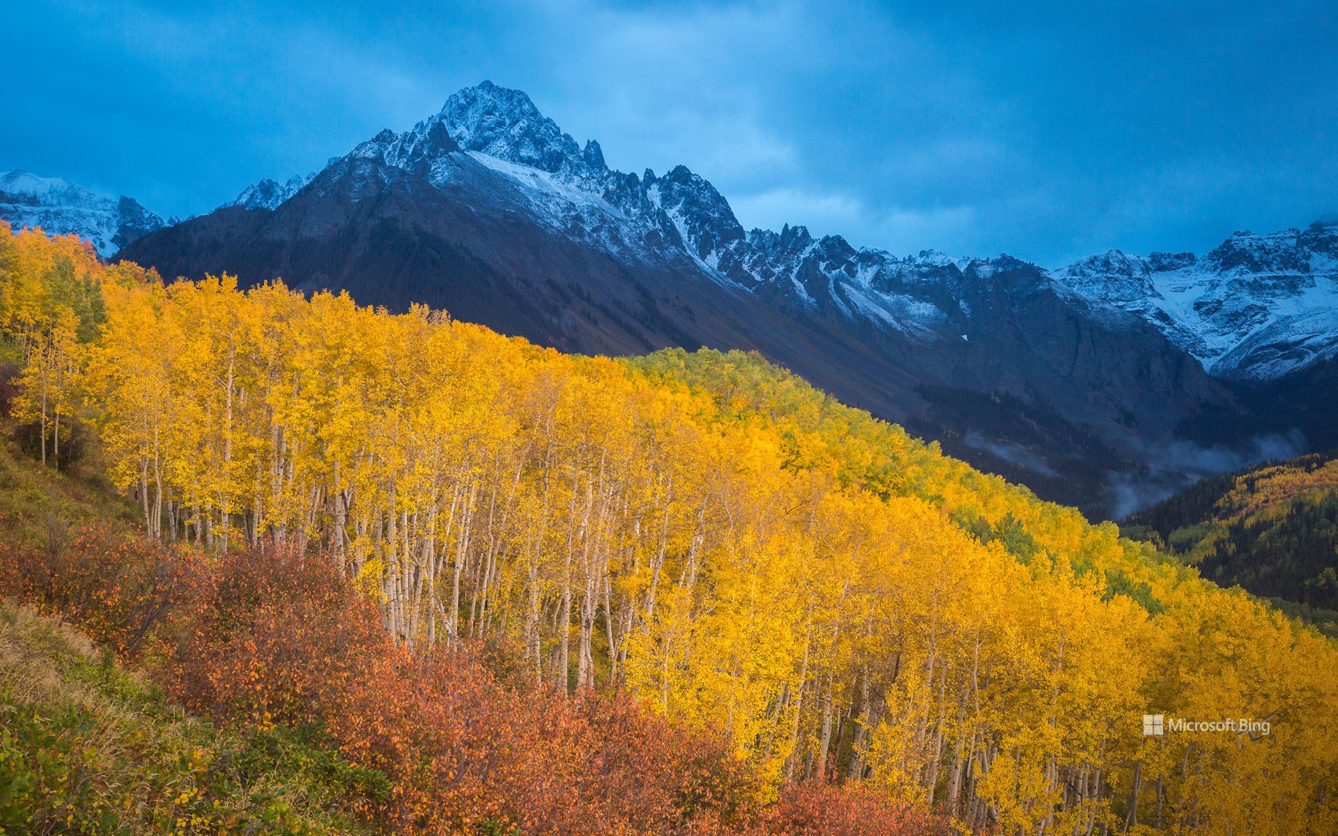
里奇韦附近斯内弗尔斯山脚下的秋色, 科罗拉多州, 美国 Fall colors below Mount Sneffels near Ridgway, Colorado (© Grant Ordelheide/TANDEM Stills + Motion)
金色的秋日余晖 Golden fall glow
斯内弗尔斯山脚下的秋色, 科罗拉多州, 美国
又到了一年之中,山峦褪去夏日青翠,披上绚烂秋色的时节。变色通常始于九月初至十月初,高处山坡率先染上秋意,随后低处山谷渐次跟进。白杨树堪称这场视觉盛宴的主角,其叶片在阳光下闪烁,宛如金币般熠熠生辉。然而白杨的绚烂并非年年如约而至。它们的色彩取决于多重因素——树木健康状况、局部气候变化、土壤湿度,以及生长海拔与纬度。健康的白杨林才是真正的季节主角:枝繁叶茂的林群色彩更明亮,落叶也更晚;而受压或衰弱的树木往往迅速褪色,只留下一抹短暂的辉煌。去年令人惊艳的景致,今年或许黯淡无光。今日镜头捕捉到斯内弗尔斯山麓的绚烂盛景——这座科罗拉多州斯内弗尔斯山脉的最高峰,从里奇韦镇拔地而起,海拔拔高逾7000英尺。
Fall colors below Mount Sneffels near Ridgway, Colorado
It's that time of year when the hills shed their summer greens, unveiling a blaze of colors that lights up the season. The change usually begins in September and early October, with higher slopes turning first, followed by the lower valleys. Among the stars of this display are the aspens, whose leaves shimmer like gold coins in the sunlight. The magic of aspen colors, however, isn't guaranteed year after year. Their golden glow depends on many factors—tree health, local weather shifts, soil moisture, and where they grow in terms of elevation and latitude. Healthy aspens are the true stars of the season: strong, thriving groves burst with brighter colors and hold onto their leaves longer, while stressed or weakened trees often fade quickly, offering only a glimpse of their usual brilliance. Today's image captures their full glow at the base of Mount Sneffels, the highest peak in Colorado's Sneffels Range, rising more than 7,000 feet above the town of Ridgway.
安顺桥中秋灯展,成都,中国 Anshun Bridge illuminated for the Mid-Autumn Festival, Chengdu, China (© Philippe LEJEANVRE/Getty Images)

安顺桥中秋灯展,成都,中国 Anshun Bridge illuminated for the Mid-Autumn Festival, Chengdu, China (© Philippe LEJEANVRE/Getty Images)
千里共婵娟 To the moon and back
安顺桥,成都,中国
当秋月当空,空气中已透出冬日的气息,那份战栗感总会在记忆中久久萦绕。中秋节——亦称月节——作为中国最珍视的节日之一,为丰收时节的尾声增添了又一抹神话色彩。它在农历八月十五日庆祝,今年恰逢10月6日。相传此夜,月神嫦娥正俯瞰人间。
家人团聚共享月饼——这种圆形糕点内馅或甜或咸,滋味美妙。与亲朋相聚欣赏灯笼、赏月,享受真挚的团圆时光。中秋时节的安顺桥被灯笼点亮,它沐浴在光芒中,为节日增添华彩。今夜,让我们举杯庆祝,一起享受这个美好的节日吧!祝愿大家,花好月圆,喜乐平安!
Anshun Bridge, Chengdu, China
The shiver felt under a full autumn moon, when the air hints at winter's arrival, has a way of lingering in memory. One of China's most cherished holidays, the Mid-Autumn Festival—also known as the Moon Festival—adds another touch of magic to the end of the harvest season. It's celebrated on the 15th day of the eighth lunar month of the Chinese calendar—this year, on October 6. According to legend, it's also the night when the moon goddess Chang'e watches over the world.
Families gather to share mooncakes—round pastries filled with sweet or savory goodness—and enjoy lanterns, moon gazing, and heartfelt reunions. One of the most enchanting sights is the Anshun Bridge in Chengdu, China—seen in today's image—glowing in golden light to honor the festival. Its arches reflect in the Jin River, creating a dreamy scene. In the United States, communities with Asian heritage celebrate with lantern parades, mooncake tastings, and cultural gatherings in cities like San Francisco, New York, and Dallas. Tonight, let the light guide you to the moon and back.
从SpaceX载人龙飞船“奋进号”视角看到的国际空间站主太阳能电池阵列 ISS main solar arrays seen from SpaceX Crew Dragon Endeavour (© NASA)

从SpaceX载人龙飞船“奋进号”视角看到的国际空间站主太阳能电池阵列 ISS main solar arrays seen from SpaceX Crew Dragon Endeavour (© NASA)
使命必达 Mission: Possible
世界空间周
10月4日至10日,世界空间周邀我们一同超越地球的界限,追逐星辰。这一盛事源于1957年苏联发射的"斯普特尼克1号"卫星,以及1967年签署的《外层空间条约》——这份开创性的国际承诺标志着人类和平探索宇宙的崭新篇章。在这一周里,教室里充满实验的热闹,天文馆里惊叹声不绝于耳,望远镜将人类与遥远星系相连。这些瞬间共同编织出科学探索的宇宙篇章,见证人类不断突破边界的执着追求。本年度主题明确:点燃新一代探索者、工程师和梦想家的热情,让他们准备好改写宇宙的篇章。
今天这张照片展示了国际空间站(ISS)的壮观景象,这座由16个国家共同建造的巨型实验室,正环绕地球约250英里的轨道运行。其太阳能电池板持续吸收阳光,为微重力环境研究、前沿科技探索以及人类在地球之外的生存实验提供动力。这张照片由SpaceX载人龙飞船“奋进号”拍摄——这艘可重复使用的航天器自2020年以来已完成六次任务,负责运送宇航员和货物。这一场景生动诠释了人类选择合作而非竞争时所能取得的成就。每一块闪闪发光的太阳能板都在昭示:最后的疆域触手可及,而探索它的无畏气魄,正是人类的本质。
World Space Week
From October 4 to 10, World Space Week invites us to transcend our earthly bounds and chase the stars. It was born from the launch of Sputnik 1 by the USSR in 1957 and the signing of the Outer Space Treaty in 1967, a pioneering international commitment to peaceful cosmic exploration. During this week, classrooms buzz with experiments, planetariums echo with wonder, and telescopes bridge the gap to distant galaxies. Together, these moments weave a universal story of science, discovery, and humanity's relentless drive to push boundaries. The week's mission is clear: to ignite the next generation of explorers, engineers, and dreamers ready to rewrite the cosmos.
Today's image captures the International Space Station, a vast laboratory built by 15 nations, orbiting about 260 miles above Earth. Its solar arrays soak up sunlight to power groundbreaking research on microgravity, technology, and human survival beyond our planet. Shot from the SpaceX Crew Dragon Endeavour—a reusable spacecraft that has completed six missions since 2020, ferrying astronauts and cargo—this scene embodies what humanity can achieve when it chooses cooperation over competition. Each gleaming panel makes it clear: the final frontier is within reach, and the audacity to explore it defines us.
布里特尔峡谷里生长的帚石楠花, 斯凯岛, 苏格兰 Heather growing in Glen Brittle, Isle of Skye, Scotland (© Adam Mowery/TANDEM Stills + Motion)
布里特尔峡谷里生长的帚石楠花, 斯凯岛, 苏格兰 Heather growing in Glen Brittle, Isle of Skye, Scotland (© Adam Mowery/TANDEM Stills + Motion)
雾中遐想 Mist-bound reveries
格伦·布里特尔,苏格兰斯凯岛
雾气袅袅,水波粼粼,传说萦绕——欢迎来到格伦·布里特尔。在苏格兰传说中的“雾岛”斯凯岛上,峡谷绵延展开,紫色石楠花如地毯般铺满崎岖山坡。这片土地回荡着历史的低语:远在八千年前新石器时代猎人循溪而行之前,恐龙的足迹早已镌刻于峭壁之上。九世纪时,航海的北欧维京人在此定居。数百年后,强大的麦克劳德与麦克唐纳氏族相继占据这片疆土,他们的城堡见证了无数战役与同盟的兴衰。
在群山与隐秘湖泊之间,仙女池闪烁着翡翠与绿松石般的光泽,水流在火山岩上翻滚奔涌——据当地传说,这里曾是仙女们在月光下翩跹起舞之地。不远处,被称为“水之釜”的科鲁伊斯克湖隐匿于锯齿状的黑色库林山峰之下,相传湖中有水怪出没,是一种能变幻形貌的水灵。红鹿在石楠丛中悄然滑行,野兔沿着隐秘小径消失不见,金雕在高空盘旋。布里特尔峡谷正是地质奇观、野生动物与人类历史交织之地。每块岩石、每道瀑布、每座山谷都在诉说故事——请轻步慢行,侧耳倾听。
Glen Brittle, Isle of Skye, Scotland
Mists curl, waters glimmer, and legends linger—welcome to Glen Brittle. On the Isle of Skye, Scotland's fabled 'Misty Isle,' the glen stretches in a sweep of purple heather carpeting its rugged slopes. The landscape hums with echoes of the past: dinosaurs left footprints on these cliffs long before Mesolithic hunters traced its streams over 8,000 years ago. In the 9th century, seafaring Norse Vikings settled here. Centuries later, the powerful MacLeod and MacDonald clans claimed these lands, their castles standing guard over countless battles and alliances.
Among the hills and hidden lochs, the Fairy Pools shimmer in emerald and turquoise, tumbling over volcanic rock—a place where, according to local tales, fairies once danced under the moonlight. Nearby, Loch Coruisk, the 'Cauldron of Waters,' tucked beneath the jagged Black Cuillin peaks, is said to be haunted by a kelpie, a shape-shifting water spirit. Red deer glide silently through the heather, rabbits vanish along secret trails, and golden eagles wheel above. Glen Brittle is where geology, wildlife, and human history intertwine. Every stone, waterfall, and valley tells a story—step softly and listen closely.
蛇河上的牛轭湖, 大提顿国家公园, 怀俄明州, 美国 Oxbow Bend on the Snake River, Grand Teton National Park, Wyoming (© DanitaDelimont.com/AWL Images/SuperStock)
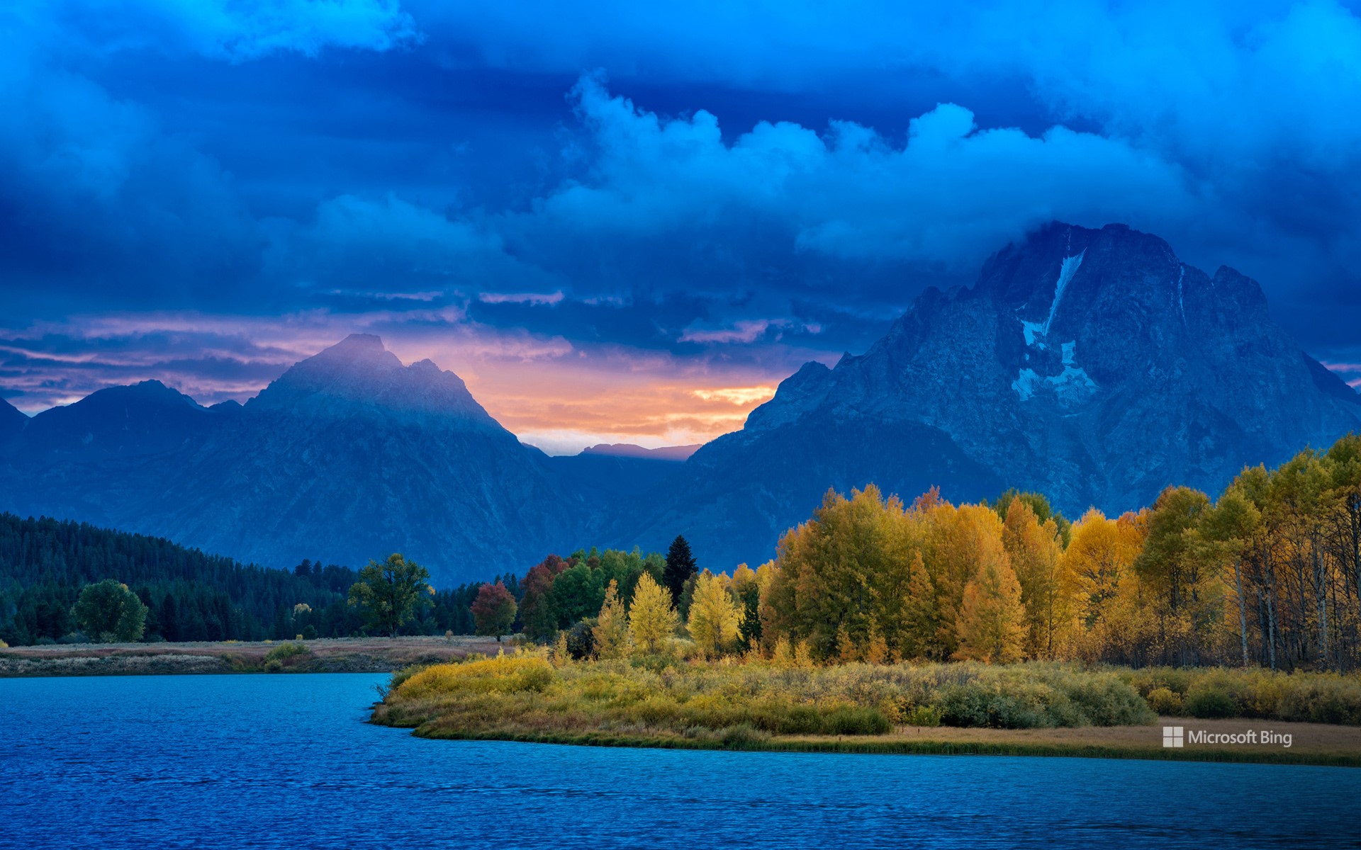
蛇河上的牛轭湖, 大提顿国家公园, 怀俄明州, 美国 Oxbow Bend on the Snake River, Grand Teton National Park, Wyoming (© DanitaDelimont.com/AWL Images/SuperStock)
法定自然区 Wild by law
蛇河上的牛轭湖, 大提顿国家公园, 怀俄明州
除了水,河流还承载着生命、历史和故事。它们是大自然对我们景观的永恒贡献,流淌过大地,跨越时间。蜿蜒流经怀俄明州大提顿国家公园的蛇河便是其中一颗瑰宝。这条河上一个尤为令人惊叹的景点是牛轭湖湾——今天这张照片中就出现了——平静的水面倒映着巍峨的提顿山脉,驼鹿和白头鹰等野生动物在这里繁衍生息。在这里,河水自由流淌,不受混凝土或商业的束缚,受到1968年今天签署的《野生与风景河流法案》的保护。
这项具有里程碑意义的法律是一项承诺:有些河流将永远奔腾不息。它守护着那些拥有“非凡之美”的水域,守护着生态和精神——歌唱着荒野,低语着遗产的河流。蛇河源头,包括牛轭湾,于2009年被列入这份神圣名单,确保其倒影不受干扰,韵律不被打破。
黎明时分,薄雾在河湾处舞动,群山沐浴在晨曦的余晖中。游客驻足,静静地欣赏着大自然的诗意。多亏了这项法案,这条河的故事得以流淌——未受驯服,未受污染,令人难忘。
Oxbow Bend on the Snake River, Grand Teton National Park, Wyoming
Beyond water, rivers carry life, history, and stories. They are nature's ever-moving contribution to our landscapes, flowing through lands and across time. One such gem is the Snake River, which winds through Grand Teton National Park in Wyoming. A particularly stunning spot along this river is Oxbow Bend—featured in today's image—where calm waters reflect the towering Teton Range, and wildlife such as moose and bald eagles thrive. Here, water flows freely, unbound by concrete or commerce, protected by the Wild and Scenic Rivers Act, signed on this day in 1968.
This landmark law is a promise: that some rivers shall run wild forever. It safeguards waters with 'outstandingly remarkable' beauty, ecology, and spirit—rivers that sing of wilderness and whisper of heritage. The Snake River Headwaters, including Oxbow Bend, joined this sacred list in 2009, ensuring its reflections remain undisturbed and its rhythms unbroken.
At dawn, mist dances over the bend, and the mountains blush with the first light. Visitors pause, hushed by nature's poetry. Thanks to this Act, the river's story flows on—untamed, unspoiled, unforgettable.
克拉克山脉, 内华达山脉, 约塞米蒂国家公园, 加利福尼亚州, 美国 Clark Range, Sierra Nevada, Yosemite National Park, California (© Robb Hirsch/TANDEM Stills + Motion)
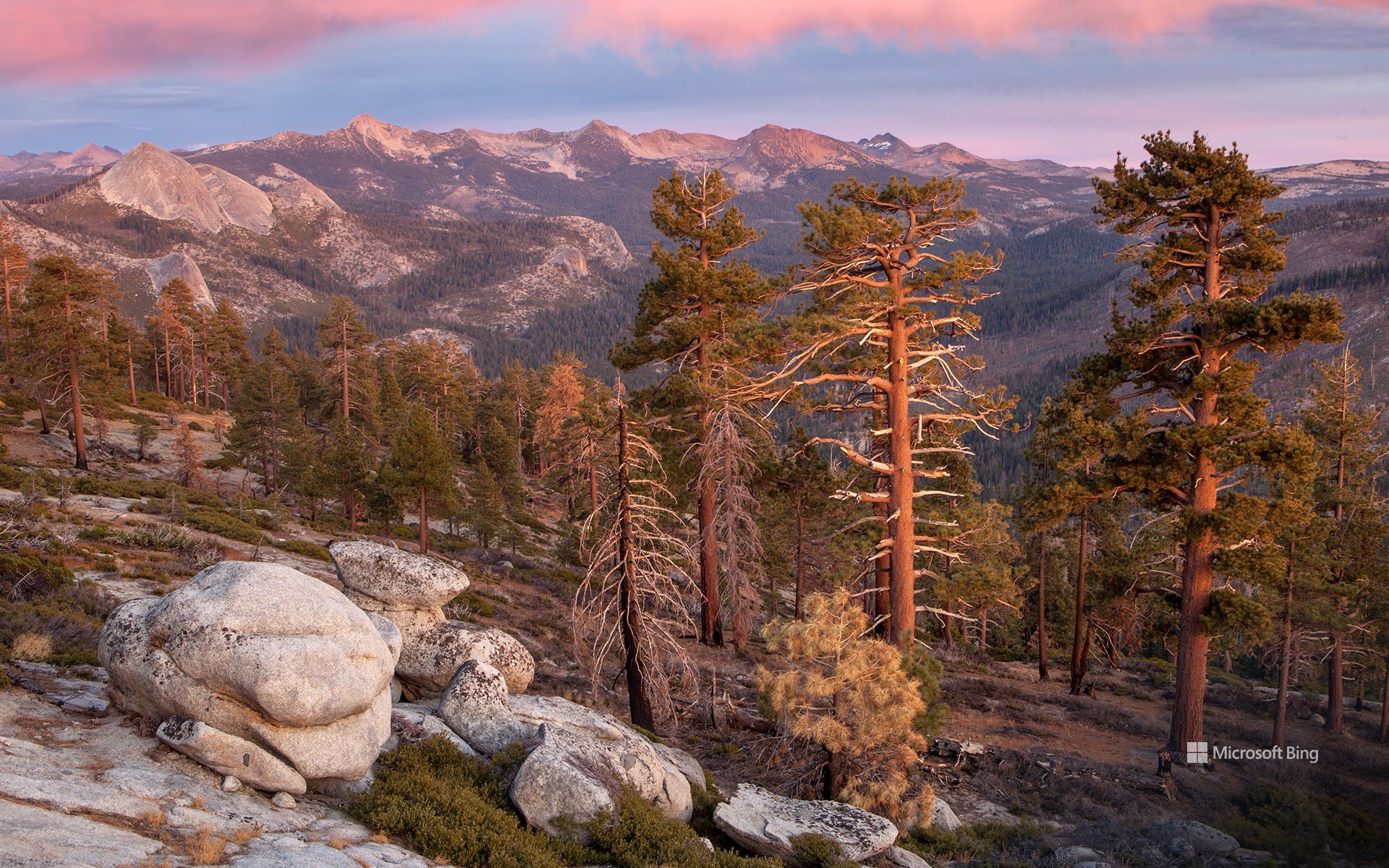
克拉克山脉, 内华达山脉, 约塞米蒂国家公园, 加利福尼亚州, 美国 Clark Range, Sierra Nevada, Yosemite National Park, California (© Robb Hirsch/TANDEM Stills + Motion)
克拉克山脉的回声 Echoes from the Clark Range
克拉克山脉, 约塞米蒂国家公园, 加利福尼亚州
今年是约塞米蒂国家公园遗产的又一个里程碑。约塞米蒂国家公园自1864年以来一直受到保护,以其令人惊叹的壮丽景色和生态意义而闻名。约塞米蒂坐落在内华达山脉的中心地带,占地近1200平方英里,孕育着巨大的花岗岩、奔腾的瀑布和古老的红杉。克拉克山脉是其鲜为人知的瑰宝之一——今天照片中显示的崎岖高海拔山脊。它以约塞米蒂的第一位守护者、自然保护先驱盖伦·克拉克的名字命名。
克拉克山脉静静地守护着约塞米蒂南部的荒野,其山峰被冰川侵蚀,顶部覆盖着高山草甸。这里,微风轻拂白皮松,天空开阔,呼应着公园诞生时的远见卓识。
Clark Range, Yosemite National Park, California
This year marks another milestone in the legacy of Yosemite National Park, a sanctuary protected since 1864 and celebrated for its awe-inspiring grandeur and ecological significance. Nestled in the heart of the Sierra Nevada, Yosemite's nearly 1,200 square miles cradle granite giants, cascading waterfalls, and ancient sequoias. Among its lesser-known treasures lies the Clark Range—the rugged, high-elevation spine seen in today's image. It was named after Galen Clark, Yosemite's first guardian and a pioneer of conservation.
The Clark Range stands as a quiet sentinel to Yosemite's southern wilderness, its peaks etched by glaciers and crowned with alpine meadows. Here, the wind whispers through whitebark pines and the sky opens wide, echoing the spirit of foresight that birthed the park.
As we honor Yosemite's anniversary, we celebrate not only its grandeur but the enduring vision of those who fought to preserve it. From the valley's granite walls to the Clark Range's serene heights, this national park remains a living poem—written in stone, water, and time.
豪滕镇的彩虹屋, 荷兰 The Rainbow Houses of Houten, Netherlands (© George Pachantouris/Getty Images)
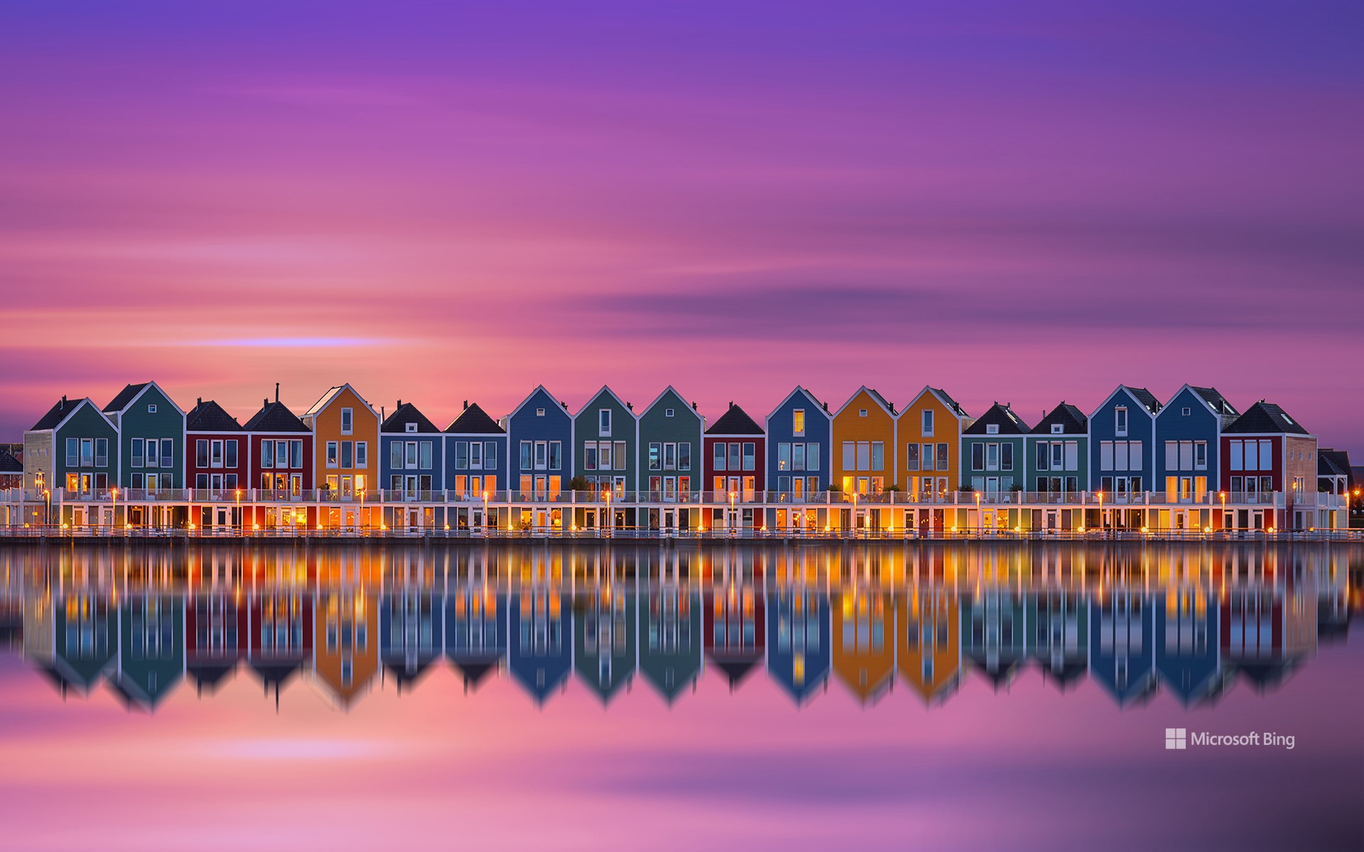
豪滕镇的彩虹屋, 荷兰 The Rainbow Houses of Houten, Netherlands (© George Pachantouris/Getty Images)
彩虹骑行与宁静氛围 Rainbow rides and quiet vibes
彩虹屋,荷兰豪滕
你不会找到纪念品商店或旅游地图指引方向——但沿着豪滕的里特普拉斯湖畔,你会偶然发现荷兰最令人意想不到的上镜景点之一。虽然许多人涌向阿姆斯特丹的运河或鹿特丹的方块屋,但这座宁静的通勤小镇却拥有独特的建筑风格。彩虹屋如海市蜃楼般鳞次栉比,闪耀着大胆的绘画色彩——一个住宅区变成了一个低调的文化地标。
对当地人来说,它们只是日常生活的一部分。但对于摄影师和设计爱好者来说,它们是色彩饱和、对称的梦幻景观。该建筑群由汉斯·比恩 (Hans Been) 设计,于 2005 年竣工,将加勒比海风情与北欧的内敛风格融为一体,呼应了简约渔村的面貌。每栋房子都反射出不同的色彩。这不是一个精心策划的旅游景点;这些都是有人居住的住宅,它们所在的社区也经过了同样周到的规划,而豪滕正是凭借这种规划成为全国最适合骑自行车的城镇之一。从湖对岸或附近的桥上欣赏这些色彩鲜艳的建筑外观最为理想,它们就像一个秘密,只有在合适的光线下才能幸运地捕捉到:迷人、惊喜,而且低调得令人耳目一新。
The Rainbow Houses of Houten, Netherlands
You won't find souvenir shops or tourist maps pointing the way—but follow the edge of Lake Rietplas in Houten, and you'll stumble upon one of the Netherlands' most unexpectedly photogenic sights. While many flock to Amsterdam's canals or Rotterdam's cube houses, this quiet commuter town offers its own architectural twist. Lined up like a mirage, the Rainbow Houses shimmer in bold, painterly hues—a residential block turned an understated cultural landmark.
To locals, they're simply part of the daily backdrop. But for photographers and design lovers, they're a dreamscape of saturation and symmetry. Designed by Hans Been and completed in 2005, the ensemble blends Caribbean flair with Nordic restraint, echoing the look of a minimalist fishing village. Each house reflects a different color of the spectrum. This isn't a curated tourist stop; these are lived-in homes, part of a neighborhood shaped by the same thoughtful planning that makes Houten one of the most bike-friendly towns in the country. Best seen from across the lake or a nearby bridge, these vibrant facades feel like a secret you're lucky to catch in the right light: charming, surprising, and refreshingly under the radar.
托斯卡纳的皮恩扎镇, 意大利 Town of Pienza in Tuscany, Italy (© zpagistock/Getty Images)
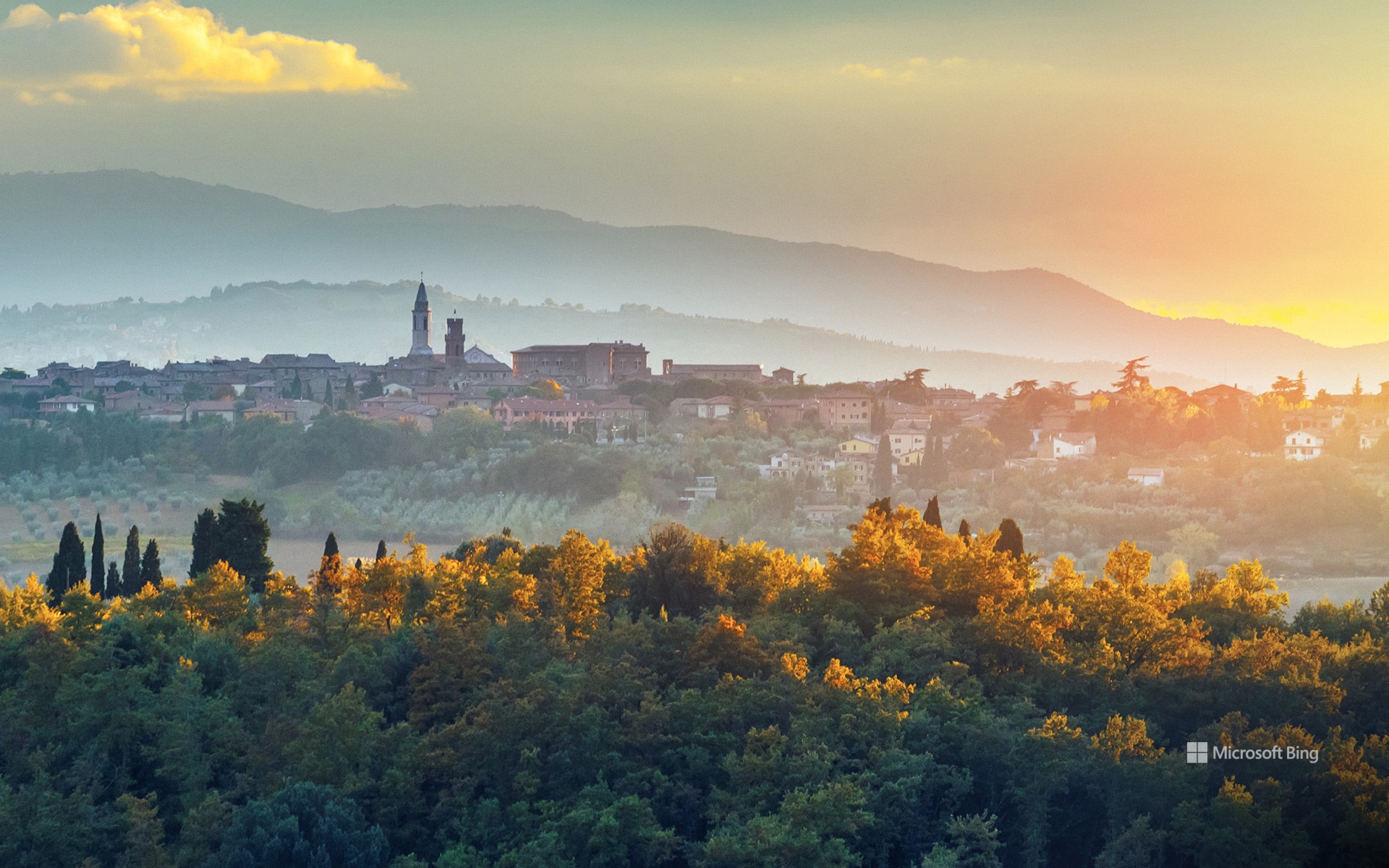
托斯卡纳的皮恩扎镇, 意大利 Town of Pienza in Tuscany, Italy (© zpagistock/Getty Images)
品味皮恩扎 A taste of Pienza
托斯卡纳的皮恩扎镇, 意大利
有些城镇历经数个世纪缓慢演变。皮恩扎?15世纪,一位教皇为了证明某种观点——或许也为了炫耀——彻底重塑了它。这座意大利小镇坐落在奥尔恰山谷之上,周围环绕着连绵起伏的群山,其景象与你想象中的托斯卡纳一模一样:柏树成荫,蜿蜒的土路,偶尔还能看到几只绵羊。它宁静祥和。而当你踏入城墙,它便会变得灵动起来。
皮恩扎曾是一个普通的中世纪村庄,名叫科尔西尼亚诺。直到教皇庇护二世的儿子决定改造他的家乡,他聘请了建筑师贝尔纳多·罗塞利诺,按照文艺复兴时期的对称、秩序与和谐理念重建了这片区域。结果如何?这片区域仿佛是经过精心设计的。中心广场皮奥二世广场两侧分别矗立着大教堂、教皇宫殿和市政厅,布局也恰到好处。此外,皮恩扎还以佩科里诺奶酪而闻名——这是一种以羊奶为原料,以独特的方式陈酿而成的奶酪。每年一次,整个小镇都会变成奶酪竞技场,举办“奶酪节”(Fiera del Cacio),这是一个以“奶酪轮”(Cacio al Fuso)为特色的节日——这是一种人们将奶酪轮滚向目标的游戏。
The town of Pienza in Tuscany, Italy
Some towns evolve slowly over centuries. Pienza? It received a full rebrand in the 1400s from a pope who wanted to prove a point—and maybe show off a little. This tiny Italian town is perched above the Val d'Orcia, surrounded by rolling hills that look exactly like you think Tuscany should: cypress trees, winding dirt roads, the occasional sheep. It's peaceful. And then you step inside the town walls, and it gets clever.
Pienza was once a regular medieval village called Corsignano. That is, until one of its sons became Pope Pius II and decided to transform his hometown. He hired architect Bernardo Rossellino and rebuilt the area based on Renaissance ideals of symmetry, order, and harmony. The result? A site that feels intentional. The central square, Piazza Pio II, is flanked by a cathedral, a papal palace, and a town hall, all arranged just so. Moreover, Pienza is known for pecorino cheese—sheep's milk, aged in interesting ways. And once a year, the whole town turns into a cheese arena for Fiera del Cacio, a festival featuring Cacio al Fuso—a game where people roll wheels of cheese at a target.
坦克湖 (Tank Lakes), 高山湖泊荒野区, 华盛顿州, 美国 Tank Lakes, Alpine Lakes Wilderness, Washington (© Austin Trigg/TANDEM Stills + Motion)
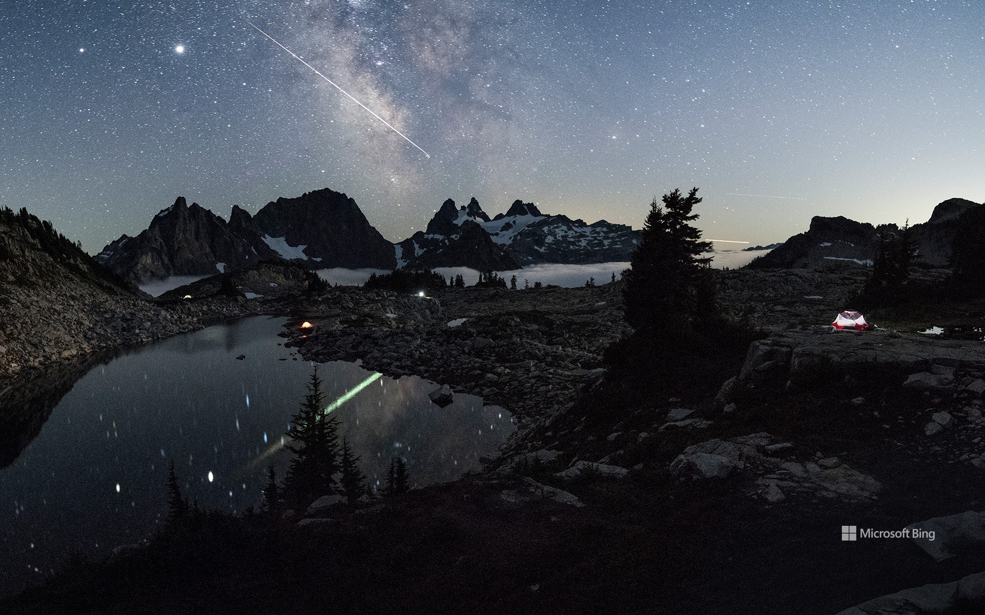
坦克湖 (Tank Lakes), 高山湖泊荒野区, 华盛顿州, 美国 Tank Lakes, Alpine Lakes Wilderness, Washington (© Austin Trigg/TANDEM Stills + Motion)
美丽的星空 Weeding and wishing
坦克湖, 高山湖泊荒野区, 华盛顿
今天图片中璀璨的星空来自于坦克湖,它位于高山湖泊荒野区。高山湖泊荒野占地超过40万英亩,位于风景如画的华盛顿州中部喀斯喀特山脉。荒野位于喀斯喀特山脉北段的斯诺夸米山口和史蒂文斯山口之间,其中包括被称为韦纳奇山脉的子山脉,该山脉构成了韦纳奇-雅基马分水岭。
这片荒野由冰川侵蚀而成,点缀着700多个湖泊。许多山峰和山坡终年被雪原覆盖。从生长着花旗松、雪松的湿润森林,到生长着沙拉树和浆果的林下层,这片地貌逐渐延伸至低矮植物覆盖的广阔草甸,最终以生长着黄松的干燥林地结束。
Astronomy Day and National Public Lands Day
When the calendar lines up just right, you get a rare double feature: National Public Lands Day and Astronomy Day. It's a chance to explore the landscapes that ground us and the skies that inspire us—all within 24 hours.
National Public Lands Day, held on the fourth Saturday of September, is America's biggest single-day volunteer event for parks, forests, and other shared spaces. Volunteers rake, plant, and pick up litter—all while enjoying free admission to these sites. Astronomy Day comes twice a year, with the fall version offering longer nights and darker skies. The goal is simple: help more people discover the universe. Many parks are far from city lights, making them prime spots for seeing the Milky Way, meteor showers, and constellations without interference. Remote places like Tank Lakes in Washington's Alpine Lakes Wilderness, pictured here, offer exactly that.
This year, why not make it a two-for-one celebration? Hike a trail by day, then trace constellations by night. On National Public Lands Day, you might cross paths with a deer or eagle. On Astronomy Day, your companions could be Orion or Cassiopeia. Different worlds, same sense of wonder.