干草捆,北约克郡,英格兰 Hay bales, North Yorkshire, England (© Nick Brundle Photography/Getty Images)
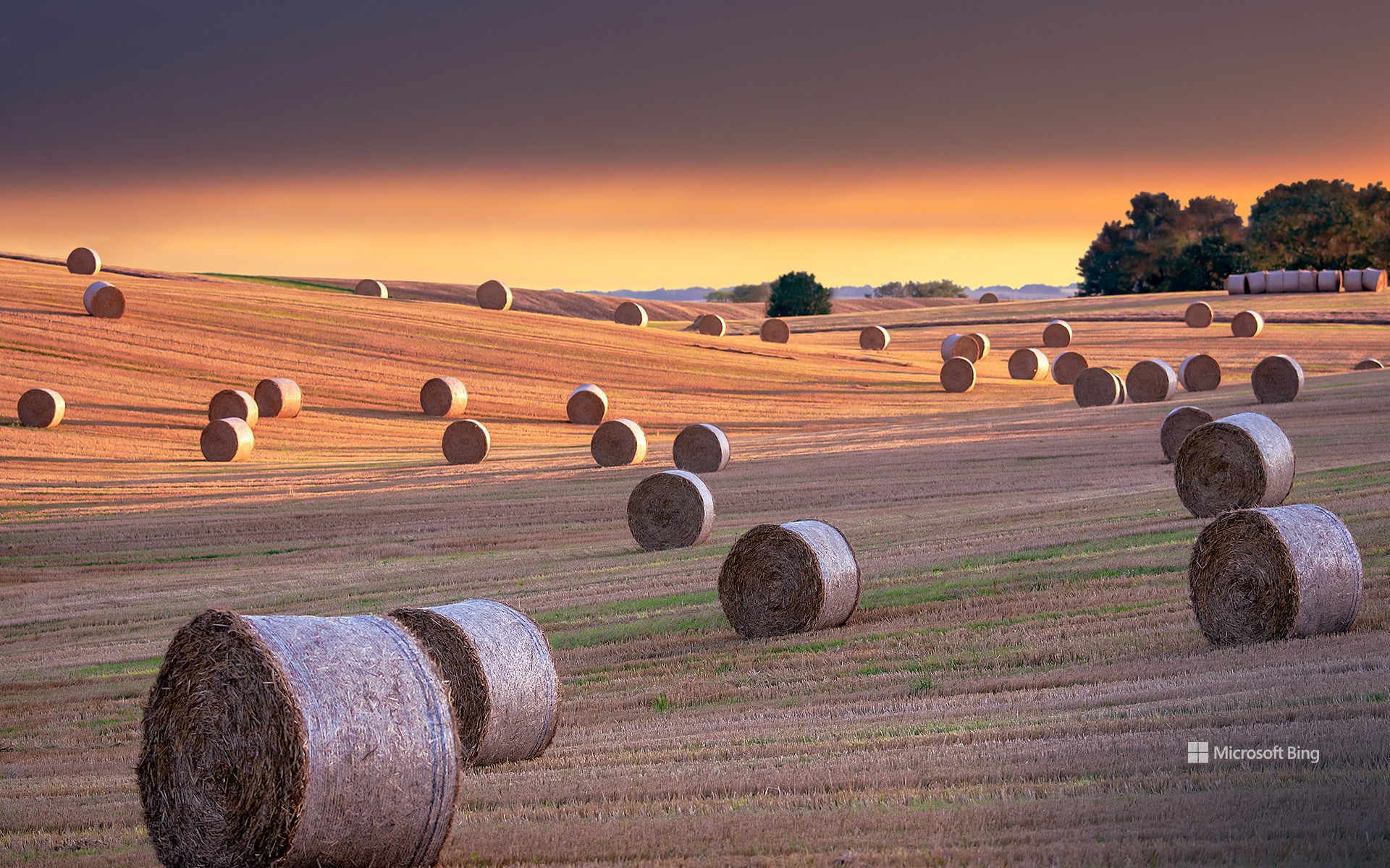
干草捆,北约克郡,英格兰 Hay bales, North Yorkshire, England (© Nick Brundle Photography/Getty Images)
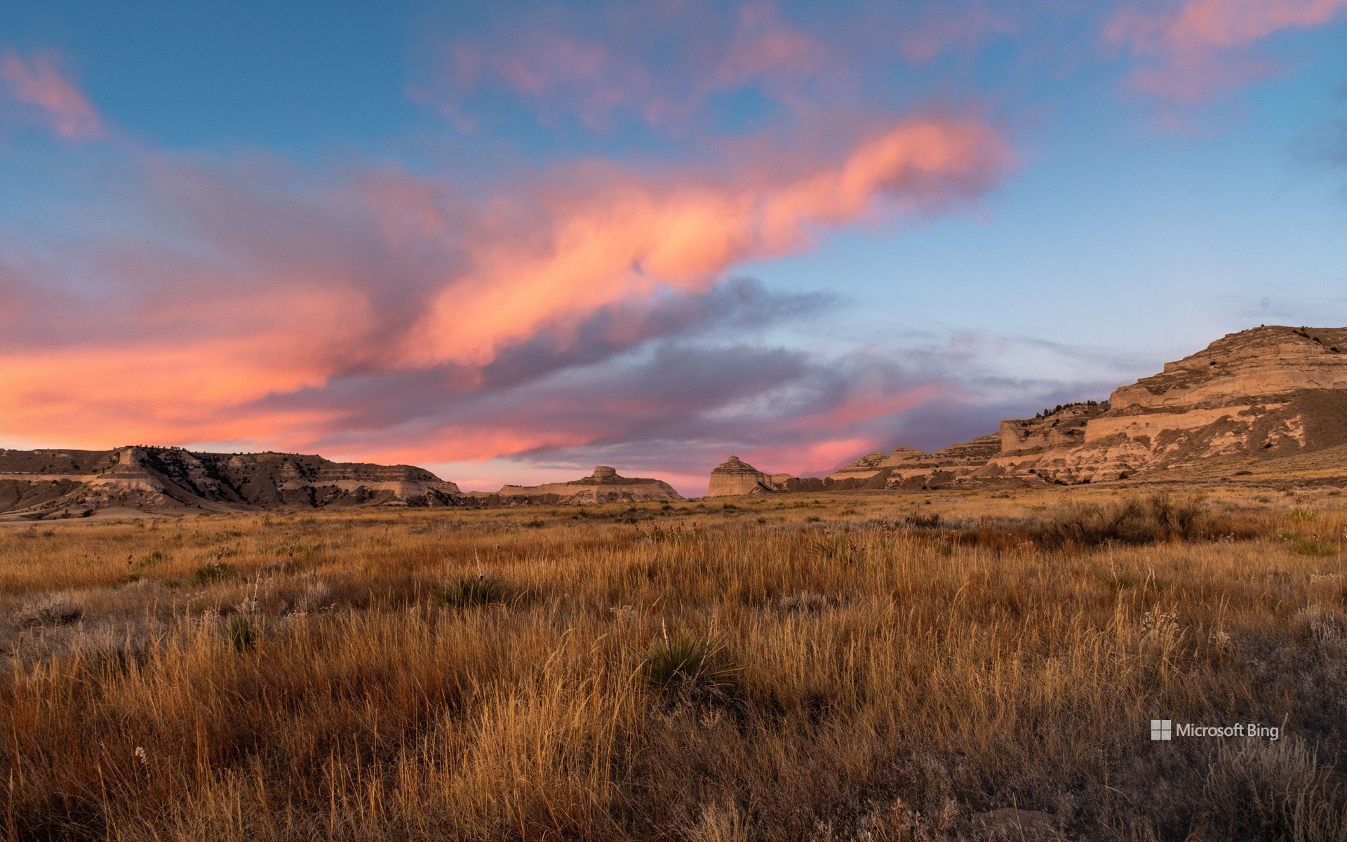
阳光明媚,赶紧打草 'Hay' there!
北约克郡的干草捆,英格兰
“趁着阳光明媚,赶紧打草”这句谚语听起来可能有些陈旧,但在农业领域,它却是实实在在的真理。打草捆在全球农业中扮演着至关重要的角色。这一过程包括割草、晾干和包装草料,以便在寒冷季节喂养牲畜。整个流程高度依赖天气条件:草料必须在打捆前完全干燥,否则容易发霉。农民必须在干旱天气来临时迅速行动,因此这成为了一场季节性的赛跑。
干草打捆技术可追溯至数个世纪前,从19世纪的马力打捆机演变为如今能在数分钟内完成打捆、包裹和排出草捆的高功率机械。在英国北约克郡(今日照片拍摄地),起伏的低地与高地草甸为种植和晾晒优质干草提供了理想条件。由于放牧牲畜(如羊和牛)占农场总数的约40%,干草已成为支撑该地区农村经济的关键饲料资源。因此,当你看到金黄色的田野上点缀着整齐的、沐浴在阳光下的干草卷时,你正在见证精心规划与辛勤劳动的成果。这一传统至今仍与往昔一样重要。
Hay bales in North Yorkshire, England
'Make hay while the sun shines' may sound like an old proverb, but in farming it's a practical truth. Hay baling plays a crucial role in agriculture worldwide. It involves cutting, drying, and packaging grasses to feed livestock during the colder months. The process depends heavily on the weather: the grass must be dry before it's baled, or it risks molding. Farmers must act quickly once a dry spell arrives, making it a seasonal race.
The practice of baling dates back centuries, evolving from horse-powered balers of the 1800s to today's high-powered machines that can wrap and eject bales in minutes. In North Yorkshire, England—where today's image was taken—the rolling lowlands and upland meadows create ideal conditions for growing and curing high-quality hay. With grazing livestock such as sheep and cattle making up around 40% of farm holdings, hay is a key feed resource supporting the region's rural economy. So, when you see golden fields dotted with neat, sunlit rolls, you're witnessing the result of careful timing and hard work. It's a tradition that remains as important today as ever.
位于莫特拉瓦河河畔的格但斯克市,波兰 Gdańsk on the banks of the Motława, Poland (© Oscar Dominguez/TANDEM Stills + Motion)
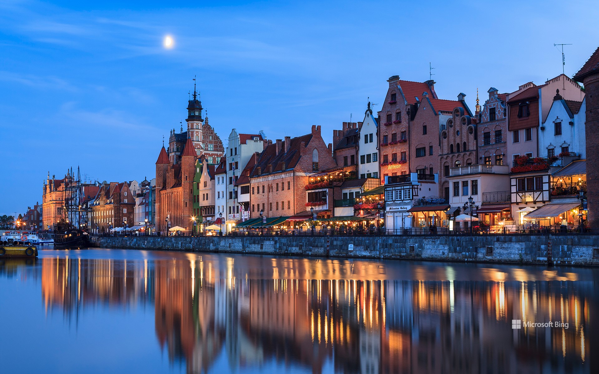
位于莫特拉瓦河河畔的格但斯克市,波兰 Gdańsk on the banks of the Motława, Poland (© Oscar Dominguez/TANDEM Stills + Motion)
淡彩的梦境和静水 Pastel dreams and still waters
莫特拉瓦河河畔的格但斯克市,波兰
格但斯克是波兰滨海省一座充满活力的城市,鹅卵石铺就的魅力与清凉的海岸交相辉映。它是格但斯克湾沿岸的三联城(Tricity)的一部分,该区域包括邻近的沿海城市索波特和格丁尼亚市以及周边城镇。这座城市的名字很可能源于“Gdania”,这是流经该市的莫特拉瓦河(Motława)的早期名称。
这座城市起源于10世纪后期的一座斯拉夫人堡垒,最早的记载出现于997年,当时它受到了波兰国家的早期影响。几个世纪以来,格但斯克经历了波兰、德国和独立统治,每个时期都在该地区的特征上留下了印记。主城区吸引着大多数游客,尤其是沿着Ulica Długa(长街)和Długi Targ(长市场)的热闹长廊。这条步行街两侧是装饰华丽的大门,两旁排列着以17 世纪风格重建的庄严联排别墅,充满魅力。它曾是波兰皇室的礼仪之路,现在被亲切地称为皇家之路。这条道路像一座活生生的博物馆一样展开,点缀着高地门、琥珀博物馆、乌法根之家、主市政厅、海王星喷泉和宏伟的阿特斯法院等历史地标。
Gdańsk on the banks of the Motława, Poland
Where cobbled charm meets coastal cool, Gdańsk is a dynamic city in Poland's Pomorskie province. It is part of Tricity—a metropolitan area along the Gdańsk Bay that includes the neighboring coastal cities of Sopot and Gdynia, along with nearby towns. The city likely takes its name from 'Gdania,' an earlier name for the Motława river that runs through it.
The city originated as a Slavic fort in the late 10th century and was first recorded in 997, when it came under the early influence of the Polish state. Over the centuries, Gdańsk has experienced Polish, German, and independent rule, each leaving a mark on the region's identity. The Main City draws most visitors, especially to the lively promenade that runs along Ulica Długa (Long Street) and Długi Targ (Long Market). Flanked by decorative gates and lined with stately townhouses rebuilt in 17th-century style, this pedestrian stretch is steeped in charm. Once the ceremonial path for Polish royalty, it's now fondly known as the Royal Route. The path unfolds like a living museum, dotted with historic landmarks like the Highland Gate, Amber Museum, Uphagen's House, Main Town Hall, Neptune's Fountain, and the grand Artus Court.
太平洋公园,圣莫妮卡州立海滩,加利福尼亚州,美国 Pacific Park at Santa Monica State Beach, California (© EXTREME-PHOTOGRAPHER/Getty Images)
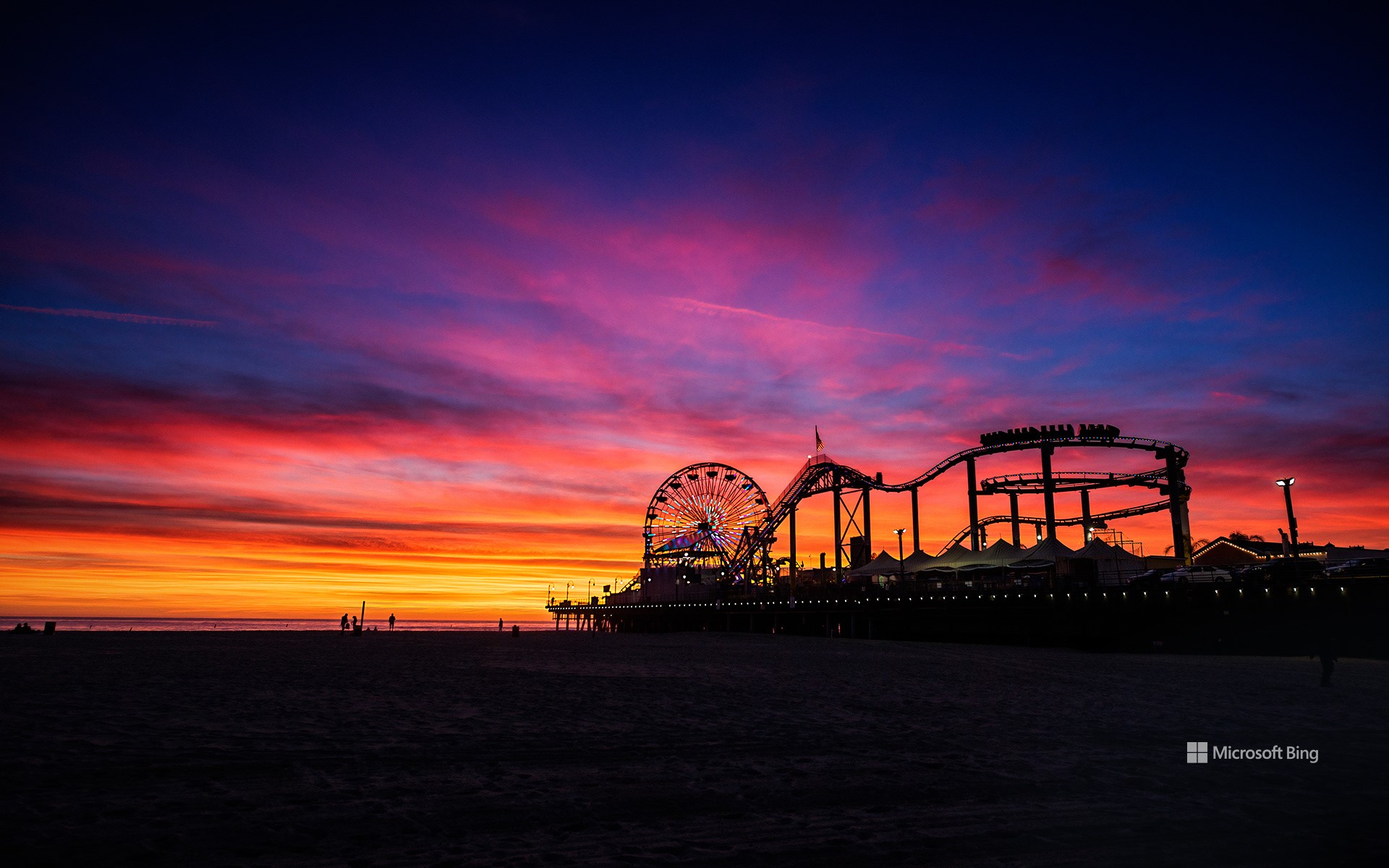
太平洋公园,圣莫妮卡州立海滩,加利福尼亚州,美国 Pacific Park at Santa Monica State Beach, California (© EXTREME-PHOTOGRAPHER/Getty Images)
完美的夜晚 A pier-fect evening
太平洋公园,圣莫尼卡州立海滩,加利福尼亚州
当夕阳西下,洒下橙色、粉色和紫色的光芒时,圣莫尼卡从悠闲的氛围中转为灯火通明。真的!这片海滩拥有超过3英里的沙滩、一座历史悠久的码头,以及风景如画的太平洋海岸公路,不仅仅是一条美丽的海岸线。让我们先从沙滩说起。宽阔、洁净,无论是打排球还是悠闲地读一本好书,这里都是日光浴爱好者和沙堡建造者的理想之地。
然后是圣莫尼卡码头。它建于1909年,至今仍屹立于木桩之上,拥有一个名为太平洋公园的游乐园、游乐场、餐厅,以及著名的太阳能摩天轮。想体验更多运动?马文·布劳德自行车道(Marvin Braude Bike Trail),又名斯特兰德(Strand),是一条22英里长的自行车道,蜿蜒穿过海滩。租一辆自行车,骑过滑旱冰者、遛狗者,以及一边吃冰淇淋一边自拍的游客。这里的冲浪也是一大亮点。初学者可以在这里体验人生中的第一波浪潮,而专业人士则时刻关注着更远处的海浪。
Pacific Park, Santa Monica State Beach, California
When the sun clocks out in streaks of orange, pink, and purple, Santa Monica goes from laid-back to lit up. Literally. With over 3 miles of sand, a historic pier, and the Pacific Coast Highway keeping things scenic, this beach is more than just a pretty shoreline. Let's start with the sand. Wide, clean, and ready for volleyball or just flopping down with a good book, it's ideal for sunbathers and sandcastle architects alike. And yes, 'Baywatch' was filmed along Santa Monica Bay. Feel free to run in slow motion.
Then there's the Santa Monica Pier. Built in 1909 and still standing tall on wooden legs, it's got an amusement park called Pacific Park, arcade, restaurants, and that famous solar-powered Ferris wheel. Up for more movement? The Marvin Braude Bike Trail, or the Strand, is a 22-mile bike path that zips right through the beach. Rent a cruiser and ride past rollerbladers, dog walkers, and tourists trying to juggle ice cream and selfies. Here, the surf is another draw. Beginners can catch their first wave here, while pros keep an eye on the swells farther out.
边界水域独木舟区荒野区, 明尼苏达州, 美国 Boundary Waters Canoe Area Wilderness, Minnesota (© s.tomas/Shutterstock)

边界水域独木舟区荒野区, 明尼苏达州, 美国 Boundary Waters Canoe Area Wilderness, Minnesota (© s.tomas/Shutterstock)
享受宁静 'Embrace Serenity
独木舟区荒野, 明尼苏达州, 美国
这里是位于明尼苏达州东北部的边界水域独木舟荒野区。该区域跨越超过100万英亩,由相互连接的湖泊、河流和针叶林组成。这里的地貌由冰川雕琢的水道、岩石露头和茂密林地交织而成,为驼鹿、狼、鸥鸟及无数其他物种提供了理想栖息地。该地区拥有超过1200英里的皮划艇航线和2000多个露营地,为人们提供了难得的与自然亲密接触、享受宁静的机会。
Annivesary of the Wilderness Act of 1964
The Wilderness Act of 1964, passed 61 years ago today, established the legal definition of wilderness in the United States. Its purpose was to preserve areas 'where the earth and its community of life are untrammeled by man.' This landmark legislation created the National Wilderness Preservation System, protecting millions of acres from development, roads, and mechanized use.
Among the most iconic areas protected under this act is the Boundary Waters Canoe Area Wilderness in northeastern Minnesota. Spanning over one million acres, it is a vast expanse of interconnected lakes, rivers, and boreal forests. The landscape is a mosaic of glacially carved waterways, rocky outcrops, and dense woodlands, offering a haven for moose, wolves, loons, and countless other species. With over 1,200 miles of canoe routes and more than 2,000 campsites, it provides a rare opportunity for solitude and immersion in nature. The Wilderness Act laid the foundation for safeguarding places like the Boundary Waters, ensuring they remain wild and untouched for future generations to experience and cherish.
凯撒施图尔,巴登-符腾堡,德国 Kaiserstuhl, Baden-Württemberg, Germany (© EyeEM Mobile GmbH/Getty Images)
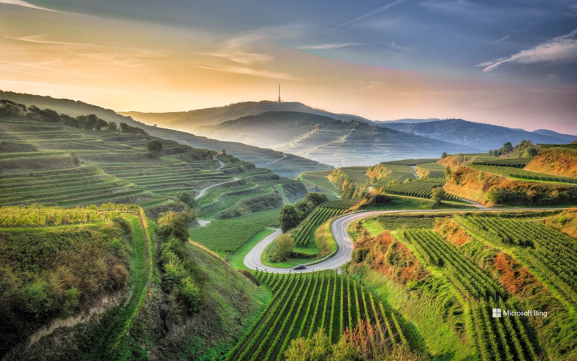
凯撒施图尔,巴登-符腾堡,德国 Kaiserstuhl, Baden-Württemberg, Germany (© EyeEM Mobile GmbH/Getty Images)
风景如画的葡萄园 Picturesque vineyards
凯撒施图尔,德国
凯撒施图尔山是巴登-符腾堡州南部一座低矮的小山脉,靠近弗莱堡,是德国阳光最充沛的地区之一。凯泽斯图尔因奥托三世皇帝于994年在此统治而得名。这片风景如画的地区是自然爱好者、寻求放松身心人士以及葡萄酒鉴赏家的天堂。肥沃的土壤和温和的气候,使灰皮诺和黑皮诺等葡萄品种在这里茁壮成长。过去的火山活动留下了富含矿物质的土壤,赋予了该地区葡萄酒独特的风味。连绵起伏的丘陵、田园诗般的村庄以及包括珍稀绿蜥蜴在内的多种野生动物,使凯泽斯图尔成为自然爱好者的迷人目的地。
路标清晰的徒步和自行车道穿过葡萄园、森林以及福格茨堡和恩丁根等历史名镇,这些小镇以其半木结构的房屋和巴登人的热情好客而令人着迷。春天,兰花盛开,秋天,充满情调的葡萄酒节令人心驰神往。您可以欣赏无尽的葡萄园梯田全景,感受巴登人的热情好客。
杰灵的斯科茨布拉夫国家纪念碑, 内布拉斯加州,美国 Scotts Bluff National Monument in Gering, Nebraska (© Hawk Buckman/Getty Images)
杰灵的斯科茨布拉夫国家纪念碑, 内布拉斯加州,美国 Scotts Bluff National Monument in Gering, Nebraska (© Hawk Buckman/Getty Images)
彩绘的云,静默的悬崖 Painted clouds, still cliffs
斯科茨布拉夫国家纪念碑, 内布拉斯加州
在GPS问世之前,像斯科茨布卢夫(Scotts Bluff)这样的自然地标就已高耸于大草原之上,为西行的旅人指明方向。在1887年杰林镇(Gering)建镇之前,以及内布拉斯加州于1867年成为美国州份的数十年之前,这些砂岩和泥岩地貌已然引导着成千上万的旅人沿着俄勒冈小径、加利福尼亚小径和摩门教徒小径前行。斯科茨布卢夫国家纪念碑(Scotts Bluff National Monument)以皮毛商人希拉姆·斯科特(Hiram Scott)命名,他曾是落基山皮毛公司(Rocky Mountain Fur Company)的成员,于19世纪20年代在附近地区因神秘原因去世。
如今,这座占地近3000英亩的纪念碑包括两座主要悬崖——北部的斯科茨悬崖和南部的南悬崖。它还保护着五处显著的岩石突起:圆顶岩、鹰岩、皇冠岩、马鞍岩和哨兵岩。在地面上,骡鹿与黑尾草原犬鼠一同觅食,而豺狼在周围游荡,短草在风中摇曳。更高处,景观发生变化,刺叶丝兰和耐寒灌木依附于岩石斜坡,而大角羊则轻松地在悬崖间穿行。尽管马车早已消失,斯科茨悬崖仍作为历史与地形的向导屹立不倒。
Scotts Bluff National Monument, Gering, Nebraska
Long before GPS, natural landmarks like Scotts Bluff rose high above the prairie, signaling to travelers that they were on the right path heading west. Before Gering became a town in 1887 and decades before Nebraska achieved statehood in 1867, these sandstone and siltstone formations were already guiding thousands along the Oregon, California, and Mormon Trails. Scotts Bluff National Monument is named after Hiram Scott, a fur trader with the Rocky Mountain Fur Company who died under mysterious circumstances nearby in the 1820s.
Today, the nearly 3,000-acre monument includes two main bluffs—Scotts Bluff to the north and South Bluff. It also protects five prominent outcroppings: Dome Rock, Eagle Rock, Crown Rock, Saddle Rock, and Sentinel Rock. At ground level, mule deer graze alongside black-tailed prairie dogs, while coyotes prowl and short grasses ripple in the wind. Higher up, the landscape shifts, spiny yuccas and hardy shrubs cling to rocky slopes, and bighorn sheep navigate the cliffs with ease. Though the wagons are long gone, Scotts Bluff still stands as a guide through both history and terrain.
马约尔广场鸟瞰图, 马德里, 西班牙 Aerial view of Plaza Mayor, Madrid, Spain (© AirPano LLC/Amazing Aerial Agency)
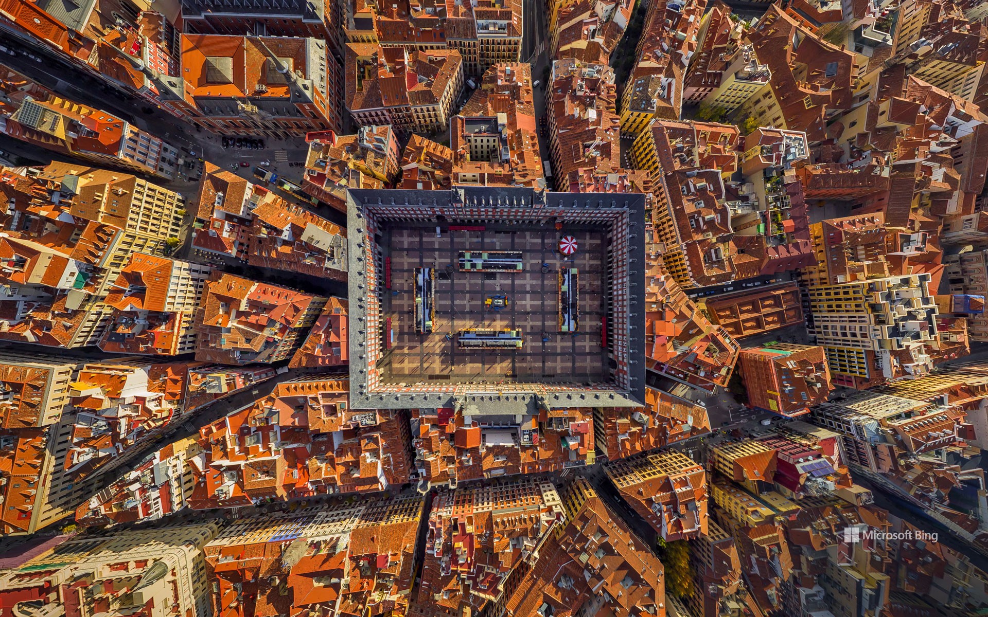
马约尔广场鸟瞰图, 马德里, 西班牙 Aerial view of Plaza Mayor, Madrid, Spain (© AirPano LLC/Amazing Aerial Agency)
网格的心脏 The heart of the grid
马约尔广场鸟瞰图, 马德里,西班牙
从高处俯瞰,马德里(西班牙首都)的马约尔广场(Plaza Mayor)上,整齐的拱廊与瓦片屋顶交织成一幅令人着迷的建筑和谐画卷。这片历史悠久的空间曾是热闹的集市广场“阿拉巴尔广场”(Plaza del Arrabal)的所在地,见证了这座城市数百年来的变迁。这一转变始于1561年,当时皇家法院从托莱多迁至马德里,广场随之归入马德里管辖。受秩序与宏伟愿景的启发,菲利普二世重新构想了这片广场——尽管实际施工直至菲利普三世统治时期的1617年才正式展开。
该广场采用矩形布局,四周环绕着三层高的建筑,共设有237个朝内的阳台。广场共有十个入口,其中九个设有门禁。广场中央矗立着菲利普三世的骑马雕像,该雕像于1848年增设。多年来,该广场曾举办过从地方节庆、斗牛活动到封圣仪式和皇家典礼等各类活动。如今,它仍是一个充满活力的聚集地,举办复活节鼓乐游行、户外音乐会、年度圣诞市场,以及每周日早上的邮票和硬币收藏家市场。
Aerial view of Plaza Mayor, Madrid, Spain
Seen from above, the uniform arcades and tiled rooftops of Plaza Mayor in Madrid—the capital of Spain—create a captivating architectural harmony. Once the site of a bustling market square known as the Plaza del Arrabal, this historic space has witnessed the city's transformation over the centuries. The shift began in 1561, when the plaza came under Madrid's jurisdiction after the royal court moved from Toledo. Inspired by a vision of order and grandeur, King Philip II reimagined the square—though construction did not actually begin until 1617, under the reign of Philip III.
Featuring a rectangular layout, the plaza is framed by three-story buildings with 237 inward-facing balconies. It has 10 entrances, nine of which are gated. At its center stands the equestrian statue of Philip III, added in 1848. Over the years, the square has hosted everything from local festivities and bullfights to beatifications and royal ceremonies. Today, it remains a vibrant gathering place, featuring Easter drum parades, outdoor concerts, an annual Christmas market, and a Sunday morning market for stamp and coin collectors.
瑟沃格湖,瓦加尔岛,法罗群岛 Sørvágsvatn lake, island of Vágar, Faroe Islands, Denmark (© Anton Petrus/Getty Images)
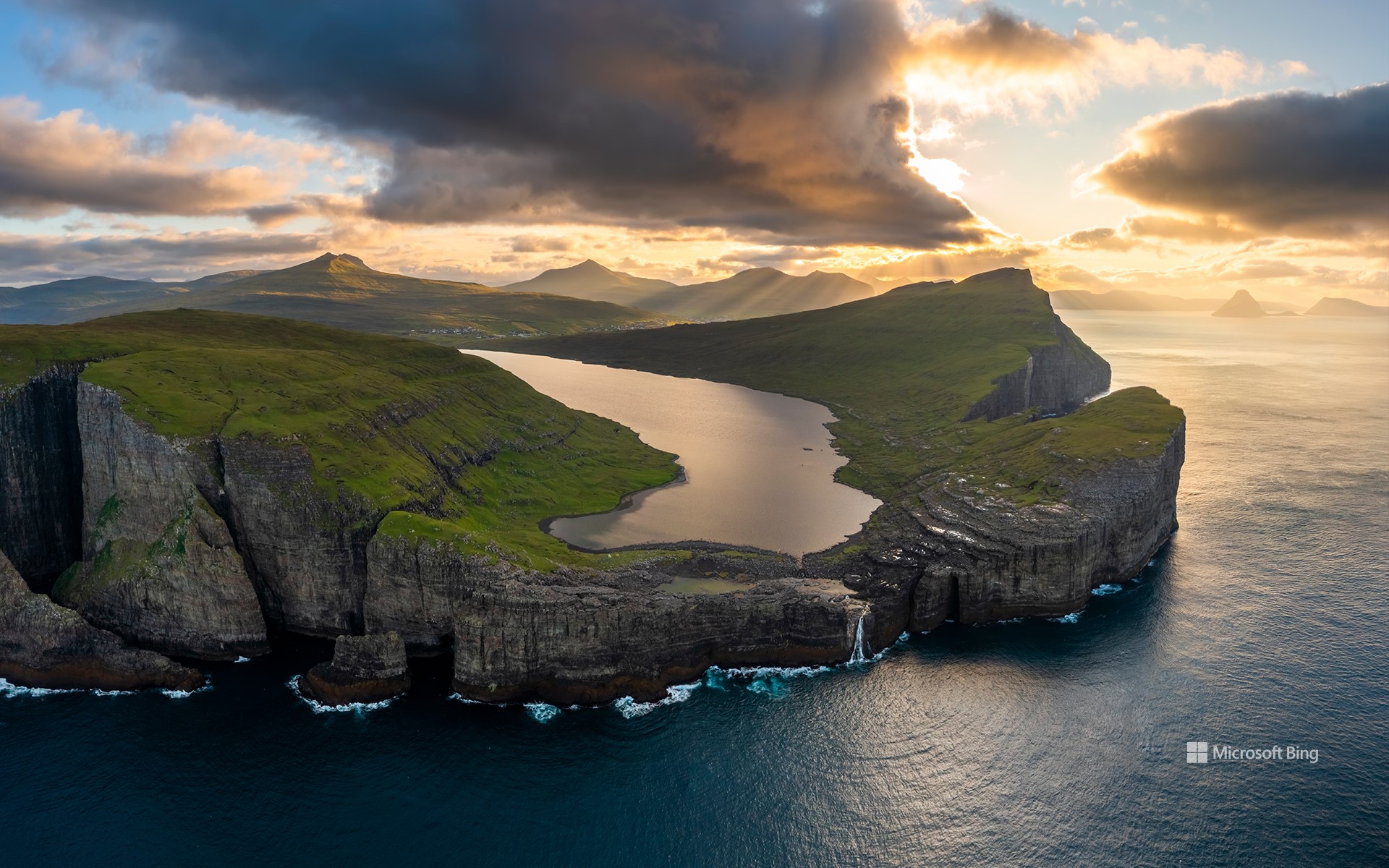
瑟沃格湖,瓦加尔岛,法罗群岛 Sørvágsvatn lake, island of Vágar, Faroe Islands, Denmark (© Anton Petrus/Getty Images)
海洋上方的湖泊 A lake above the ocean
世界湖泊日
大自然自有其奇妙之处,瑟沃格湖(Sørvágsvatn)便是其中最精彩的之一。世界湖泊日是探索法罗群岛(丹麦王国的一个自治行政区)这片视错觉的绝佳时机。这座位于沃格岛上的湖泊也被称为莱蒂斯湖(Leitisvatn),看似漂浮在海平面之上。实际上,它的海拔不到100英尺。索尔瓦格斯湖是法罗群岛最大的湖泊,面积约1.3平方英里,为Bøsdalafossur瀑布Bøsdalafossur提供水源,瀑布的湖水在那里奔腾而下,最终倾泻而入大海。
值此世界湖泊日之际,瑟沃格湖(Sørvágsvatn)提醒我们湖泊的重要性。它们不仅提供休闲娱乐,还储存淡水,调节当地气候,并支持生物多样性。然而,如今许多湖泊正面临威胁。污染、过度使用、气候变化和水位波动正给这些脆弱的生态系统带来越来越大的压力。所以,下次看地图时,请将湖泊视为不仅仅是蓝色的点,而是我们这个世界中充满生机、值得我们关爱和关注的部分
World Lake Day in the Faroe Islands
Nature has its tricks, and Sørvágsvatn is one of its best. World Lake Day is the perfect occasion to explore this optical illusion in the Faroe Islands, an autonomous administrative division of the Kingdom of Denmark. Also called Leitisvatn, this lake on the island of Vágar appears to float far above the ocean. In reality, it sits less than 100 feet above sea level. As the largest lake in the Faroes, Sørvágsvatn has a surface area of about 1.3 square miles and feeds the Bøsdalafossur waterfall, where its waters pour dramatically into the sea.
As we mark World Lake Day, Sørvágsvatn reminds us why lakes are so vital. They not only provide recreation but also store freshwater, regulate local climates, and support biodiversity. Yet today, many are under threat. Pollution, overuse, climate change, and fluctuating water levels are placing increasing pressure on these fragile ecosystems. So, the next time you look at a map, think of lakes not just as dots of blue but as living, breathing parts of our world that deserve our care and attention.
阿尔贝罗贝洛的特鲁洛建筑,普利亚大区,意大利 Trullo buildings in Alberobello, Apulia, Italy (© Feng Wei Photography/Getty Images)
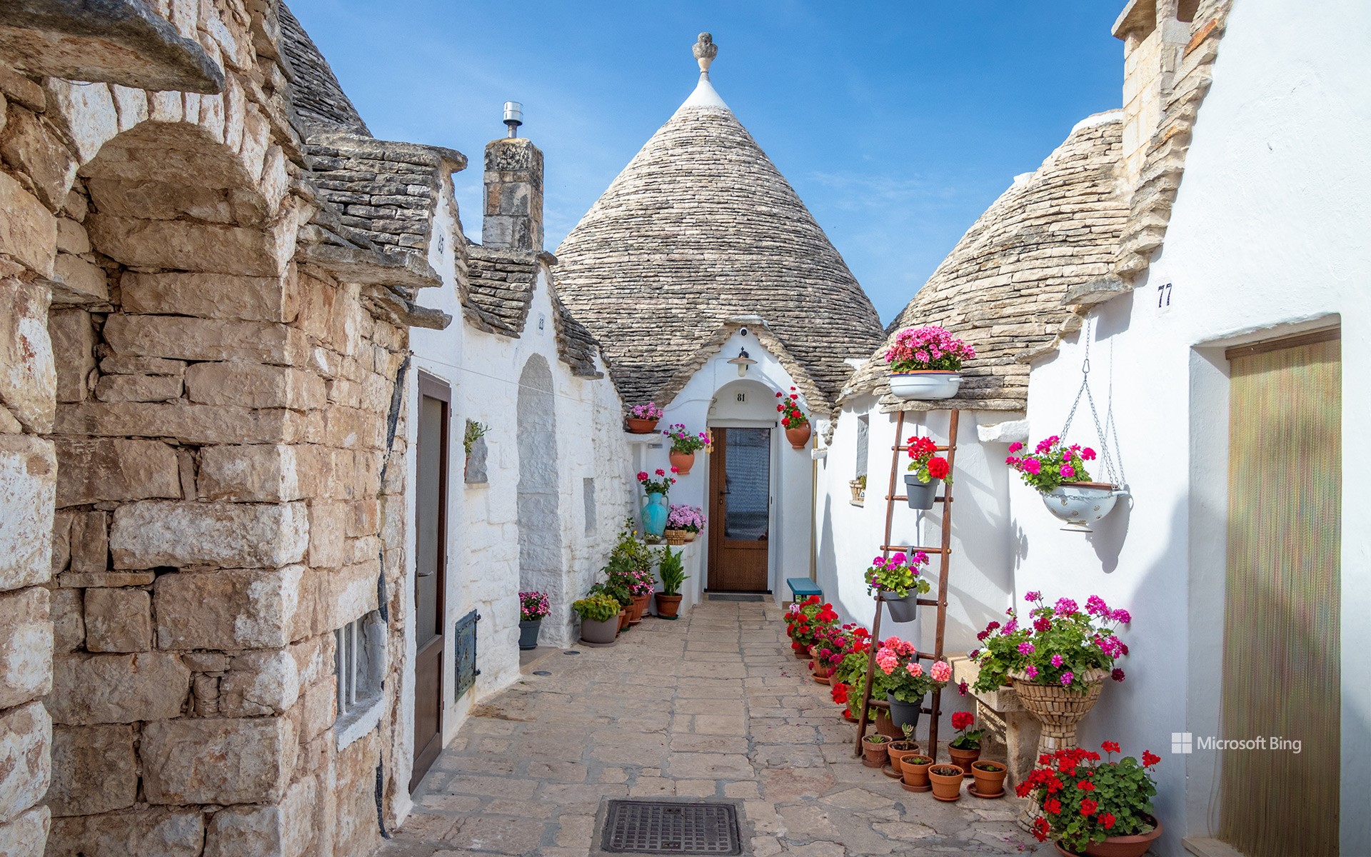
阿尔贝罗贝洛的特鲁洛建筑,普利亚大区,意大利 Trullo buildings in Alberobello, Apulia, Italy (© Feng Wei Photography/Getty Images)
一座非凡的特鲁洛小镇 A 'trulli' remarkable town
阿尔贝罗贝洛的特鲁洛建筑,意大利
如果童话故事里有建筑师,他们或许能创造出像意大利阿尔贝罗贝洛那样的景象。但这座小镇的标志性建筑——特鲁利(trulli,单数为trullo),并非靠魔杖,而是石灰岩、无砂浆砌筑,以及——根据某些理论——一些逃税手段——才得以建成。这些粉刷过的石屋顶部是干砌的石灰岩屋顶,形状像倒置的冰淇淋蛋筒。这是一种古老的建筑技术,在阿尔贝罗贝洛,更是巧妙之举。据说早在14世纪,当地人就试图通过建造房屋来逃避房产税,因为国王的税务官来袭时,这些房屋很容易被拆除。
阿尔贝罗贝洛的特鲁利并非孤例。像蒙蒂区(Rione Monti)和小阿亚区(Aia Piccola)这样的整个街区都挤满了这些奇特的建筑。有些至今仍有人居住,有些则被改造成咖啡馆、纪念品商店和小型博物馆。你甚至还能找到一座特鲁利风格的教堂。1996年,联合国教科文组织将阿尔贝罗贝洛的特鲁利列为世界遗产。一个漏洞成为地标建筑的情况并非每天都有。
Trullo buildings in Alberobello, Apulia, Italy
If fairy tales had architects, they might've come up with something like Alberobello in Italy. But instead of magic wands, it was limestone, mortar-free masonry, and—according to some theories—a bit of tax evasion that built this town's signature homes: the trulli. These are whitewashed stone houses topped with dry-stacked limestone roofs shaped like upside-down ice cream cones. It's an ancient building technique, and in this case, a clever one. Back in the 14th century, locals were reportedly trying to avoid property taxes by constructing homes that could be quickly dismantled when the king's tax collector came around.
Alberobello's trulli aren't hidden one-offs. Entire districts—like Rione Monti and Aia Piccola—are packed with these quirky structures. Some are still lived in, while others have been transformed into cafés, souvenir shops, and pint-sized museums. You'll even find a church built in trullo style. In 1996, UNESCO gave the trulli of Alberobello the heritage stamp of approval. It's not every day that a loophole becomes a landmark.
方解石温泉区和黄石河,黄石国家公园,怀俄明州,美国 Calcite Springs Overlook and Yellowstone River, Yellowstone National Park, Wyoming (© Rebecca L. Latson/Getty Images)
方解石温泉区和黄石河,黄石国家公园,怀俄明州,美国 Calcite Springs Overlook and Yellowstone River, Yellowstone National Park, Wyoming (© Rebecca L. Latson/Getty Images)
从火山之源到河流之路 From volcanic roots to river routes
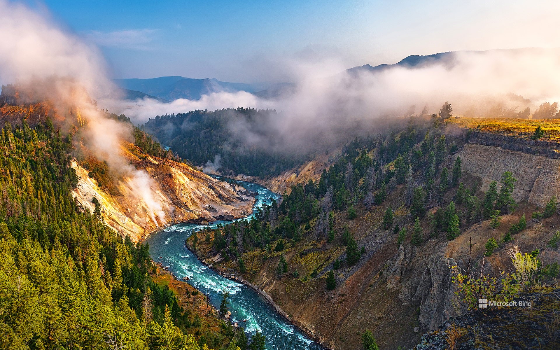
方解石温泉区和黄石河,美国
黄石河是美国本土48州最后一条未建坝的主要河流,它从黄石公园东南方向发源,全长671英里(1080公里),汇入密苏里河,最终汇入大西洋。这座地热与峡谷交汇的观景台,让您近距离欣赏黄石河蜿蜒流经熔岩锻造的峡谷的壮丽景色。沿着玄武岩峭壁,可以看到富含矿物质的地下水仍在冒着热气,形成了白色的矿藏,方解石泉也因此得名。您或许还能看到白头鹰在头顶滑翔,或是野牛在附近悠闲地休息。黄石公园不仅仅是一个公园,它更是一座拥有游客中心的超级火山。
Yellowstone for the National Park Service's birthday
Today, the National Park Service celebrates another trip around the sun—and nearly 85 million acres of American beauty under its care. From geysers that spout like soda cans to ancient cliff dwellings tucked into canyon walls, the NPS has spent over a century preserving, protecting, and inviting people to take a hike—literally. In 1916, President Woodrow Wilson signed the Organic Act into law, officially creating the NPS to 'conserve the scenery and the natural and historic objects.' Since then, the NPS has grown to oversee more than 400 sites, including national parks, battlefields, monuments, and seashores.
What better spot to toast the occasion than the Calcite Springs Overlook in Yellowstone National Park, Wyoming? This thermal-meets-canyon overlook offers front-row views of the Yellowstone River carving its way through a lava-forged canyon. Along the basalt cliffs, white mineral deposits that gave Calcite Springs its name are visible, formed by mineral-rich waters still steaming from underground. You might spot a bald eagle gliding overhead or bison lounging nearby. Yellowstone is more than just a park—it's a supervolcano with a visitor center.