豪滕镇的彩虹屋, 荷兰 The Rainbow Houses of Houten, Netherlands (© George Pachantouris/Getty Images)
豪滕镇的彩虹屋, 荷兰 The Rainbow Houses of Houten, Netherlands (© George Pachantouris/Getty Images)
彩虹骑行与宁静氛围 Rainbow rides and quiet vibes
彩虹屋,荷兰豪滕
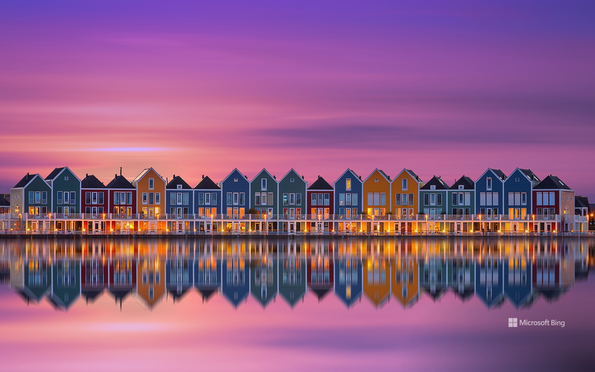
你不会找到纪念品商店或旅游地图指引方向——但沿着豪滕的里特普拉斯湖畔,你会偶然发现荷兰最令人意想不到的上镜景点之一。虽然许多人涌向阿姆斯特丹的运河或鹿特丹的方块屋,但这座宁静的通勤小镇却拥有独特的建筑风格。彩虹屋如海市蜃楼般鳞次栉比,闪耀着大胆的绘画色彩——一个住宅区变成了一个低调的文化地标。
对当地人来说,它们只是日常生活的一部分。但对于摄影师和设计爱好者来说,它们是色彩饱和、对称的梦幻景观。该建筑群由汉斯·比恩 (Hans Been) 设计,于 2005 年竣工,将加勒比海风情与北欧的内敛风格融为一体,呼应了简约渔村的面貌。每栋房子都反射出不同的色彩。这不是一个精心策划的旅游景点;这些都是有人居住的住宅,它们所在的社区也经过了同样周到的规划,而豪滕正是凭借这种规划成为全国最适合骑自行车的城镇之一。从湖对岸或附近的桥上欣赏这些色彩鲜艳的建筑外观最为理想,它们就像一个秘密,只有在合适的光线下才能幸运地捕捉到:迷人、惊喜,而且低调得令人耳目一新。
The Rainbow Houses of Houten, Netherlands
You won't find souvenir shops or tourist maps pointing the way—but follow the edge of Lake Rietplas in Houten, and you'll stumble upon one of the Netherlands' most unexpectedly photogenic sights. While many flock to Amsterdam's canals or Rotterdam's cube houses, this quiet commuter town offers its own architectural twist. Lined up like a mirage, the Rainbow Houses shimmer in bold, painterly hues—a residential block turned an understated cultural landmark.
To locals, they're simply part of the daily backdrop. But for photographers and design lovers, they're a dreamscape of saturation and symmetry. Designed by Hans Been and completed in 2005, the ensemble blends Caribbean flair with Nordic restraint, echoing the look of a minimalist fishing village. Each house reflects a different color of the spectrum. This isn't a curated tourist stop; these are lived-in homes, part of a neighborhood shaped by the same thoughtful planning that makes Houten one of the most bike-friendly towns in the country. Best seen from across the lake or a nearby bridge, these vibrant facades feel like a secret you're lucky to catch in the right light: charming, surprising, and refreshingly under the radar.
托斯卡纳的皮恩扎镇, 意大利 Town of Pienza in Tuscany, Italy (© zpagistock/Getty Images)
托斯卡纳的皮恩扎镇, 意大利 Town of Pienza in Tuscany, Italy (© zpagistock/Getty Images)
品味皮恩扎 A taste of Pienza
托斯卡纳的皮恩扎镇, 意大利
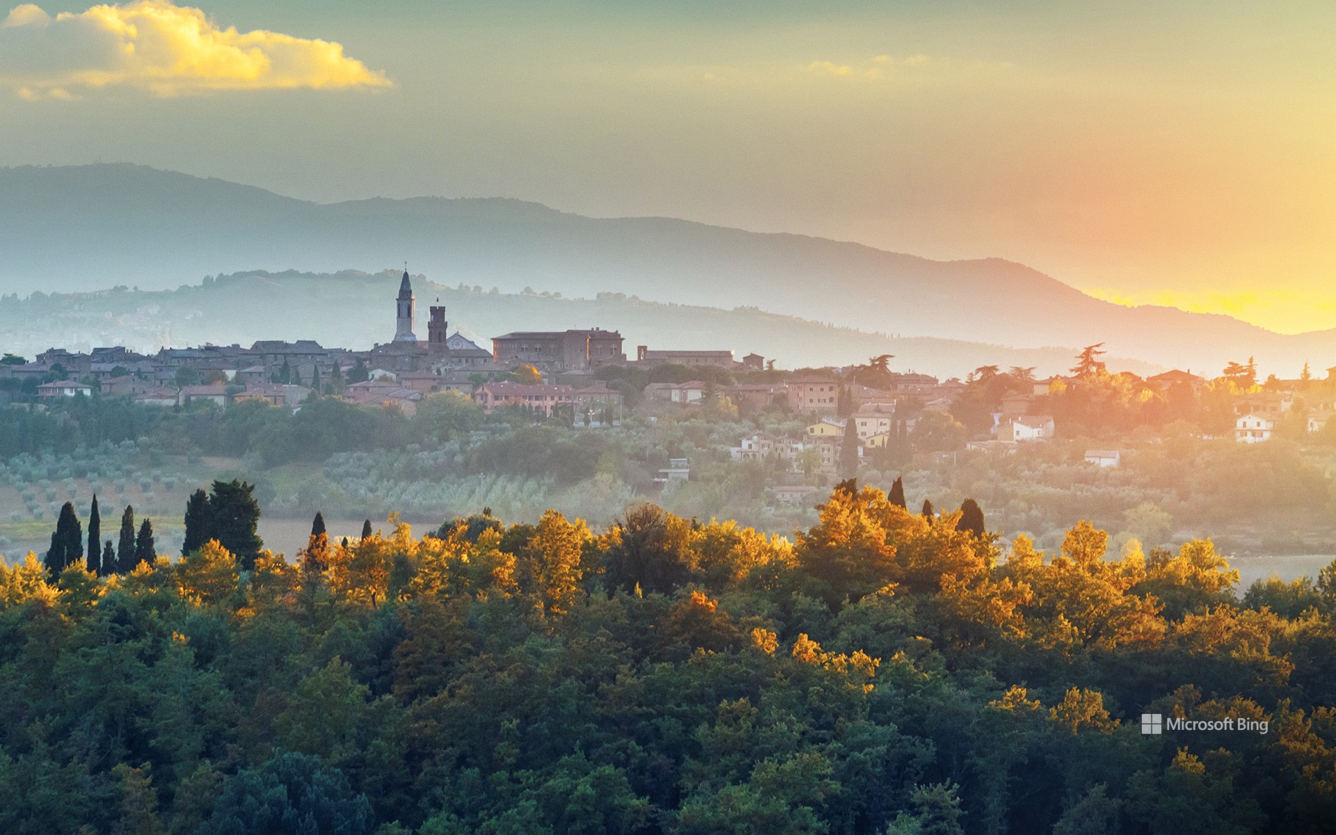
有些城镇历经数个世纪缓慢演变。皮恩扎?15世纪,一位教皇为了证明某种观点——或许也为了炫耀——彻底重塑了它。这座意大利小镇坐落在奥尔恰山谷之上,周围环绕着连绵起伏的群山,其景象与你想象中的托斯卡纳一模一样:柏树成荫,蜿蜒的土路,偶尔还能看到几只绵羊。它宁静祥和。而当你踏入城墙,它便会变得灵动起来。
皮恩扎曾是一个普通的中世纪村庄,名叫科尔西尼亚诺。直到教皇庇护二世的儿子决定改造他的家乡,他聘请了建筑师贝尔纳多·罗塞利诺,按照文艺复兴时期的对称、秩序与和谐理念重建了这片区域。结果如何?这片区域仿佛是经过精心设计的。中心广场皮奥二世广场两侧分别矗立着大教堂、教皇宫殿和市政厅,布局也恰到好处。此外,皮恩扎还以佩科里诺奶酪而闻名——这是一种以羊奶为原料,以独特的方式陈酿而成的奶酪。每年一次,整个小镇都会变成奶酪竞技场,举办“奶酪节”(Fiera del Cacio),这是一个以“奶酪轮”(Cacio al Fuso)为特色的节日——这是一种人们将奶酪轮滚向目标的游戏。
The town of Pienza in Tuscany, Italy
Some towns evolve slowly over centuries. Pienza? It received a full rebrand in the 1400s from a pope who wanted to prove a point—and maybe show off a little. This tiny Italian town is perched above the Val d'Orcia, surrounded by rolling hills that look exactly like you think Tuscany should: cypress trees, winding dirt roads, the occasional sheep. It's peaceful. And then you step inside the town walls, and it gets clever.
Pienza was once a regular medieval village called Corsignano. That is, until one of its sons became Pope Pius II and decided to transform his hometown. He hired architect Bernardo Rossellino and rebuilt the area based on Renaissance ideals of symmetry, order, and harmony. The result? A site that feels intentional. The central square, Piazza Pio II, is flanked by a cathedral, a papal palace, and a town hall, all arranged just so. Moreover, Pienza is known for pecorino cheese—sheep's milk, aged in interesting ways. And once a year, the whole town turns into a cheese arena for Fiera del Cacio, a festival featuring Cacio al Fuso—a game where people roll wheels of cheese at a target.
坦克湖 (Tank Lakes), 高山湖泊荒野区, 华盛顿州, 美国 Tank Lakes, Alpine Lakes Wilderness, Washington (© Austin Trigg/TANDEM Stills + Motion)

坦克湖 (Tank Lakes), 高山湖泊荒野区, 华盛顿州, 美国 Tank Lakes, Alpine Lakes Wilderness, Washington (© Austin Trigg/TANDEM Stills + Motion)
美丽的星空 Weeding and wishing
坦克湖, 高山湖泊荒野区, 华盛顿
今天图片中璀璨的星空来自于坦克湖,它位于高山湖泊荒野区。高山湖泊荒野占地超过40万英亩,位于风景如画的华盛顿州中部喀斯喀特山脉。荒野位于喀斯喀特山脉北段的斯诺夸米山口和史蒂文斯山口之间,其中包括被称为韦纳奇山脉的子山脉,该山脉构成了韦纳奇-雅基马分水岭。
这片荒野由冰川侵蚀而成,点缀着700多个湖泊。许多山峰和山坡终年被雪原覆盖。从生长着花旗松、雪松的湿润森林,到生长着沙拉树和浆果的林下层,这片地貌逐渐延伸至低矮植物覆盖的广阔草甸,最终以生长着黄松的干燥林地结束。
Astronomy Day and National Public Lands Day
When the calendar lines up just right, you get a rare double feature: National Public Lands Day and Astronomy Day. It's a chance to explore the landscapes that ground us and the skies that inspire us—all within 24 hours.
National Public Lands Day, held on the fourth Saturday of September, is America's biggest single-day volunteer event for parks, forests, and other shared spaces. Volunteers rake, plant, and pick up litter—all while enjoying free admission to these sites. Astronomy Day comes twice a year, with the fall version offering longer nights and darker skies. The goal is simple: help more people discover the universe. Many parks are far from city lights, making them prime spots for seeing the Milky Way, meteor showers, and constellations without interference. Remote places like Tank Lakes in Washington's Alpine Lakes Wilderness, pictured here, offer exactly that.
This year, why not make it a two-for-one celebration? Hike a trail by day, then trace constellations by night. On National Public Lands Day, you might cross paths with a deer or eagle. On Astronomy Day, your companions could be Orion or Cassiopeia. Different worlds, same sense of wonder.
奇陶尔加尔堡, 拉贾斯坦邦, 印度 Chittorgarh Fort, Rajasthan, India (© chetansoni/Shutterstock)
奇陶尔加尔堡, 拉贾斯坦邦, 印度 Chittorgarh Fort, Rajasthan, India (© chetansoni/Shutterstock)
忠勇的雕刻石 Carved stones of courage
奇陶尔加尔堡, 拉贾斯坦邦, 印度
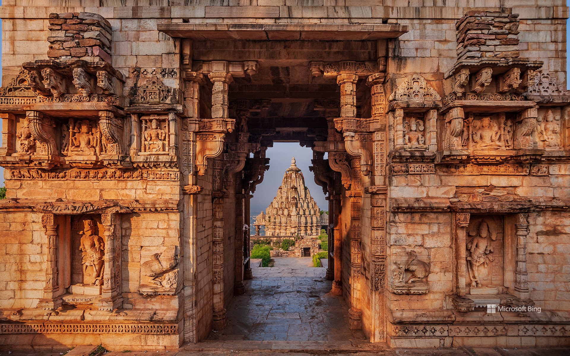
奇陶尔加尔堡坐落在印度拉贾斯坦邦一座海拔超过590英尺的山丘上,占地约690英亩。它骄傲地见证着著名武士家族——拉杰普特人的英勇事迹。拉杰普特人的名字源自梵语“rajaputra”,意为“国王之子”,他们以其高贵的血统和尚武传统而闻名于整个印度北部。这座堡垒的石墙见证了几个世纪以来拉贾斯坦邦吟游诗人的歌谣中流传的勇气、骄傲和浪漫。据传说,印度史诗《摩诃婆罗多》中的英雄比姆是这座堡垒的奠基者。
奇陶尔加尔堡是印度最大的堡垒之一,拥有65座历史建筑,包括四座宫殿、19座大型寺庙、20座水库、四座纪念碑和几座胜利塔。这座堡垒周长约8.1英里,最长3.1英里。从平原出发,沿着一条陡峭的之字形山路蜿蜒而上,全长约半英里,从横跨甘比里河的石灰岩桥开始。沿着这条路攀登,穿过古老的城门,您仿佛能听到战争和传说的回响——仿佛在邀请您踏入一段鲜活的历史篇章。
Chittorgarh Fort, Rajasthan, India
High on a hill rising over 590 feet in Rajasthan, India, Chittorgarh Fort spans approximately 690 acres. It stands as a proud witness to the valor of the famed warrior clans—the Rajputs. Their name comes from the Sanskrit 'rajaputra,' meaning 'son of a king,' and they are celebrated for their noble lineage and martial traditions across northern India. The fort's stone walls have witnessed centuries of courage, pride, and romance, remembered in the songs of Rajasthan's bards. According to legend, Bhim, a hero from the Hindu epic 'Mahabharata,' first laid its foundations.
As one of the largest forts in India, Chittorgarh encompasses 65 historic structures, including four palaces, 19 large temples, 20 reservoirs, four memorials, and several victory towers. This fort has a circumference of about 8.1 miles and a maximum length of 3.1 miles. It is reached by a steep, zigzag ascent of just over half a mile from the plains, beginning with a limestone bridge over the Gambhiri River. Climbing this path and passing through its ancient gates, you can almost hear the echoes of battles and legends—inviting you to step into a living chapter of history.
魔鬼塔国家纪念碑, 怀俄明州,美国 Devils Tower National Monument, Wyoming (© Laura Hedien/Getty Images)
魔鬼塔国家纪念碑, 怀俄明州,美国 Devils Tower National Monument, Wyoming (© Laura Hedien/Getty Images)
孤独的巨人 The lonely giant
怀俄明州魔鬼塔国家纪念碑
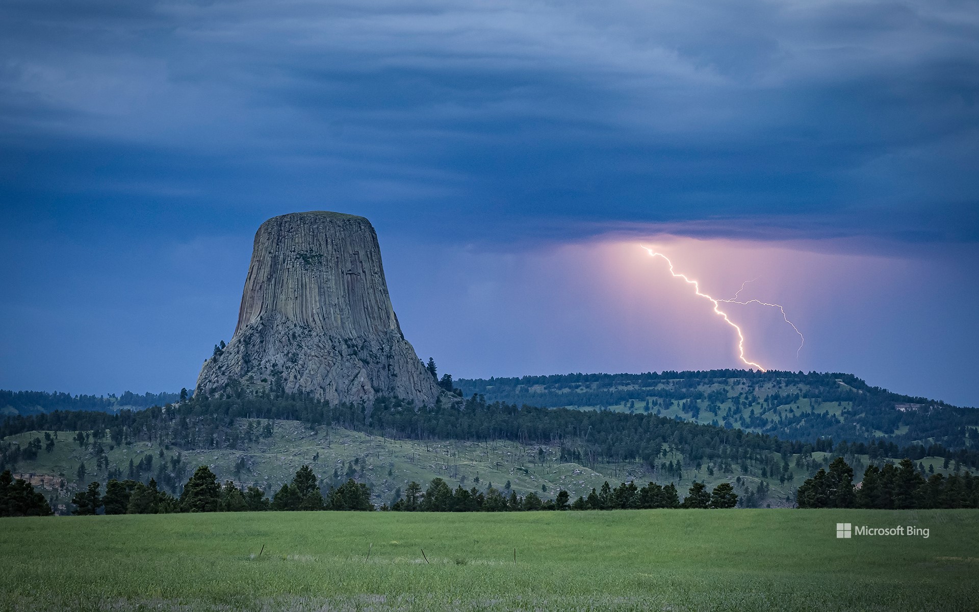
在怀俄明州东北部辽阔的草原上,矗立着魔鬼塔——一座从开阔平原拔地而起的岩石地貌。这座山丘原名熊屋,在1875年理查德·欧文·道奇上校率领的探险队中获得现名,据推测可能源于一名翻译将原住民的表述误译为“恶神之塔”。其官方名称省略的撇号符合标准地理命名惯例——因此路标均标注为“魔鬼塔”。1906年,西奥多·罗斯福总统将其指定为美国首个国家纪念碑,这一里程碑事件的周年纪念日正值今日。
当你驶向魔鬼塔时,每道弯道都揭开新的景致——无论你从高速公路而来,沿着蜿蜒小路驶向游客中心,还是徒步踏上塔径。这片土地的意义远不止于其壮丽的地质景观。数百年间,来自大平原与黑丘地区的众多部落——包括阿拉帕霍族、乌鸦族和夏延族——都与这片土地有着深厚渊源。每个部落都传承着关于魔鬼塔起源的口述传说。尽管诸多传说存在共通主题,但细节却在每个族群中独具特色。魔鬼塔始终承载着地质演变、文化传承以及人类与自然世界间永恒变迁关系的鲜活史诗。
Devils Tower National Monument, Wyoming
Somewhere in the wide prairies of northeastern Wyoming stands Devils Tower, a stone formation that rises from the open plains. Once called Bear Lodge, the butte gained its current name during an 1875 expedition led by Colonel Richard Irving Dodge, possibly after an interpreter mistranslated a Native phrase as 'Bad God's Tower.' The missing apostrophe in its official title follows standard geographic naming conventions—hence, the signs read 'Devils Tower.' In 1906, President Theodore Roosevelt proclaimed it the nation's first national monument; a milestone whose anniversary falls today.
As you approach Devils Tower, every curve in the road unveils a new view—whether you're arriving from the highway, winding toward the visitor center, or following the Tower Trail on foot. The site's significance stretches far deeper than its dramatic geology. For centuries, numerous tribes from the Great Plains and Black Hills, including the Arapaho, Crow, and Cheyenne, have been linked to this place. Each tribe preserves oral traditions about the Tower's creation. While many of these accounts share recurring themes, the details remain unique to every community. Devils Tower continues to embody a living chronicle of geology, heritage, and the ever-changing relationship between humans and the natural world.
航拍中国江苏省常州翠竹公园 Aerial view of Cuizhu Park in Changzhou, Jiangsu Province, China (© Xu Changyu/Getty images)
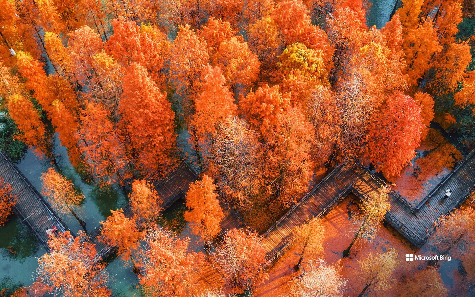
航拍中国江苏省常州翠竹公园 Aerial view of Cuizhu Park in Changzhou, Jiangsu Province, China (© Xu Changyu/Getty images)
树树皆秋色 Autumn colours everywhere
秋分
又是一年的秋分时节,众所周知,在这一天,全球各地昼夜的时间几乎是相等的。在幅员辽阔的中国,自南向北开始,秋季在每个地区有着不同颜色和不同的温度。大部分地区雨季在此时刚刚结束,秋天的凉意才刚刚开始,此时正是碧空万里,风和日丽的时节。中国的秋季颜色是叠翠鎏金的,许多植物的颜色由此时节开始,由苍翠的绿转为金黄或者橙红色。
今天我们的图片中正是秋季最具代表性的红色落羽杉,它们位于江苏省常州的翠竹公园,每年秋冬季节,落羽杉皆呈现出金黄至橙红色的渐变,搭配九曲回廊与水上栈道,是一派诗意盎然的江南秋季风景。
慕尼黑啤酒节上的旋转木马,慕尼黑,巴伐利亚,德国 Swing carousel at Oktoberfest, Munich, Germany (© LOOK-foto/Alamy)

慕尼黑啤酒节上的旋转木马,慕尼黑,巴伐利亚,德国 Swing carousel at Oktoberfest, Munich, Germany (© LOOK-foto/Alamy)
关于啤酒和风景的故事 A tale of brews and views
啤酒节开始了!
每年秋天,德国慕尼黑的特蕾莎草地都会摇身一变,成为全球最大的节日之一——慕尼黑啤酒节。啤酒节最初于1810年为庆祝一场皇室婚礼而举办,如今已发展成为一个持续16至18天的传统节日,吸引着来自世界各地的600多万人参加。啤酒节的规模令人叹为观止:场地占地约450万平方英尺,设有14个主帐篷,每个帐篷可容纳数千人。每年,游客们会喝掉约700万升啤酒,以及堆积如山的椒盐脆饼、香肠和姜饼心。慕尼黑啤酒节上供应的所有啤酒均来自慕尼黑啤酒厂,并符合德国啤酒纯度法(Reinheitsgebot)的严格标准。
除了美酒佳肴,广阔的游乐场本身就是一个世界,里面充满了过山车、游戏和经典游乐设施。其中,旋转木马“Wellenflug”(如图所示)可以一览节日场地和慕尼黑天际线的壮丽景色。今年的啤酒节从今天开始,一直持续到10月5日。无论您是来啤酒、椒盐脆饼,还是来体验在城市上空翱翔的刺激,啤酒节都能满足您的需求。
Oktoberfest begins!
Every fall, Theresienwiese, a square in Munich, Germany, transforms into one of the world's largest festivals—Oktoberfest. First held in 1810 to celebrate a royal wedding, it has grown into a 16- to 18-day tradition attracting more than 6 million people from around the globe. The scale is staggering: The festival grounds span about 4.5 million square feet and host 14 main tents, each seating thousands. Each year, visitors consume around 7 million liters of beer, along with mountains of pretzels, sausages, and gingerbread hearts. All beer served at Oktoberfest comes from Munich breweries and meets the strict standards of the Reinheitsgebot, the German Beer Purity Law.
Beyond the drinks and food, the sprawling fairground is its own world, filled with roller coasters, games, and classic rides. Among them, the Wellenflug, the swing carousel pictured here, offers sweeping views of the festival grounds and the Munich skyline. This year, the festival begins today and runs through October 5. Whether you come for the beer, the pretzels, or the thrill of dangling your feet high above the city, Oktoberfest has a seat waiting for you.
千岛群岛地区,圣劳伦斯河,美加边境 Thousand Islands region, St. Lawrence River, US-Canada border (© benedek/Getty Images)
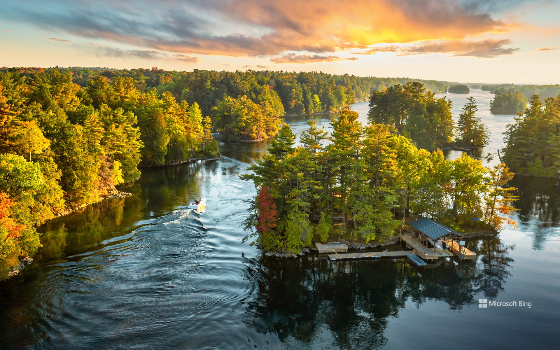
千岛群岛地区,圣劳伦斯河,美加边境 Thousand Islands region, St. Lawrence River, US-Canada border (© benedek/Getty Images)
千般理由,邀您探索 A thousand reasons to visit
千岛群岛地区,圣劳伦斯河,美加边境
听到“千岛”这个词,你可能会想到一罐沙拉酱,但在这浓郁的酱汁背后,是北美最迷人的地区之一。千岛群岛是圣劳伦斯河上的一个群岛,横跨美国纽约州和加拿大安大略省。它由1800多个岛屿组成。有些岛屿上矗立着童话般的城堡,有些岛屿则狭小得几乎容不下一张吊床。此外,还有一座名为“刚好够住的岛”(Just Room Enough Island),岛上只有一栋房子和一棵孤树,名副其实。
该地区非常适合慢节奏的探索。乘船游览将带您经过宏伟的庄园和历史悠久的灯塔,途中常会停靠伯特城堡(Boldt Castle)和辛格城堡(Singer Castle)等标志性景点。皮划艇爱好者被该地区清澈的海水和宁静的海湾所吸引。得益于独特的微气候,当地酿酒师酿造出屡获殊荣的葡萄酒,值得一试。哦,还有沙拉酱?传说中,一位当地钓鱼向导的妻子首次为晚宴客人制作了这道酱料,其中包括女演员梅·欧文,她对这道酱料赞不绝口,甚至请求获得了配方。正如人们所说,这段历史堪称美味传奇。
Thousand Islands region, St. Lawrence River, US-Canada border
When you hear 'Thousand Islands,' you might think of a jar of salad dressing, but the namesake of that creamy condiment is one of North America's most enchanting regions. The Thousand Islands form an archipelago in the St. Lawrence River, spanning the state of New York and the province of Ontario. It is made up of more than 1,800 islands. Some of these islands have fairytale castles; others are barely big enough for a hammock. There's also Just Room Enough Island, which lives up to its name with a single house and a lone tree.
The Thousand Islands are perfect for slow-paced exploration. Boat tours take you past grand estates and historic lighthouses, often stopping at landmarks like Boldt Castle and Singer Castle. Kayakers are drawn to the region's clear waters and serene coves. Thanks to a unique microclimate, local winemakers craft award-winning wines that are well worth sampling. Oh, and the salad dressing? Legend says a local fishing guide's wife first created it for dinner guests, including actress May Irwin, who enjoyed it so much that she asked for the recipe. The rest, as they say, is delicious history.
邓金码头的蛇形楼梯, 凯里郡, 爱尔兰 Serpentine stairs of Dunquin Pier, County Kerry, Ireland (© Hugh O'Connor/Getty Images)

邓金码头的蛇形楼梯, 凯里郡, 爱尔兰 Serpentine stairs of Dunquin Pier, County Kerry, Ireland (© Hugh O'Connor/Getty Images)
爱尔兰岛的西端 Ireland's western edge
邓金码头, 凯里郡, 爱尔兰
这片令人惊叹的景色——天空与大西洋的浩瀚水域相接之处——只能徒步抵达。位于爱尔兰荒野而美丽的丁格尔半岛上,邓金码头是凯里郡最适合拍照的景点之一。这座小型码头以蜿蜒曲折的盘山小径闻名,小径如丝带般在悬崖边剧烈蜿蜒而下。这些陡峭的弯道不仅带来刺激感,更是通往下方码头的唯一路径,从这里出发的船只将驶向偏远的布拉斯凯特群岛。
附近的邓金村(爱尔兰语:Dún Chaoin)是爱尔兰最西端的聚居地,拥有壮丽的视野和深厚的爱尔兰文化底蕴。邓金人口仅略超过100人,以浓厚的盖尔语传统、故事讲述和与布拉斯克特群岛作家们的联系而闻名。游客常会造访布拉斯克特中心,这座文化博物馆讲述了岛上生活与移民的故事。无论您是被壮丽的自然景观吸引,还是被丰富的文化遗产所打动,邓金都提供了一种独特而永恒的爱尔兰体验,令人难忘。
Dunquin Pier, County Kerry, Ireland
This stunning view—where the sky meets the open waters of the Atlantic—is accessible only by foot. Tucked away on Ireland's wild and beautiful Dingle Peninsula, Dunquin Pier is one of the most photogenic spots in County Kerry. The small pier is famous for its winding, serpentine path that zigzags dramatically down the cliffside like a ribbon. These steep curves aren't just for the thrill—they're the only way to reach the pier below, where boats depart for the remote Blasket Islands.
The nearby village of Dunquin (Dún Chaoin in Irish) is Ireland's westernmost settlement, offering sweeping views and a deep connection to Irish heritage. With a population of just over 100, Dunquin is known for its strong Gaelic traditions, storytelling, and ties to the Blasket Island writers. Visitors often stop at the Blasket Centre, a cultural museum that tells the story of island life and emigration. Whether you're drawn by the dramatic landscape or the rich cultural heritage, Dunquin offers a uniquely Irish experience that feels both timeless and unforgettable.
从地球上空225英里处俯瞰墨西哥湾沿岸各州的夜间景象 Nighttime view of the Gulf Coast states from 225 miles above Earth (© Stocktrek Images/Getty Images)

从地球上空225英里处俯瞰墨西哥湾沿岸各州的夜间景象 Nighttime view of the Gulf Coast states from 225 miles above Earth (© Stocktrek Images/Getty Images)
巨大的成功 A stratospheric success
墨西哥湾沿岸的夜景
看不见的气体、老式发胶和卫星有什么共同点?它们都在历史上最伟大的环境复苏之一中发挥了作用。从225英里高空俯瞰,墨西哥湾沿岸如同一片星辰——点点灯光散落在黑暗中。但真正让这一景象成为可能的,却是肉眼无法看见的:臭氧层,它默默地保护着下方的一切免受太阳紫外线的侵害。到了20世纪80年代,这层屏障正迅速变薄——被曾用于制冷和气溶胶产品的化学物质所破坏。解决方案?一项全球协议。1987年签署的《蒙特利尔议定书》促使臭氧层破坏物质迅速被淘汰。如今,卫星数据显示南极上空的臭氧层空洞正在缩小。科学家认为,到本世纪中叶,它可能完全愈合。
9月16日,我们迎来国际保护臭氧层日——这是一个庆祝科学、全球合作与共同意志的节日。它提醒我们,再小的分子也可能产生巨大的影响。但它也证明,只要采取正确的行动,即使是肉眼看不见的损害也能被修复。
Nighttime view over the Gulf Coast
What do invisible gases, vintage hairspray, and satellites have in common? They all played a role in one of the greatest environmental comebacks in history. Seen from 225 miles above, the Gulf Coast glows like a constellation—clusters of light scattered across the dark. But what truly makes this view possible can't be seen: the ozone layer, silently shielding everything below from the sun's ultraviolet rays. By the 1980s, that shield was thinning fast—damaged by chemicals once used in refrigeration and aerosol products. The solution? A global pact. The Montreal Protocol, signed in 1987, led to a swift phase-out of ozone-depleting substances. Today, satellites show that the hole over Antarctica is shrinking. Scientists believe it could be fully healed by mid-century.
On September 16, we mark the International Day for the Preservation of the Ozone Layer—a celebration of science, global cooperation, and collective will. It's a reminder that no molecule is too small to have a massive impact. But it's proof, too, that with the right action, even invisible damage can be undone.