2021年7月
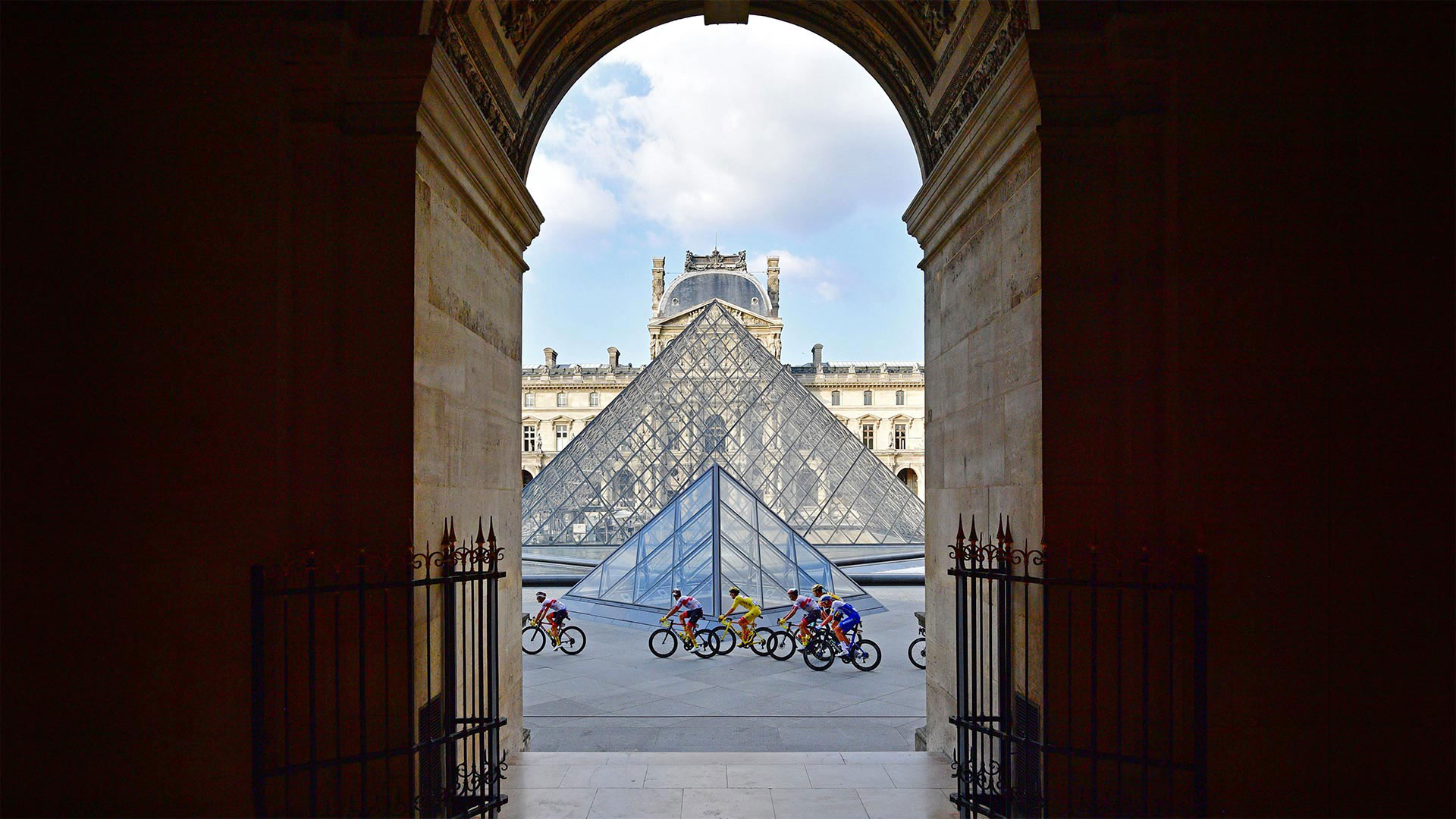
Tour de France riders in front of the Louvre Pyramid and museum in Paris, France, during the 2020 race (© Martin Bureau/AFP via Getty Images)
Tour de France riders in front of the Louvre Pyramid and museum in Paris, France, during the 2020 race (© Martin Bureau/AFP via Getty Images)
Grand finish of Le Tour
After a three-week jaunt around France, cycling's most prestigious race concludes today with a triumphant procession into Paris before a sprint finish on the iconic Champs-Élysées. The 21st and final stage of this year's Tour de France—the 108th edition of the famous event—begins in Chatou, a town in the western suburbs of Paris along the river Seine. Tour tradition dictates the overall race leader isn't challenged on the last day, so it starts out as a victory parade for the champion-elect, who will be wearing a yellow jersey, posing for pictures, and sipping a glass of champagne along the route. But when the riders reach the heart of Paris, the pace picks up as they dash around the Champs-Élysées, a tree-lined promenade often described as the 'most beautiful avenue in the world.'
The peleton—a large group of riders bunched together—enters the Champs-Élysées via the courtyards of the Louvre Palace, passing directly by its famous glass pyramid, as shown on our homepage. They then complete an eight-lap circuit, which takes them on a sightseeing tour around the Arc de Triomphe, past the Tuileries Garden, across the Place de la Concorde—the largest square in Paris—and back up the cobblestones of the Champs-Élysées, which is French for 'Elysian Fields,' the final resting place for heroes from Greek mythology. Quite the place then to finish a relentless race that covers more than 2,000 miles and includes brutal climbs in the Alps and the Pyrenees. Chapeau!
乐游大结局
经过为期三周的环法之旅,这场最负盛名的自行车赛今天以胜利的游行队伍结束,进入巴黎,然后在标志性的Champs-Élysées进行冲刺。第108届环法自行车赛是今年环法自行车赛的第21个也是最后一个阶段,在巴黎西郊塞纳河沿岸的一个小镇Chatou举行。巡回赛的传统规定,总的领队在最后一天不会受到挑战,所以这是冠军当选人的胜利游行,他将穿着黄色球衣,摆姿势拍照,沿途啜饮一杯香槟。但当骑手们到达巴黎市中心时,他们在香榭丽舍大道(Champs-Élysées)周围奔跑时,步伐加快了,这是一条绿树成荫的长廊,常被称为“世界上最美丽的大道”
佩尔顿——一大群骑手聚集在一起,通过卢浮宫的庭院进入香榭丽舍,直接经过著名的玻璃金字塔,如我们的主页所示。然后,他们完成了一个八圈的线路,带着他们游览凯旋门,经过杜伊勒里花园,穿过巴黎最大的广场协和广场(Place de la Concorde),回到香榭丽舍(Champs-Élysées)的鹅卵石上,香榭丽舍是“极乐世界”(Elysian Fields)的法语意思,这是希腊神话中英雄们的最后安息之地。这是一个很好的地方来完成一个无情的比赛,覆盖了2000多英里,包括在阿尔卑斯山和比利牛斯山残酷的攀登。起首!
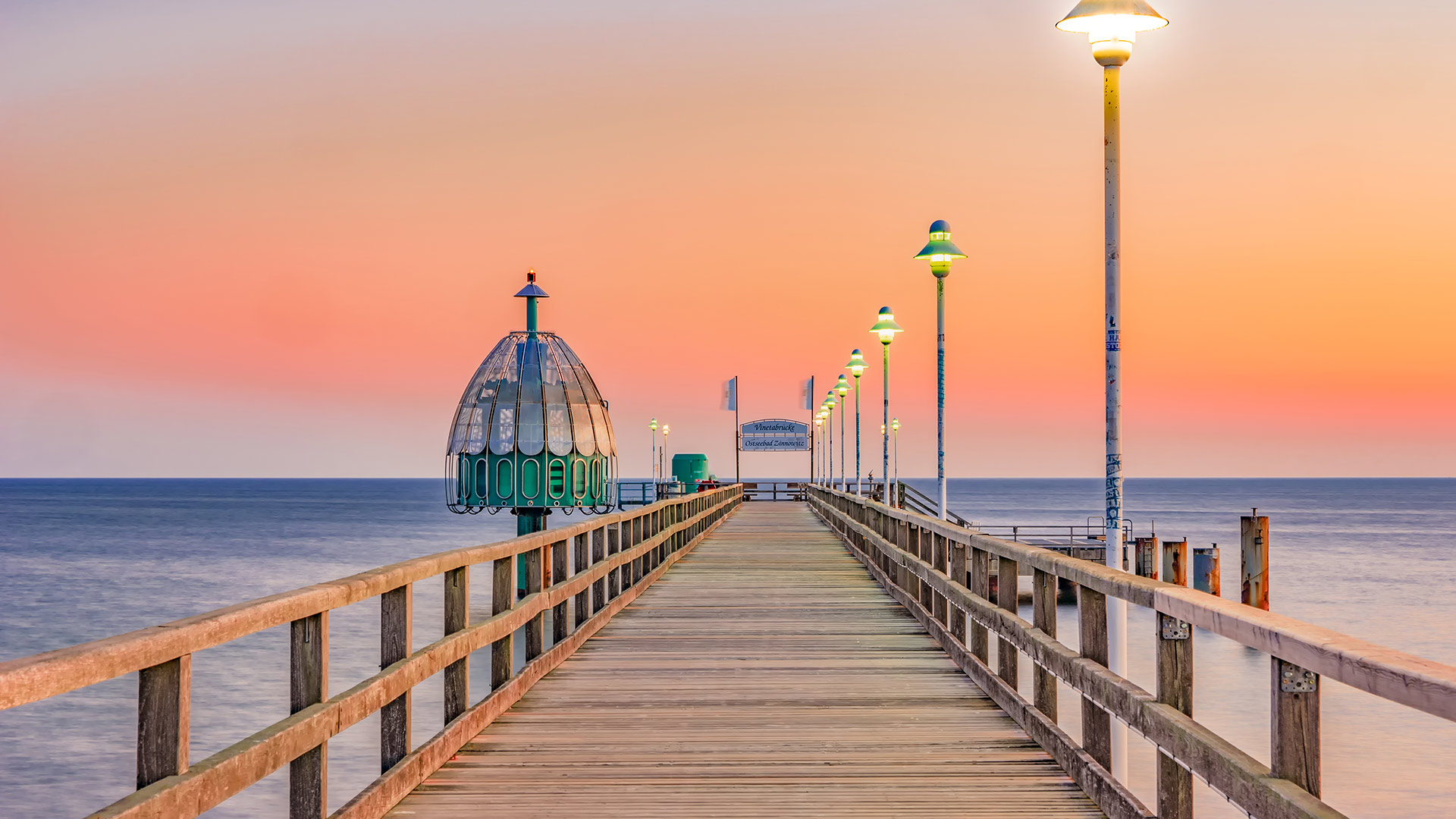
Zinnowitz pier on Usedom island in the Baltic Sea, Germany (© Frank Günther/Getty Images)
Zinnowitz pier on Usedom island in the Baltic Sea, Germany (© Frank Günther/Getty Images)
蒙舒瓦西海滩,毛里求斯 Mont Choisy Beach, Mauritius (© Robert Harding World Imagery/Offset by Shutterstock)
蒙舒瓦西海滩,毛里求斯 Mont Choisy Beach, Mauritius (© Robert Harding World Imagery/Offset by Shutterstock)
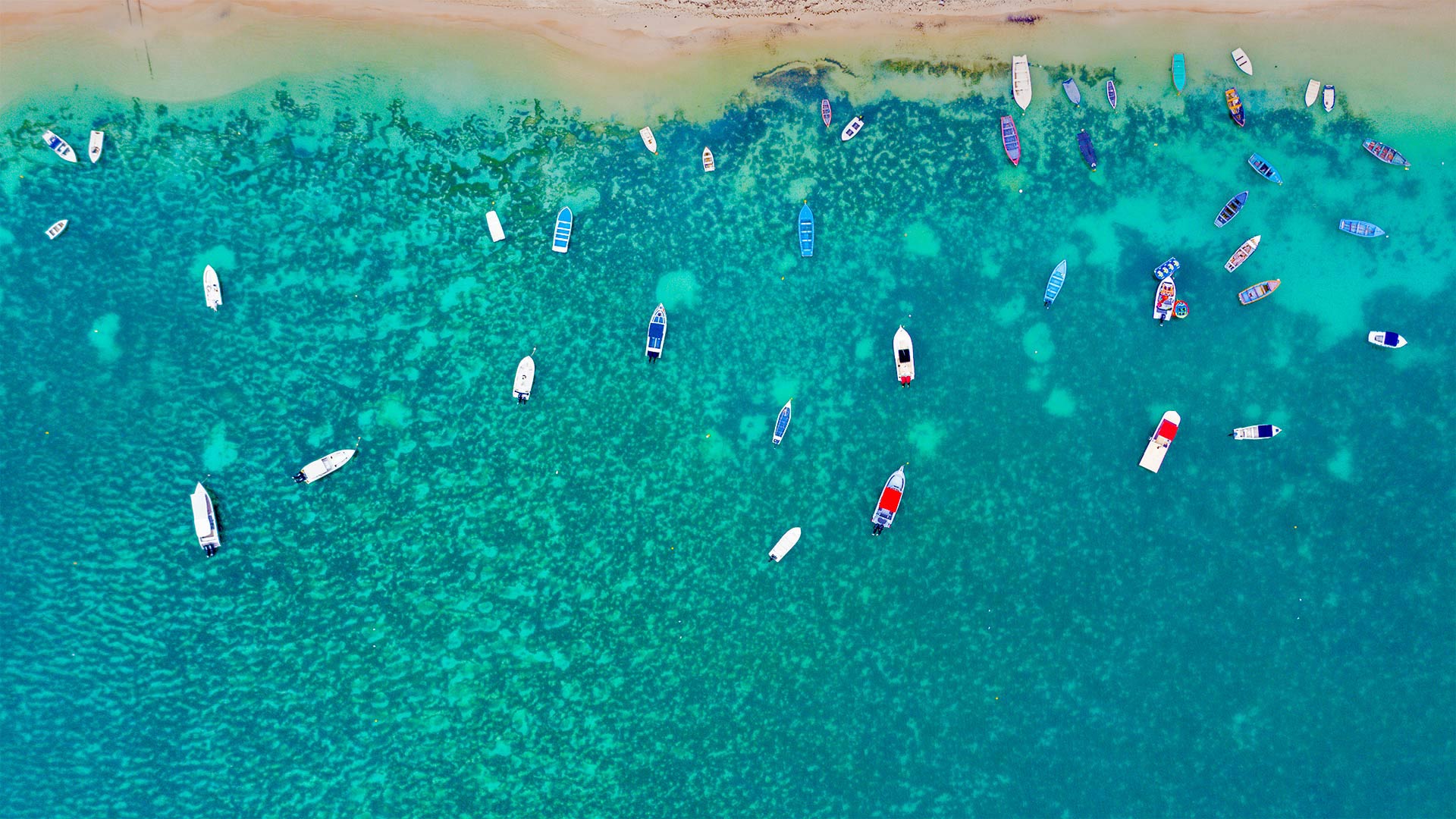
Whatever floats your boat
These turquoise waters are lapping the sands of Mont Choisy Beach in Mauritius, an island nation off the southeastern coast of Africa. It's a popular spot for locals and tourists to swim, enjoy the sun, or head out in one of these boats to catch some fish. The island has a unique cultural history. Most scholars believe it was known to Arab seafarers by the 10th century but it remained uninhabited until Portuguese sailors established a base on the island in the early 1500s. Mauritius was later colonized in succession by the Netherlands, France, and Great Britain before gaining independence in 1968. Over the years, Mauritius has evolved from a low-income economy based mostly on sugarcane (still one of its biggest exports), to a more diverse one that includes tourism, clothing production, and technology.
随心所欲
这些绿松石色的海水拍打着非洲东南海岸岛国毛里求斯的蒙崔西海滩的沙滩。对于当地人和游客来说,这是一个很受欢迎的地方,他们可以游泳,享受阳光,或者乘坐这些船去钓鱼。这个岛有着独特的文化历史。大多数学者认为,阿拉伯海员在10世纪就知道了这座岛屿,但直到15世纪初葡萄牙水手在岛上建立了基地,它才被发现。后来,毛里求斯先后被荷兰、法国和英国殖民统治,1968年获得独立。多年来,毛里求斯已从一个以甘蔗为主的低收入经济体(仍然是其最大的出口产品之一)发展成为一个更加多样化的经济体,包括旅游业、服装生产和技术。
Ngo Dong河两岸的稻田美景,越南宁平省 Boats float by rice fields on the Ngo Dong River in Ninh Binh province, Vietnam (© Jeremy Woodhouse/Getty Images)
Ngo Dong河两岸的稻田美景,越南宁平省 Boats float by rice fields on the Ngo Dong River in Ninh Binh province, Vietnam (© Jeremy Woodhouse/Getty Images)
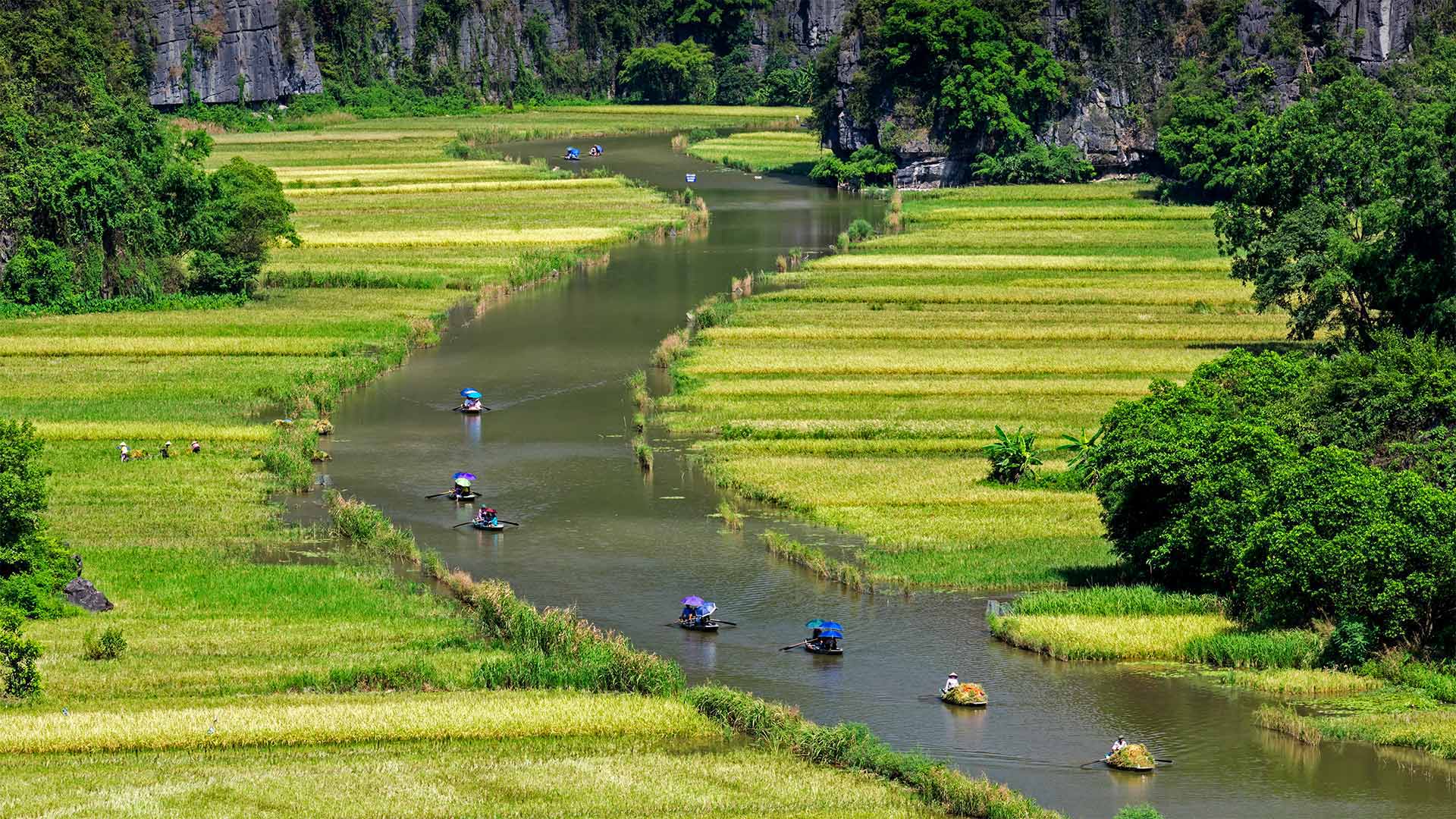
A river runs through rice fields
We're peering down the winding Ngo Dong River at a group of rowboats meandering through rice paddy fields. This is the Ninh Binh province in Vietnam, about 60 miles south of Hanoi. On these two-hour tours by traditional Vietnamese rowboat, visitors wend their way between limestone karst peaks, through grottoes, and, if they're lucky, by workers harvesting rice in the fields, their wide-brimmed hats shielding them from the sun. Perhaps the most spectacular time to take this river cruise is around harvest time in late May and early June when the paddy fields are awash in a golden glow with a backdrop of bright green hillsides. But don't be surprised if the person rowing your boat moves the oars from hands to feet. It's tradition here for rowers to take a break and let their legs take over.
一条河穿过稻田
我们在蜿蜒的鄂东河上眺望,一群划艇蜿蜒穿过稻田。这是越南的宁平省,在河内以南大约60英里。在这两个小时的传统越南划艇之旅中,游客们穿梭于石灰岩喀斯特山峰之间,穿过石窟,如果幸运的话,还可以乘坐工人们在田里收割稻谷,他们戴着宽边帽遮挡阳光。也许最壮观的时候,采取这条河游轮是在丰收的时候,在5月底和6月初,当稻田淹没在一个金光闪闪的背景下明亮的绿色山坡。但是如果划船的人把桨从手移到脚,也不要感到惊讶。这里的传统是让划船者休息一下,让他们的腿来代替。
大溪地海岸附近的乌翅真鲨,法属波利尼西亚 Blacktip reef sharks off the coast of Tahiti, French Polynesia (© Paul Mckenzie/Minden Pictures)
大溪地海岸附近的乌翅真鲨,法属波利尼西亚 Blacktip reef sharks off the coast of Tahiti, French Polynesia (© Paul Mckenzie/Minden Pictures)
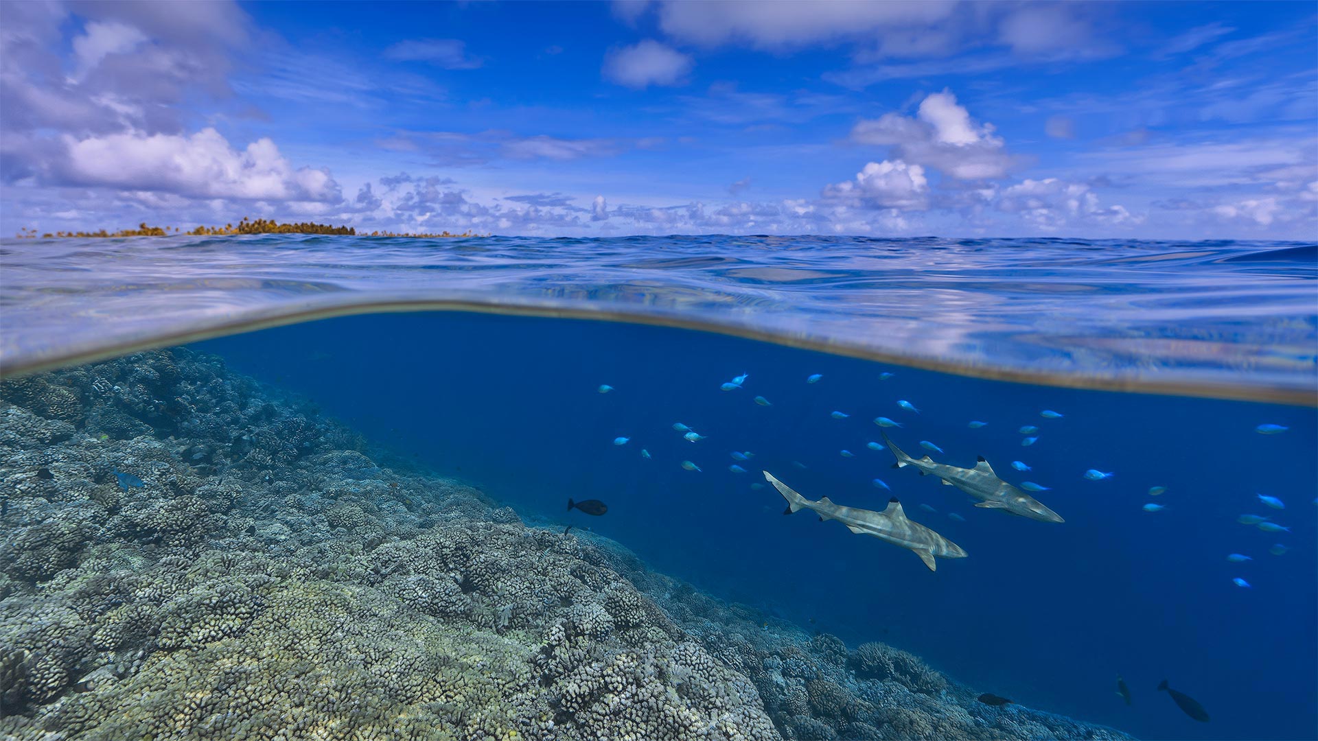
A different view of sharks
They've long been treated as threats, portrayed as villains, and brutally hunted for their edible fins, so we think it's only fair that sharks get their own day. Shark Awareness Day is meant to highlight the importance of the most fearsome fish in nature, from little lanternsharks to great whites to these blacktip reef sharks cruising the Tahitian coast.
Why celebrate an apex predator that most humans associate with horror movies? Well, first: The blacktip reef shark is timid around people and has never fatally attacked a human. And second: Without sharks acting as population control on other marine life, the ocean would be a very different place. Sharks eat a lot of squid and smaller fish, and like land predators, help keep their prey from overpopulating. Shark populations have declined more than 70% since the 1970s, so they deserve our attention as a vital, disappearing part of the marine ecosystem—even if they seem a little scary.
对鲨鱼的不同看法
它们长期以来被视为威胁,被描绘成恶棍,被残忍地猎杀以获取可食用的鱼鳍,所以我们认为鲨鱼有自己的一天是公平的。鲨鱼意识日旨在强调自然界中最可怕的鱼类的重要性,从小灯笼鲨到大白鲨,再到这些在塔希提海岸游弋的黑尖礁鲨。
为什么要庆祝一个大多数人与恐怖电影联系在一起的顶级捕食者?首先,黑尖礁鲨对人很胆小,从来没有致命地攻击过人类。第二:没有鲨鱼作为其他海洋生物的种群控制,海洋将是一个完全不同的地方。大量的鱼类,像乌贼一样,帮助它们捕食陆地上的小鱼。自上世纪70年代以来,鲨鱼的数量已经减少了70%以上,因此,作为海洋生态系统中一个重要的、正在消失的部分,鲨鱼值得我们关注,即使它们看起来有点可怕。
驼鹿穿过莫兰山下的池塘,怀俄明州大提顿国家公园 Moose crossing a pond below Mount Moran, Grand Teton National Park, Wyoming (© Jim Stamates/Minden Pictures)
驼鹿穿过莫兰山下的池塘,怀俄明州大提顿国家公园 Moose crossing a pond below Mount Moran, Grand Teton National Park, Wyoming (© Jim Stamates/Minden Pictures)
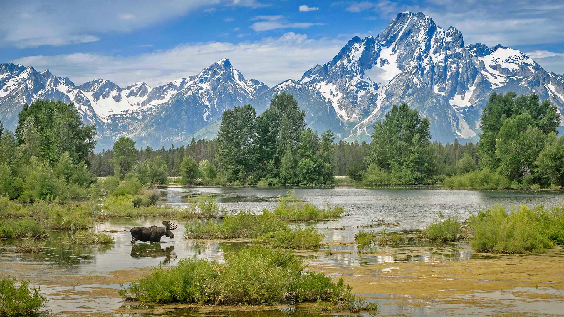
Through an artist's eyes
If this beautiful view of Grand Teton National Park seems as pretty as a painting, there may be a reason for it. That majestic peak towering over the landscape is Mount Moran, named for Thomas Moran, an American artist of New York's Hudson River School who earned fame by painting scenes of the western frontier. In 1871, Moran and photographer William Henry Jackson were invited on an expedition to the Yellowstone region to accompany a team from the US Geological Society while they conducted the first comprehensive survey of the area. Moran's paintings and Jackson's photographs from the trip immediately captured the public's attention and inspired Congress to establish Yellowstone as the first national park in 1872.
For the next two decades, Moran painted hundreds of landscapes of the Yellowstone region, producing indelible images of this spectacular wilderness that would come to define the American West in the imaginations of many. The area had such an impact on Moran that he adopted the signature T-Y-M, Thomas 'Yellowstone' Moran. He returned to the area in August 1879 on an expedition to the Teton range, just south of Yellowstone National Park. He never made it as far into the mountains as he'd hoped, but gazing up at the towering peaks, he wrote in his diary, 'From this point it is perhaps the finest pictorial range in the United States or even N. America.' Judging from this image, it's hard to argue with him.
透过艺术家的眼睛
如果大提顿国家公园的美景看起来像一幅画一样美丽,那可能是有原因的。这座巍峨的山峰是摩兰山,以纽约哈德逊河学校的美国艺术家托马斯·莫兰的名字命名,他以画西部边疆而闻名。1871年,莫兰和摄影师威廉·亨利·杰克逊应邀到黄石地区探险,陪同美国地质学会的一个小组对该地区进行第一次全面调查。莫兰的画作和杰克逊旅行中的照片立即引起了公众的注意,并在1872年激励国会将黄石公园建成第一个国家公园。
在接下来的20年里,莫兰绘制了黄石地区的数百幅风景画,为这片壮观的荒野绘制了不可磨灭的图像,这些图像将在许多人的想象中成为美国西部的定义。这个地区对莫兰的影响如此之大,以至于他采用了标志性的T-Y-M,托马斯“黄石”莫兰。他于1879年8月返回该地区,前往黄石国家公园以南的提顿山脉探险。他从来没有像他所希望的那样深入山区,但他在日记中写道,仰望巍峨的山峰,从这一点上看,它可能是美国乃至北美最好的画作。从这个形象来看,很难和他争辩。
海浪撞击费尔盖拉什灯塔,葡萄牙波尔图 Wave crashing on Farolim de Felgueiras, a lighthouse in Porto, Portugal (© Stephan Zirwes/Offset by Shutterstock)
海浪撞击费尔盖拉什灯塔,葡萄牙波尔图 Wave crashing on Farolim de Felgueiras, a lighthouse in Porto, Portugal (© Stephan Zirwes/Offset by Shutterstock)
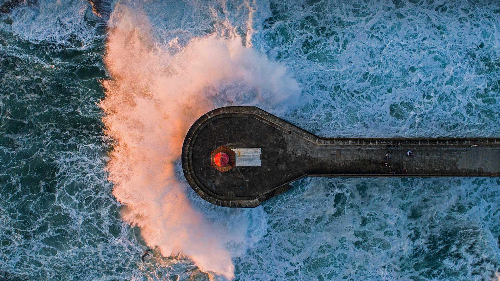
A lofty lighthouse and a little ocean spray
The Farolim de Felgueiras (Lighthouse of Felgueiras) you see here has withstood relentless waves for around 135 years. It offered its solitary warnings to ships approaching Porto, Portugal's second-largest city, beginning in 1886 until it was finally deactivated in 2009. Even though it's no longer operational, it's still a well-known local landmark. It offers sightseers a beautiful view, and maybe a little ocean spray, from its perch overlooking the mouth of the Douro river where it flows into the Atlantic.
The nearby city of Porto was originally established in around 136 BCE by the Romans as an outpost called Portus Cale, which is believed to be the origin of the name Portugal. The city is also responsible for the name of one of the country's most famous exports, Port wine, the (usually) sweet red fortified wine that was first exported by local merchants across Europe in the second half of the 17th century. These days the city and surrounding municipalities are home to around 1.7 million people, but Porto retains its historic charm. One of its oldest riverside neighborhoods, the Ribeira, was honored as a World Heritage Site by UNESCO in 1996 and was also designated as a National Monument of Portugal.
一座高耸的灯塔和一点浪花
你在这里看到的费尔盖拉灯塔(Farolim de Felgueiras)经受了大约135年无情的海浪。它从1886年开始向接近葡萄牙第二大城市波尔图的船只发出单独警告,直到2009年最后关闭。尽管它已经停止运作,但它仍然是当地著名的地标。它为观光客提供了一个美丽的景色,也许还有一点海洋浪花,从它的栖息处俯瞰着杜罗河口,杜罗河口流入大西洋。
附近的城市波尔图最初由罗马人在公元前136年左右建立,作为一个前哨站,称为波尔图卡尔,这被认为是葡萄牙这个名字的起源。这座城市也是该国最著名的出口商品之一,波尔图葡萄酒(Port wine)的名字的来源,波尔图葡萄酒(Port wine)是一种(通常)甜红色的强化葡萄酒,17世纪后半叶,当地商人首次在欧洲各地出口。如今,这座城市和周围的市政当局居住着大约170万人,但波尔图仍然保持着它的历史魅力。里贝拉是最古老的河畔社区之一,1996年被联合国教科文组织列为世界遗产,并被指定为葡萄牙国家纪念碑。
塔霍河上空的银河,西班牙蒙弗拉圭国家公园 Milky Way over the Tagus river in Monfragüe National Park, Spain (© Miguel Angel Muñoz Ruiz/Cavan Images)
塔霍河上空的银河,西班牙蒙弗拉圭国家公园 Milky Way over the Tagus river in Monfragüe National Park, Spain (© Miguel Angel Muñoz Ruiz/Cavan Images)
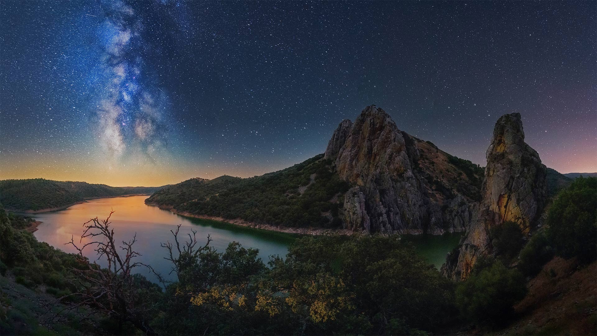
Celestial Spain
Today we're in the Extremadura region of western Spain, in the beautiful Monfragüe National Park along the border with Portugal. This 18-mile long, 4-mile wide stretch of nature in the province of Cáceres is framed by the Tagus and Tietar rivers (it's the Tagus that's in our image today). The mountainous Pena Falcon rock face defines its western side. Much of the park is covered by a thick Mediterranean forest full of wildlife, making this place a destination for outdoor lovers of all sorts. It's especially notable for the many birds: Over 280 species that are found here, including storks, kingfishers, cormorants, and eagles, as well as one of the world's largest reserves of black vultures and their tawny vulture cousins. Other wildlife routinely spotted in Monfragüe include otters, deer, wild boar, and Iberian lynx.
When the sun goes down in Monfragüe, the generally cloudless sky, combined with the low level of light pollution makes this a perfect place for stargazing. The national park was recognized as a dark-sky preserve in 2016. Monfragüe also appeals to those interested in the human history of the area, as it contains a number of caves with prehistoric paintings, Roman ruins, and the remnants of the castle of Monfragüe, which was built by Moors in the 9th century.
天国西班牙
今天我们来到西班牙西部的埃斯特马杜拉地区,在与葡萄牙接壤的美丽的蒙弗雷盖国家公园。这片18英里长、4英里宽的自然景观位于卡塞雷斯省,被塔格斯河和蒂塔尔河(我们今天的图像中就是塔格斯河)所环绕。多山的佩纳猎鹰岩面界定了它的西侧。公园的大部分被一片茂密的地中海森林所覆盖,森林里到处都是野生动物,这使这里成为各种户外爱好者的目的地。尤其值得注意的是,这里有280多种鸟类,包括鹳、翠鸟、鸬鹚和老鹰,以及世界上最大的黑秃鹫及其黄褐色秃鹫近亲保护区之一。其他经常在蒙弗雷盖发现的野生动物包括水獭、鹿、野猪和伊比利亚猞猁。
当太阳在蒙弗雷盖落山时,通常无云的天空,加上低水平的光污染,使这里成为一个完美的地方凝视星空。2016年,国家公园被认为是一个黑暗的天空保护区。蒙弗拉圭也吸引了那些对该地区的人类历史感兴趣的人,因为它包含了一些带有史前绘画的洞穴、罗马遗迹和蒙弗拉圭城堡的遗迹,蒙弗拉圭城堡是摩尔人在9世纪建造的。
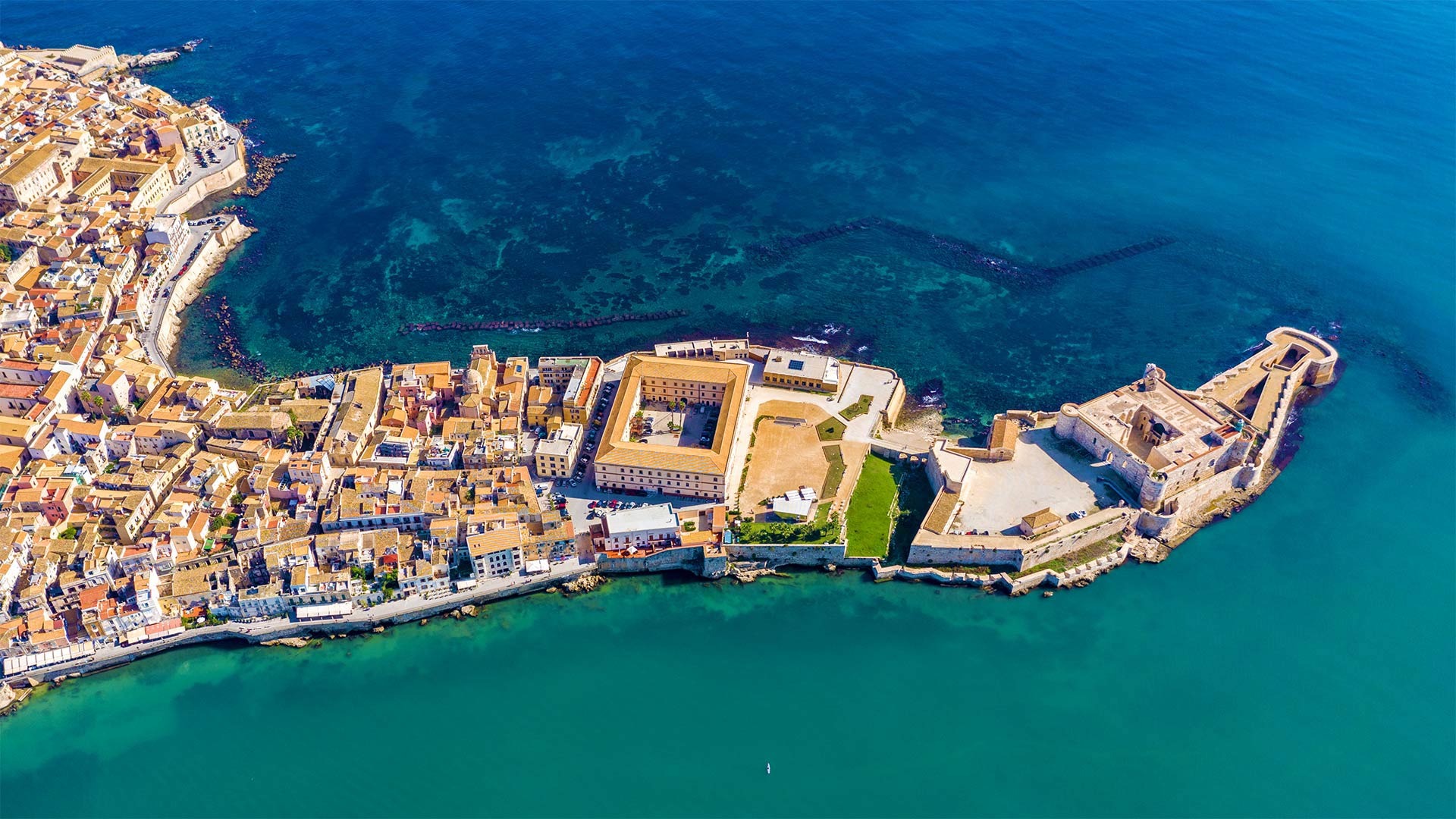
奥提伽,西西里岛锡拉库萨海岸附近的小岛,意大利 Ortygia, a small island off the coast of Syracuse, Sicily, Italy (© DaLiu/Shutterstock)
奥提伽,西西里岛锡拉库萨海岸附近的小岛,意大利 Ortygia, a small island off the coast of Syracuse, Sicily, Italy (© DaLiu/Shutterstock)
A center of antiquity on the Mediterranean
This bird's-eye view lets us take in the charms of Ortygia, a small island just offshore from Syracuse, on Sicily's east coast. Ortygia is considered Syracuse's 'old town' and the historical heart of the city. A narrow channel separates the island from Syracuse and two bridges connect Ortygia to mainland Sicily. Ancient Greeks first colonized this island in the 8th century BCE, and the town is brimming with 2,700 years of history. Walk Ortygia's web of narrow streets and you'll see Greek and Roman ruins, medieval Norman buildings, and examples of Baroque architecture as well.
A Homeric texts Hymn tells of claim the goddess Leto, who stopped at Ortygia to give birth to her twins, Artemis and Apollo. Visitors today can pay homage to the mythology with a visit to the Temple of Apollo, which dates from the 6th century BCE, making it the oldest Doric temple in Sicily. But for some, the most magnificent attraction to Ortygia is the cerulean Mediterranean Sea, which surrounds the island in a shimmery blue.
地中海上的古代中心
这张鸟瞰图让我们领略了奥蒂吉亚的魅力,奥蒂吉亚是西西里岛东海岸锡拉丘兹附近的一个小岛。奥蒂吉亚被认为是锡拉丘兹的“老城”和城市的历史中心。一条狭窄的水道将该岛与锡拉丘兹分隔开来,两座桥将奥尔蒂加岛与西西里岛大陆连接起来。古希腊人在公元前8世纪首次在这个岛上建立殖民地,这个城镇有2700年的历史。走在奥尔蒂加狭窄的街道网,你会看到希腊和罗马遗迹,中世纪的诺曼建筑,以及巴洛克建筑的例子。
荷马经文的一首赞美诗讲述了女神勒托的主张,她在奥蒂吉亚停下来生下了她的双胞胎,阿耳特弥斯和阿波罗。今天的游客可以通过参观阿波罗神庙来向神话致敬,阿波罗神庙可以追溯到公元前6世纪,是西西里岛最古老的多立克神庙。但对一些人来说,奥蒂吉亚最吸引人的地方是蔚蓝的地中海,它以闪烁的蓝色环绕着奥蒂吉亚岛。
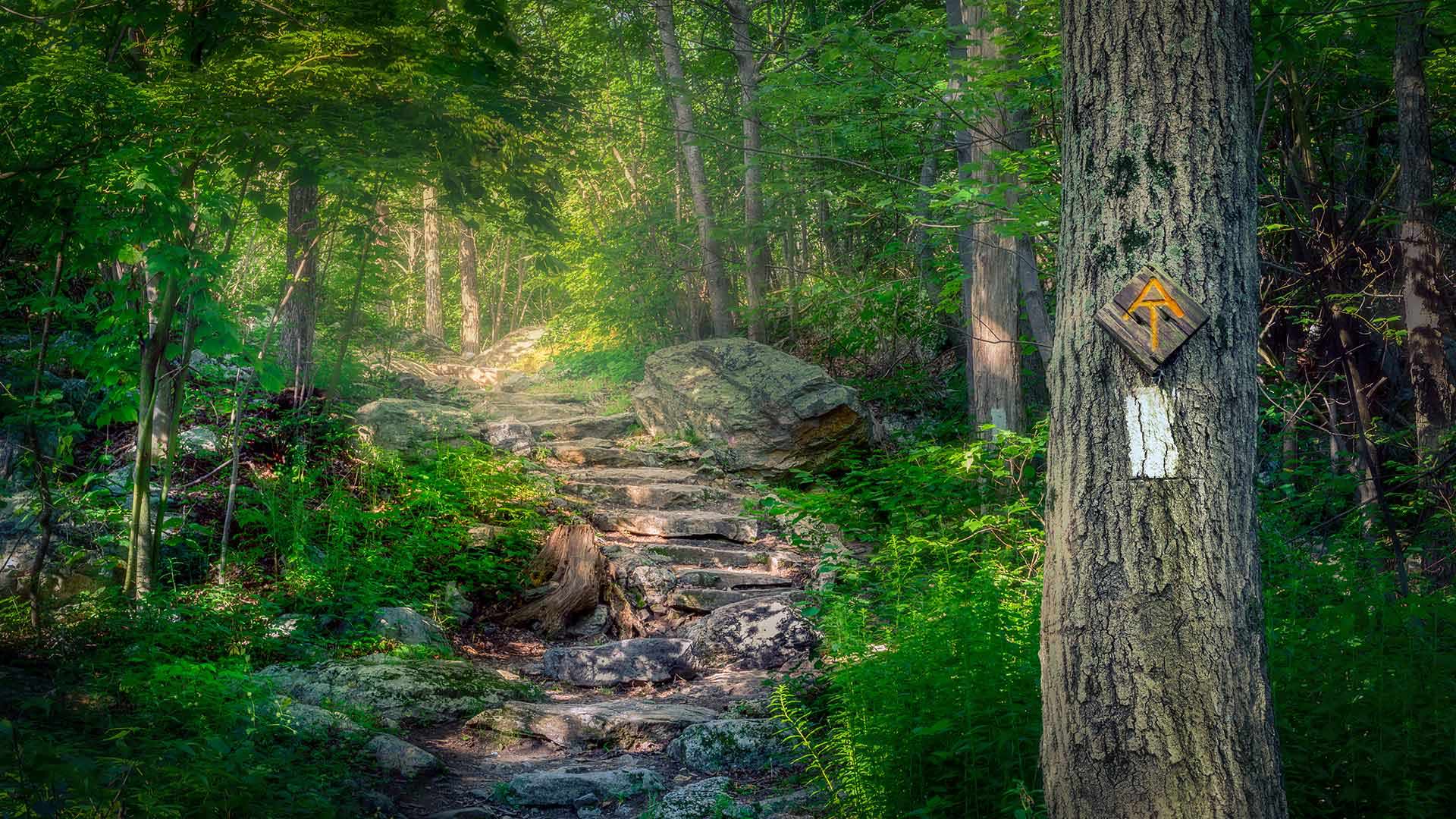
阿巴拉契亚国家步道,新泽西州斯托克斯州立森林 The Appalachian Trail in Stokes State Forest, New Jersey (© Frank DeBonis/Getty Images)
阿巴拉契亚国家步道,新泽西州斯托克斯州立森林 The Appalachian Trail in Stokes State Forest, New Jersey (© Frank DeBonis/Getty Images)
A storied trail marks a century
This is but a tiny portion of what's often called the longest hiking-only trail in the world. Today we're in Stokes State Forest along the top edge of New Jersey and those tell-tale two-by-six-inch white blazes tell us that we're on the famous Appalachian Trail (the 'AT' to those in the know). And what a day to be here, for July 8, 2021, is the trail's 100th birthday.
It was 100 years ago today that the trail was first conceived by a Connecticut forester named Benton MacKaye. MacKaye wanted to connect a series of farms and wilderness study camps across many states, and he liked the idea that the trail would be accessible to many via the towns and roads it would pass by. After more than a decade of work, the AT was completed in 1937 and currently stretches 2,190 miles (give or take a few) from Georgia to Maine and 12 states in between. Today we raise a birthday toast to 100 years of hiking and the millions of people from all over the world who have trekked at least a portion of these trails. Cheers!
一条传说中的小径标志着一个世纪
这只是世界上最长的徒步旅行路线的一小部分。今天,我们来到了位于新泽西州顶端边缘的斯托克斯州立森林,那些2×6英寸的白色火焰告诉我们,我们在著名的阿巴拉契亚小径上(对知情者来说是“AT”)。2021年7月8日是小径的100岁生日,这是多么美好的一天啊。
100年前的今天,康涅狄格州一位名叫本顿·麦凯的森林学家首次构思了这条小径。麦凯想把许多州的一系列农场和荒野研究营地连接起来,他喜欢这样的想法,即这条小径可以通过它经过的城镇和道路让很多人都能到达。经过十多年的努力,AT于1937年完工,目前从乔治亚州到缅因州以及其间的12个州绵延2190英里(大概几英里)。今天,我们为100年的徒步旅行和来自世界各地的数百万人举杯祝酒,他们至少跋涉过这些小径的一部分。干杯!