被胡杨树围绕着的湖, 金塔县, 酒泉, 甘肃, 中国 Lake surrounded by euphrates poplar trees, Jinta, Jiuquan, Gansu, China (© Feng Wei Photography/Getty images)
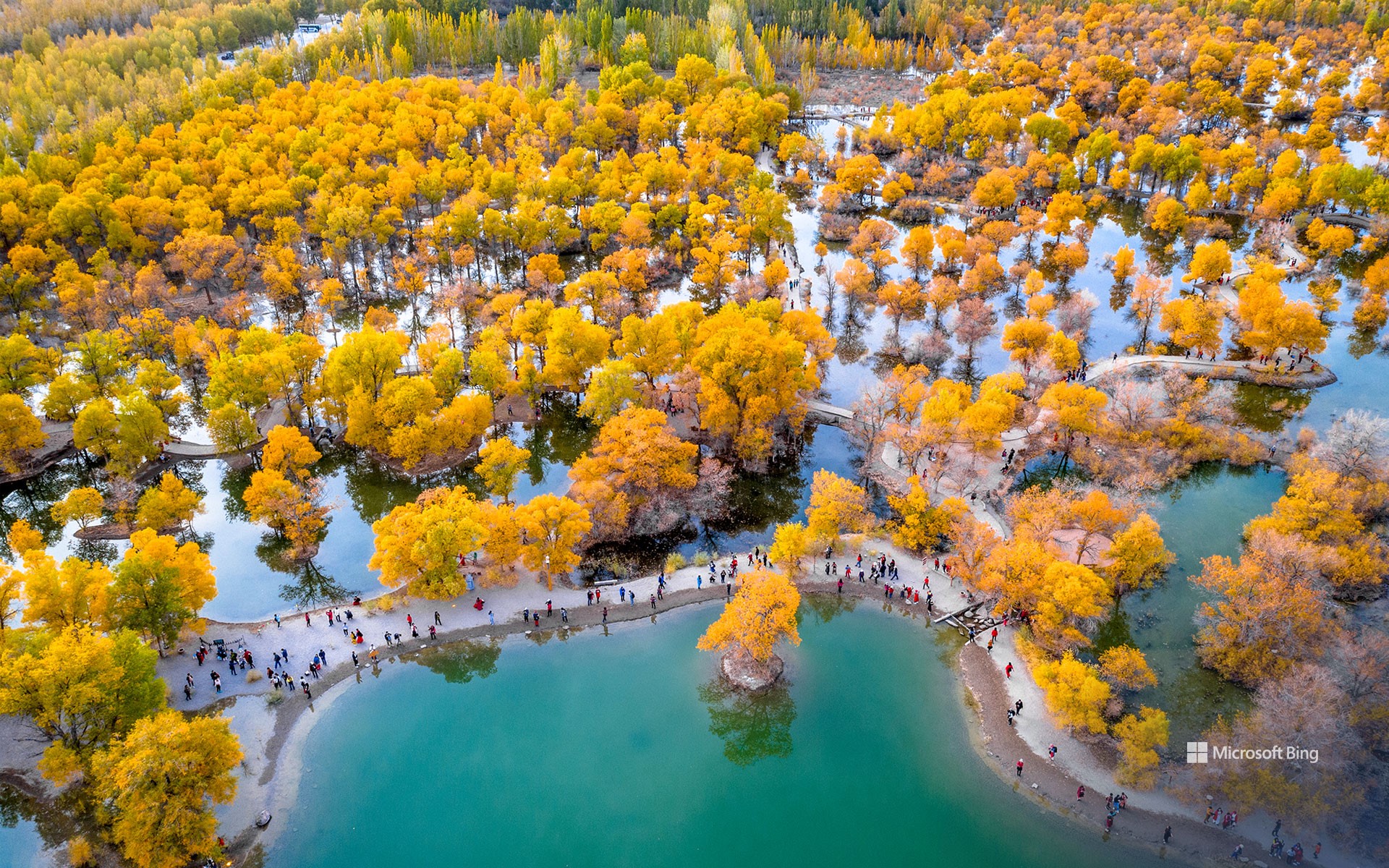
被胡杨树围绕着的湖, 金塔县, 酒泉, 甘肃, 中国 Lake surrounded by euphrates poplar trees, Jinta, Jiuquan, Gansu, China (© Feng Wei Photography/Getty images)
千年秘境 Thousand Years of Secret Realm
中国甘肃金塔胡杨林
金塔沙漠胡杨林风景区位于甘肃省酒泉市金塔县西部巢湖林场,占地八万余亩,拥有西北地区最大的人工胡杨林。这些古老、耐寒耐旱的胡杨树,是第三纪遗留下来的,创造了“三千年古树”的生态奇观。金波湖水与胡杨林相映成趣,沙枣、柽柳等植物构成了多样的生态系统。
马蒂莫阿帕沼泽保护区泥炭地鸟瞰图, 芬兰 Aerial view of peatland in Martimoaapa Mire Reserve, Finland (© romikatarina/Shutterstock)
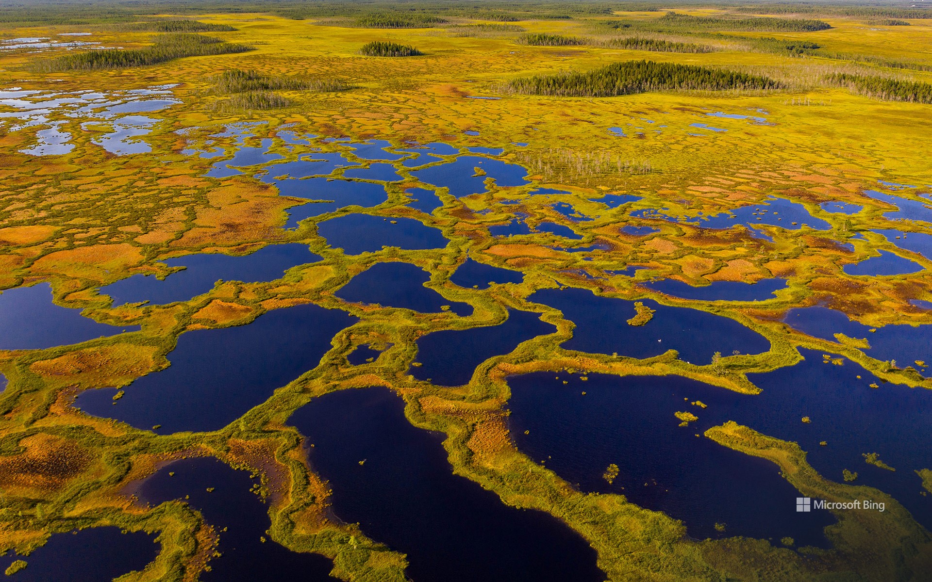
马蒂莫阿帕沼泽保护区泥炭地鸟瞰图, 芬兰 Aerial view of peatland in Martimoaapa Mire Reserve, Finland (© romikatarina/Shutterstock)
芬兰的活泥炭地 Finland's living peatland
马蒂莫阿帕沼泽保护区,芬兰
芬兰的沼泽大多是由泥炭地组成,它们源自大约 12,000 年前上一个冰河时期结束后,沉积物与苔藓不断堆积、分解而成。
这仅仅是个开始。考古学家在这里发现了曾用来储存肉类的半咸水坑,以及一个约33英尺宽的神秘石圈——仿佛源自北方神话。它的用途?至今仍是谜。更近代的历史则留存在萨乌纳萨里桑拿屋中,它曾是伐木工小屋的一部分,为在这片北方森林中劳作的男人们提供温暖、休息,以及烘干身体的地方。
在这里野生动物随处可见,为这片土地增添了生机。近百种鸟类在此筑巢,从天鹅、鹤到猫头鹰和红隼。保护区内设有多条长短不一的步道,长度从 1.9 英里到 8 英里不等,沿途散布着小屋与篝火点,邀请人们夏日徒步探索,或在冬季滑雪穿行。
Martimoaapa Mire Reserve, Finland
Today, we step into the Martimoaapa Mire Reserve in Finland, where wide, cold-climate wetlands and peatlands stretch across a landscape shaped over thousands of years. This reserve is more than just mires—it carries layers of history. During Finland's Prohibition era (1919–1932), smugglers hauled sacks of liquor from Sweden across these bogs, following a 'spirits' route that passed through Martimoaapa. Parts of that path can still be traced today. Imagine trekking with a heavy pack over soggy ground—would you have made it?
This is just the beginning. Here, archaeologists have discovered brackish pits once used to store meat, and a mysterious stone circle about 33 feet wide—like something out of a northern myth. Its purpose? Still unknown. More recent history lives on in the Saunasaari sauna, once part of a logging cabin built for men who worked these boreal forests. It gave them warmth, rest, and a place to dry off.
Wildlife, ever-present, completes the picture. Nearly 100 bird species nest here, from swans and cranes to owls and kestrels. Trails ranging from 1.9 to 8 miles, dotted with huts and campfire sites, invite you to explore—on foot or on skis in winter.
玛丽皇后号邮轮的夜景, 长滩, 加利福尼亚州, 美国 Night view of the RMS Queen Mary, Long Beach, California (© Kit Leong/Shutterstock)

玛丽皇后号邮轮的夜景, 长滩, 加利福尼亚州, 美国 Night view of the RMS Queen Mary, Long Beach, California (© Kit Leong/Shutterstock)
从“灰色幽灵”到幽灵传说 From 'Grey Ghost' to ghost stories
玛丽皇后号邮轮的夜景, 长滩, 加利福尼亚州
她注定不会被遗忘。1936年,“玛丽女王号” 首次横渡大西洋时,便夺尽风采。这艘装饰艺术风格的巨轮打破了航速纪录,承载过无数名流、皇室成员与政要。二战期间,她的身份从“海上宫殿”骤然转变为“灰色幽灵”,奢华尽数褪去,取而代之的是装载盟军部队的使命。1967年,航行30年后,她退役停泊在加州长滩。如今,她的甲板化身为酒店走廊、导览展区,成为一座活生生的海事历史纪念碑。
但她的传说并未随锚链一同沉寂。多年来,游客与船员都声称曾在空荡的走廊里听到回声,在金属甲板上听见脚步回荡,甚至在荒废的泳池边传来孩童的笑声。如今的“鬼魂之旅”常常以这些诡异故事为卖点,但历史学家指出,船上所有死亡事件均因自然原因,从未有过谋杀记录。今天的“玛丽女王号”既是历史的地标,也是传说的舞台。那么,她真的闹鬼吗?没有任何档案能够证实,但那些低语般的传闻,依旧让她的故事历久弥新。
Night view of the RMS Queen Mary, Long Beach, California
She was never meant to fade away. When the RMS Queen Mary sailed in 1936, she stole the spotlight across the Atlantic—an Art Deco liner that broke speed records and carried celebrities, royalty, and dignitaries. War transformed her from a floating palace into the 'Grey Ghost,' stripped of luxury and loaded with Allied troops. In 1967, after 30 years at sea, she retired to Long Beach, where her decks now serve as hotel corridors, guided exhibits, and a living monument to maritime history.
But her legend did not dock with her anchors. Over the years, guests and crew have spoken of echoes in empty corridors, footsteps reverberating on metal floors, and the laughter of a child near the deserted pool. Ghost tours highlight these eerie stories, though historians note that deaths aboard were due to natural causes, with no murders ever recorded. Today, the Queen Mary stands as both a heritage landmark and a stage for folklore. So, is she haunted? There are no records confirming it, yet the whispers keep her stories very much alive.
贝洛格拉齐克石林,保加利亚 Belogradchik Rocks, Bulgaria (© EvaL Miko/Shutterstock)
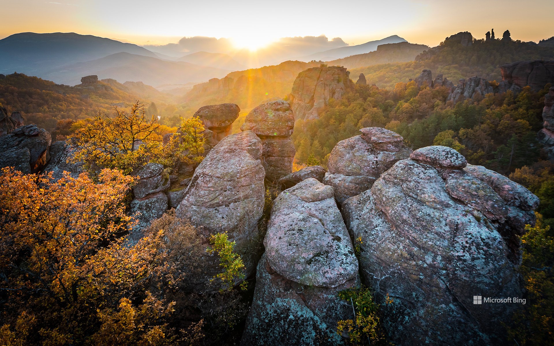
贝洛格拉齐克石林,保加利亚 Belogradchik Rocks, Bulgaria (© EvaL Miko/Shutterstock)
刻在石头上 Set in stone
贝洛格拉齐克石林,保加利亚
在保加利亚巴尔干山脉西麓,贝洛格拉奇克石林如同一座天然画廊,每一块岩石都诉说着独特的故事。这些砂岩与石灰岩柱经过数百万年的风化与侵蚀,形成了千姿百态的奇特造型,当地人坚信其中有些轮廓酷似人物、动物,甚至完整的场景。因此,这些岩石也被赋予了富有想象力的名字,如"骑手岩"、"女学生岩"、"僧侣岩"等。在这片土地上,辨认岩石形状就像在玩一场大自然版的猜谜游戏,既有趣又充满惊喜。
这些岩石如今已被列入联合国教科文组织的世界遗产预备名单,绵延超过18英里,环绕着贝洛格拉奇克小镇。它们的色彩会随着光线变化,从深红到金黄,宛如一幅动态的自然画卷。历史也曾赋予它们实际用途——贝洛格拉奇克堡垒就是最好的例证。这座堡垒最早由罗马人修建,后来又被奥斯曼人加固,其结构巧妙地依托岩石作为天然屏障。毕竟,当山体已经筑起坚固防线,又何须再费力建墙?如今,游客们来到这里徒步、攀岩、拍照,探索那些奇形怪状的岩石。但他们往往带走的不只是照片,更是故事。贝洛格拉奇克石林不仅是地质构造,更是凝固在石头中的传说。
The Belogradchik Rocks in Bulgaria
In Bulgaria, on the western slopes of the Balkan Mountains, the Belogradchik Rocks stand like a natural gallery where every formation tells a tale. Shaped over millions of years by erosion, these sandstone and limestone pillars twist and tower into outlines that locals swear resemble people, animals, and even entire scenes. That's why names like 'The Horseman,' 'The Schoolgirl,' and 'The Monks' have stuck—it's a landscape where spotting shapes feels a bit like playing nature's version of charades.
The rocks, which are on UNESCO's Tentative List, stretch for more than 18 miles around the town of Belogradchik, their colors shifting from deep red to gold depending on the light. History found a use for them, too. The Belogradchik Fortress, first built by the Romans and later reinforced by Ottomans, leans on the rocks as natural defense. Why build walls when the mountain has already done the heavy lifting? Visitors today come to hike, climb, and photograph the unusual shapes, but they often leave with something extra: stories. The Belogradchik Rocks aren't just formations—they're legends frozen in stone.
西尔布利山的新石器时代遗址,蒂尔斯黑德,威尔特郡,英国 Neolithic site of Silbury Hill, Tilshead, Wiltshire, England (© dbstockphotoa/Getty Images)
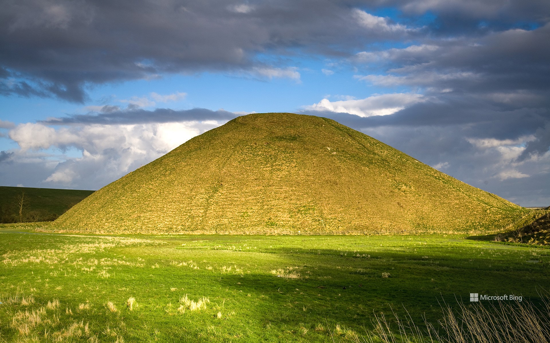
西尔布利山的新石器时代遗址,蒂尔斯黑德,威尔特郡,英国 Neolithic site of Silbury Hill, Tilshead, Wiltshire, England (© dbstockphotoa/Getty Images)
那座铭记往昔的山丘 The hill that remembers
国际考古日
每年十月的第三个星期六是国际考古日,它鼓励我们“深入地表”,探索尘封的历史与文明的根源。该纪念日由美国考古学会(AIA)于2011年设立,如今世界各地通过举办活动、组织参观和亲身体验挖掘等方式来庆祝。
一些遗址,如图中所示,能与周围环境浑然天成地融为一体:乍看之下,英国威尔特郡的锡尔伯里山或许只是乡间一道普通的斜坡。然而它却隐藏着一个距今约4500年的新石器时代谜团。自公元前2400年左右起,当地人开采白垩岩,经世代人力层层搬运堆砌,最终建成这座欧洲最高的史前土丘——它完全依靠人力堆砌而成,高约129英尺。
它究竟是祭祀场所、宇宙标记,还是社群象征?这座山丘的原始用途至今仍是谜题,而对考古学而言,这些疑问往往比答案更珍贵。当文字记载缺失时,大地诉说着自己的故事。锡尔伯里山保存着这些沉默的记忆,提醒我们探究过往的意义何在——它重塑我们对历史的认知,放大被掩盖的声音,并昭示着历史永无终结。
Silbury Hill for International Archaeology Day
Each year, International Archaeology Day—observed on the third Saturday of October—invites us to literally look beneath the surface. Established in 2011 by the Archaeological Institute of America (AIA), it's celebrated worldwide through events, tours, and hands-on excavations.
Each year, International Archaeology Day—observed on the third Saturday of October—invites us to literally look beneath the surface. Established in 2011 by the Archaeological Institute of America, it's celebrated worldwide through events, tours, and hands-on excavations.
Was it a ceremonial site, a cosmic marker, a symbol of community? Its original purpose remains elusive, and for archaeology, the questions can be as valuable as the answers. Where written records fail, the land tells its story. Silbury Hill preserves these tales, reminding us why studying our past matters: it rewrites what we thought we knew, amplifies silenced voices, and shows us that history is never finished.
罗克河瀑布,上半岛,密歇根州,美国 Rock River Falls, Upper Peninsula, Michigan (© Matt Anderson Photography/Getty Images)
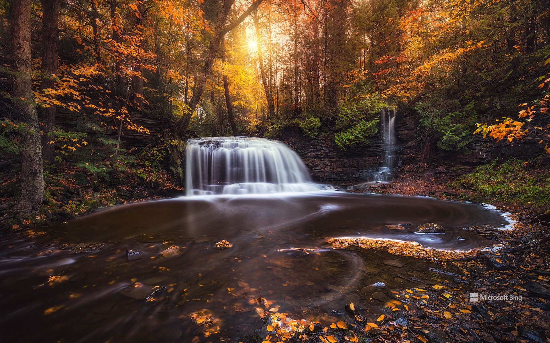
罗克河瀑布,上半岛,密歇根州,美国 Rock River Falls, Upper Peninsula, Michigan (© Matt Anderson Photography/Getty Images)
爱上密歇根 Falling for Michigan
罗克河瀑布,上半岛,密歇根州
密歇根州罗克河峡谷深处,罗克河瀑布在冰川雕琢的景观中悄然显现,周遭密林环绕,层层历史沉淀。在上半岛这片土地上,人类足迹绵延数千年:原住民阿尔冈昆语族之后,法国与英国探险者接踵而至;19世纪采矿与伐木业繁荣时期,芬兰、瑞典及法裔加拿大移民在此定居。如今这片人烟稀少的区域仅容纳着密歇根州3%的居民,森林与瀑布依旧保留着近乎原始的宁静。
要抵达瀑布,需沿着蜿蜒小径徒步前行,途中松柏参天、枫树成荫,林荫下蕨类与野花尽情舒展。红松鼠穿梭其间,白尾鹿悄然移动,鸥鸟与啄木鸟的鸣叫在海瓦萨国家森林回荡。小径尽头,一道18英尺高的瀑布倾泻而下,汇入清澈水潭。随着季节更替,这里展现出不同的风貌:夏日阳光在水面流转跳跃,秋日将树冠染成绚烂火海,冬日则为岩石披上晶莹冰晶。在罗克河瀑布,每一次造访,都是一次感官与自然灵魂的全新邂逅。
Rock River Falls, Upper Peninsula, Michigan
Nestled within Michigan's Rock River Canyon Wilderness, Rock River Falls emerges amid a landscape shaped by glaciers, dense woods, and layers of history. In the Upper Peninsula, humans have left their traces for millennia: Indigenous Algonquian-speaking peoples were followed by French and British explorers, and waves of Finnish, Swedish, and French-Canadian immigrants settled there during the 19th-century mining and logging booms. Today, this sparsely populated region hosts barely 3% of Michigan's residents, cradling its forests and waterfalls in near-natural serenity.
Reaching the falls requires a moderately challenging hike along winding paths lined with towering pines and maples, their shade cooling the ferns and wildflowers below. Red squirrels dart, white-tailed deer move silently, and the calls of loons and pileated woodpeckers echo through the Hiawatha National Forest. At the trail's end, the 18-foot waterfall spills into a clear pool, transformed by seasonal shifts: summer light flickers across the water, autumn sets the canopy ablaze, and winter drapes ice over rocks in glistening formations. At Rock River Falls, each visit offers a fresh sensory journey through the wild soul of northern Michigan.
伊亚镇,圣托里尼岛,希腊 Village of Oia, Santorini, Greece (© f9photos/Getty Images)
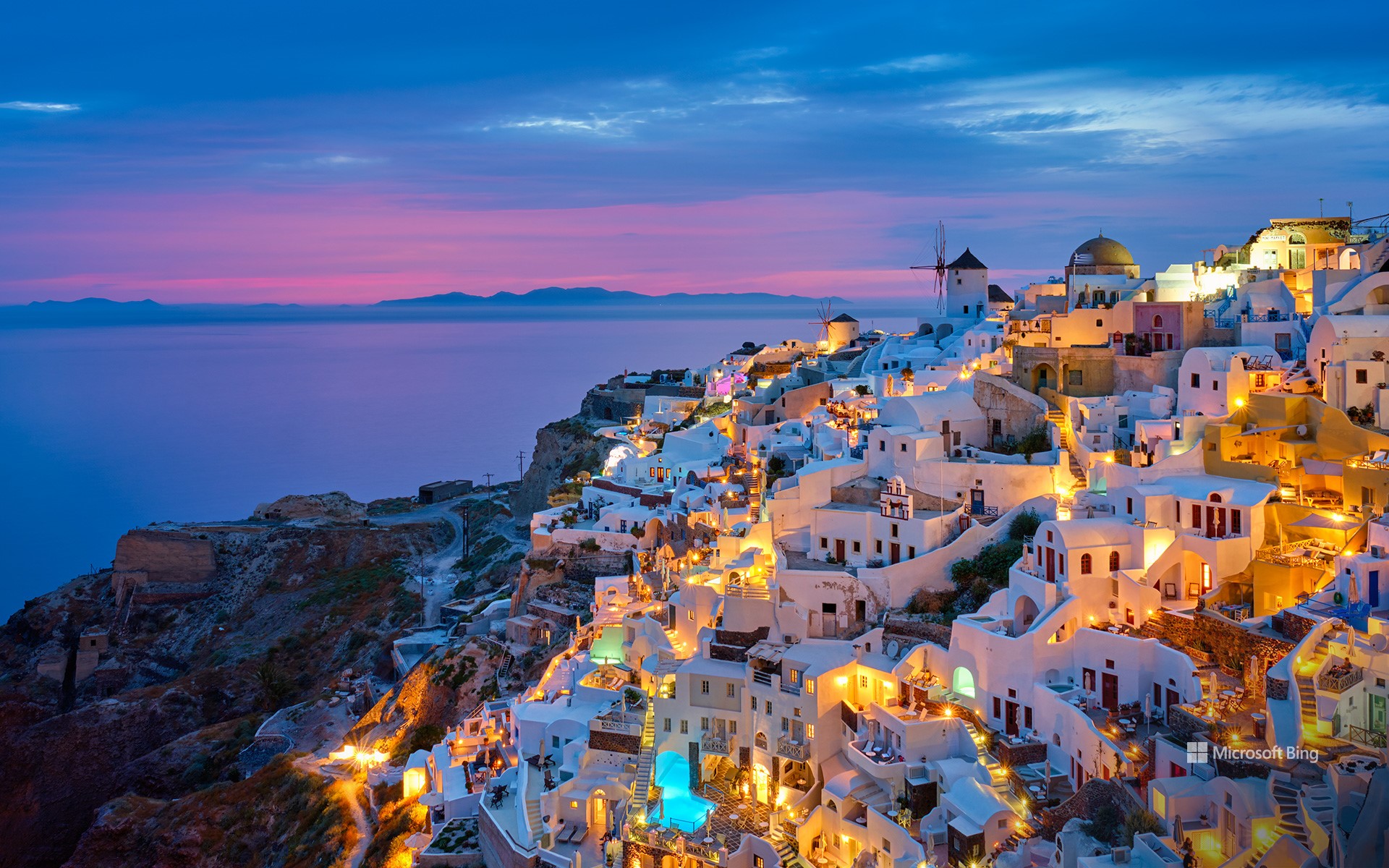
伊亚镇,圣托里尼岛,希腊 Village of Oia, Santorini, Greece (© f9photos/Getty Images)
蓝与白的梦境 Dreams painted in blue and white
伊亚镇,圣托里尼岛,希腊
你是否曾想过生活在电影布景中是什么感觉?在希腊圣托里尼群岛的伊亚村,这种体验几乎成真。这里曾出现在《牛仔裤的夏天》和《古墓丽影》等影片中。标志性的基克拉迪式建筑——立方体造型、平顶的白色房屋——与悬崖边的壮丽景色,仿佛不属于现实世界。它独特的建筑风格起源于19世纪末,当时的水手和商人直接在火山悬崖上凿建房屋,夏季清凉、冬季温暖。而蓝白相间的粉刷,也不仅仅是为了美观:石灰涂层能让雨水顺流而下并被收集利用。如今,游客可以漫步在鹅卵石铺就的小巷中,参观海军海事博物馆,或登上圣尼古拉斯城堡遗址,欣赏那令人难忘的落日。
伊亚素有“鹰巢”之称,俯瞰着帕利亚岛和尼亚·卡美尼岛这两座火山岛,以及曾在公元前1600年米诺斯火山喷发前与圣托里尼岛相连的特拉西亚岛。而圣托里尼本身,则宛如大海中的一顶岩石王冠——一座半沉入海底的巨大火山口,由公元前1600年的那场喷发塑造,那是人类历史上规模最大、最剧烈的火山爆发之一。
Village of Oia in Santorini, Greece
Ever wondered what it's like to live on a movie set? Oia is about as close as it gets, part of Greece's Santorini archipelago. This village has appeared in films like 'The Sisterhood of the Traveling Pants' and 'Tomb Raider,' thanks to its Cycladic houses—cube-shaped homes with flat roofs—and cliffside views that feel almost unreal. Its unique architecture has roots in the late 19th century. Sailors and merchants carved houses right into the volcanic cliffs—cool in summer and warm in winter. The white-and-blue theme is also more than just for show: houses were painted with lime wash so rainwater would run off and be collected. Today, visitors wander its cobbled lanes, explore the Naval Maritime Museum, or climb to the ruins of Agios Nikolaos Castle for unforgettable sunsets.
Nicknamed the 'Eagle's Nest,' Oia overlooks the volcanic islets of Palia and Nea Kameni, as well as Therasia, which was physically connected to Santorini before the Minoan eruption. And Santorini itself? Think of it as a crown of rock around the sea, a half-sunken caldera shaped by the eruption of 1600 BCE, one of the largest volcanic eruptions in human history.
温巴赫峡谷瀑布,巴伐利亚州,德国 Waterfall in Hintersee, Bavaria, Germany (© EyeEm Mobile GmbH/Getty Images)
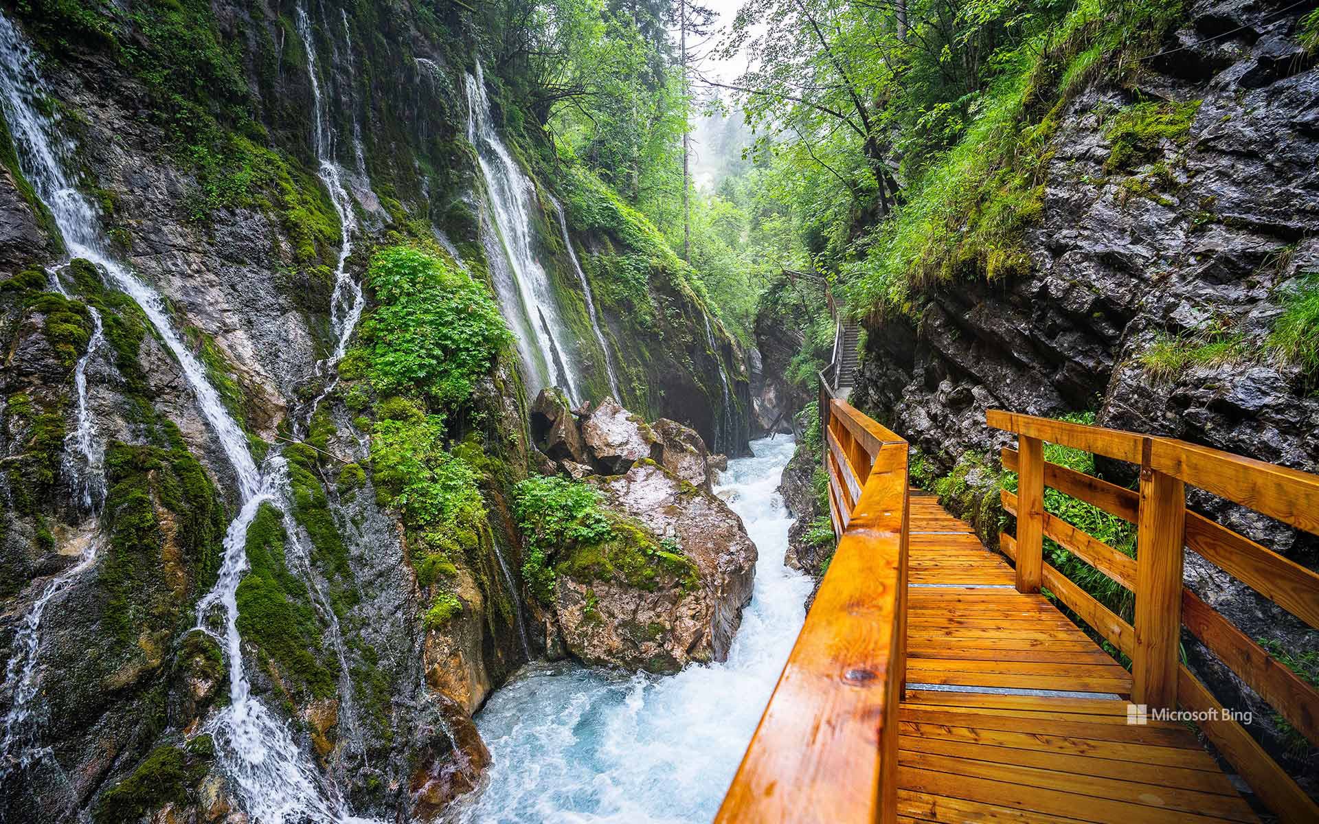
温巴赫峡谷瀑布,巴伐利亚州,德国 Waterfall in Hintersee, Bavaria, Germany (© EyeEm Mobile GmbH/Getty Images)
水声低语 Where water speaks
温巴赫峡谷瀑布,巴伐利亚州,德国
陡峭的岩石峡谷,湍急的水流,还有如画般的风景:位于贝希特斯加登国家公园拉姆绍附近的温巴赫峡谷,是巴伐利亚最壮观的峡谷之一。在今日图片中,温巴赫溪在约200米长的狭窄岩层间奔流而下,形成层层小瀑布,并在长年累月中于岩石上雕刻出令人惊叹的纹理。色彩斑斓的岩层揭示了数千年前的地质过程。
稳固的木质栈道紧贴悬崖修建,引领游客穿行于这条狭窄峡谷之中。走到尽头,壮阔的温巴赫山谷豁然展开,坐落在瓦茨曼山与霍赫卡尔特山之间,这里也是远足登山的热门起点。自1847年向公众开放以来,峡谷凭借其沉浸式的自然之美持续吸引着各个年龄层的游客。尤其在春季,随着雪水融化、溪流暴涨,峡谷景观更显震撼。在这里徒步,就像进行一场时光之旅,亲眼见证大自然原始而磅礴的力量。
萨拉纳克湖村,阿迪朗达克山脉,纽约州,美国 Village of Saranac Lake, Adirondack Mountains, New York (© DenisTangneyJr/Getty Images)
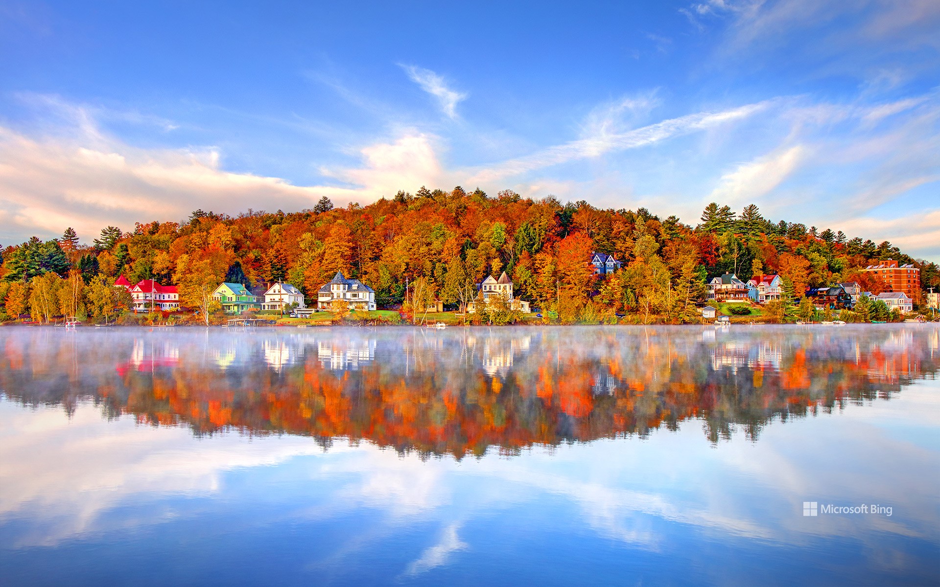
萨拉纳克湖村,阿迪朗达克山脉,纽约州,美国 Village of Saranac Lake, Adirondack Mountains, New York (© DenisTangneyJr/Getty Images)
爱上萨拉纳克 Falling for Saranac
萨拉纳克湖村,纽约州
有些地方只是地图上的一个点,但萨拉纳克湖却是一年四季都吸引游客的热门目的地。尽管名字里带“湖”,这个小镇并不直接坐落在萨拉纳克湖群边,而是位于萨拉纳克河的一段宽阔水域——弗劳尔湖畔。几个世纪以来,这片被称为“阿迪朗达克之都”的地方,一直是原住民狩猎和迁徙的要地。到19世纪末,这里因成为疗养胜地而声名鹊起,爱德华·李文斯顿·特鲁多医生在此开创了肺结核的新鲜空气疗法。那一时期的“疗养小屋”至今依然保存完好。
如今,萨拉纳克湖早已从治病救人转变为治愈无聊的好去处。游客们可以在水道上划桨,攀登高峰,冬天则能体验滑雪和冰钓的乐趣。村子里也同样充满艺术气息,画廊、音乐和社区节庆让文化与户外活动同样重要。本地的商店和餐馆更为旅程增添滋味,从新鲜鳟鱼到精酿啤酒应有尽有。每年举办的冬季嘉年华是最大亮点,其中的冰宫仿佛出自冰雪童话,足以证明这个小镇很懂得如何留下“酷”的印象——不论是氛围,还是温度。
Village of Saranac Lake, New York
Some places are just stops on the map, but Saranac Lake in New York's Adirondack Mountains is a destination that keeps people hooked year-round. Despite its name, this village isn't directly on the Saranac Lakes themselves but rather on Lake Flower, a wide section of the Saranac River. For centuries, the area—nicknamed 'The Capital of the Adirondacks'—was used by Indigenous peoples for hunting and travel. By the late 19th century, it gained fame as a health retreat, where Dr. Edward Livingston Trudeau pioneered fresh-air treatment for tuberculosis. The cure cottages from that era still stand today.
Today, Saranac Lake has shifted from curing patients to curing boredom. Visitors paddle the waterways, hike the High Peaks, and enjoy winter activities like skiing and ice fishing. The village also boasts a lively arts scene, with galleries, music, and community festivals making culture as central as the outdoors. Local shops and restaurants add flavor, serving everything from trout to craft beer. The annual Winter Carnival is a highlight, complete with an ice palace that looks like something out of a frosty fairy tale, proving this village knows how to make a cool impression—literally.
莫努里基岛周边的珊瑚礁,玛玛努卡群岛,斐济 Coral reef surrounding the island of Monuriki, Mamanuca Islands, Fiji (© David Wall/SuperStock)
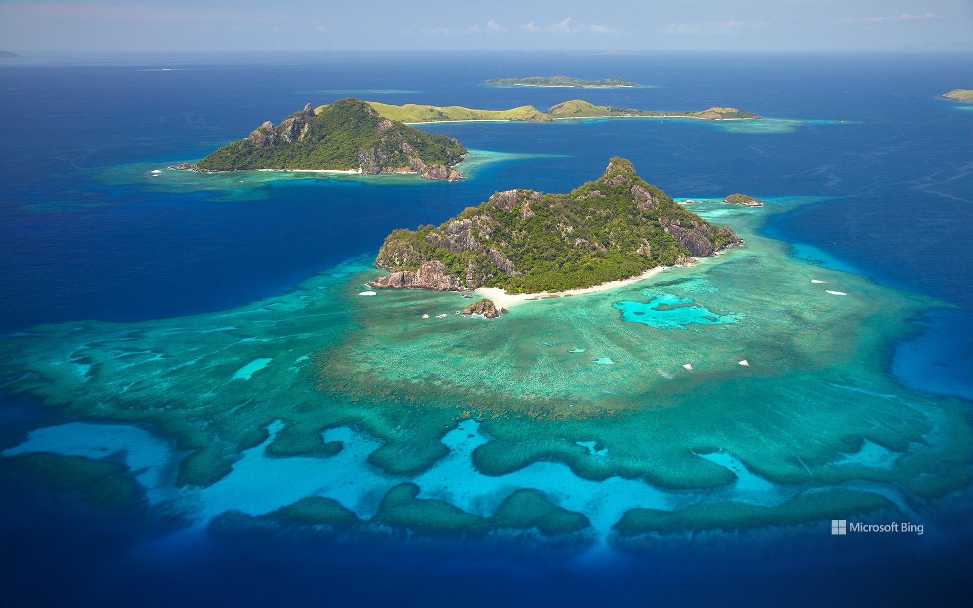
莫努里基岛周边的珊瑚礁,玛玛努卡群岛,斐济 Coral reef surrounding the island of Monuriki, Mamanuca Islands, Fiji (© David Wall/SuperStock)
思绪之礁 A reef of reflection
莫努里基岛,玛玛努卡群岛,斐济
有些日子只标志着一个里程碑,而斐济的10月10日却见证了两个。1874年的这一天,斐济群岛正式成为英国殖民地。近一个世纪后的1970年,同一天,斐济升起了自己的国旗,宣布独立。斐济日是一个独特的全国性节日——既是反思的时刻,也是庆祝的日子。庆典从庄重的仪式开始,国旗冉冉升起,领导人发表演讲。学校和社区团体常常会举行历史重现或表演活动。街道上挤满了游行队伍,村庄里上演着传统舞蹈“梅克”,橄榄球场上热火朝天。家家户户则准备传统菜肴,比如将肉和根茎类作物埋在地下烤制的“洛沃”,以及用柑橘汁腌制的鱼“科科达”。
如今,自由的精神从繁华的城镇延伸到像莫努里基岛这样的偏远瑰宝,如今日图片所示。这座岛因《荒岛余生》的拍摄而名声大噪,虽无人居住,却绝非死寂。环绕小岛的珊瑚礁宛如天然的堡垒,既能抵御风暴侵袭,又庇护着无数鱼类。斐济的珊瑚礁恰如其分地成为了一个隐喻:坚固、多样且与国家的福祉紧密相连。
Visiting the Mamanuca Islands for Fiji Day
Some dates mark a single milestone—Fiji's October 10 marks two. On that day in 1874, the islands officially became a British colony. Almost a century later, in 1970, the same date saw Fiji raise its own flag and declare independence. Fiji Day is a unique national holiday—part reflection, part celebration. The day begins with formal ceremonies, where the Fijian flag is hoisted and leaders deliver speeches. Schools and community groups often stage reenactments and performances. Streets fill with parades, villages host cultural dances like the meke, and rugby pitches come alive with matches. Families prepare traditional dishes like lovo, where meat and root crops are cooked underground, and kokoda, a citrus-marinated fish dish.
Today, the spirit of freedom stretches from bustling towns to remote gems like the island of Monuriki, pictured here. Known worldwide as the filming site of 'Cast Away,' the island is uninhabited—but far from lifeless. Its surrounding coral reef acts as a natural fortress, protecting the island from storms while sheltering countless species of fish. The reefs of Fiji are a fitting metaphor: strong, diverse, and deeply connected to the well-being of the nation.