标签 国家公园 下的文章
约克郡谷地国家公园里的山丘,英格兰 Howgill Fells in the Yorkshire Dales National Park, England (© davidnmoorhouse/iStock/Getty Images Plus)
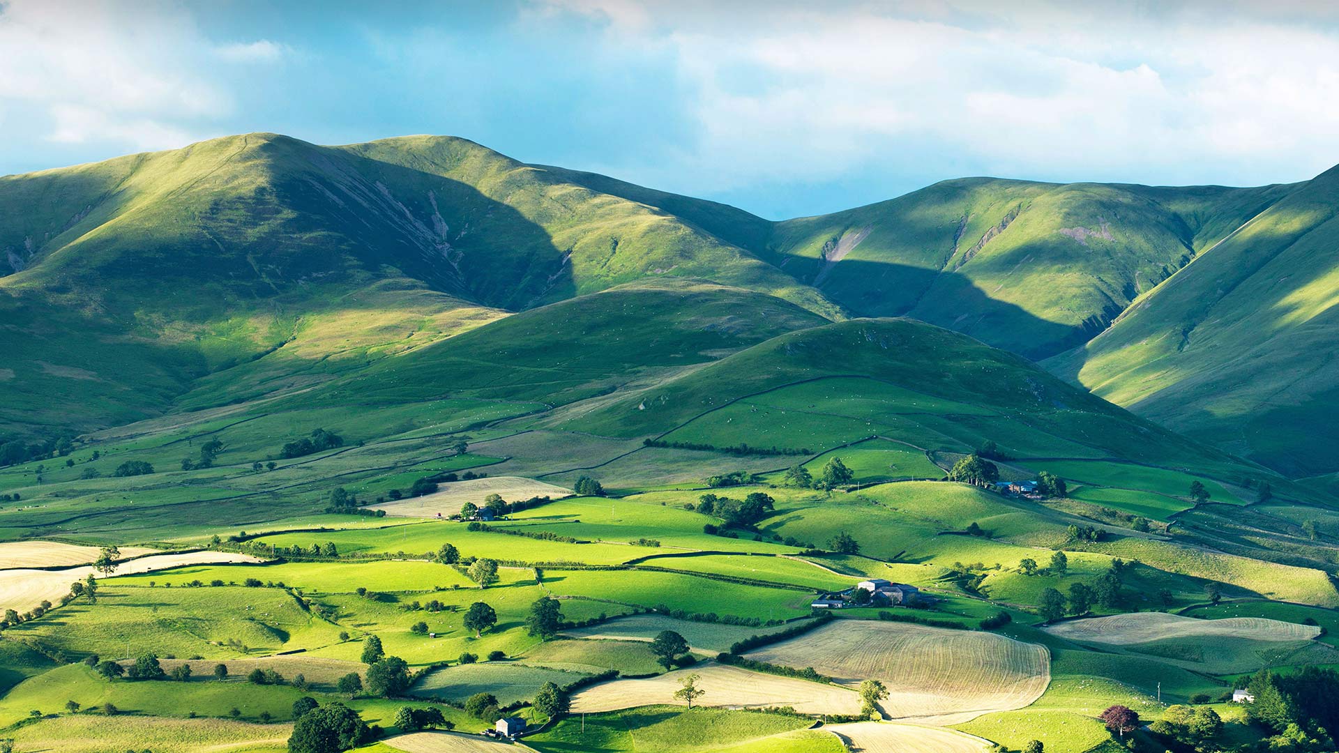
约克郡谷地国家公园里的山丘,英格兰 Howgill Fells in the Yorkshire Dales National Park, England (© davidnmoorhouse/iStock/Getty Images Plus)
Between the Lakes and the Dales
Nestled between the Yorkshire Dales and the Lake District, the smooth rounded shapes and steep gills (ravines) of the Howgill Fells capture an eye-catching pattern of light and shade. These ancient hills, formed more than 400 million years ago, have remained a largely settlement-free zone, uncrossed by roads and untouched by development. Trees are scarce on the high ground, where sheep and wild ponies graze and small streams tumble down dark, narrow gullies and the panoramic views from the fells are a sight worth climbing for. The highest point is the top of The Calf, at 2,218ft (676m), from where hikers can enjoy a 20-mile skyline of the Lakeland peaks, the Yorkshire Three Peaks and the nearer Howgill peaks.
Part of the range sits within Yorkshire Dales National Park, although they are actually in the county of Cumbria. The Howgill Fells’ striking appearance was perhaps best summed up by the famed fell walker and guide book author A. Wainwright as “sleek and smooth, looking from a distance like velvet curtains in sunlight, like silken drapes at sunset … a remarkable concentration of summits often likened to a huddle of squatting elephants”.
湖与谷之间
坐落在约克郡山谷和湖区之间的豪吉尔森林,平滑的圆形和陡峭的鳃(沟壑)捕捉到了引人注目的明暗模式。这些形成于4亿多年前的古老山丘一直是一个基本上没有定居点的区域,没有道路交叉,也没有开发。高地上树木稀少,绵羊和野马在那里吃草,小溪从黑暗狭窄的沟壑中滚滚而下,从山林中俯瞰全景是一个值得攀登的景观。最高点是小牛的顶部,海拔2218英尺(676米),徒步旅行者可以在这里欣赏20英里的湖畔山峰、约克郡三峰和更近的豪吉尔峰的天际线。
部分山脉位于约克郡山谷国家公园内,尽管它们实际上位于坎布里亚县。豪吉尔·费尔斯引人注目的外表也许是著名的费尔沃克和导游书作者A的最佳概括。温赖特被称为“光滑光滑,从远处看,就像阳光下的天鹅绒窗帘,像日落时的丝绸窗帘……山峰的显著集中常常被比作一群蹲着的大象”。
死亡谷国家公园里的优比喜比火山口,加利福尼亚州 Ubehebe Crater in Death Valley National Park, California (© Albert Knapp/Alamy)
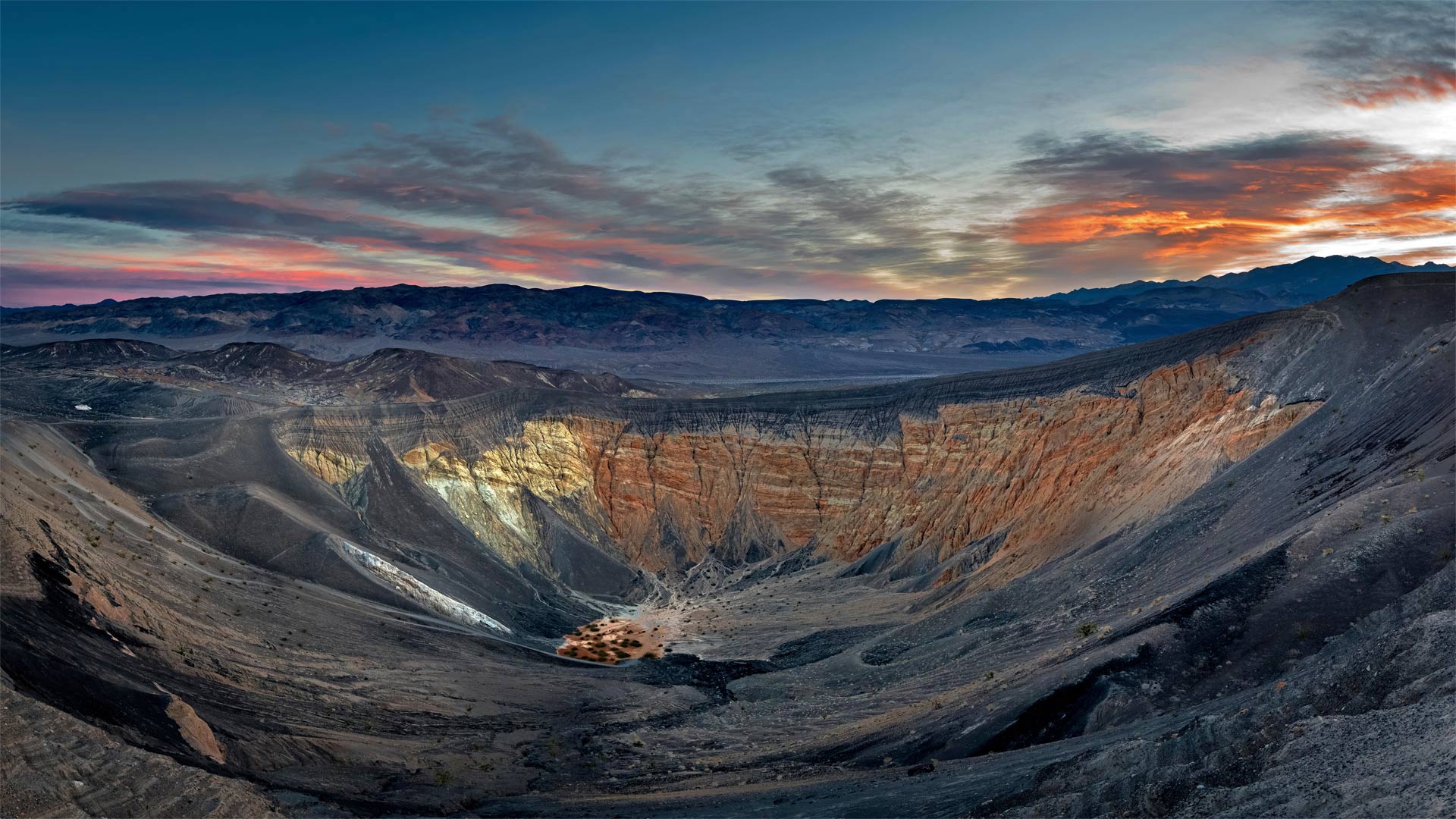
死亡谷国家公园里的优比喜比火山口,加利福尼亚州 Ubehebe Crater in Death Valley National Park, California (© Albert Knapp/Alamy)
When Death Valley blew its top
Deep below Death Valley's charred surface, blazing hot magma once gushed up through a geologic fault until it hit groundwater. The magma quickly turned the water to steam, and like a defective subterranean pressure cooker, the Earth's crust blew its top in a ferocious explosion. The hydrovolcanic eruption sent up a mushroom cloud of steam and spewed burnt volcanic cinders for miles. It also left the giant crater seen in this photo and 12 smaller ones spread across the surface.
The Ubehebe Crater (pronounced you-bee-HEE-bee) is a half-mile across and more than 700 feet deep. Geologically speaking, Ubehebe and the other craters here are quite young. A 2016 study concluded that the craters were all formed in a relatively brief series of explosions—a period of days or weeks—about 2,100 years ago. Another eruption could happen, but visitors need not worry about the ground below their feet—seismometers in the region will alert geologists in advance of any future volcanic unrest. A trail around the rim of the crater offers views of the colorful layers of stone along the walls. Adventurous hikers can descend to the bottom, but it's a long slog back out again, especially on a sweltering summer day.
当死亡谷爆发时
在死亡谷烧焦的地表深处,炽热的岩浆曾经通过地质断层喷涌而出,直到触及地下水。岩浆很快将水变成蒸汽,就像一个有缺陷的地下压力锅,地壳在猛烈的爆炸中炸开了顶部。水火山喷发喷出蘑菇状的蒸汽云,喷出燃烧的火山灰数英里。它还留下了这张照片中看到的巨大陨石坑,12个较小的陨石坑散布在地表。
Ubehebe火山口(发音为you bee HEE bee)宽半英里,深700多英尺。从地质学的角度来说,乌贝赫比和这里的其他陨石坑都很年轻。2016年的一项研究得出结论,这些陨石坑都是在相对短暂的一系列爆炸中形成的——大约2100年前的几天或几周时间。另一次火山喷发可能会发生,但游客不必担心脚下的地面。该地区的地震仪将在未来的火山动荡之前提醒地质学家。沿着火山口边缘的小径可以看到沿着墙壁的彩色石层。喜欢冒险的徒步旅行者可以爬到水底,但要想再次爬出来还需要很长时间,尤其是在炎热的夏天。
纳汉尼国家公园保护区的鸟瞰图,加拿大西北部 (© Robert Postma/Getty Images)
圆顶礁国家公园的大教堂谷,犹他州 Mesas, Upper Cathedral Valley, Capitol Reef National Park, Utah (© Tim Fitzharris/Minden Pictures)
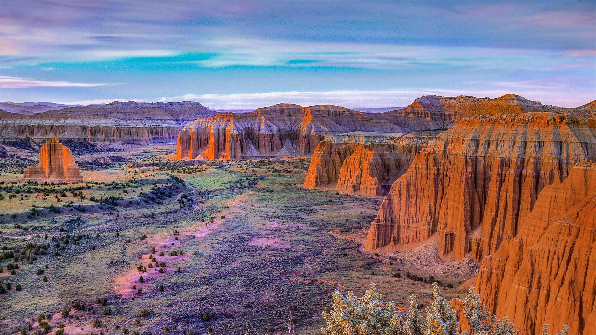
圆顶礁国家公园的大教堂谷,犹他州 Mesas, Upper Cathedral Valley, Capitol Reef National Park, Utah (© Tim Fitzharris/Minden Pictures)
This 'reef' is nowhere near the sea…
…nor the US Capitol building it's named for. Utah's Capitol Reef National Park—first established as a national monument this day in 1937—is named for its massive rock domes that reminded explorers of that famous rotunda back in Washington, DC. Why Capitol 'Reef,' though? Because the imposing formations were a major obstacle to travelers through the region, the same way a coral reef is an obstacle to sailors.
This section of the park, Cathedral Valley, is dotted with monoliths that differ from the namesake domes, instead featuring sheer, jagged walls. While most of the park rests on a steeply warped section of Earth's crust, Cathedral Valley is relatively flat—so rather than carving out gently sloping domes, water erosion here has tended to cut deep, narrow recesses down the rock faces.
这个“暗礁”离海很远…
…也不是以它命名的美国国会大厦。犹他州国会珊瑚礁国家公园于1937年作为国家纪念碑首次建立,以其巨大的岩石圆顶命名,使探险家们想起了华盛顿特区著名的圆形大厅。但为什么国会大厦是“暗礁”?因为壮观的地形是旅行者穿越该地区的主要障碍,就像珊瑚礁是海员的障碍一样。
公园的这一部分,即大教堂谷,点缀着不同于同名圆顶的巨石,取而代之的是陡峭、参差不齐的墙壁。虽然公园的大部分都坐落在地壳急剧弯曲的部分,但大教堂山谷相对平坦,因此这里的水侵蚀倾向于沿着岩石表面切割出深而窄的凹坑,而不是雕刻出缓倾斜的圆顶。
阿卡迪亚国家公园里的水獭悬崖,缅因州 Otter Cliffs, Acadia National Park, Maine (© dbimages/Alamy)
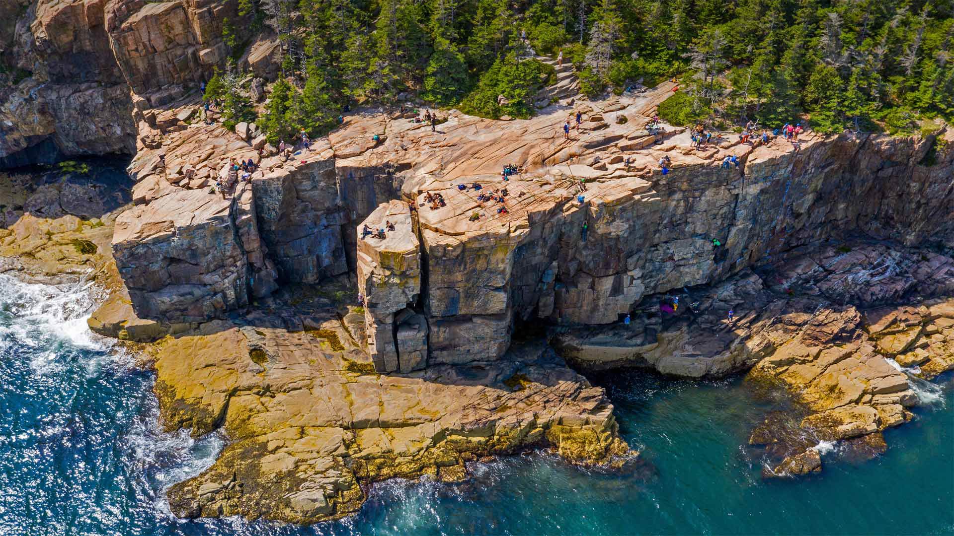
阿卡迪亚国家公园里的水獭悬崖,缅因州 Otter Cliffs, Acadia National Park, Maine (© dbimages/Alamy)
Working for that cliffside view
Maine's Acadia National Park serves up spectacular views at most every turn. But the park's Otter Cliffs on Mount Desert Island offer the adventurous among us a chance to take in the picturesque Atlantic shoreline from the edge of a sheer granite wall. Rising some 60 feet above the crashing waves below, the cliffs are shown here at low tide—when the tide is up, that ledge at the bottom is completely submerged.
The spot's become one of New England's premier climbing destinations, with routes beloved by experts and beginners alike. Climbers begin by either rappelling down the cliff or being lowered from the top. The heart races at the bottom, as waves crash against the seawall right below the climber's shoes and ocean spray makes the first few hand- and footholds slippery. From there, the only way out is up, back to the top of this stunning crag and the cap to a thrilling ascent.
在悬崖边工作
缅因州的阿卡迪亚国家公园最多在每个转弯处都能看到壮观的景色。但公园位于荒山岛上的水獭悬崖为我们中的冒险者提供了一个从陡峭的花岗岩墙边缘欣赏风景如画的大西洋海岸线的机会。这些悬崖高出下面汹涌的海浪约60英尺,在低潮时,当涨潮时,悬崖底部的岩壁完全被淹没。
该景点已成为新英格兰首要的登山目的地之一,其路线深受专家和初学者的喜爱。攀岩者一开始要么从悬崖上攀爬下来,要么从山顶往下爬。当海浪拍打着登山者鞋下的海堤时,心脏在底部跳动,海水的浪花使最初的几个手和脚点变得很滑。从那里出发,唯一的出路就是爬上,回到这座令人惊叹的峭壁的顶端,再爬上令人激动的山峰。
驼鹿穿过莫兰山下的池塘,怀俄明州大提顿国家公园 Moose crossing a pond below Mount Moran, Grand Teton National Park, Wyoming (© Jim Stamates/Minden Pictures)
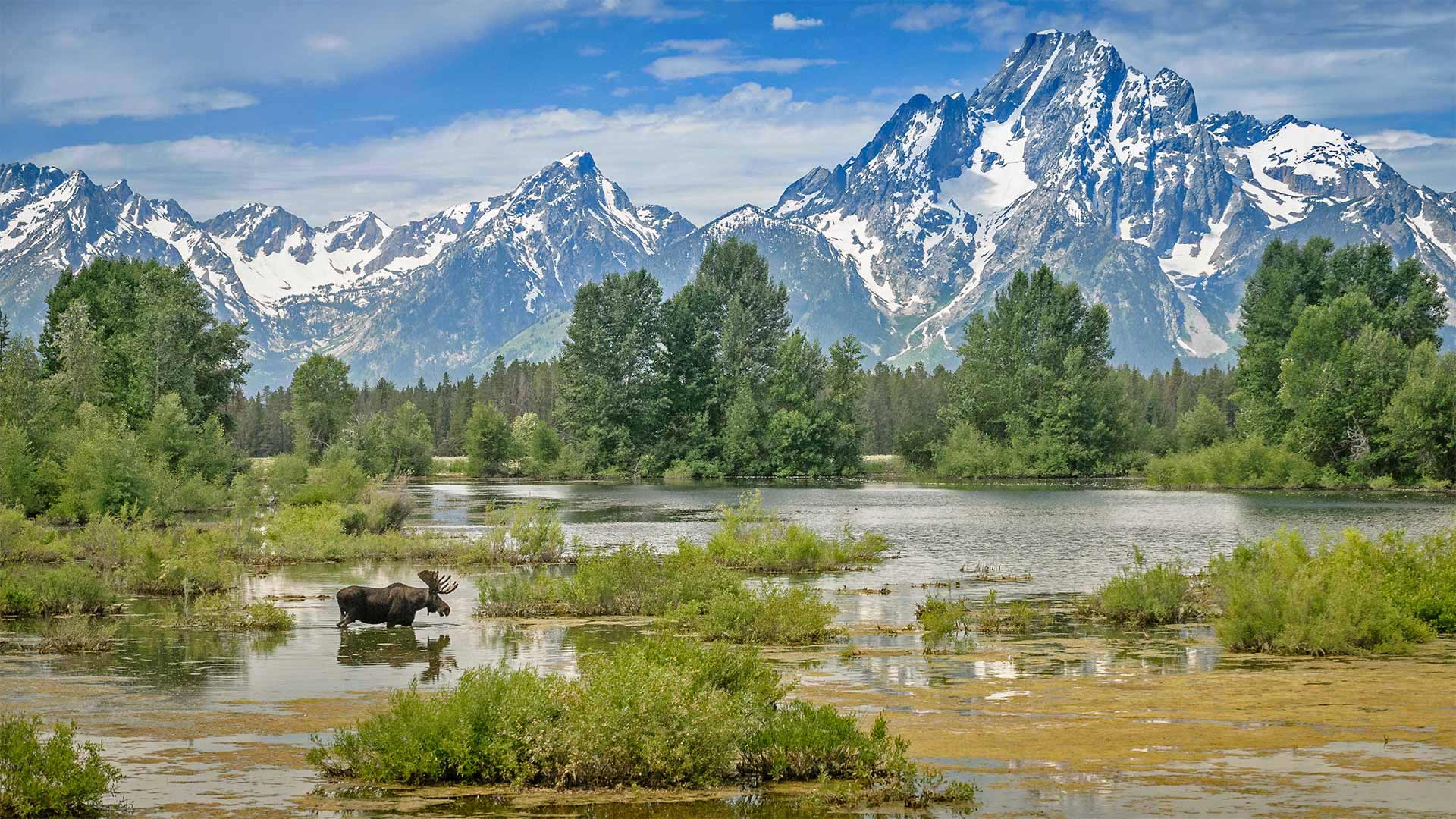
驼鹿穿过莫兰山下的池塘,怀俄明州大提顿国家公园 Moose crossing a pond below Mount Moran, Grand Teton National Park, Wyoming (© Jim Stamates/Minden Pictures)
Through an artist's eyes
If this beautiful view of Grand Teton National Park seems as pretty as a painting, there may be a reason for it. That majestic peak towering over the landscape is Mount Moran, named for Thomas Moran, an American artist of New York's Hudson River School who earned fame by painting scenes of the western frontier. In 1871, Moran and photographer William Henry Jackson were invited on an expedition to the Yellowstone region to accompany a team from the US Geological Society while they conducted the first comprehensive survey of the area. Moran's paintings and Jackson's photographs from the trip immediately captured the public's attention and inspired Congress to establish Yellowstone as the first national park in 1872.
For the next two decades, Moran painted hundreds of landscapes of the Yellowstone region, producing indelible images of this spectacular wilderness that would come to define the American West in the imaginations of many. The area had such an impact on Moran that he adopted the signature T-Y-M, Thomas 'Yellowstone' Moran. He returned to the area in August 1879 on an expedition to the Teton range, just south of Yellowstone National Park. He never made it as far into the mountains as he'd hoped, but gazing up at the towering peaks, he wrote in his diary, 'From this point it is perhaps the finest pictorial range in the United States or even N. America.' Judging from this image, it's hard to argue with him.
透过艺术家的眼睛
如果大提顿国家公园的美景看起来像一幅画一样美丽,那可能是有原因的。这座巍峨的山峰是摩兰山,以纽约哈德逊河学校的美国艺术家托马斯·莫兰的名字命名,他以画西部边疆而闻名。1871年,莫兰和摄影师威廉·亨利·杰克逊应邀到黄石地区探险,陪同美国地质学会的一个小组对该地区进行第一次全面调查。莫兰的画作和杰克逊旅行中的照片立即引起了公众的注意,并在1872年激励国会将黄石公园建成第一个国家公园。
在接下来的20年里,莫兰绘制了黄石地区的数百幅风景画,为这片壮观的荒野绘制了不可磨灭的图像,这些图像将在许多人的想象中成为美国西部的定义。这个地区对莫兰的影响如此之大,以至于他采用了标志性的T-Y-M,托马斯“黄石”莫兰。他于1879年8月返回该地区,前往黄石国家公园以南的提顿山脉探险。他从来没有像他所希望的那样深入山区,但他在日记中写道,仰望巍峨的山峰,从这一点上看,它可能是美国乃至北美最好的画作。从这个形象来看,很难和他争辩。
瓦卡托比国家公园,印度尼西亚 Wakatobi National Park, Indonesia (© Fabio Lamanna/Alamy)
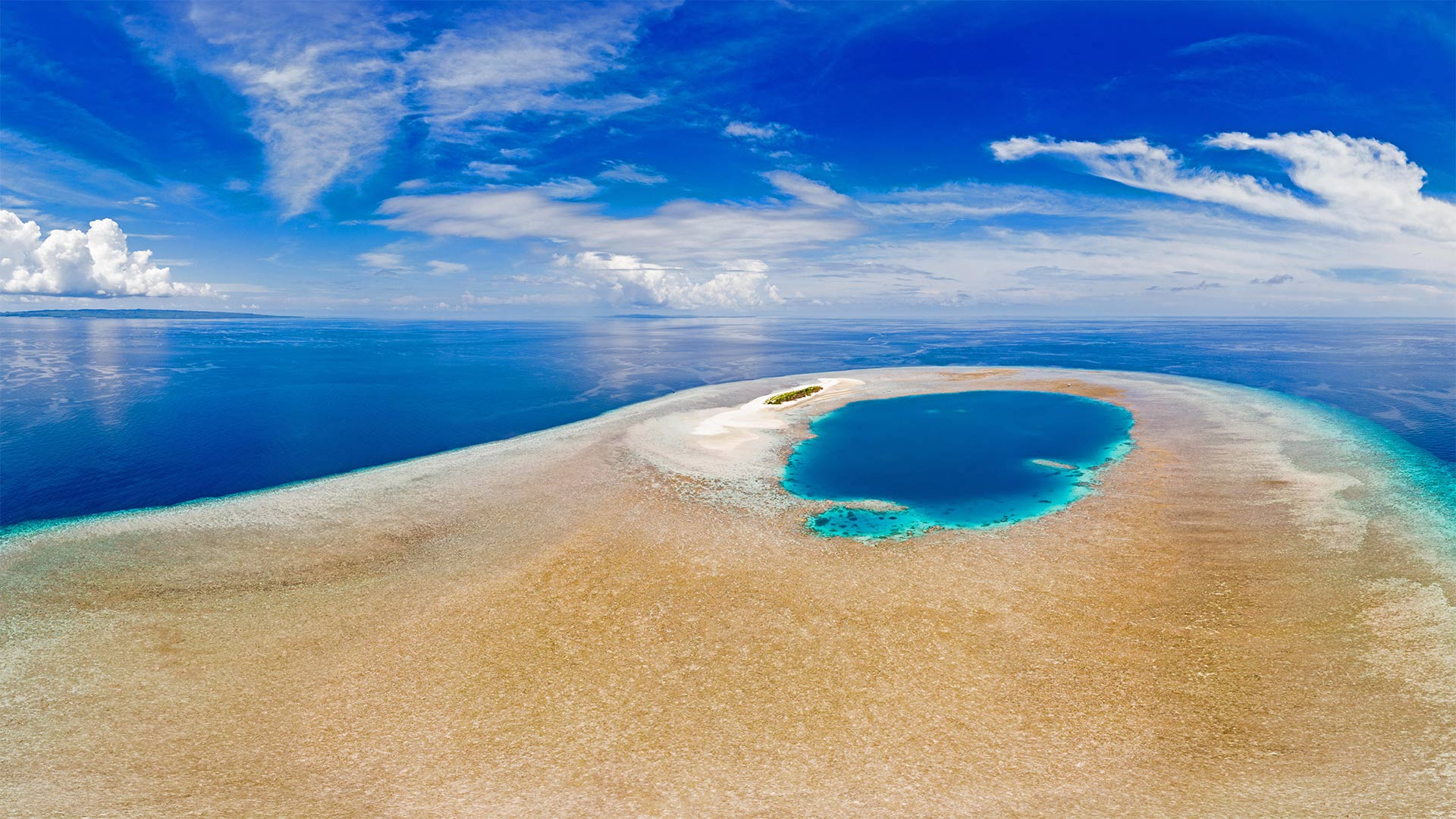
瓦卡托比国家公园,印度尼西亚 Wakatobi National Park, Indonesia (© Fabio Lamanna/Alamy)
Diving into the 'underwater nirvana'
Indonesia's Wakatobi National Park protects one of the most diverse underwater environments in the world. Around 400 species of coral are found in these pristine waters, and they're home to a staggering variety of marine life, including dolphins, whales, turtles, and hundreds of species of fish. The park was established in 2002, preserving more than 5,000 square miles, most of which is covered by coral reefs. In fact, the barrier reef here is second in size only to the Great Barrier Reef and is so full of life that famed oceanographer and explorer Jacques Cousteau is said to have called it an 'underwater nirvana.' Many others have followed in Cousteau's wake, and Wakatobi has become a preeminent destination for diving and snorkeling.
潜入“水下涅盘”
印尼的瓦卡托比国家公园保护着世界上最多样化的水下环境之一。在这些原始水域中发现了大约400种珊瑚,它们是各种海洋生物的家园,包括海豚、鲸鱼、海龟和数百种鱼类。该公园成立于2002年,保护面积超过5000平方英里,其中大部分被珊瑚礁覆盖。事实上,这里的大堡礁面积仅次于大堡礁,充满了生命,据说著名的海洋学家和探险家雅克·库斯托(Jacques Cousteau)将其称为“水下涅磐”。许多其他人跟随库斯托,瓦卡托比已成为潜水和浮潜的卓越目的地。
德纳利国家公园和自然保护区的驯鹿,阿拉斯加 Caribou in Denali National Park and Preserve, Alaska (© Design Pics/Danita Delimont)
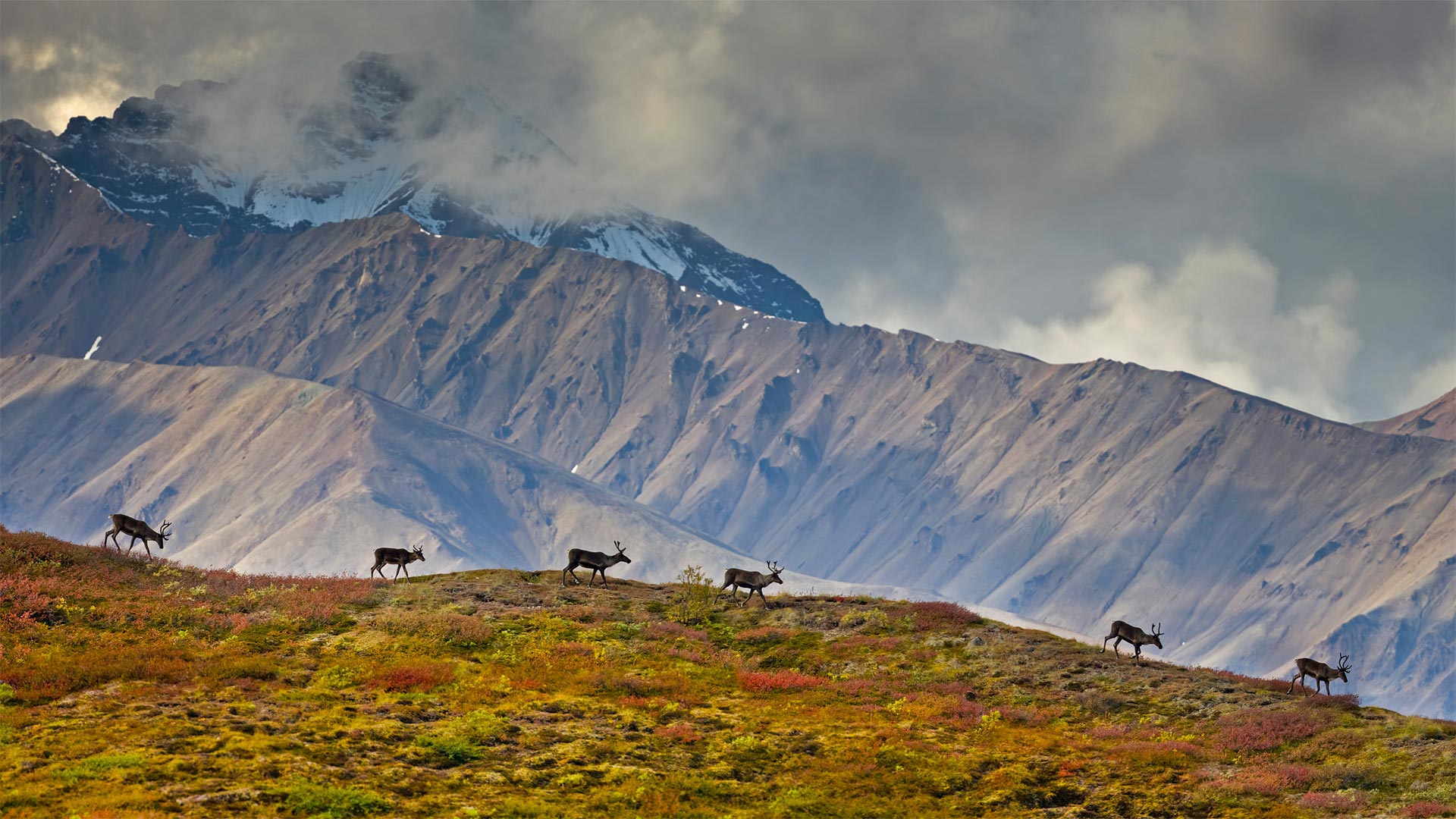
德纳利国家公园和自然保护区的驯鹿,阿拉斯加 Caribou in Denali National Park and Preserve, Alaska (© Design Pics/Danita Delimont)
The call of the wild in Alaska
Most visitors to Denali National Park and Preserve in Alaska come with a checklist for the 'big five' mammals that live here: Grizzly bears, moose, wolves, Dall sheep, and caribou like this small group walking along a ridge. These are barren-ground caribou, a migratory subspecies of caribou found across the arctic band of North America to western Greenland. Barren-ground caribou migrate in large herds, some traveling over 600 miles one way, between their summer and winter ranges. But the Denali herd, today which numbers around 3,000 animals, generally stay on the park's 6 million acres. For good reason, too—they're the only large herd that aren't hunted.
阿拉斯加野性的呼唤
大多数到德纳利国家公园和阿拉斯加自然保护区的游客都会带上一份居住在这里的“五大”哺乳动物的清单:灰熊、驼鹿、狼、大头羊和驯鹿,就像这一小群沿着山脊行走的动物一样。这些是贫瘠的地面驯鹿,驯鹿的一个迁徙亚种,发现于北美洲北极带到格陵兰岛西部。贫瘠的地面驯鹿成群结队地迁徙,有些驯鹿在夏季和冬季之间单程旅行600英里。但如今的德纳利兽群大约有3000头,它们一般都生活在公园的600万英亩土地上。也有很好的理由,它们是唯一没有被猎杀的大型兽群。
加拿大亚伯达省贾斯珀国家公园马利尼湖的精神岛 Spirit Island in Maligne Lake, Jasper National Park, Alberta, Canada (© Jeff Penner/EyeEm/Getty Images)
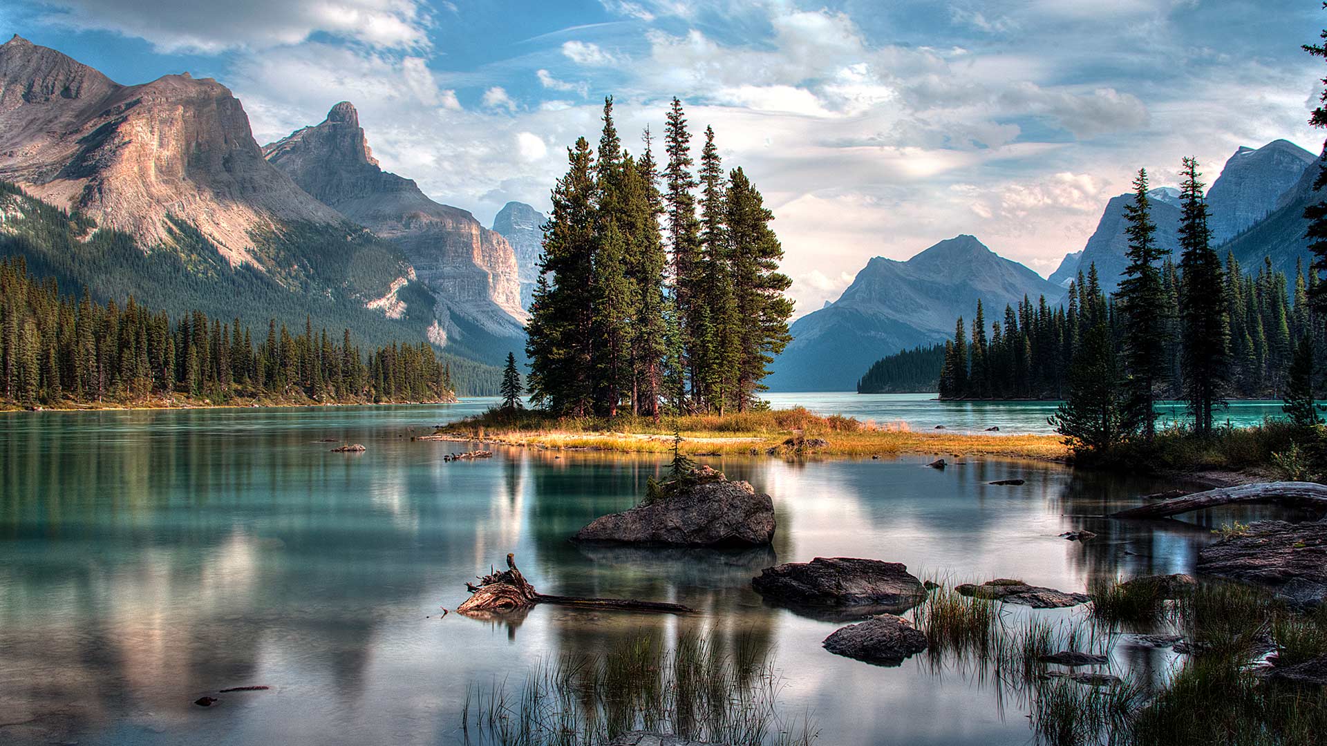
Spirit Island in Maligne Lake, Jasper National Park, Alberta, Canada (© Jeff Penner/EyeEm/Getty Images)
A photographer's paradise
If you are dreaming of an escape to paradise, look no further. Welcome to one of the most photographed sites in the majestic Canadian Rockies. Located in Jasper National Park in Alberta, the scenic Maligne Lake is 22 kilometres long, making it the largest natural lake out here. In the middle of this lake, sits the iconic Spirit Island which is only accessible via tour boats or private boats. The glacial, azure-blue waters, pine trees and snow-capped peaks frame Spirit Island, epitomizing the beauty of Jasper. In addition to admiring the natural beauty here, visitors can engage in activities such as hiking, fishing and kayaking during summer and skiing and snowshoeing in the winter.
摄影师的天堂
如果你梦想着逃往天堂,不要再看了。欢迎来到雄伟的加拿大落基山脉最受欢迎的景点之一。位于艾伯塔省贾斯珀国家公园,风景秀丽的马林湖长22公里,是这里最大的天然湖泊。在这个湖的中央,坐落着标志性的精神岛,只有通过旅游船或私人船只才能到达。冰川、湛蓝的海水、松树和白雪皑皑的山峰构成了精灵岛,是碧玉之美的缩影。除了欣赏这里的自然美景外,游客还可以在夏季进行徒步旅行、钓鱼和皮划艇活动,在冬季进行滑雪和雪鞋运动。
大弯国家公园中里奥格兰德河的景色,德克萨斯州 View of the Rio Grande River in Big Bend National Park, Texas (© Ian Shive/Tandem Stills + Motion)
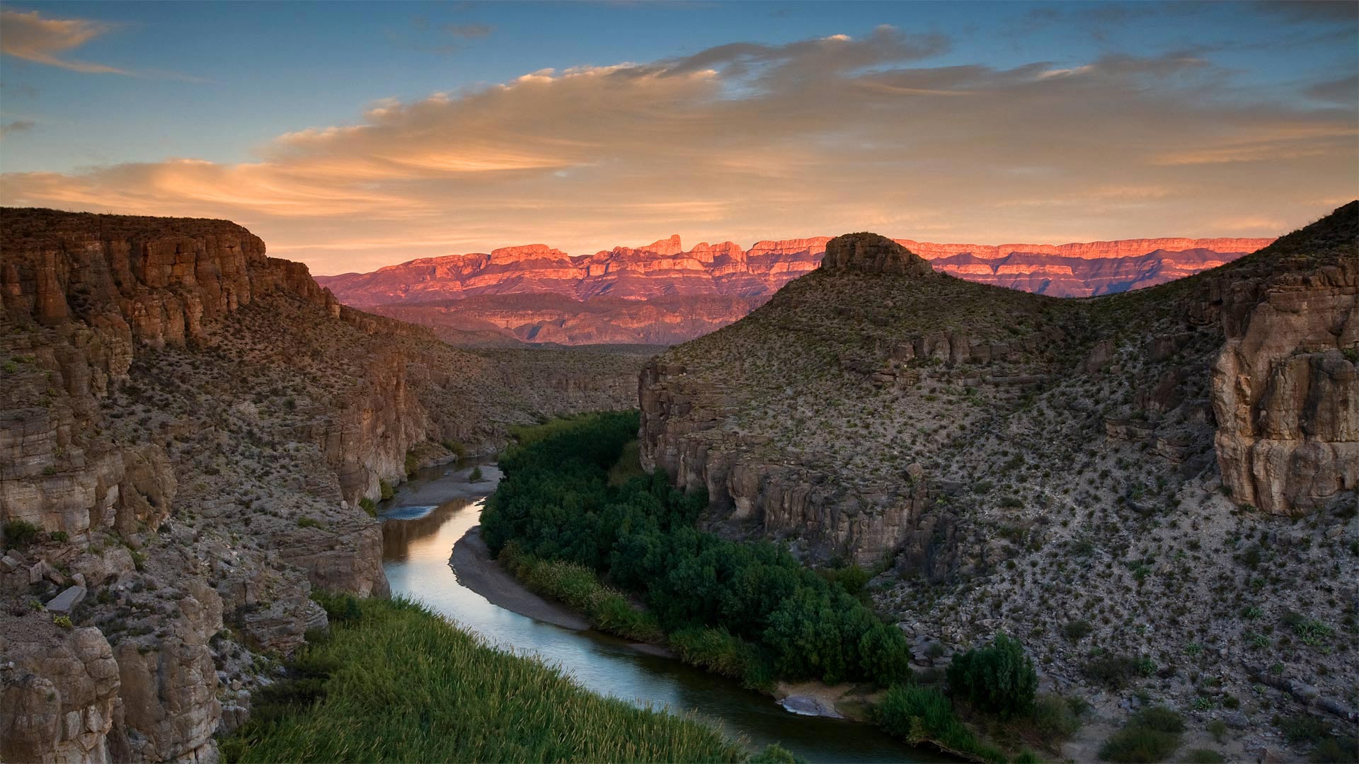
大弯国家公园中里奥格兰德河的景色,德克萨斯州 View of the Rio Grande River in Big Bend National Park, Texas (© Ian Shive/Tandem Stills + Motion)
In Texas, even the riverbend is big
We're celebrating the 77th birthday of Big Bend National Park, the place the National Park Service calls 'one of the last remaining wild corners of the United States.' To get here, you have to be committed. This rugged terrain, which covers almost a million acres, is one of the most remote spots in the country—it's hours from the nearest towns or the closest airport, making it one of the least-visited national parks in the country. Those who do make the effort to get to Big Bend are rewarded with an undeveloped natural beauty, and silence, two things that seem to be in short supply these days.
At Big Bend you'll find craggy hiking trails, red mountain vistas, limestone canyons, and hot springs alongside the famous Rio Grande. There's also the wildlife you'd expect to find in the Wild, Wild West, including rattlesnakes, packs of javelinas, and 20 species of bats. But it's the huge night sky unencumbered by light pollution that draws stargazers to Big Bend from all over the world. After all, everything, as they say, is bigger in Texas.
在德克萨斯州,连河湾都很大
我们正在庆祝大弯国家公园77岁生日,国家公园管理局称之为“美国仅存的野生角落之一”。要到这里,你必须全力以赴。这片崎岖不平的土地占地近百万英亩,是美国最偏远的地区之一,距离最近的城镇或最近的机场只有几个小时的路程,使它成为美国游客最少的国家公园之一。那些努力到达大弯的人得到的回报是未开发的自然美景和沉默,这两样东西现在似乎供不应求。
在大弯,你会发现崎岖的徒步小径、红色的山景、石灰岩峡谷和著名的格兰德河旁的温泉。在野生的西部,你也会发现野生动物,包括响尾蛇,标枪和20种蝙蝠。但正是没有光污染的巨大夜空吸引着来自世界各地的天文爱好者来到大弯。毕竟,正如他们所说,德克萨斯的一切都更大。