标签 国家公园 下的文章
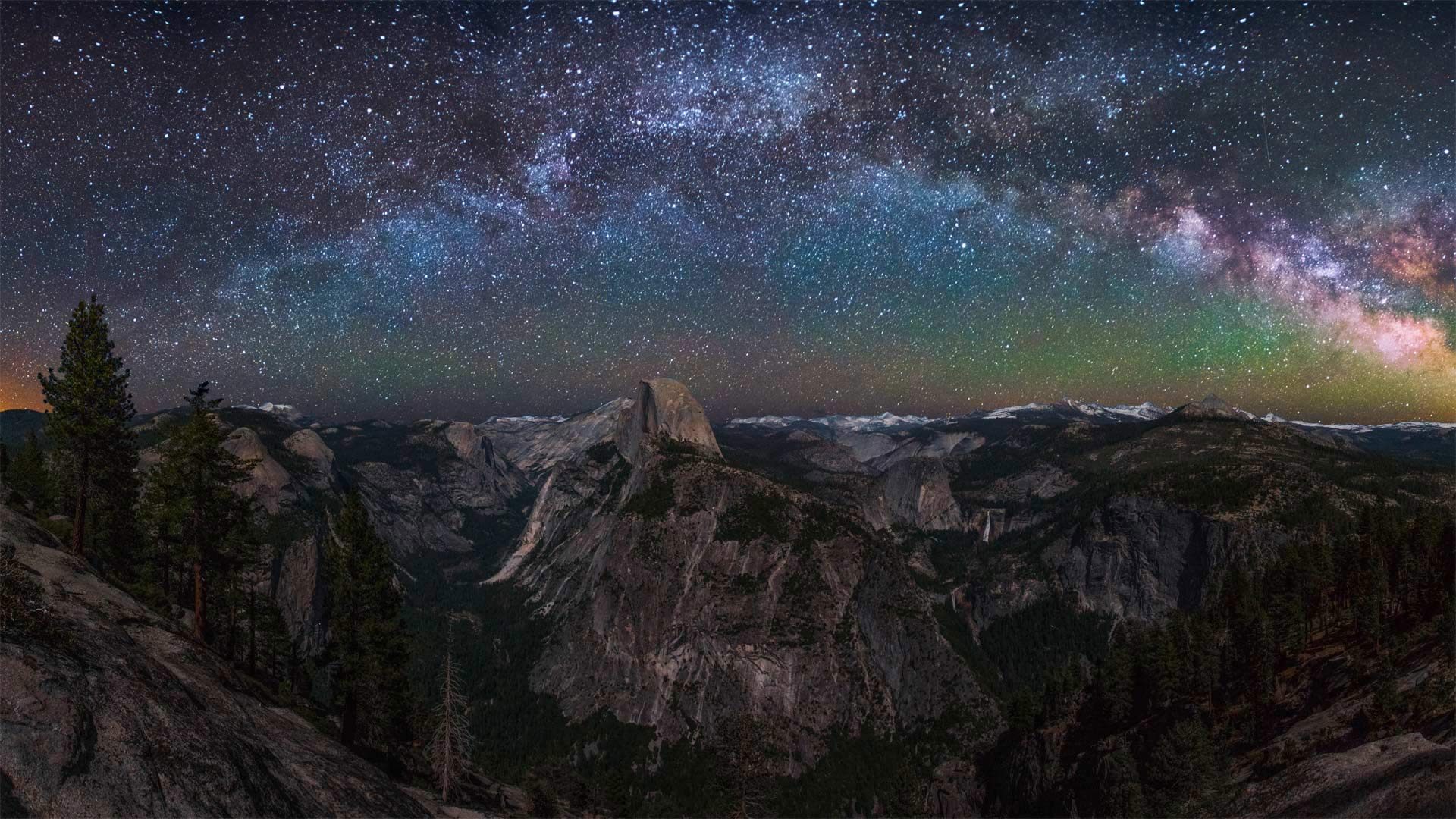
半穹顶景观点上空的银河,优胜美地国家公园,加利福尼亚州 Milky Way rising above Half Dome in Yosemite National Park, California (© Cory Marshall/Tandem Stills + Motion)
半穹顶景观点上空的银河,优胜美地国家公园,加利福尼亚州 Milky Way rising above Half Dome in Yosemite National Park, California (© Cory Marshall/Tandem Stills + Motion)
你能把灯关掉吗? Could you turn off the lights?
Dark Sky Week
During International Dark Sky Week, we're counting ourselves lucky to have this spectacular nighttime view, considering the astonishing fact that 83% of the global population lives under a light-polluted sky. Unneeded artificial light is classified as a pollutant and has been proven to have harmful side effects. Not only does it waste money and energy, it also disrupts plants and animals, is believed to impact the climate, and blocks our view of the universe.
Encouraging people to get away from artificial light is one of the goals of International Dark Sky Week, and today's photo shows just how magnificent that can be. Here, we're treated to a beautiful view of the Milky Way from Yosemite National Park in California. Yosemite is part of a network of national parks monitoring dark night skies to gather a complete data set of light pollution. They've learned that 'two-thirds of Americans cannot see the Milky Way from their backyard, and if current light pollution trends continue, there will be almost no dark skies left in the contiguous United States by 2025.'
Luckily, dark sky is a recoverable resource. There are ways to reduce our light use and improve the view of the night sky for everyone. Think about it over the course of the next week, preferably while gazing at a night sky undisturbed by light pollution—or at least a beautiful photo of one.
黑暗天空周
在国际黑暗天空周期间,考虑到全球83%的人口生活在轻度污染的天空下这一令人震惊的事实,我们认为自己有幸拥有这一壮观的夜景。不需要的人造光被归类为污染物,并已被证明具有有害的副作用。它不仅浪费金钱和能源,还扰乱动植物,被认为会影响气候,阻碍我们对宇宙的看法。
鼓励人们远离人造光是国际黑暗天空周的目标之一,今天的照片展示了这是多么壮观。在这里,我们可以在加利福尼亚州约塞米蒂国家公园欣赏到银河系的美景。约塞米蒂是国家公园网络的一部分,该网络监测黑夜天空,以收集光污染的完整数据集。他们了解到,“三分之二的美国人无法从自家后院看到银河系,如果目前的光污染趋势继续下去,到2025年,毗邻的美国将几乎没有黑暗的天空。”
幸运的是,黑暗的天空是一种可回收的资源。有一些方法可以减少我们的光线使用,改善每个人的夜空视野。在接下来的一周里好好想想,最好是在凝视没有光污染的夜空时,或者至少是一张美丽的照片。
十六湖国家公园,克罗地亚 Plitvice Lakes National Park, Croatia (© Janne Kahila/Getty Images)
十六湖国家公园,克罗地亚 Plitvice Lakes National Park, Croatia (© Janne Kahila/Getty Images)
巴尔干湖上的木板路 Boardwalk over Balkan lakes
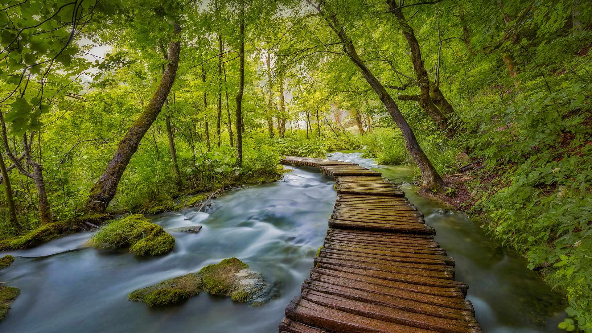
Plitvice Lakes National Park in Croatia
In a country more famous for its coastline, about a million visitors each year venture inland to amble along these boardwalks and marvel at spectacular lakes and mountains. Plitvice Lakes National Park is the oldest and largest of Croatia's national parks. The big attraction is the series of 16 descending, turquoise-colored lakes, connected by subterranean karst rivers, and above ground by streams and waterfalls. The lakes are separated by natural dams of travertine, which is deposited by moss, algae, and bacteria. The water changes color from green to azure to gray depending on the angle of the light and the density of minerals and organisms in the water. About 11 miles of wooden boardwalk make it easy for people to wander among the lakes, falls, and caves that are open to visitors year-round.
The 115-square-mile park was established in 1949 in what is now central Croatia, near the border of Bosnia and Herzegovina. In 1979, Plitvice's unique beauty put it on the list UNESCO World Heritage Sites. The lakes seem to magically disappear into the moss-covered earth, and then reappear downstream, proof enough that these woods are indeed enchanted.
克罗地亚的普利特维兹湖国家公园
在一个以海岸线闻名的国家,每年大约有100万游客冒险到内陆,沿着这些木板路漫步,欣赏壮观的湖泊和山脉。普利特维兹湖国家公园是克罗地亚最古老、最大的国家公园。最大的吸引力是16个下降的绿松石色湖泊,由地下喀斯特河流连接,地面上由溪流和瀑布连接。湖泊之间由苔藓、藻类和细菌沉积的钙华天然坝隔开。根据光线的角度以及水中矿物质和生物体的密度,水的颜色会从绿色变为蓝色再变为灰色。大约11英里长的木板路使人们可以轻松地在全年开放的湖泊、瀑布和洞穴中漫步。
这座115平方英里的公园建于1949年,位于现在的克罗地亚中部,靠近波斯尼亚和黑塞哥维那边境。1979年,普利特维奇独特的美景将其列入联合国教科文组织世界遗产名录。这些湖泊似乎神奇地消失在苔藓覆盖的土地上,然后再次出现在下游,这足以证明这些森林确实被施了魔法。
达特穆尔国家公园的薄雾,英格兰德文郡 (© AWL Images/Danita Delimont)
以新西兰南岛奥拉基/库克山国家公园为背景的特卡波湖 Lake Tekapo with Aoraki/Mount Cook National Park in the background on New Zealand's South Island (© Sophie Dover/Getty Images) (© Sophie Dover/Getty Images)
以新西兰南岛奥拉基/库克山国家公园为背景的特卡波湖 Lake Tekapo with Aoraki/Mount Cook National Park in the background on New Zealand's South Island (© Sophie Dover/Getty Images) (© Sophie Dover/Getty Images)
蓝色新西兰 Blue Zealand
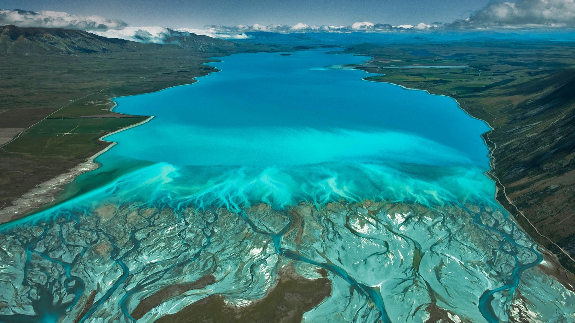
Lake Tekapo, New Zealand
The striking electric-blue waters of Lake Tekapo are caused by extremely finely ground rock particles suspended in the melted waters of glaciers in the nearby Southern Alps. Snowmelt from the range feeds two similarly stunning lakes in the Mackenzie Basin of New Zealand's South Island, Lake Pukaki and Lake Ohau, which share their neighbor's remarkable turquoise color and mountainous backdrops. New Zealand's highest peak, Aoraki/Mount Cook, reigns in Mount Cook National Park, seen in the background of this image.
The name Tekapo is a misspelling of the Māori word Takapō, which means 'to leave in haste at night.' But if you are one of the region's many visitors, you may find the nighttime even more mesmerizing than the day. Lake Tekapo is a certified Dark Sky Reserve, one of the world's largest. With night skies almost completely free of light pollution, stargazing doesn't get much more vibrant, and tours cater to manuhiri (visitors) interested in astro-tourism. If that's not reason enough to stay the night, the area's abundant skiing and fishing opportunities might be. There's certainly no need to leave in a rush.
新西兰特卡波湖
特卡波湖惊人的电蓝色海水是由悬浮在附近南阿尔卑斯山冰川融化水中的极细的岩石颗粒造成的。来自该山脉的融雪为新西兰南岛麦肯齐盆地的两个同样令人惊叹的湖泊——普卡基湖和奥豪湖提供了水源,这两个湖泊共享着其邻居引人注目的绿松石色和多山的背景。新西兰最高峰奥拉基/库克山位于库克山国家公园,如图背景所示。
Tekapo这个名字是毛利人单词Takapō的拼错,意思是“晚上匆忙离开”但如果你是该地区众多游客中的一员,你可能会发现夜间比白天更迷人。特卡波湖是世界上最大的黑天空保护区之一。由于夜空几乎完全没有光污染,观星活动也没有变得更加活跃,旅游也迎合了对天文旅游感兴趣的游客。如果这还不足以作为过夜的理由,那么该地区丰富的滑雪和钓鱼机会可能会更大。当然没有必要匆忙离开。
冰川湾国家公园里的兰普鲁冰川,美国阿拉斯加州 Lamplugh Glacier in Glacier Bay National Park, Alaska (© Andrew Peacock/Getty Images)
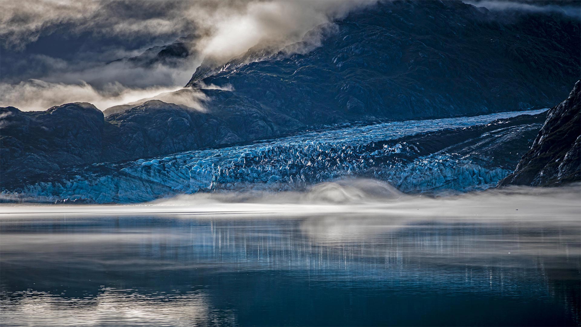
冰川湾国家公园里的兰普鲁冰川,美国阿拉斯加州 Lamplugh Glacier in Glacier Bay National Park, Alaska (© Andrew Peacock/Getty Images)
古老的冰川与大海相遇的地方 Where ancient ice meets the sea
Glacier Bay National Park and Preserve
Think of this special spot as the place where two different Alaskas meet—its vast icy north and its verdant maritime south. Glacier Bay is named for this area's dominant feature, the rivers of ice that carve the landscape and periodically calve icebergs into the sea. On February 26, 1925, President Calvin Coolidge declared much of the land around the bay a national monument. But the protected area was greatly expanded in 1980, when a 3.3-million-acre expanse of glaciers, fjords, rainforest, coastline, and mountain peaks was named a national park and preserve.
Pictured here is Lamplugh Glacier, one of the relatively few tidewater glaciers in the park; the vast majority are found inland. Lamplugh is known for its intense blue color—ice and water absorb the red wavelength of white light and transmit blue light, which is what we end up seeing. The thicker and more pure the ice, the more blue it appears.
冰川湾国家公园
把这个特殊的地方想象成两个不同的阿拉斯加人在广阔的冰雪覆盖的北方和苍翠的海洋南面相遇的地方。冰川湾是以该地区的主要特征命名的,冰的河流切割景观,并周期性地将冰山崩解入海中。1925年2月26日,卡尔文·柯立芝总统宣布海湾周围的大部分土地为国家纪念碑。但1980年,保护区得到了极大的扩展,当时一片330万英亩的冰川、峡湾、雨林、海岸线和山峰被命名为国家公园和保护区。
这里的图片是兰普卢冰川,公园里相对较少的潮水冰川之一;绝大多数是在内陆发现的。Lamplugh以其强烈的蓝色而闻名,冰和水吸收白光的红色波长并传输蓝光,这就是我们最终看到的。冰越纯,越厚。
克卢恩国家公园保护区的山脉和冰川,加拿大育空地区 Saint Elias Mountains and Kaskawulsh Glacier in Kluane National Park and Reserve, Yukon, Canada (© Design Pics Inc/Alamy)
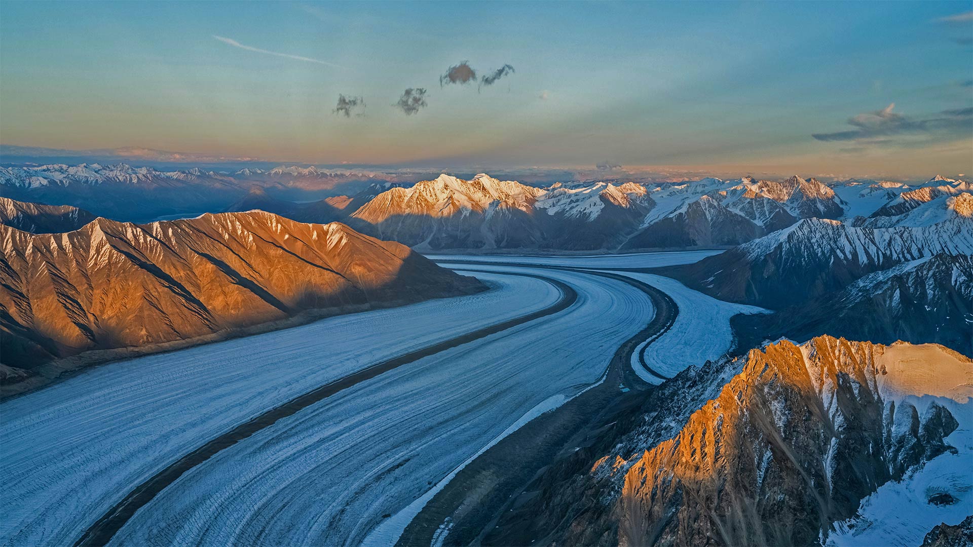
克卢恩国家公园保护区的山脉和冰川,加拿大育空地区 Saint Elias Mountains and Kaskawulsh Glacier in Kluane National Park and Reserve, Yukon, Canada (© Design Pics Inc/Alamy)
Kluane National Park
What looks here like an ice road for 50-foot-tall truckers is really Kaskawulsh Glacier in Canada's Kluane National Park. This corner of the Yukon is home to the largest ice field on Earth outside of the poles, with the slow, steady flow of more than 2,000 glaciers continually carving these vast canyons amid the peaks.
Speaking of peaks, glance up and you'll see the Yukon is also paradise for mountain lovers. And Kluane is its pinnacle, literally: Located within the park is Mount Logan, the highest mountain in Canada (and second-highest on the continent after Alaska's Denali).
库隆尼国家公园
对于50英尺高的卡车司机来说,这里看起来像是一条冰路,实际上是加拿大克鲁恩国家公园中的卡斯卡沃尔什冰川。育空地区的这个角落是地球上除极地以外最大的冰原的所在地,2000多条缓慢而稳定的冰川不断地在山峰之间雕刻着这些巨大的峡谷。
说到山峰,抬头一看,你会发现育空地区也是高山爱好者的天堂。Kluane是它的巅峰,字面意思是:位于公园内的是加拿大最高的山脉洛根山(仅次于阿拉斯加的德纳利山,是该大陆第二高的山)。
蓝山国家公园里的萤火虫,澳大利亚 Glowworms in Blue Mountains National Park, Australia (© Leelakajonkij/Getty Images)
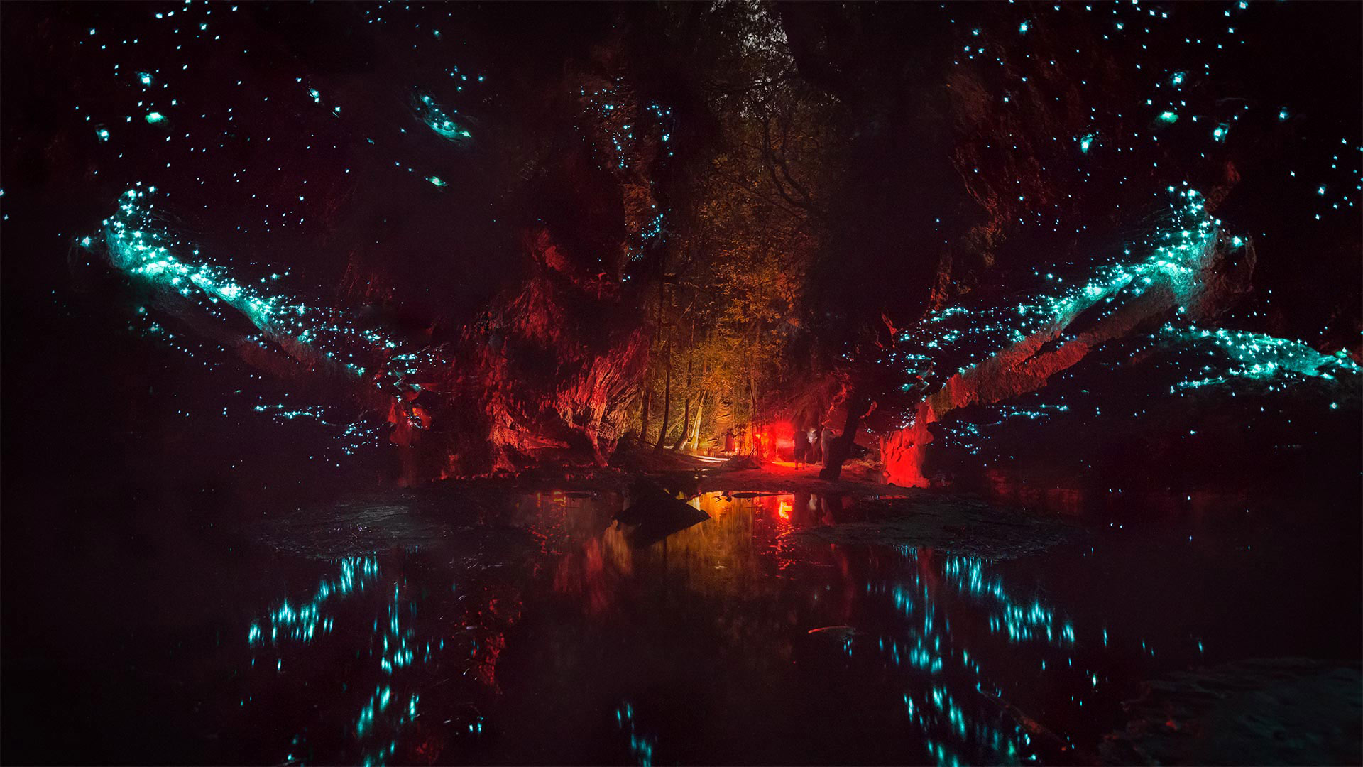
蓝山国家公园里的萤火虫,澳大利亚 Glowworms in Blue Mountains National Park, Australia (© Leelakajonkij/Getty Images)
Glowworm caves in Australia
Down under the land in the Land Down Under, cave explorers may find these subterranean spaces illuminated by an unlikely light source. Fungus gnat larvae—more affectionately known as glowworms—speckle the walls and ceilings of caverns here in Australia during the warm season from December to March. To humans they're hypnotizingly harmless and add a little otherworldly charm to the caves in such places as Blue Mountains National Park, as seen in our photo. But if you're a fly or mosquito, beware! Glowworms dangle tiny, sticky silk strands that ensnare winged insects flying toward what looks like a starry night sky, but is in fact the cave ceiling, covered in glowworms, patiently waiting to reel in a deceived fly.
澳大利亚的萤火虫洞穴
在地下,洞穴探险家可能会发现这些地下空间被一种不太可能的光源照亮。在12月至3月的温暖季节,真菌小昆虫幼虫(更亲切地称为萤火虫)在澳大利亚洞穴的墙壁和天花板上散布斑点。在我们的照片中可以看到,对人类来说,它们无害得令人着迷,为蓝山国家公园等地的洞穴增添了一点超凡脱俗的魅力。但如果你是一只苍蝇或蚊子,小心!萤火虫悬挂着细小的、粘乎乎的丝线,诱捕着飞向星空的有翼昆虫,但事实上是洞穴的天花板,上面覆盖着萤火虫,耐心地等待着一只受骗的苍蝇。
有着丰富石化木材的石化林国家公园,美国亚利桑那州 Petrified Forest National Park, Arizona (© Ian Shive/Tandem Stills + Motion)
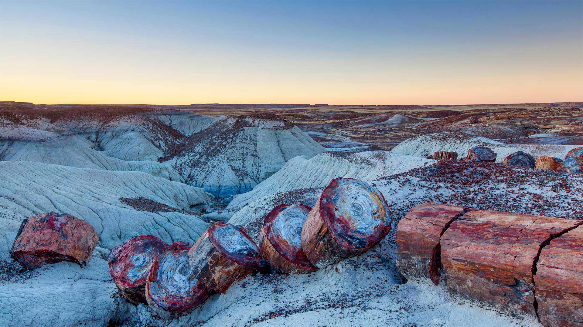
有着丰富石化木材的石化林国家公园,美国亚利桑那州 Petrified Forest National Park, Arizona (© Ian Shive/Tandem Stills + Motion)
Petrified Forest National Park
The burliest lumberjack with the best-oiled chainsaw couldn't slice the massive 'timbers' found in Petrified Forest National Park. So why are these giant stone logs segmented in such symmetrical stumps?
Each of these smooth splits occurred in an instant as the brittle quartz cracked under geologic pressure. But each of those instants was eons in the making. First, 225 million years ago, the trees were buried by torrents of river silt. Then mineral deposits slowly seeped into the trees and replaced the decaying wood. Much later, around 60 million years ago, the entire Colorado Plateau began shifting, generating crushing forces that finally divided the petrified logs.
The fossilized trees, surrounding land, and the many plants and animals that live here have enjoyed protection since December 8, 1906, when President Theodore Roosevelt created Petrified Forest National Monument. It was designated as a national park in 1962, lending still greater protection.
石化森林国家公园
最结实的伐木工人和最好的油锯无法切割石化森林国家公园中发现的巨大“木材”。那么,为什么这些巨石原木被分割成如此对称的树桩呢?
当脆性石英在地质压力下破裂时,每一个光滑的裂缝都会在瞬间发生。但是,每一个瞬间都在酝酿中。首先,2.25亿年前,这些树木被河流淤泥的洪流所掩埋。然后,矿物质慢慢渗入树木,取代了腐烂的木材。很久以后,大约6000万年前,整个科罗拉多高原开始移动,产生了最终分裂石化原木的压碎力。
自1906年12月8日西奥多·罗斯福总统创建石化森林国家纪念碑以来,这里的树木化石、周围的土地和许多动植物一直受到保护。1962年,它被指定为国家公园,提供了更大的保护。
史诺多尼亚国家公园的Capel Curig,英国威尔士 Capel Curig in Snowdonia National Park, Wales, United Kingdom (© Sebastian Wasek/Sime/eStock Photo)
史诺多尼亚国家公园的Capel Curig,英国威尔士 Capel Curig in Snowdonia National Park, Wales, United Kingdom (© Sebastian Wasek/Sime/eStock Photo)
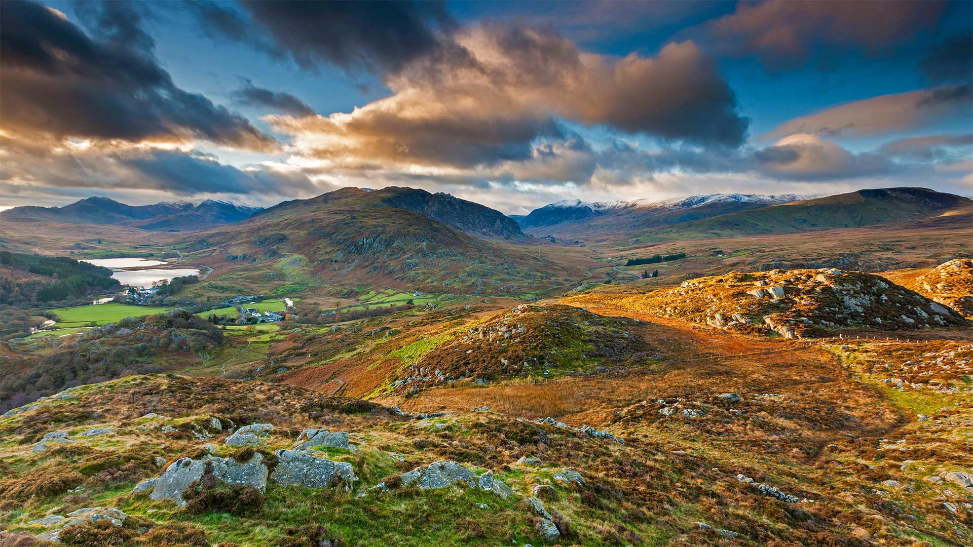
A Welsh wonder turns 70
Here on the west coast of Great Britain, we're enjoying views of the windswept uplands and jagged peaks that surround the small village of Capel Curig in the heart of Snowdonia National Park. Renowned for its rugged and mountainous landscape, Snowdonia is the largest national park in Wales and home to over 26,000 people—and even more sheep—the wooly farm animals outnumber people three to one in Wales. About 60% of the park's population speak Welsh, one of Europe's oldest languages, and today they will be wishing this spectacular setting a 'pen-blwydd hapus' (happy birthday) as Snowdonia celebrates its 70th anniversary.
Established on October 18, 1951 as the first national park in Wales, Snowdonia boasts nine mountain ranges that cover just over half the park's 823 square miles. Its most popular peak is Snowdon (Yr Wyddfa in the local Welsh tongue), the tallest mountain in Wales and England, which you can see in the background of our photo. At 3,560 feet, Snowdon is one of 15 mountains within the park that top 3,000 feet, and they're clustered close enough together to make it possible to reach all 15 summits within 24 hours, a challenge known as the Welsh 3000s.
威尔士奇迹70岁
在英国西海岸,我们可以欣赏到斯诺多尼亚国家公园中心的卡佩尔·库里小村庄周围被风吹过的高地和参差不齐的山峰。斯诺登尼亚以其崎岖多山的景观而闻名,是威尔士最大的国家公园,居住着26000多人,甚至更多的绵羊。在威尔士,羊毛农场动物的数量比人多三倍。大约60%的公园人口讲威尔士语,威尔士语是欧洲最古老的语言之一。今天,在斯诺多尼亚庆祝其70周年之际,他们将祝愿这一壮观的场景成为“彭·布吕德·哈布斯”(生日快乐)。
斯诺登尼亚于1951年10月18日建立,是威尔士的第一个国家公园,拥有九座山脉,占地823平方英里,略超过公园面积的一半。它最受欢迎的山峰是斯诺登(当地威尔士语中的Yr Wyddfa),这是威尔士和英格兰最高的山峰,你可以在我们的照片背景中看到。斯诺登海拔3560英尺,是公园内海拔3000英尺的15座山峰之一,它们聚集在一起,足以在24小时内到达所有15座山峰,这一挑战被称为威尔士3000山脉。
拉莫里斯国家公园中的Wapizagonke湖区,加拿大魁北克 The Wapizagonke Lake in La Mauricie National Park, Quebec, Canada (© Instants/Getty Images)
拉莫里斯国家公园中的Wapizagonke湖区,加拿大魁北克 The Wapizagonke Lake in La Mauricie National Park, Quebec, Canada (© Instants/Getty Images)
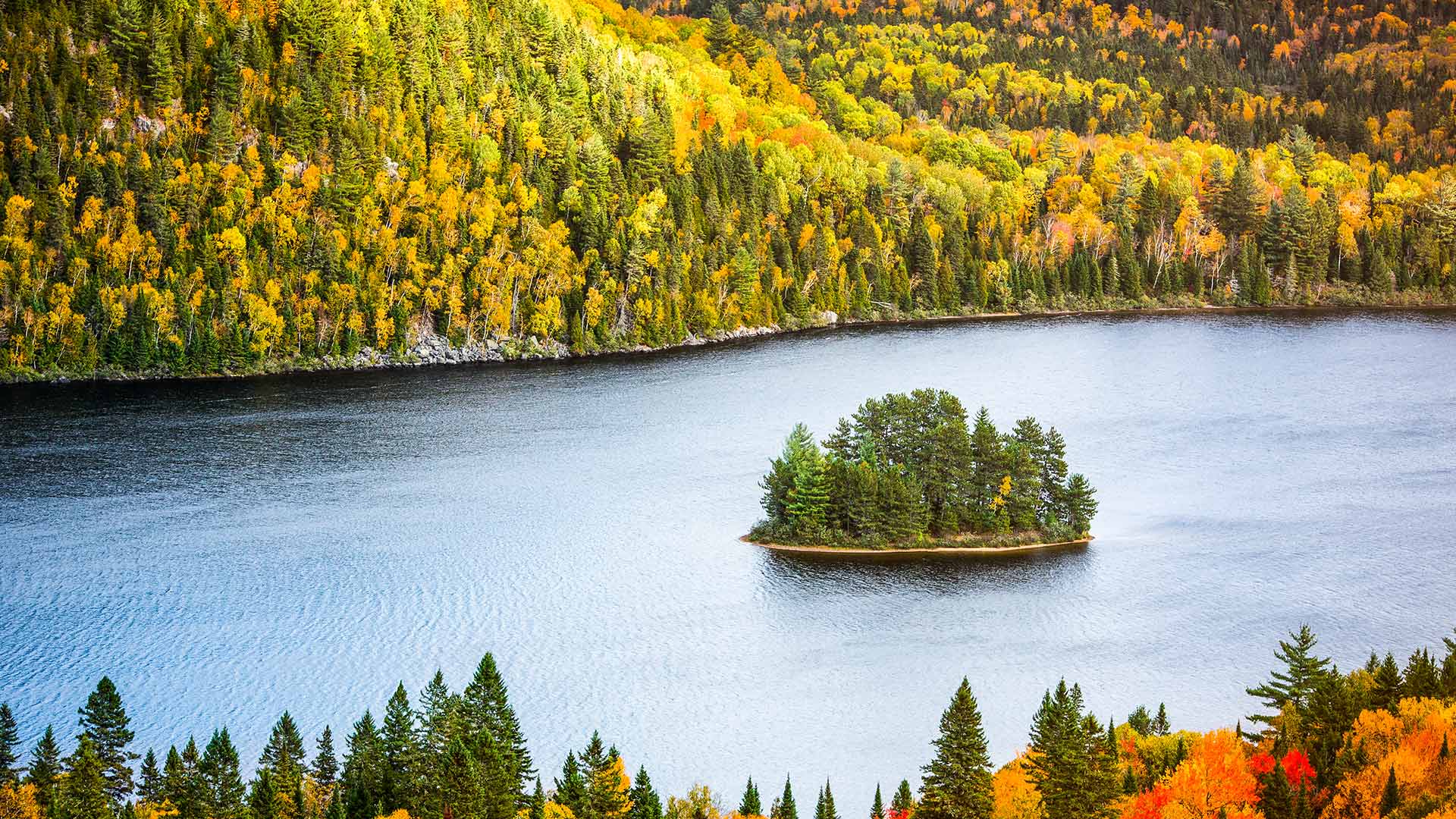
Vibrant colours of Fall
This majestic view of the Wapizagonke Lake encapsulates the spirit of autumn through the vibrant display of colours. Located between Québec City and Montréal, La Mauricie National Park is a site for all types of nature lovers. The park offers activities such as hiking, kayaking, paddling, bird watching, ice climbing and even star gazing. With more than 150 lakes and home to one of the oldest mountain ranges – the Laurentian Mountains - La Mauricie National Park is a destination filled with spectacular vistas all-year-round.
秋天的鲜艳色彩
瓦皮扎贡克湖的壮丽景色通过生动的色彩展示,体现了秋天的精神。La Mauricie国家公园位于魁北克市和蒙特勒尔之间,是各类自然爱好者的聚集地。公园里有徒步旅行、皮划艇、划船、观鸟、攀冰,甚至还有观星等活动。拉莫里西国家公园拥有150多个湖泊,是最古老的山脉之一——劳伦斯山脉的所在地,是一个终年景色壮观的目的地。