标签 国家公园 下的文章
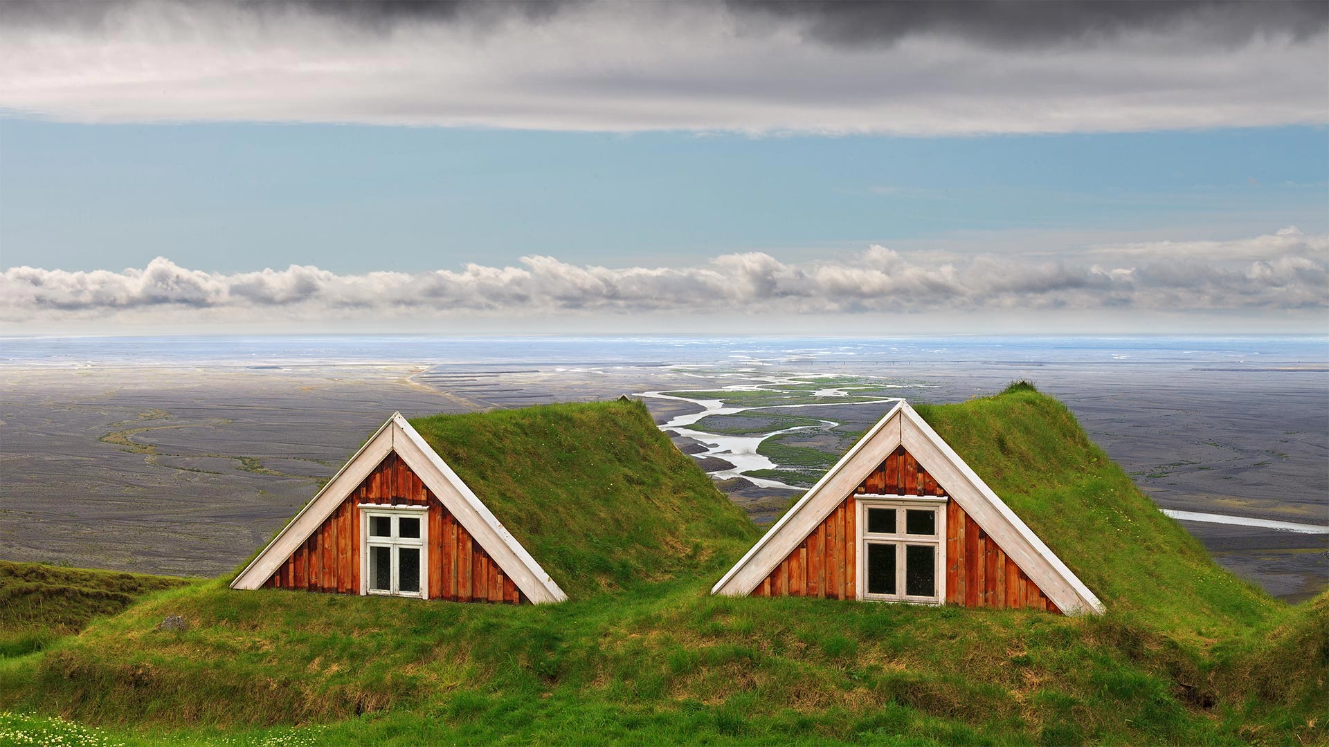
斯卡夫塔山中的传统农舍,冰岛瓦特纳冰川国家公园 Traditional farmhouses at Skaftafell, Vatnajökull National Park, Iceland (© Jarcosa/Getty Images)
斯卡夫塔山中的传统农舍,冰岛瓦特纳冰川国家公园 Traditional farmhouses at Skaftafell, Vatnajökull National Park, Iceland (© Jarcosa/Getty Images)
Tough turf
Roofs of sod have sheltered mainland Scandinavians through countless winters and summers. But those who migrated from Norway's grass-roof log cabins to this Icelandic tundra in the 9th century found none of the rich timberland of their homeland—just wispy birch forests and grassy fields. To survive the cold, they took the old turf roof concept and built on it, encasing not only the roofs but the walls of their birch-framed homes in layers of living, insulating soil.
The turf buildings shown here are located at Skaftafell, a manor farm founded by early settlers and now part of Vatnajökull National Park. Unlike Icelanders' history, though, these huts aren't a millennium old: They date to the 19th century, when the plains in the distance began flooding and the farmers who'd made homes there were forced uphill.
坚硬的草皮
草皮屋顶遮蔽了斯堪的纳维亚大陆无数的冬夏。但是,那些在9世纪从挪威的草屋顶木屋迁移到冰岛苔原的人发现,他们的祖国没有一片富饶的林地,只有一望无际的桦树林和草地。为了在寒冷中生存,他们采用了旧的草皮屋顶概念,并在其上建造,不仅将屋顶,而且将桦木结构房屋的墙壁包裹在一层活的绝缘土壤中。
这里展示的草皮建筑位于斯卡塔菲尔,这是一个由早期定居者建立的庄园农场,现在是瓦特纳科尔国家公园的一部分。不过,与冰岛人的历史不同的是,这些小屋并没有千年的历史:它们可以追溯到19世纪,当时远处的平原开始泛滥,在那里建房的农民被迫上山。
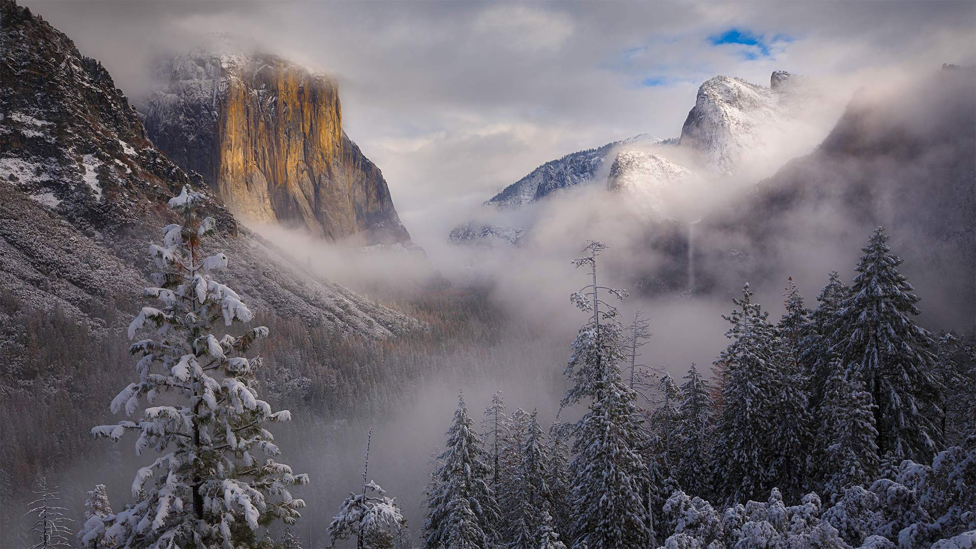
暴风雪散去,加利福尼亚优胜美地国家公园 Clearing snowstorm, Yosemite National Park, California (© Jeff Lewis/Tandem Stills + Motion)
暴风雪散去,加利福尼亚优胜美地国家公园 Clearing snowstorm, Yosemite National Park, California (© Jeff Lewis/Tandem Stills + Motion)
Ansel Adams' enduring vision
Of all the camera-wielding luminaries who've snapped this eastward view of Yosemite Valley, few can hold a 'candela' to Ansel Adams, born this day in 1902. The legendary photographer of Western landscapes was given his first camera here in Yosemite as a boy. The national park was his favorite place in the world, and he returned every year for the rest of his life.
Adams' style is one of the most recognizable in photography: Bright whites against deep blacks, with high horizon lines that leave most of the frame filled with landscape, a narrow lens aperture placing every tiny detail in biting focus. Unlike many photographers of the day who considered themselves more journalist than artist, Adams was a visionary: Instead of plainly documenting what he saw, Adams aimed to convey the enchantment, awe, and terror his beloved landscapes made him feel, spending hours in the darkroom fine-tuning exposures to match what he visualized. 'Clearing Winter Storm'—the photo that today's image pays tribute to—was taken around 1937, depicting ominous clouds gathering around El Capitan and Bridalveil Fall, whiting out the distant peak of Half Dome.
While Adams had to lug bulky box cameras and light meters into the wilderness to capture his vision, chances are you've got the whole setup in your pocket. Why not grab that phone of yours, venture outside, and celebrate this legendary shutterbug's birthday with some masterful nature snaps of your own?
安塞尔·亚当斯的不朽愿景
在所有手持相机拍摄到约塞米蒂山谷东面景色的名人中,很少有人能为1902年出生的安塞尔·亚当斯(Ansel Adams)奉上“烛台”。这位西方风景的传奇摄影师小时候在约塞米蒂得到了他的第一台相机。国家公园是他在世界上最喜欢的地方,他余生每年都会回来。
亚当斯的风格是摄影界公认的最具代表性的风格之一:明亮的白色与深黑的对比,高水平的线条让大部分画面充满了风景,狭窄的镜头光圈将每一个微小的细节都置于扣人心弦的焦点。与当时许多认为自己更像记者而不是艺术家的摄影师不同,亚当斯是一个有远见的人:他没有简单地记录他所看到的一切,而是致力于传达他所钟爱的风景带给他的魅力、敬畏和恐惧,他花了数小时在暗室微调曝光,以符合他所想象的《清冬风暴》(Clearing Winter Storm)——这张今天的照片是在1937年左右拍摄的,描绘了不祥的云层聚集在埃尔卡皮坦(El Capitan)和布里达尔维尔瀑布(Bridalveil Fall)周围,使远处的半圆顶峰黯然失色。
虽然亚当斯不得不拖着笨重的盒式摄像机和测光表到荒野中捕捉他的视野,但你很可能已经把整个设置都放在口袋里了。为什么不拿起你的手机,到外面去冒险,用你自己掌握的自然快照来庆祝这个传奇的shutterbug的生日呢?
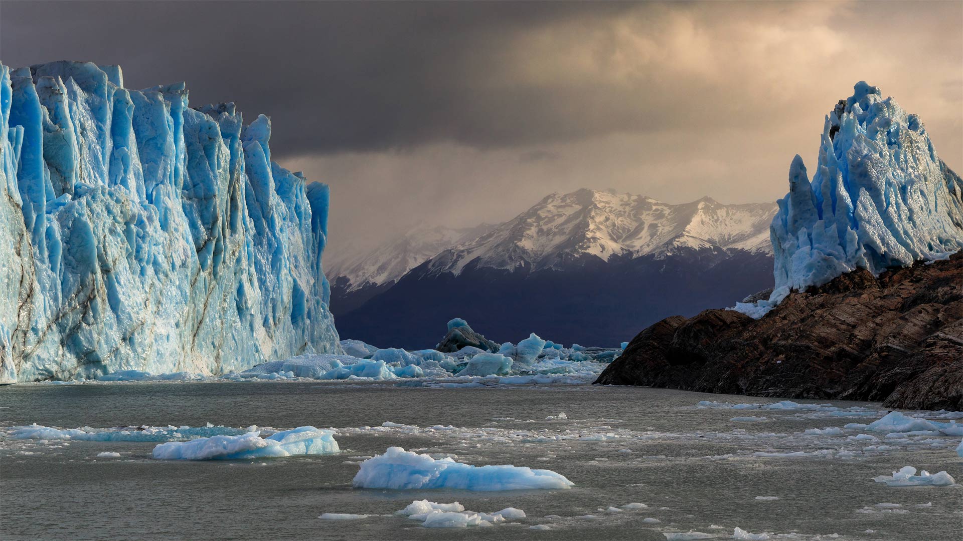
冰川国家公园中的佩里托莫雷诺冰川,阿根廷 Perito Moreno Glacier in Patagonia's Los Glaciares National Park, Argentina (© Juergen Schonnop/Getty Images)
冰川国家公园中的佩里托莫雷诺冰川,阿根廷 Perito Moreno Glacier in Patagonia's Los Glaciares National Park, Argentina (© Juergen Schonnop/Getty Images)
The persistence of Perito Moreno
Yes, it's true that glaciers are shrinking, but not all of them. Perito Moreno, a low-lying glacier in southern Argentina, accumulates ice at about the same rate that it melts into chilly Argentino Lake. This equilibrium makes it one of the few glaciers worldwide that aren't losing mass to climate change.
Perito Moreno is an Argentine icon, partly for its unusual accessibility via the lake, the largest within the nation. Visitors to Los Glaciares National Park can boat or kayak out on ice-blue water for a better look—but they need to keep a safe distance as icebergs constantly calve from the glacier's face, creating huge splashes and waves.
佩里托·莫雷诺的坚持
是的,冰川确实在缩小,但不是全部。阿根廷南部的一座低洼冰川佩里托莫雷诺(Perito Moreno)积冰的速度与它融化到寒冷的阿根廷湖的速度差不多。这种平衡使它成为全球为数不多的不会因气候变化而失去质量的冰川之一。
佩里托·莫雷诺是阿根廷的一个标志,部分原因是它通过这个国家最大的湖泊不同寻常的可达性。到洛斯冰川国家公园的游客可以在冰蓝色的水面上划船或皮划艇,以获得更好的观赏效果,但他们需要保持安全距离,因为冰山不断地从冰川表面脱落,形成巨大的水花和海浪。
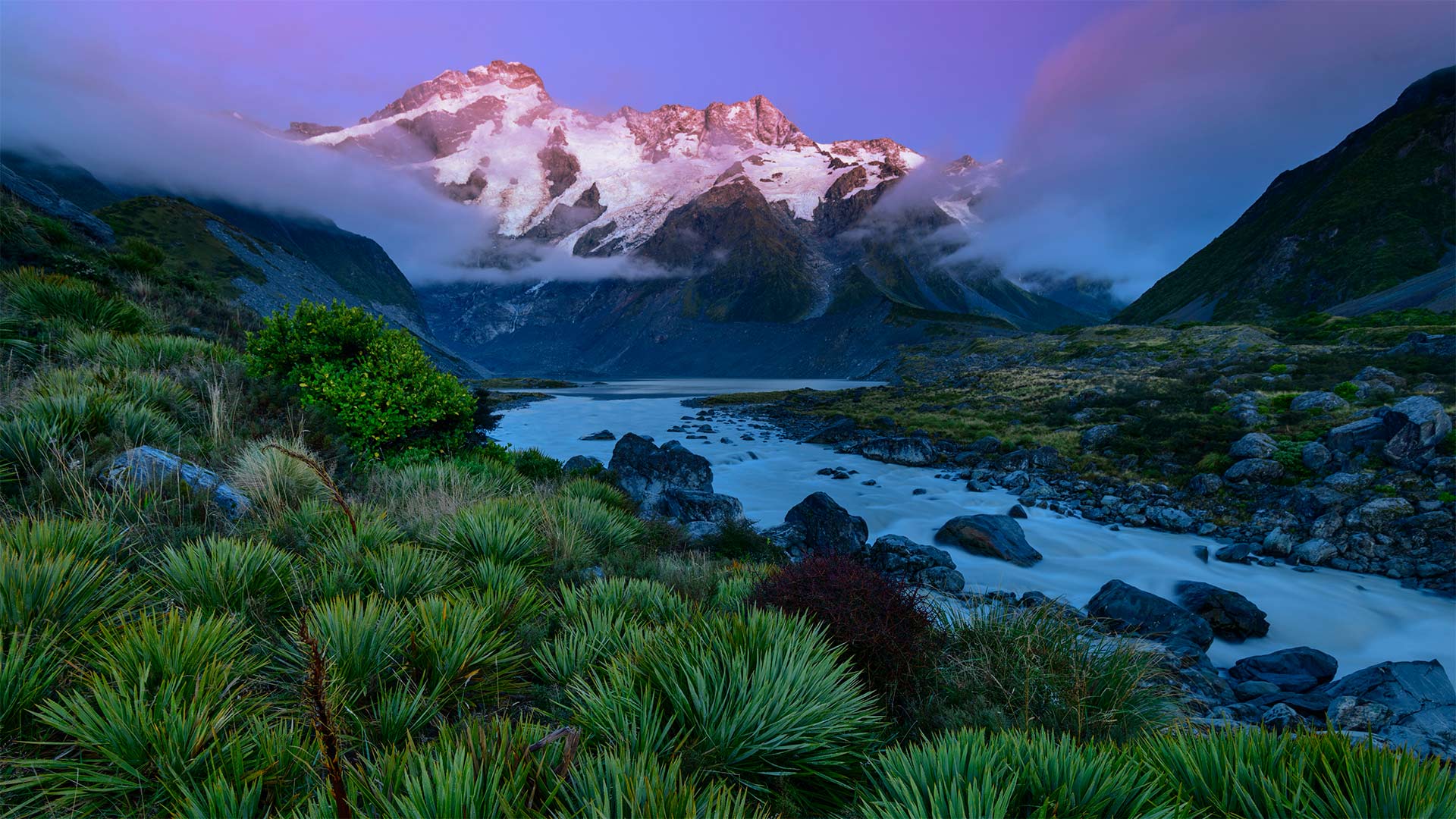
奥拉基库克山国家公园中的塞夫顿山,新西兰南岛 Mount Sefton in Aoraki/Mount Cook National Park, South Island, New Zealand (© AWL Images/Danita Delimont)
奥拉基库克山国家公园中的塞夫顿山,新西兰南岛 Mount Sefton in Aoraki/Mount Cook National Park, South Island, New Zealand (© AWL Images/Danita Delimont)
Where is this gorgeous peak?
This spectacular landscape might just be the perfect place to celebrate Waitangi Day, New Zealand's national holiday. It commemorates the 1840 treaty between Britain and some 500 Māori chiefs that established British law in the island nation. The Treaty of Waitangi is considered New Zealand's founding document and a cornerstone in the country's history. Another important legacy of the treaty is that it provided the framework for political relations between New Zealand's government and the indigenous Māori people.
Perhaps nothing symbolizes negotiations between those two parties better than the land you see here, which has been preserved as a national park since 1953. Our image shows the glacier-capped peak of Mount Sefton, one of the many tall mountains here in the Southern Alps. Just a few miles away towers New Zealand's tallest peak, originally called Aoraki by the Māori, who named it after a mythological figure. The mountain was given its English name, Mount Cook, in 1851, in honor of Captain James Cook, the British explorer who circumnavigated and mapped the country in the 1770s. An agreement in 1998 between the government and Māori leaders officially renamed both the peak and the park to Aoraki/Mount Cook. It's one of the few renamed areas in New Zealand where the Māori name precedes the English.
这座美丽的山峰在哪里?
这片壮观的风景可能正是庆祝新西兰国庆日怀唐日的最佳场所。它纪念1840年英国与大约500名毛利人酋长签订的条约,该条约确立了英国在这个岛国的法律。《怀唐伊条约》被认为是新西兰的创始文件和国家历史的基石。该条约的另一个重要遗产是,它为新西兰政府与土著毛利人之间的政治关系提供了框架。
也许没有什么比你在这里看到的这块土地更能代表两党之间的谈判了,这块土地自1953年以来一直被保留为国家公园。我们的图片显示了塞夫顿山冰川覆盖的山峰,它是阿尔卑斯山脉南部众多高山之一。就在几英里远的地方,矗立着新西兰最高的山峰,毛利人最初称之为Aoraki,以一个神话人物的名字命名。1851年,为了纪念英国探险家詹姆斯·库克上尉(James Cook),这座山被命名为库克山(Mount Cook),詹姆斯·库克上尉于1770年代环游并绘制了该国地图。1998年,政府与毛利人领导人达成协议,正式将山顶和公园更名为Aoraki/Mount Cook。这是新西兰为数不多的几个更名地区之一,毛利人的名字先于英语。
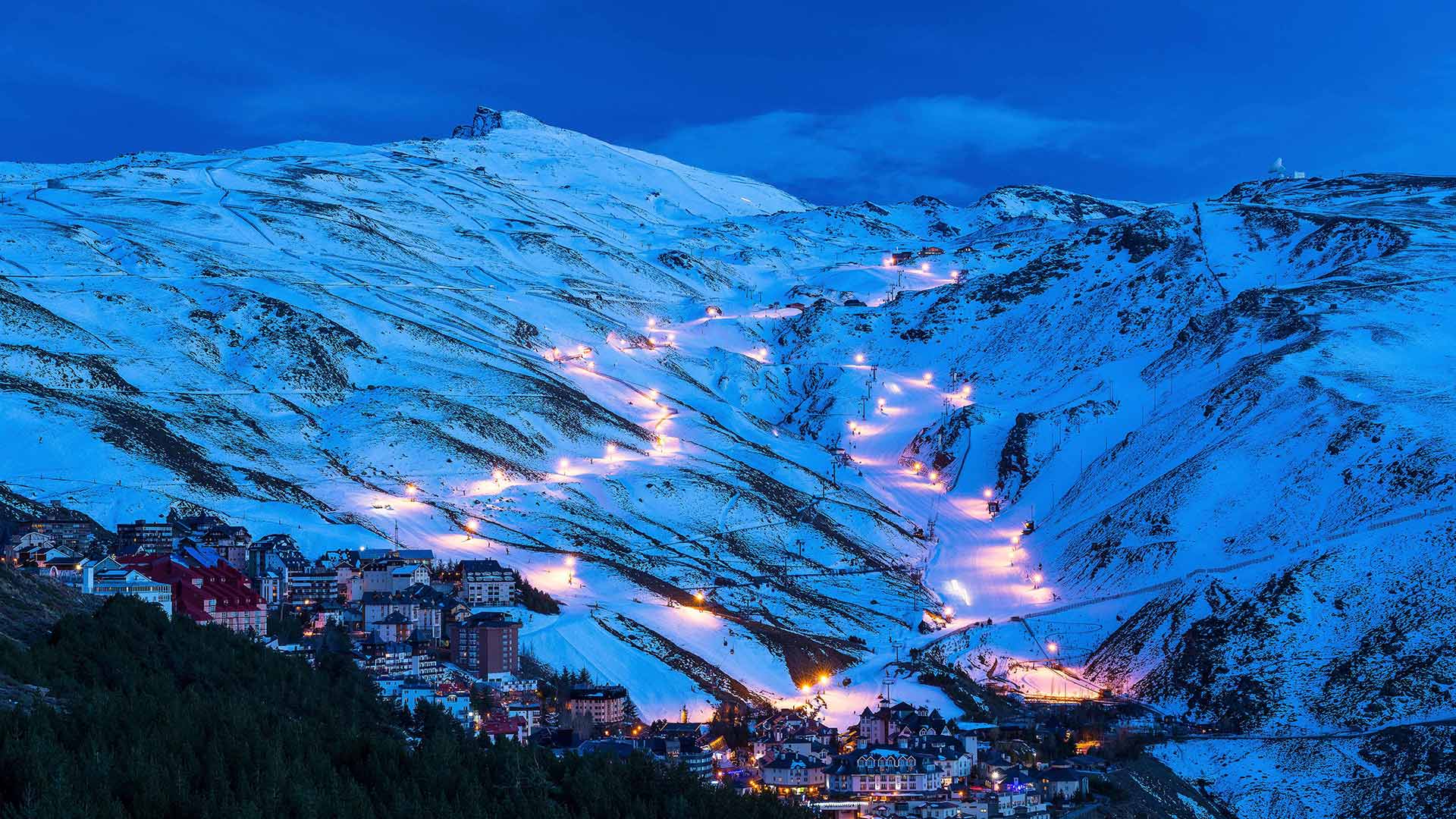
Pradollano滑雪站,西班牙内华达山脉国家公园 (© NTCo/iStock/Getty Images Plus)
峰牙-己榜国家公园中的韩松洞,越南 Sơn Đoòng cave in Phong Nha-Kẻ Bàng National Park, Vietnam (© David A Knight/Shutterstock)
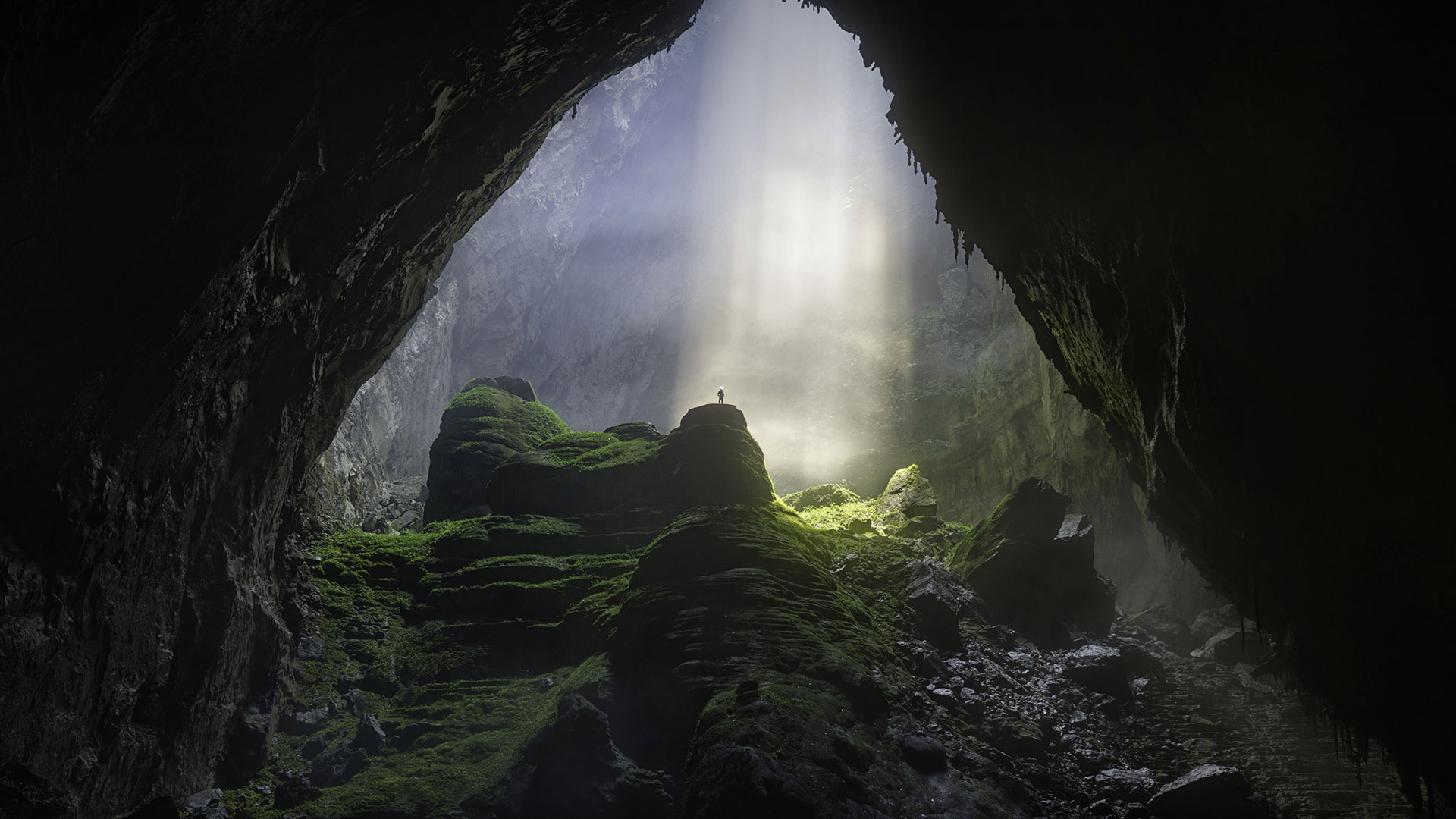
峰牙-己榜国家公园中的韩松洞,越南 Sơn Đoòng cave in Phong Nha-Kẻ Bàng National Park, Vietnam (© David A Knight/Shutterstock)
A universe underground
When Vietnamese farmer Hồ Khanh stumbled upon this cave in 1991, it was immediately clear the gaping mouth led to a huge, dark, untouched chamber, complete with a free-flowing underground river. What couldn't have been clear to him then was that this cave, now known as Sơn Đoòng, is by far the world's largest in volume.
Lacking gear to explore the cave further, Khanh could only wander back home and tell friends about his discovery. But he was unable to retrace his steps to the cavern, his tracks engulfed by the jungle. Relegated to rumor, the cave went unexplored for almost two decades until a visiting team of British cavers caught wind of Khanh's tale. In 2009, Khanh led them to Sơn Đoòng after a long search, and explorations commenced that found the cave was vast beyond anyone's expectations.
Sơn Đoòng is over 1.5 billion cubic feet in volume, with its main chamber 650 feet high, almost 500 feet wide, and stretching more than 3 miles, large enough to fly a Boeing 747 through—but look out for the 15-story stalagmites. One of the cave's massive dolines—sunken, sun-exposed sections like the one seen here—hosts an entire rainforest ecosystem. And that's just what we know so far: Cave divers have yet to fully explore Sơn Đoòng's subterranean river, and vast passages found as recently as 2019 have only added to what's known of the cave's enormity.
地下的宇宙
1991年,当越南农民HồKhanh偶然发现了这个洞穴时,人们立刻清楚地看到,张开的洞口嘴通向一个巨大的、黑暗的、未被触及的洞穴,里面有一条自由流动的地下河。当时他不清楚的是,这个洞穴,现在被称为SơnĐoòng,是迄今为止世界上最大的洞穴。
由于缺乏进一步探索洞穴的装备,卡恩只能漫步回家,告诉朋友他的发现。但他无法回到洞穴,他的足迹被丛林吞噬。由于流言蜚语的影响,这个洞穴在近20年的时间里一直未被发现,直到一队英国探洞者闻到了卡恩的故事。2009年,Khanh带领他们经过长时间的搜寻,来到了SơnĐoòng,开始了探险,发现这个洞穴的面积超出了任何人的预期。
SơnĐoòng的体积超过15亿立方英尺,其主舱室高650英尺,宽近500英尺,长度超过3英里,足以让一架波音747飞机通过,但要注意15层楼高的石笋。洞穴中一条巨大的低谷下陷,暴露在阳光下,就像这里看到的一样,这里有一个完整的雨林生态系统。而这正是我们目前所知道的:洞穴潜水员还没有完全探索sơnĐoòng的地下河,而最近在2019年发现的巨大通道只是增加了人们所知的洞穴的巨大性。
布莱斯峡谷国家公园的冬天,犹他州 Winter in Bryce Canyon National Park, Utah (© Don Paulson/Danita Delimont)
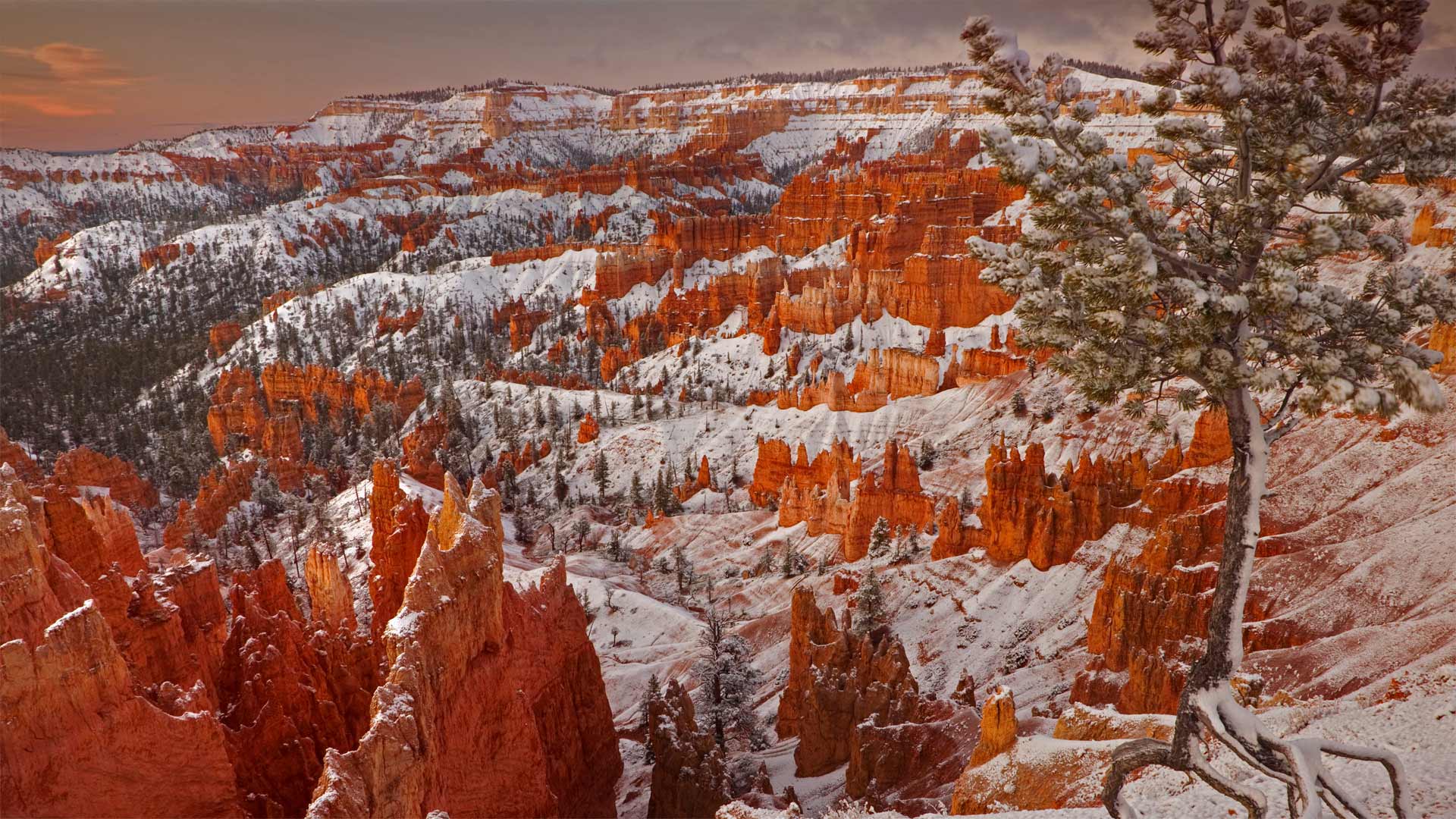
布莱斯峡谷国家公园的冬天,犹他州 Winter in Bryce Canyon National Park, Utah (© Don Paulson/Danita Delimont)
Winter in the Wild West
When considering the dramatically eroded canyons of southwestern Utah, snow may not be the first thing that comes to mind. But far-flung Bryce Canyon National Park gets plenty of the white stuff, owing to its elevation of 8,000-plus feet at the massive amphitheater's rim. The cold not only provides scenic snowy views and great cross-country skiing, it's responsible for the striking red-rock pinnacles—known as hoodoos—that make the park so unique.
High above sea level, winter in Bryce Canyon often sees daily shifts between freezing and above-freezing temperatures. Despite its name, Bryce Canyon isn't a true canyon, but is instead a collection of natural amphitheaters. The park's hoodoos formed as water seeped into massive stone plateaus, then froze and expanded to break away chunks of rock. Repeated day after day for eons, this process has left slim sections of sediment standing throughout Bryce Canyon—now the largest concentration of hoodoos in the world.
狂野西部的冬天
在说到犹他州西南部峡谷为什么受侵蚀严重时,降雪可能并不是第一个被想到的原因。 但是遥远的布莱斯峡谷国家公园(Bryce Canyon National Park)由于在大型圆形剧场的边缘海拔超过8,000英尺而获得了很多白色的东西。 寒冷不仅带来优美的雪景和越野滑雪,而且还造成了令人惊叹的红岩峰(称为石林),使公园如此独特。
布莱斯峡谷的冬天海拔很高,每天都会出现冰点和冰点以上温度的变化。尽管它的名字包含峡谷,但布莱斯峡谷不是一个真正的峡谷,而是一个自然露天剧场的集合。公园的石林随着水渗入巨大的石制高原而形成,然后冻结并扩大以分裂成块的岩石。 这一过程日复一日地重复了亿万年,留下了遍布布莱斯峡谷的薄薄的沉积物,现在布莱斯峡谷是世界上最大的石林聚集地。
易北河上的巴斯泰桥,德国撒克逊瑞士国家公园 Bastei Bridge above the Elbe river in Saxon Switzerland National Park, Germany (© Reinhard Schmid/eStock Photo)
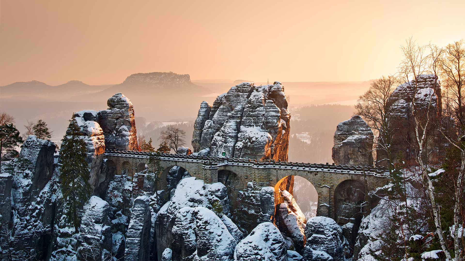
易北河上的巴斯泰桥,德国撒克逊瑞士国家公园 Bastei Bridge above the Elbe river in Saxon Switzerland National Park, Germany (© Reinhard Schmid/eStock Photo)
A bridge that rocks
Sandwiched between soaring pinnacles of sandstone, Bastei Bridge is a highlight of Saxon Switzerland National Park. But don't be fooled by the park's name because we're not in Switzerland; we're hundreds of miles away in eastern Germany, close to the border of the Czech Republic. The name comes from two Swiss artists who visited the area in the second half of the 18th century and felt the picturesque upland scenery was reminiscent of their homeland.
The park boasts untamed forests and spectacular rock formations, including the Bastei in our photo. The rock pillars here were formed by water erosion over a million years ago and tower 636 feet above the Elbe, one of the major rivers in Central Europe. If you're not afraid of heights, you can walk the bridge that has connected these jagged rocks for almost 200 years. Originally made of wood but rebuilt with stone in 1851 to accommodate the increasing tourist traffic, Bastei Bridge offers stunning panoramic views of the river and surrounding Elbe Sandstone Mountains. It also leads to the remains of an ancient castle that once stood here and is now an open-air museum.
岩石桥
巴斯泰桥夹在高耸的砂岩尖顶之间,是撒克逊瑞士国家公园的一大亮点。但不要被公园的名字欺骗了,因为我们不在瑞士;我们在几百英里之外的德国东部,靠近捷克共和国的边界。这个名字来自两位瑞士艺术家,他们在18世纪后半叶造访过这个地区,他们觉得风景如画的高地风景让人想起了他们的家乡。
这个公园拥有未经改造的森林和壮观的岩层,包括我们照片中的巴斯泰。这里的岩柱是由一百万年前的水蚀形成的,耸立在易北河上方636英尺处,易北河是中欧主要河流之一。如果你不怕高,你可以走过这座连接这些参差不齐的岩石将近200年的桥。巴斯泰桥最初是用木头建造的,但在1851年用石头重建,以适应日益增长的游客流量,在它上面可以看到令人惊叹的易北河全景和周围的埃尔贝砂岩山脉的全景。它还通向一座古堡的遗迹,该古堡曾经矗立在这里,现在成为了一座露天博物馆。
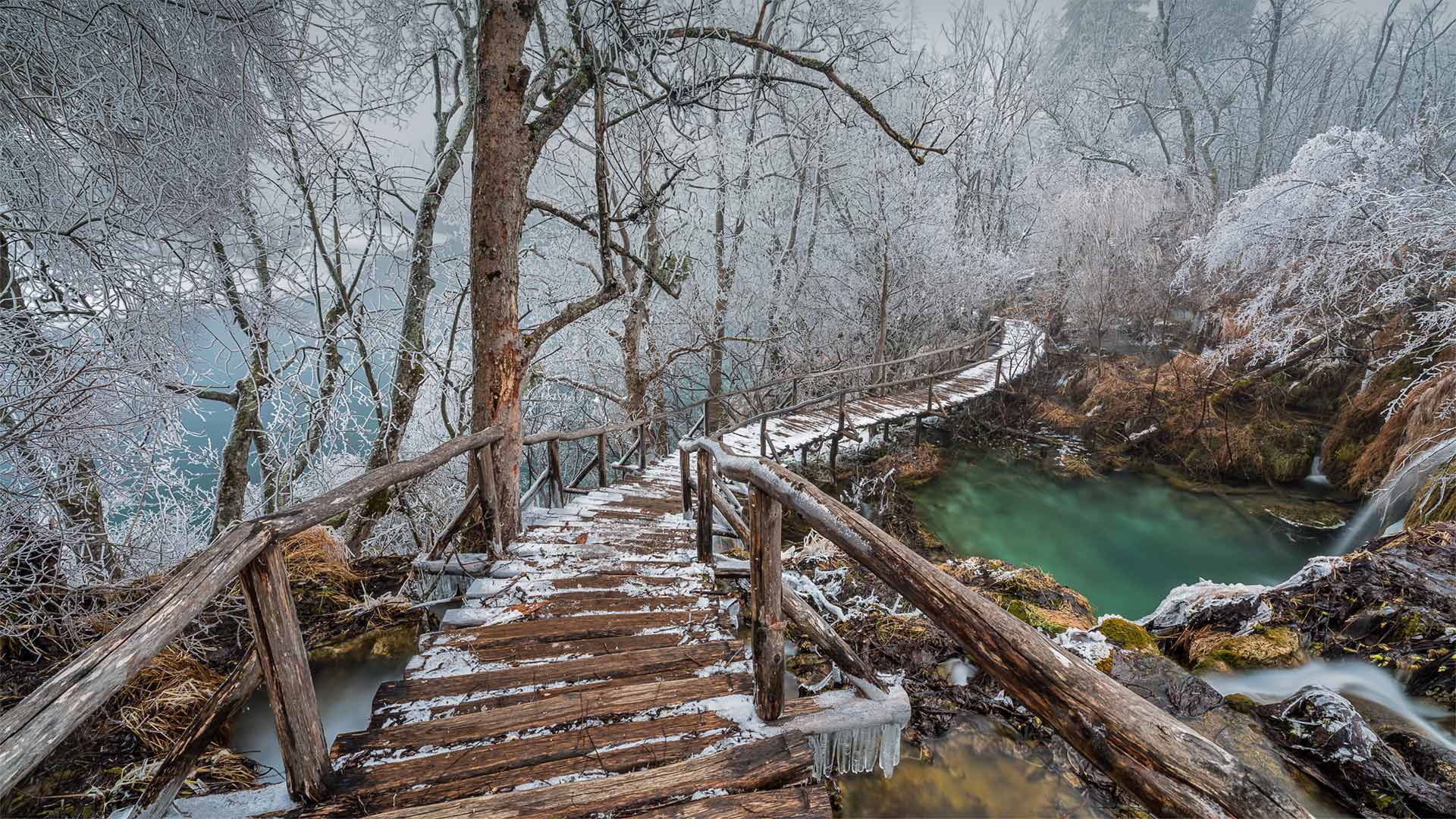
普利特维采湖群国家公园中的高架步道,克罗地亚 Elevated path in Plitvice Lakes National Park, Croatia (© Alessandro Laporta/Offset by Shutterstock)
普利特维采湖群国家公园中的高架步道,克罗地亚 Elevated path in Plitvice Lakes National Park, Croatia (© Alessandro Laporta/Offset by Shutterstock)
A hidden jewel in Croatia
Today we're walking out into the winter wonderland of Plitvice Lakes National Park, the oldest and largest national park in Croatia. More than a million tourists per year flock to this central mountainous region, renowned for its cascading waterfalls and 16 turquoise-colored lakes. These wooden pathways meander for miles around and above the lakes, beside waterfalls and over streams and rivers, which disappear into the moss-covered earth only to burst through again somewhere downstream. In fact, the lakes are all interconnected by underground flows and are separated from each other by natural dams of travertine.
The park is open year-round, and winter is its slowest season. If you're brave enough to venture down the park's slippery pathways in December or January, you may be rewarded with views straight out of a fairy tale.
克罗地亚的一颗隐藏的宝石
今天,我们要走进十六湖国家公园(Plitvice Lakes National Park)的冬季仙境,该公园是克罗地亚最古老,最大的国家公园。 每年有超过一百万的游客涌向这个中央山区,该山区以级联的瀑布和16个蓝绿色的湖泊而闻名。 这些木制小径在湖泊周围和上方蜿蜒数英里,在瀑布旁边,在溪流和河流上消失,消失在苔藓覆盖的泥土中,仅在下游某处再次突然出现。 实际上,所有湖泊都通过地下水流相互连接,并通过天然的堤坝隔开。
公园全年开放,冬季是最慢长的季节。 如果您有足够的勇气在12月或1月冒险走下公园的湿滑小径,您可能欣赏到的是童话故事般的风景。
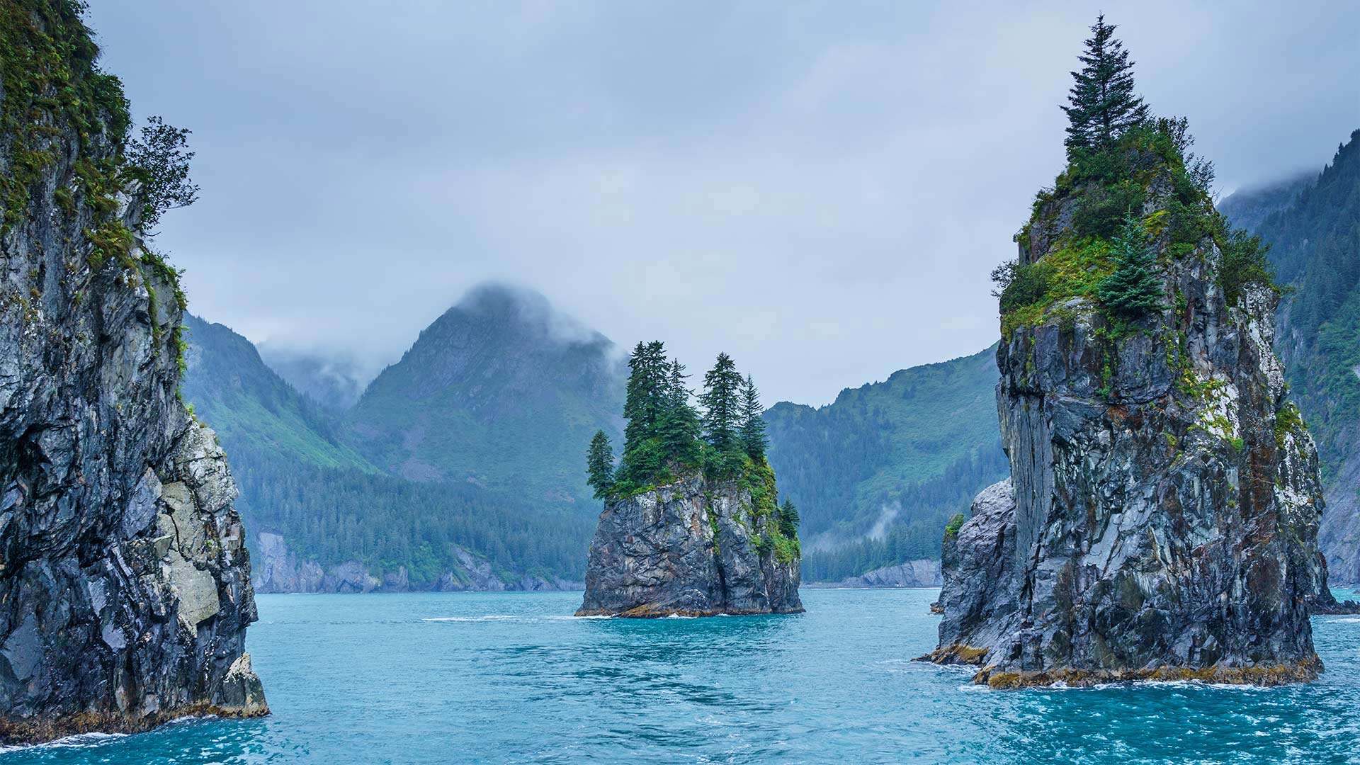
基奈峡湾国家公园的尖顶湾,阿拉斯加 Cove of Spires in Kenai Fjords National Park, Alaska (© Sekar B/Shutterstock)
基奈峡湾国家公园的尖顶湾,阿拉斯加 Cove of Spires in Kenai Fjords National Park, Alaska (© Sekar B/Shutterstock)
Protecting Alaska
On this day in 1980, President Jimmy Carter signed into law the Alaska National Interest Lands Conservation Act, which converted massive tracts of Alaskan wilderness into protected land. That single act 40 years ago doubled the size of the entire national park system. Alaska's eight national parks cover more than 54 million acres. The Cove of Spires, shown here, is just one of the dramatic glacial landscapes that you can experience in Kenai Fjords National Park. Located near Seward, Alaska, the park is home to 38 glaciers which cover over half the park's area in ice—though climate change has reduced that drastically over the last decades.