标签 国家公园 下的文章
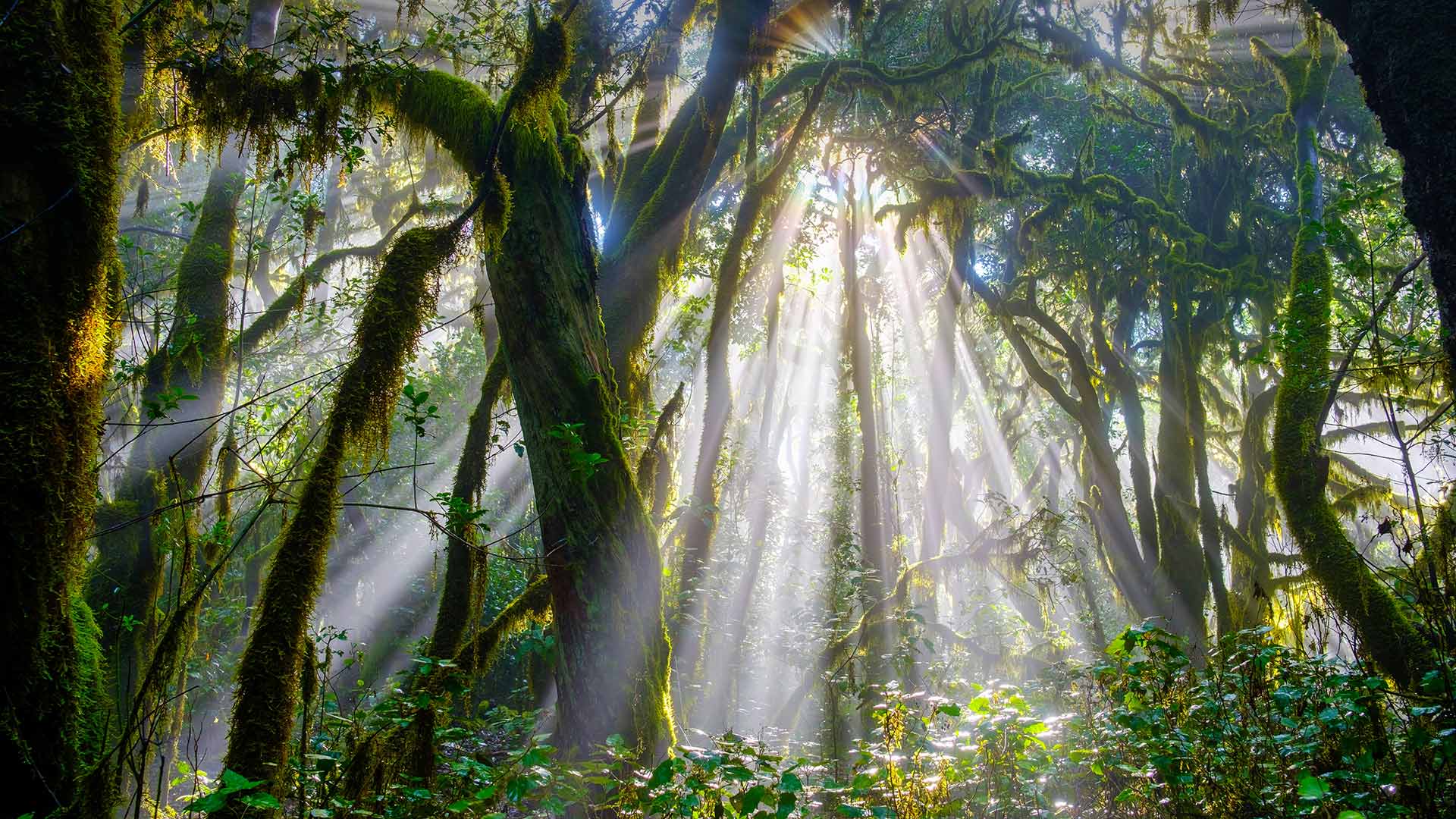
阳光穿透加拉霍奈国家公园中的森林,西班牙戈梅拉岛 Sunlight piercing a forest in Garajonay National Park, La Gomera, Spain (© Martin Siepmann/Westend61/Offset by Shutterstock)
阳光穿透加拉霍奈国家公园中的森林,西班牙戈梅拉岛 Sunlight piercing a forest in Garajonay National Park, La Gomera, Spain (© Martin Siepmann/Westend61/Offset by Shutterstock)
20 million years ago…
Let’s go back 20 million years ago. The forest that you see in our image today and that looks like a tropical jungle is one of the oldest in Europe. It is located in Garajonay National Park, on the Canary Island of La Gomera, Spain. And it represents the best example that exists in the Old World of the Cenozoic flora that once covered all the Mediterranean basin.
This is a laurissilva or laurel forest. And if it has survived to our days, it is because of the special conditions of temperature and humidity of this fascinating volcanic island, where the mist tangles around the trees covered by lichens and ferns, creating a dreamlike atmosphere that seems to be taken from a fairies tale. In fact, the name Garajonay comes from a popular legend that also names the highest peak in La Gomera, “Alto de Garajonay”, which is almost 1,500 meters high.
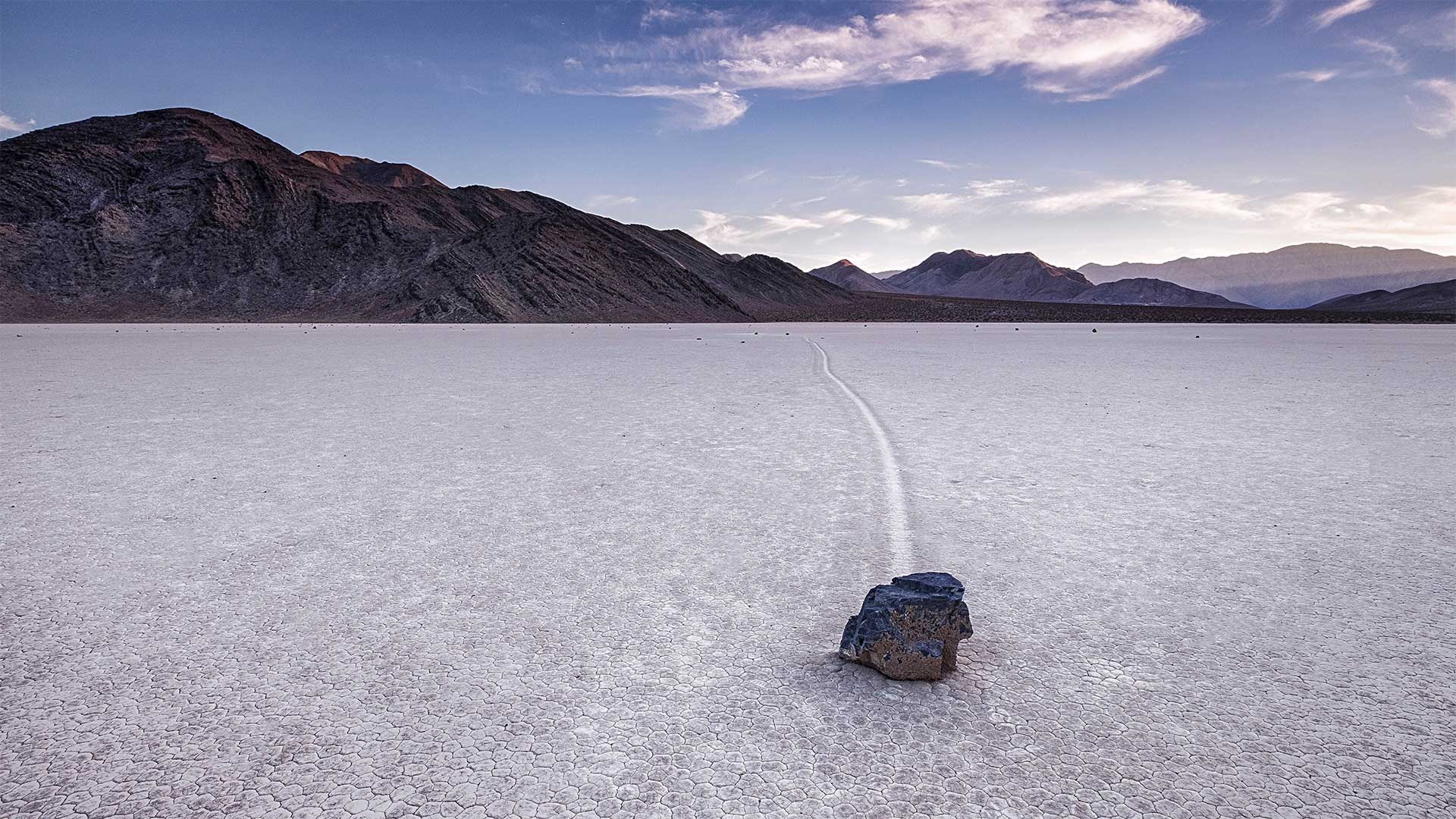
死亡谷国家公园跑道湖的迷踪石,加利福尼亚 Sailing stone at Racetrack Playa in Death Valley National Park, California (© Patrick Walsh/Getty Images)
死亡谷国家公园跑道湖的迷踪石,加利福尼亚 Sailing stone at Racetrack Playa in Death Valley National Park, California (© Patrick Walsh/Getty Images)
Rocks on the move
No, that stone in today's homepage image didn't get there by itself. Or, did it? Not only is Death Valley one of the hottest places on Earth, it also boasts a mysterious geologic phenomenon—rocks that drift across the exceptionally flat desert floor, seemingly under their own power. The rocks here at Death Valley's Racetrack Playa are known as 'sailing stones' and they can vary in size from a few ounces to hundreds of pounds. As seen in our image, the stones leave long trails behind them as they move across the scenic dry lakebed.
Since the stone trails were first observed in the early 1900s, no one knew just how the stones managed to have apparently 'sailed' across Racetrack Playa without someone to push them along. Because they'd never been seen moving, the sailing stones gave rise to many wild theories to explain their mobility. Then, in 2014, scientists captured the movement of the stones for the first time using time-lapse photography, and the mystery was finally solved: The stones move only with the perfect balance of melting ice, water, and wind. One day that winter of 2014, rain had formed a shallow pond that froze overnight. When it thawed in the next day's sun, the very thin ice sheet melted and cracked into floating panels. Driven by a light wind, these sheets accumulated behind the stones, and very slowly pushed them forward.
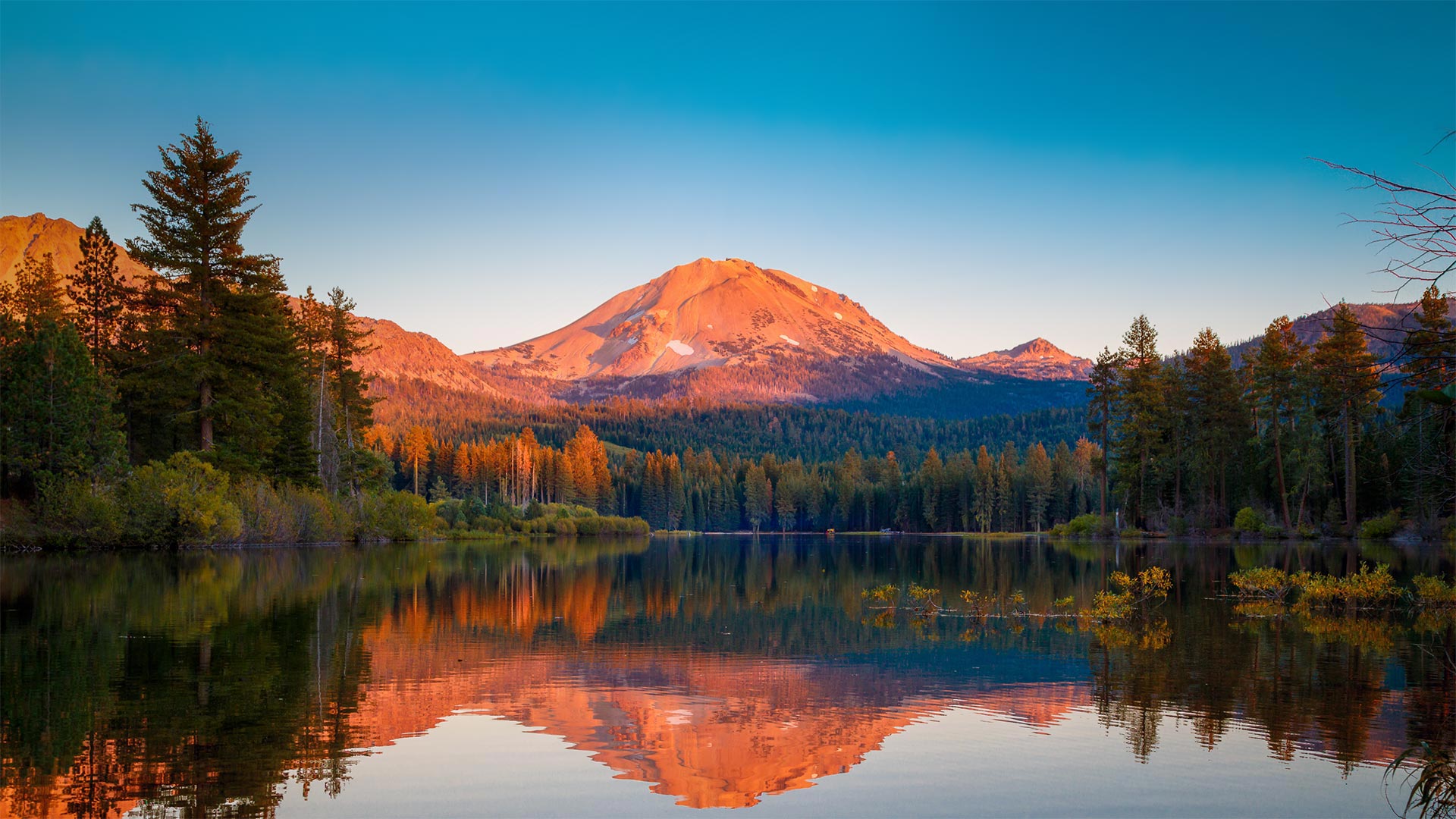
森火山国家公园中的拉森峰,加利福尼亚 Lassen Peak in Lassen Volcanic National Park, California (© Engel Ching/Shutterstock)
森火山国家公园中的拉森峰,加利福尼亚 Lassen Peak in Lassen Volcanic National Park, California (© Engel Ching/Shutterstock)
A peek at an explosive peak
We're looking at Lassen Peak, a volcano also known as Mount Lassen, and its reflection in Manzanita Lake. This stunning scene can be found in northern California's Lassen Volcanic National Park, which was established on this day in 1916. The volcano erupted between 1914 and 1917 (with some activity as late as 1921), but these days the surrounding area is a calm destination of trails, lakes, and stark lava beds. One of the least visited parks, Lassen was the first national park in California to fully reopen after being closed for COVID-19, although it implemented some restrictions to park services and facilities. The park also includes acres of mud pots, hot springs, steam vents, and fumaroles to remind you of the heat that's below you, including Boiling Springs Lake—one of the largest boiling lakes in the world at over 500 feet wide.
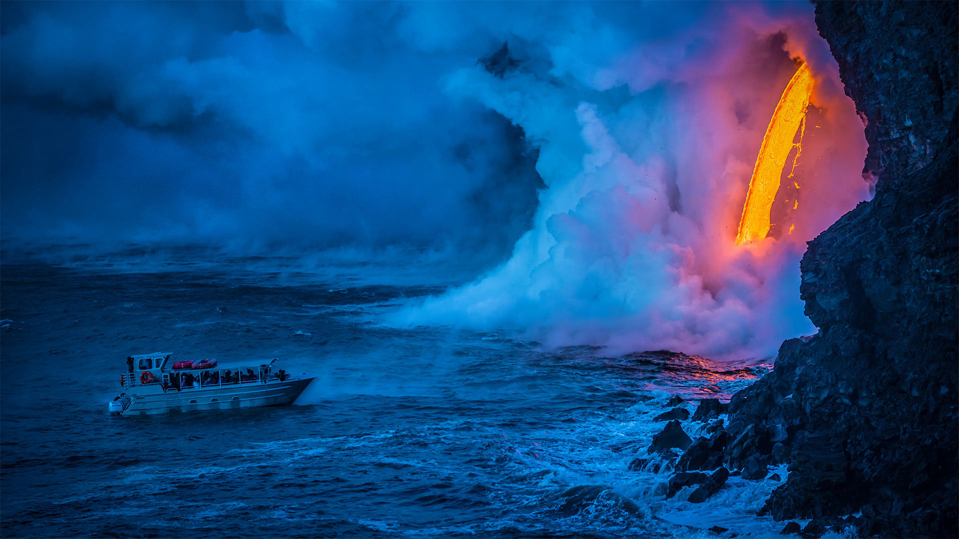
一艘游船经过时熔岩流撞击水面产生爆炸,夏威夷火山国家公园 A lava flow hits water to create an explosion as a tourist boat passes, Hawaii Volcanoes National Park (© Patrick Kelley/Getty Images)
一艘游船经过时熔岩流撞击水面产生爆炸,夏威夷火山国家公园 A lava flow hits water to create an explosion as a tourist boat passes, Hawaii Volcanoes National Park (© Patrick Kelley/Getty Images)
Where fire meets water
'Keep your distance' might be the mantra for 2020, but here at Hawaii Volcanoes National Park on the 50th state's 'Big Island,' it's always been good advice. Especially so for the passengers on this tour boat as they witness a red-hot lava flow hitting the chilly ocean with a tremendous explosion of steam.
We're visiting to mark the anniversary of the park's founding on August 1, 1916. Established some 34 years before Hawaii statehood, Hawaii Volcanoes was the first national park in a US territory. It's centered around two volcanic systems: Mauna Loa, one of the world's most massive volcanoes, and the highly active Kīlauea, which erupted continually from 1983 until an explosive 2018 eruption that calmed it for the time being.
塔霍湖国家公园中的沙港,内华达州 Sand Harbor, Lake Tahoe Nevada State Park, Nevada (© Mariusz Blach/Getty Images Plus)
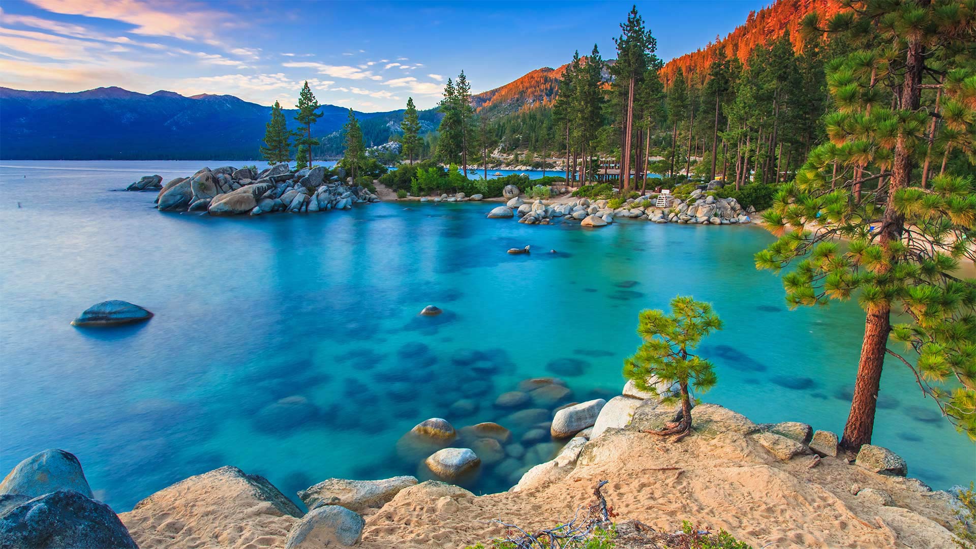
塔霍湖国家公园中的沙港,内华达州 Sand Harbor, Lake Tahoe Nevada State Park, Nevada (© Mariusz Blach/Getty Images Plus)
The Big Blue of the Sierras
High in the Sierra Nevada mountain range, straddling the border between Nevada and California, you'll find the largest alpine lake in North America, Lake Tahoe—sometimes called Big Blue. Seventy-two miles in circumference, with an average depth of 1,000 feet, it has the sixth-largest volume of any lake in the US—only the Great Lakes are larger. For at least 6,000 years, the territory of the Washoe people centered around Lake Tahoe, but the arrival of non-native people in the 19th century led to a series of armed conflicts and eventual loss of land to farms and townships.
The lake has a long history of disputes. Even its name wasn't formally agreed upon until 1945. Since the first European-American saw it in 1844, it has been called Lake Bonpland, Mountain Lake, Fremont's Lake, Fallen Leaf Lake, Maheon Lake, and Lake Bigler, after California's third governor and noted Confederate sympathizer, John Bigler. It was that name that Lake Tahoe finally supplanted on maps starting in 1862. But not everyone was enamored of the new moniker. Mark Twain famously criticized it as an 'unmusical cognomen' and that it should retain the name Bigler 'until some name less flat, insipid and spooney than Tahoe is invented for it.' Apparently, we're still waiting.
奥林匹克国家公园中的可可西里雨林,华盛顿州 The Hoh Rainforest in Olympic National Park, Washington state (© Jorge Romano/Offset by Shutterstock)
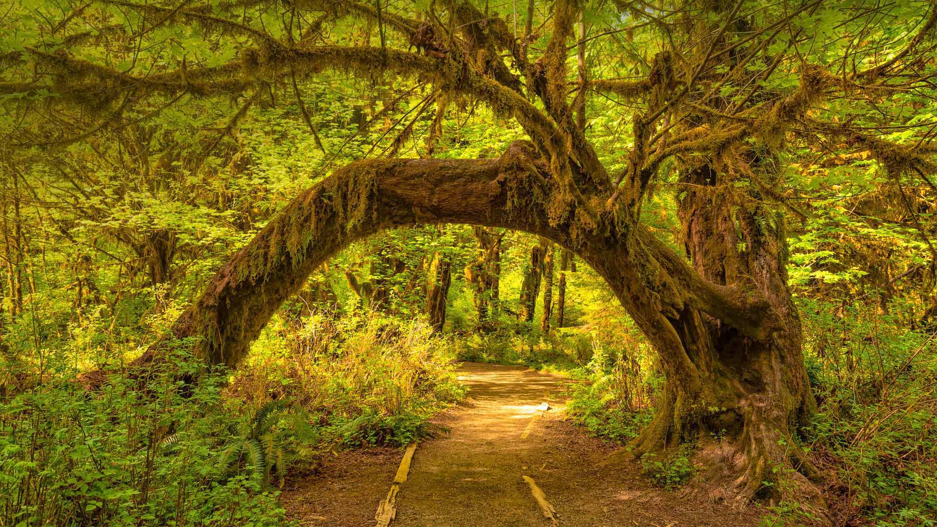
奥林匹克国家公园中的可可西里雨林,华盛顿州 The Hoh Rainforest in Olympic National Park, Washington state (© Jorge Romano/Offset by Shutterstock)
Welcome to the Hoh
Don't let this sunny picture fool you. The Hoh, a temperate rainforest on the western side of Olympic National Park in Washington state, sees between 12 and 14 feet of rain each year, making it one of the wettest places in the continental US. But all that moisture creates a lush, even mystical environment. The forest features a mix of conifers and deciduous trees draped heavily with moss, like the arching big leaf maple in our homepage image. A stroll through the forest will also reveal the massive Sitka spruce and western hemlock that may reach more than 300 feet up into the dense canopy. Below, the woods teem with ferns, lichen, and other vegetation. It's an enchanted forest right out of a fairy tale.
班夫国家公园中莫兰湖的延时视频,加拿大艾伯塔省 Time-lapse video of Moraine Lake in Banff National Park, Alberta, Canada (© Schroptschop/Getty Images)

班夫国家公园中莫兰湖的延时视频,加拿大艾伯塔省 Time-lapse video of Moraine Lake in Banff National Park, Alberta, Canada (© Schroptschop/Getty Images)
Canada's $20 view
For Canada Day, we're looking at Moraine Lake in Banff National Park. And if you're thinking that this amazing view is worth more than $20, you're right. But this priceless scene was once featured on Canada's $20 bill, hence the nickname. Canada Day, celebrated on July 1, commemorates the date in 1867 when Canada was recognized as a self-governing country under the British Empire It's not exactly Canadian Independence Day–it marks the passing of the Constitution Act of 1867, which was the first major step toward Canada's sovereignty.
Moraine Lake is just one of the many beautiful areas in Canada's oldest national park. Located in Alberta's Rocky Mountains, Banff covers more than 2,500 square miles–though we should say 6,641 square kilometres. After all, it's Canada Day.
银河下的圣埃伦娜峡谷,德克萨斯州大弯国家公园 Santa Elena Canyon under the Milky Way in Big Bend National Park, Texas (© Stanley Ford/Shutterstock)
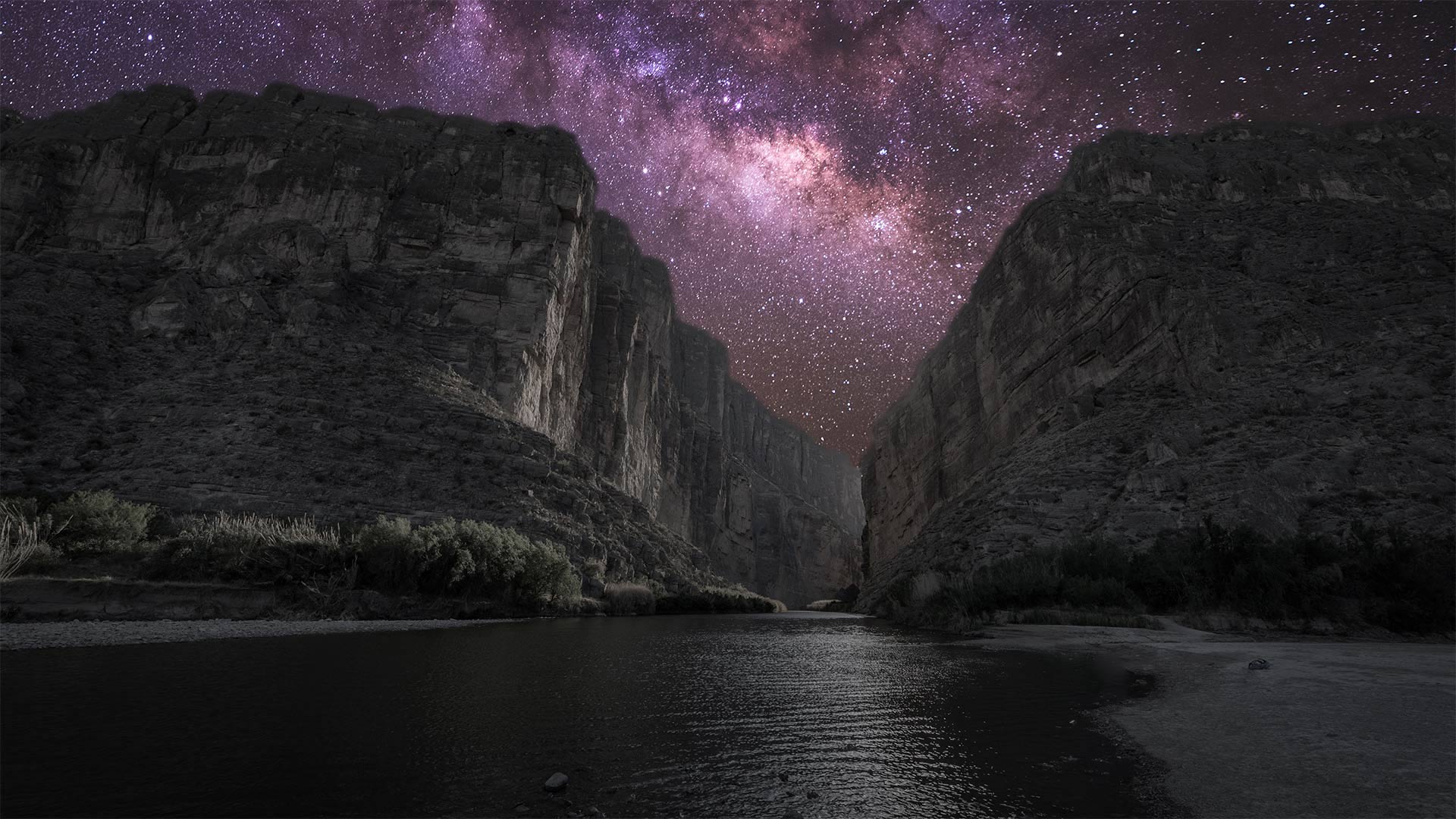
银河下的圣埃伦娜峡谷,德克萨斯州大弯国家公园 Santa Elena Canyon under the Milky Way in Big Bend National Park, Texas (© Stanley Ford/Shutterstock)
Big sky at Big Bend
Seventy-six years ago today, on June 12, 1944, Big Bend officially became a US national park. The park covers more than 800,000 acres in West Texas along the Mexico border. This vast area—big enough to swallow Rhode Island—contains mountain, river, and desert ecosystems, including the largest protected area of the Chihuahuan Desert in the United States. Far removed from any urban centers and the light pollution that comes with them, Big Bend boasts some of the darkest skies you'll find in the lower 48, earning it a designation as an International Dark Sky Park. Even after 76 years, Big Bend still glows.
锡安国家公园中的Walter's Wiggles小径,犹他州 Walter's Wiggles trail in Zion National Park, Utah (© Dennis Frates/Alamy)
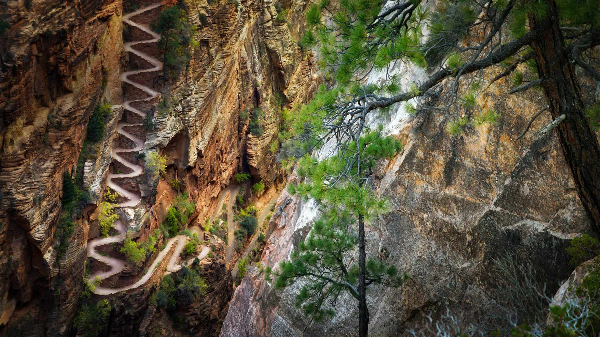
锡安国家公园中的Walter's Wiggles小径,犹他州 Walter's Wiggles trail in Zion National Park, Utah (© Dennis Frates/Alamy)
The long and wiggling path
In 1926, Walter Ruesch, the first superintendent of Zion National Park oversaw the construction of one of the park's most ambitious trails. It took 258 helicopter flights to haul in the concrete needed to construct the steep 21-switchback trail out of Refrigerator Canyon up to Angels Landing, but the view from the top makes it all worthwhile. Walter's Wiggles, one of the most difficult and dangerous trails in the park, was added to the National Registry of Historic Places in 1987.
But you don't need to haul tons of concrete or carve into the sheer sides of a remote canyon help carry on the tradition of trail-building. Today is National Trails Day, a day 'to come together in partnership to advocate for, maintain, and clean up public lands and trails.'
Usually this means heading out to a local wilderness area and joining others to clear or maintain some trails, but this year (as you may have noticed) is a little different. The American Hiking Society has organized a digital campaign to inspire individuals to unite for the protection of trails and access to public lands—without endangering one another.
同步发光萤火虫照亮了大烟山国家公园中的森林 Synchronous fireflies illuminate the forests of Great Smoky Mountains National Park, Tennessee (© Floris van Breugel/Minden Pictures)
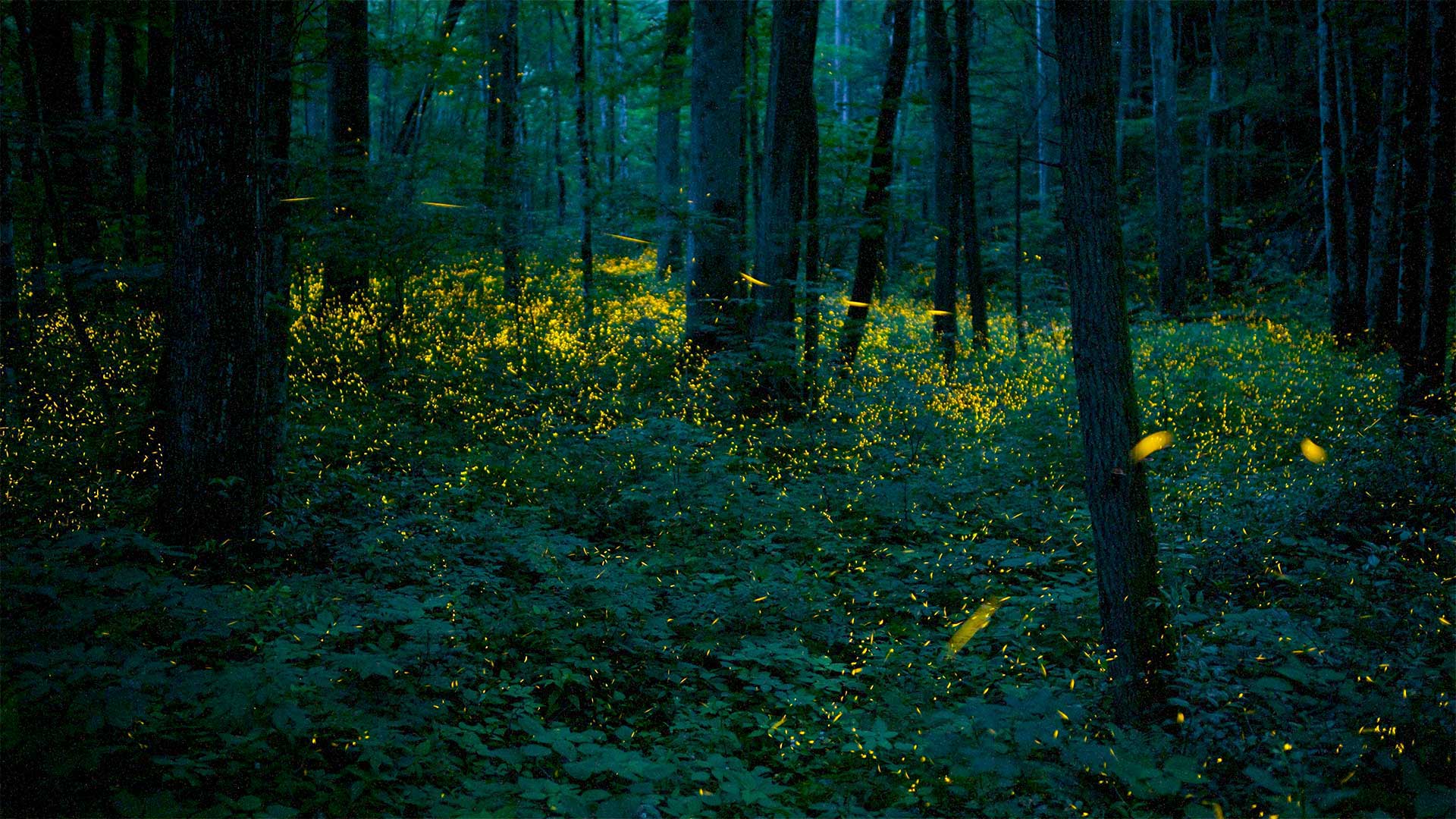
同步发光萤火虫照亮了大烟山国家公园中的森林 Synchronous fireflies illuminate the forests of Great Smoky Mountains National Park, Tennessee (© Floris van Breugel/Minden Pictures)
By the light of the fireflies
Every year between late May and mid-June, synchronous fireflies gather into a sparkling, rhythmic lightshow in the forests of Great Smoky Mountains National Park. As part of their 2-week mating display, the female lighting bugs synchronize their flashes with nearby males so that every few seconds waves of light ripple through the woods. While Photinus carolinus is only one of at least 19 species of fireflies that live in Great Smoky Mountains National Park, synchronous fireflies can be found in a few other places on Earth as well, particularly in Southeast Asia.
Each species of firefly has a characteristic flash pattern that helps the males and females recognize each other. In most species, like this one, the males fly and flash, while the females generally stay still and respond with a flash of their own. It's not clear why some species of fireflies flash synchronously, although some hypotheses involve diet, social interaction, and altitude. No matter why they do it, the flashing of lightning bugs is a magical sight to see—and we can all use a little magic sometimes.