标签 国家公园 下的文章
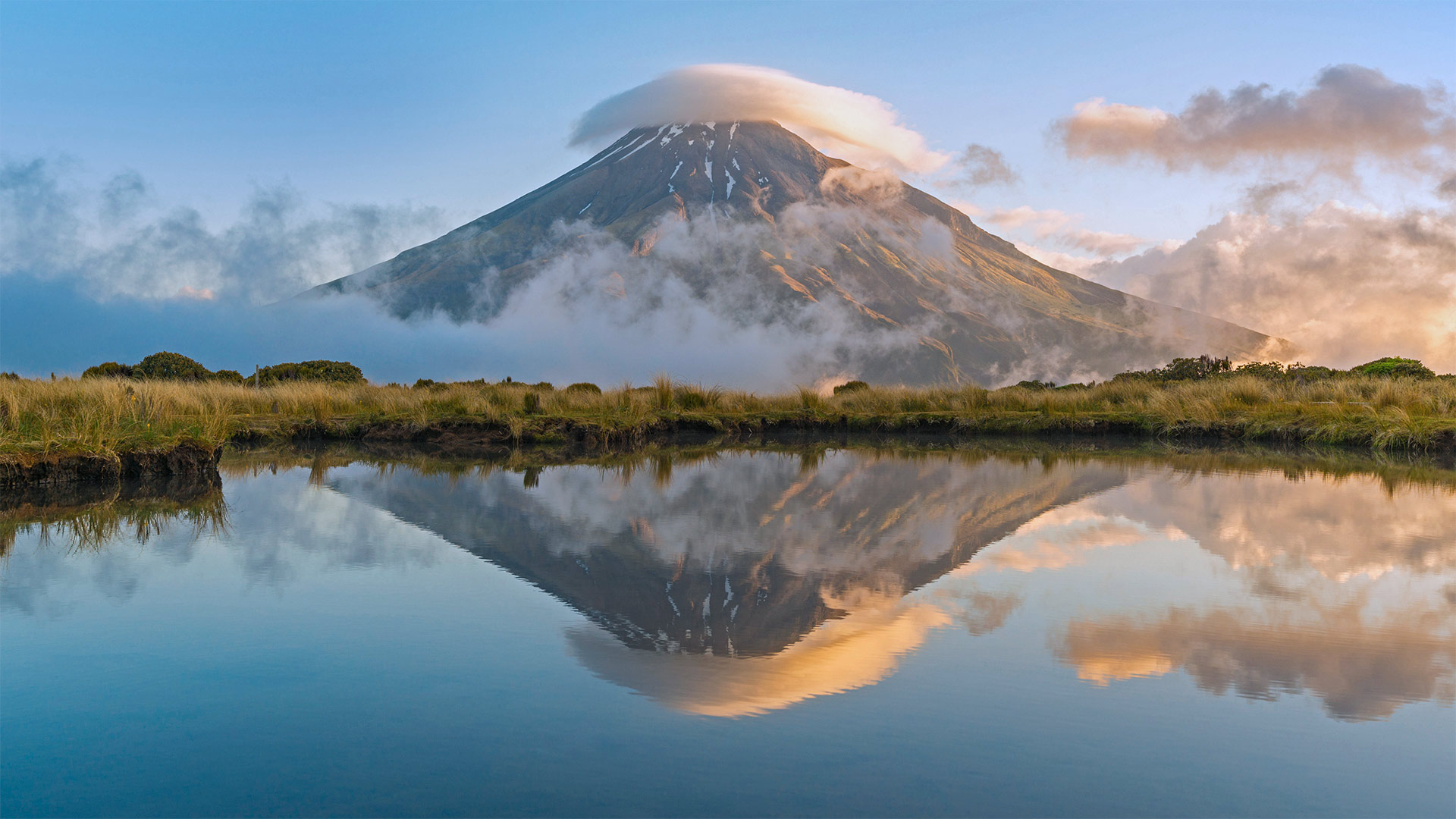
塔拉纳基山,新西兰艾格蒙特国家公园 Mount Taranaki, Egmont National Park, North Island, New Zealand (© Francesco Vaninetti/plainpicture)
塔拉纳基山,新西兰艾格蒙特国家公园 Mount Taranaki, Egmont National Park, North Island, New Zealand (© Francesco Vaninetti/plainpicture)
New Zealand's loneliest mountain
According to the legends of New Zealand's aboriginal Māori people, the lonely Mount Taranaki wasn't always lonely. Taranaki, the story goes, once lived among other mountains in the North Island's center. But Taranaki feuded with the powerful volcano Tongariro over the love of the pretty peak Pīhanga. In their epic battle, the now flat-topped Tongariro lost his head but emerged victorious. The vanquished Taranaki wandered west, cutting trenches as he trudged to the shore and filling them with lovesick tears to create the region's rivers.
Now that Taranaki's settled in, the still-active stratovolcano's slopes and foothills comprise one of New Zealand's oldest national parks. Whether or not he's gotten over Pīhanga after untold millennia, Taranaki continues to compete with Tongariro even through modern myth: Taranaki had a star turn as Mount Fuji in background shots for 'The Last Samurai,' while the Tongariro area stood in for the cursed realm of Mordor in the 'Lord of the Rings' films.
卡尔巴里国家公园,澳大利亚 Kalbarri National Park, Australia (© AWL Images/Offset by Shutterstock)
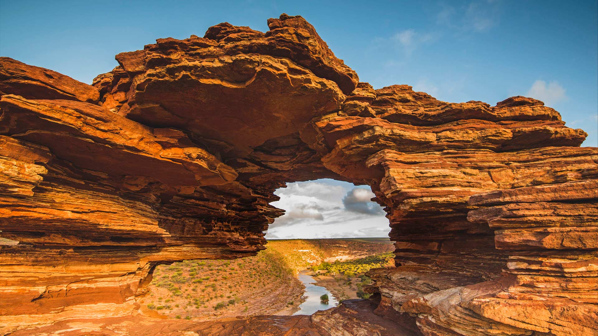
卡尔巴里国家公园,澳大利亚 Kalbarri National Park, Australia (© AWL Images/Offset by Shutterstock)
What a wonderful window
From planes to cafes, many of us love a nice ‘window view’, but we’d argue that few provide sights as truly spectacular as Nature’s Window here in Kalbarri National Park. Located 485 km north of Perth, the park covers around 186,000 hectares, and traditionally sees thousands of visitors each year to enjoy its rocky terrain and quiet peacefulness.
The main attraction, however, is this sandstone stunner – formed after many years of wind erosion. Find the perfect angle you’ll be able to catch incredible glimpses of the river in the distance and its surrounding greenery. It’s also one of the best places in the country to watch the sunrise. If you prefer a little more adventure, you can take a stroll to the Kalbarri Skywalk that shows off views of the gorge, or enjoy a spot of abseiling, rafting, and canoeing.
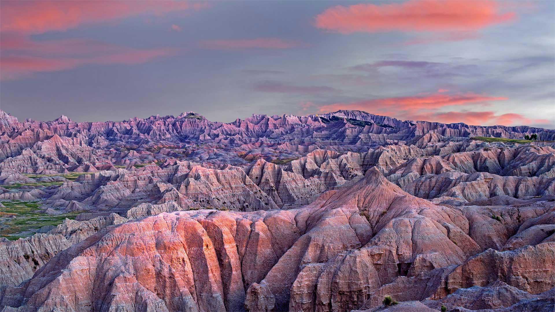
恶地国家公园,南达科他州 Badlands National Park, South Dakota (© Dennis Frates/Alamy)
恶地国家公园,南达科他州 Badlands National Park, South Dakota (© Dennis Frates/Alamy)
Baddest of the badlands
Heading west on Interstate 90, peek out the driver's side as you approach Rapid City, South Dakota, for the first clue you've entered the Wild West: the expansive, layered landscape of Badlands National Park. It's enjoyed government protection since 1939, first as a national monument and more completely after it was upgraded to national park status on this day in 1978. The park protects 244,000 acres of dramatically eroded bedrock replete with fossil beds—as well as the nation's largest mixed-grass prairie, hosting bison, prairie dogs, and endangered black-footed ferrets.
Before it was a national park, Native Americans called the Badlands home for more than 10,000 years. The Lakota had displaced other tribes to control the region by about 150 years ago—the same time settlers from the East were undermining Native power structures throughout the frontier. In response to these incursions, many Lakota in the late 19th century embraced a cross-tribal spiritual movement known as the 'Ghost Dance.' It was a system of rituals—including the namesake circle dance often performed here in the Badlands—believed to impede the encroachment of white settlers and deliver Natives from violence. But those efforts seemed futile by late 1890 as, just south of here, conflicts culminated in the Wounded Knee massacre where US forces killed more than 250 unarmed Lakota men, women, and children.
The conflict and ensuing tragedy is one of American history's ugliest chapters—but it bears reflection during Native American History Month as we ponder the Badlands' past, as vast and multilayered as the bedrock that makes it up.
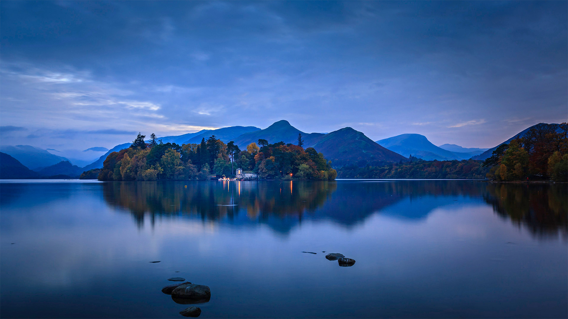
德文特湖上的德文特岛房屋,英国坎布里亚郡湖区国家公园 Derwent Island on Derwentwater in the Lake District National Park, Cumbria, England (© Chris Warren/eStock Photo)
德文特湖上的德文特岛房屋,英国坎布里亚郡湖区国家公园 Derwent Island on Derwentwater in the Lake District National Park, Cumbria, England (© Chris Warren/eStock Photo)
Languid life on the Lakes
Surrounded not only by the spectacular fells (moors) and pikes (peaks) seen here on the horizon but also lush, rolling farmlands, the lake known as Derwentwater is one of more than 30 bodies of water in North West England's Lake District. Rounder and broader in shape than its fingerlike brethren, Derwentwater is home to several small isles like this one—though the classical estate built here is an unusual interruption of this mostly-natural tableau.
We're seeing the island's boathouse, one of several buildings that a wealthy eccentric named Joseph Pocklington had erected shortly after his 1778 purchase of the island. The main building, Derwent Island House, is set out of view farther back on the woody isle. The estate once included a stone fort housing a cannon, often fired to incite playful 'raids' on the island during regattas Pocklington hosted each year on the lake. Critics of old—among them poet William Wordsworth, who famously loved the Lakes—decried Pocklington's additions as eyesores, but modern-day visitors gladly line up to visit the Italianate estate on the five days a year that it's open to the public.
大提顿国家公园中的野牛,怀俄明州 Bison in Grand Teton National Park, Wyoming (© Brian Evans/Getty Images)
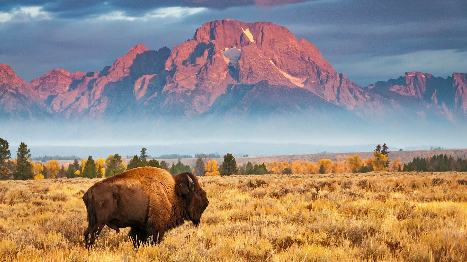
大提顿国家公园中的野牛,怀俄明州 Bison in Grand Teton National Park, Wyoming (© Brian Evans/Getty Images)
National Bison Day
If ever there was an animal that deserved some recognition, it's the bison. Since 2012, National Bison Day has been observed on the first Saturday of November to acknowledge the animal's cultural, historical, and economic significance—as well as its remarkable comeback. Bison were once plentiful in North America. Tens of millions strong in the 1800s, they roamed in great herds, helping to diversify and maintain the prairie habitat. They've also played several important roles in Native American cultures. Indigenous peoples have used every part of the bison for food, utensils, and clothing—and they pay tribute to the giant beasts in religious rituals.
Settlement of the American West caused habitat loss for the bison and that, combined with overhunting, nearly wiped out the species altogether—until ranchers, conservationists, and politicians teamed up to save them. In 1913, 14 bison from the Bronx Zoo were shipped to a wildlife refuge to revive the population. Fast forward to today, and more than 20,000 bison roam on public lands in the United States.
Lauwersmeer国家公园上空的椋鸟群,荷兰 Starlings flock over Lauwersmeer National Park, Netherlands (© Frans Lemmens/Alamy)
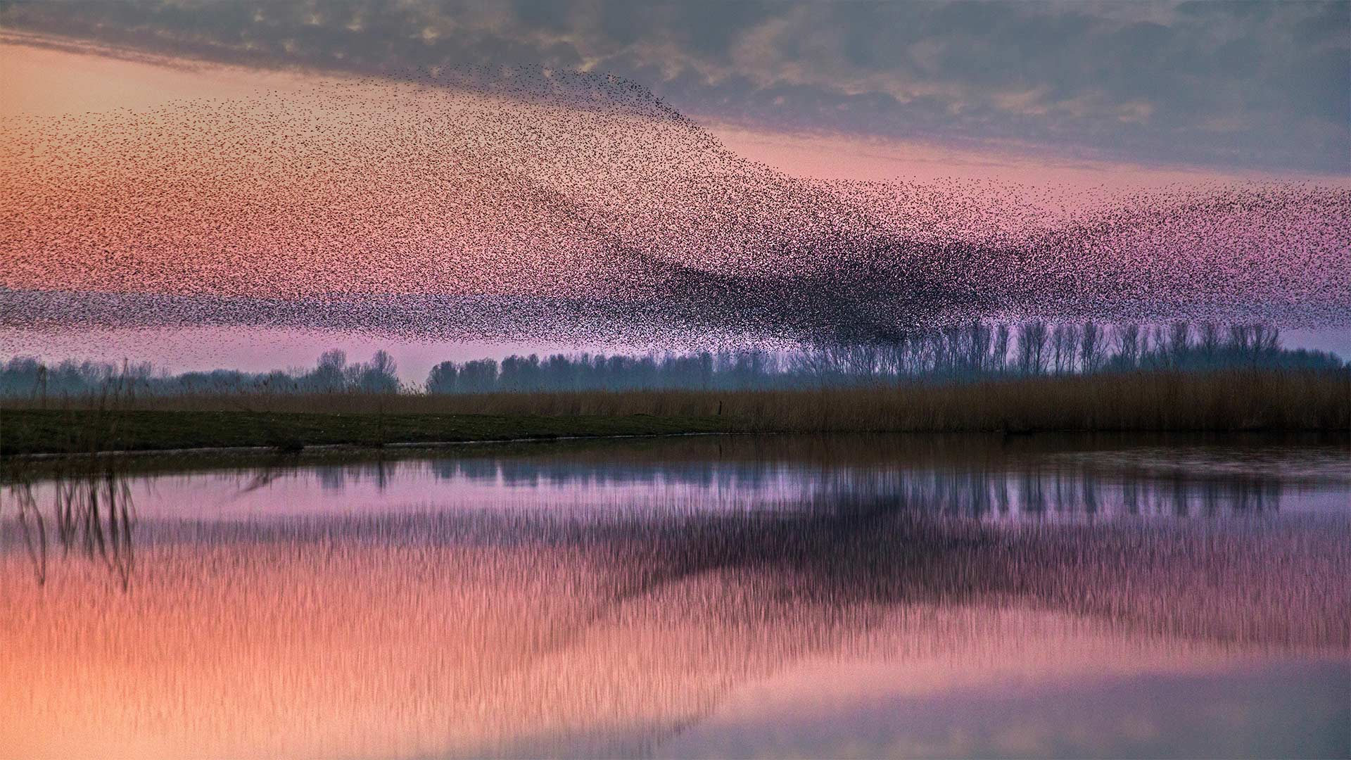
Lauwersmeer国家公园上空的椋鸟群,荷兰 Starlings flock over Lauwersmeer National Park, Netherlands (© Frans Lemmens/Alamy)
Moving as one
After the nesting and breeding seasons of spring and summer have passed, starlings become highly social birds, often gathering in flocks that number in the thousands. These flocks sometimes take the form of a murmuration—when the birds form a group large and dense enough that they appear to move together as a single organism, even if the movements seem arbitrary. Though scientists still don't quite understand how the individual starlings in a murmuration coordinate their tight, fluid formations, the behavior is thought to be a way to confuse predators.
Imagine if you're a falcon on the hunt and you see a small group of starlings—an easy meal if you catch one. But if the starlings spot the predator first, they may form a murmuration, swooping and diving as one, making it difficult for the falcon to isolate and hunt an individual starling.
俯瞰正在飞越洛斯罗克斯群岛国家公园的美洲红鹳,委内瑞拉 Aerial view of American flamingos flying over Los Roques Archipelago National Park, Venezuela (© Cristian Lourenco/Getty Images)
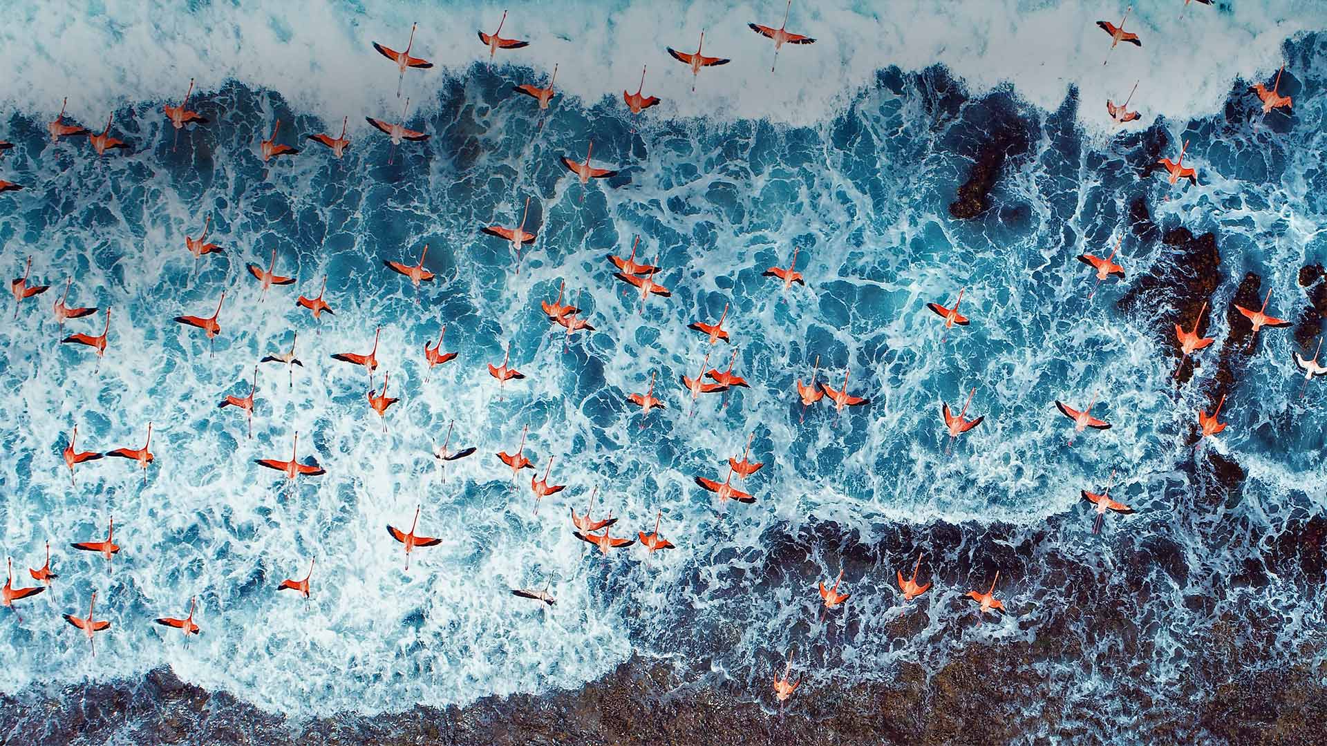
俯瞰正在飞越洛斯罗克斯群岛国家公园的美洲红鹳,委内瑞拉 Aerial view of American flamingos flying over Los Roques Archipelago National Park, Venezuela (© Cristian Lourenco/Getty Images)
Birds of a feather
Today is World Migratory Bird Day in Latin and South America, so to honor the occasion we've chosen these flamingos, rising above the Caribbean Sea off the coast of Venezuela. Changes in daylight hours and food availability can trigger seasonal migrations in many bird species, including flamingos. American flamingos like these will migrate relatively short distances, usually to ensure a steady food supply. Found mainly throughout the Caribbean, their range extends as far north as southern Florida.
The nonprofit sponsor of World Migratory Bird Day, Environment for the Americas, focuses its efforts on conserving habitats for the hundreds of bird species that migrate along north-south routes in the Americas, from Alaska and Canada to Argentina and Chile and places in between. Most of these migratory birds use established flight paths called flyways to travel between their breeding grounds and overwintering areas. These aerial highways tend to avoid obstacles such as mountain ranges and oceans, running parallel to topographical barriers and following routes along coasts or major river valleys. Birds migrating through North America follow four main flyways, the Atlantic, Mississippi, Central, and Pacific. Because the birds need adequate food and shelter at stopover points along the way, conservation of habitats through these corridors is especially important to the birds' survival. This year, with wildfires raging across the American West, the Pacific flyway has been especially peril
While October 10 is World Migratory Bird Day in Mexico, Central, and South America, bird lovers in the US and Canada observe this conservation event on the second day in May. But wherever you live, every day is a good day to pick up some binoculars and watch the birdlife outside your own window.
大雾山国家公园中的咆哮叉,田纳西州 Roaring Fork in Great Smoky Mountains National Park, Tennessee (© Bernie Kasper/Getty Images)
大雾山国家公园中的咆哮叉,田纳西州 Roaring Fork in Great Smoky Mountains National Park, Tennessee (© Bernie Kasper/Getty Images)
Falling for Tennessee
Although it might not look like it in this image of a tranquil fall day, Roaring Fork in the Great Smoky Mountains National Park has earned its ferocious name. The stream descends 2,500 feet over just 2 miles—a steep drop. After heavy rains, Roaring Fork transforms into a whitewater rush, the sound echoing off the mountainsides. But during drier spells, the stream quiets to more of a babbling brook, as seen here along the Roaring Fork Motor Nature Trail. The 5.5-mile popular loop drive passes waterfalls, well-preserved historic log cabins, and scenic overlooks of a forest that during this time of year reaches its fall color peak, exploding in bold yellows, oranges, and reds. These are just some of the things that make Great Smoky Mountains the most popular national park in the country.
以桑格雷-德克里斯托山为背景的沙丘,科罗拉多州大沙丘国家公园 Sand dunes with Sangre de Cristo Mountains in the background, Great Sand Dunes National Park and Preserve, Colorado (© Tim Fitzharris/Minden Pictures)
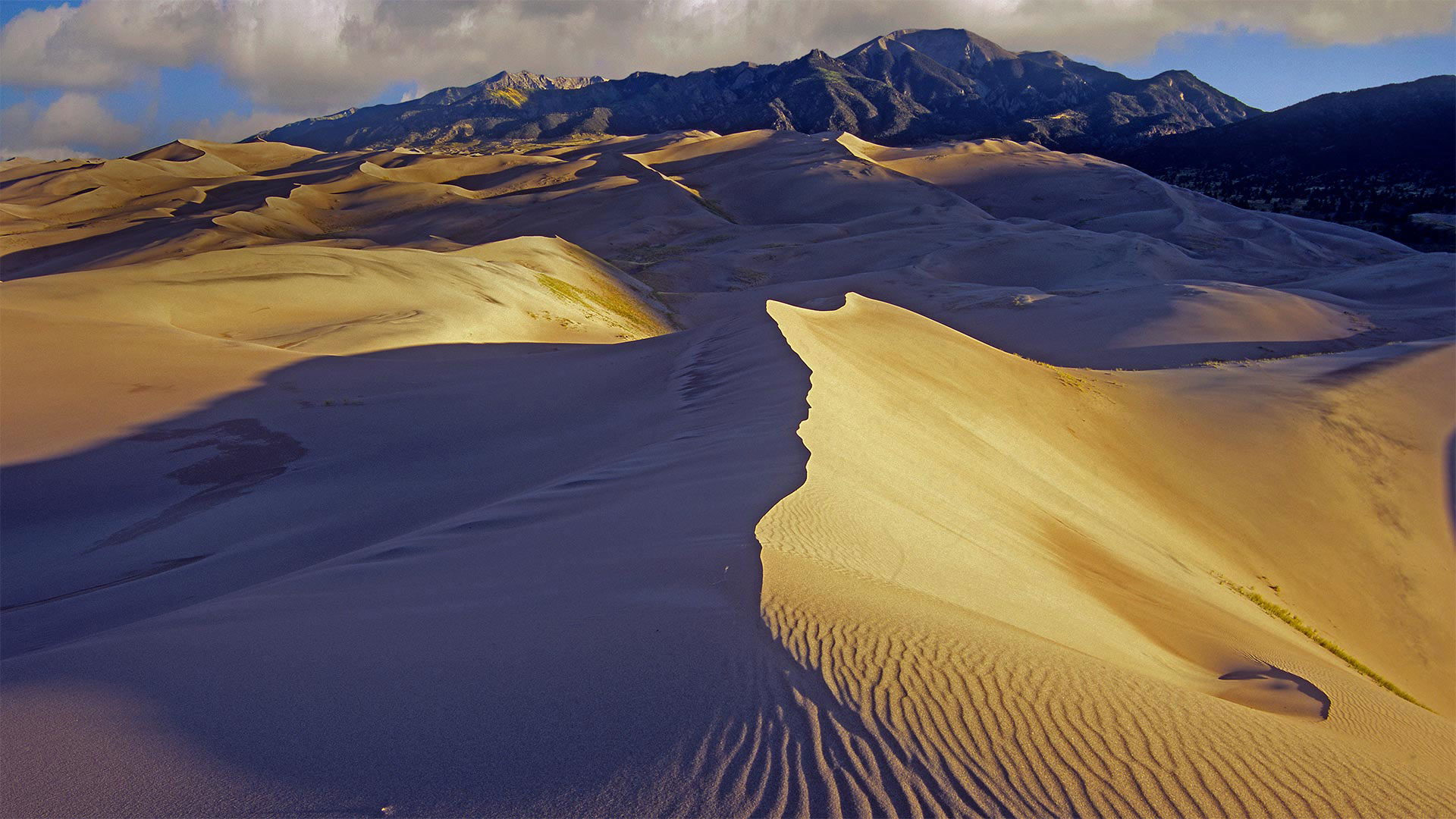
以桑格雷-德克里斯托山为背景的沙丘,科罗拉多州大沙丘国家公园 Sand dunes with Sangre de Cristo Mountains in the background, Great Sand Dunes National Park and Preserve, Colorado (© Tim Fitzharris/Minden Pictures)
Super Sandy Sweet 16
We're in the Rockies of southern Colorado to celebrate Great Sand Dunes National Park and Preserve's 16th year as a full-fledged national park—though it was a national monument from 1932, and both the dunes themselves and the surrounding valley's history are far more ancient.
The dunes lie at the edge of the fertile, expansive San Luis Valley just east of the Rio Grande's headwaters and west of the Sangre de Cristo range shown here behind the dunes. Humans have lived around here for at least 11,000 years. But that's just a few grains in the hourglass for this sand field that formed when huge glacial lakes dried up, leaving sediments that were blown by wind against the mountains to slowly form the tallest sand dunes in North America.
Khuean Srinagarindra国家公园的Huay Mae Khamin瀑布,泰国 Huay Mae Khamin waterfall in Khuean Srinagarindra National Park, Thailand (© ImpaKPro/Getty Images)
Khuean Srinagarindra国家公园的Huay Mae Khamin瀑布,泰国 Huay Mae Khamin waterfall in Khuean Srinagarindra National Park, Thailand (© ImpaKPro/Getty Images)
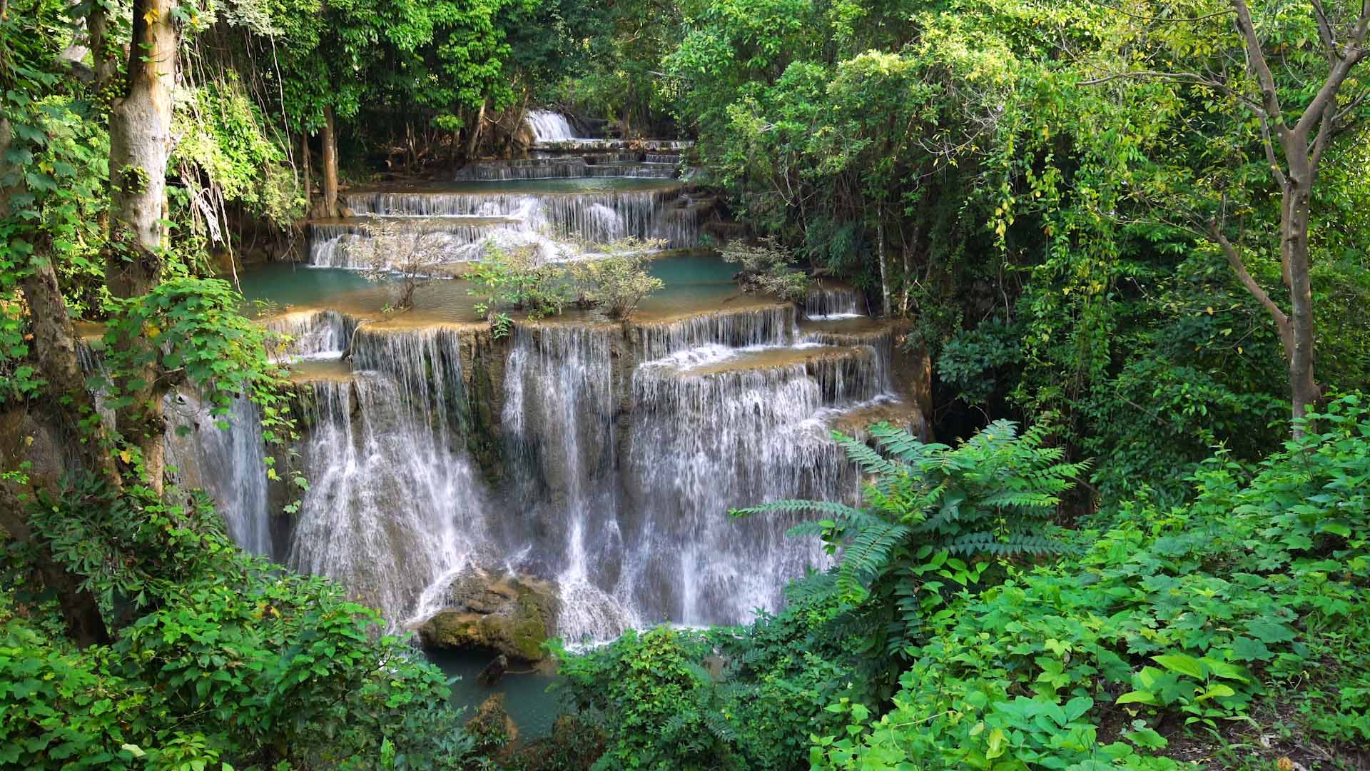
Hidden beauty in Thailand
One of Thailand's best-kept secrets, Huay Mae Khamin waterfall can be found in the forests of Khuean Srinagarindra National Park. One of the country's lesser-known waterfalls, it's especially picturesque this time of year when the changing leaves provide a backdrop for the bright green water. Getting its water from the mountains to the east of the national park, the waterfall stretches just over a mile long, the water travels over seven different levels before joining the Khwae Yai River below. The falls generally have water all year round, but in 2017, during the dry season, the river feeding the falls dried out completely for the first time, and the park was closed to visitors until the rainy season. Though the journey to this peaceful retreat might be long, it's found a place on our ever-growing list of future travel destinations.