标签 国家公园 下的文章
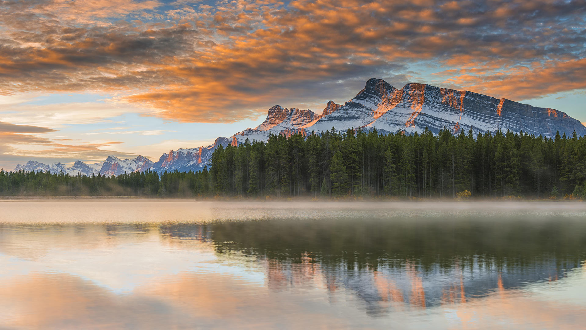
双杰克湖,班夫国家公园,艾伯塔省,加拿大 (© SnapRapid/Offset)
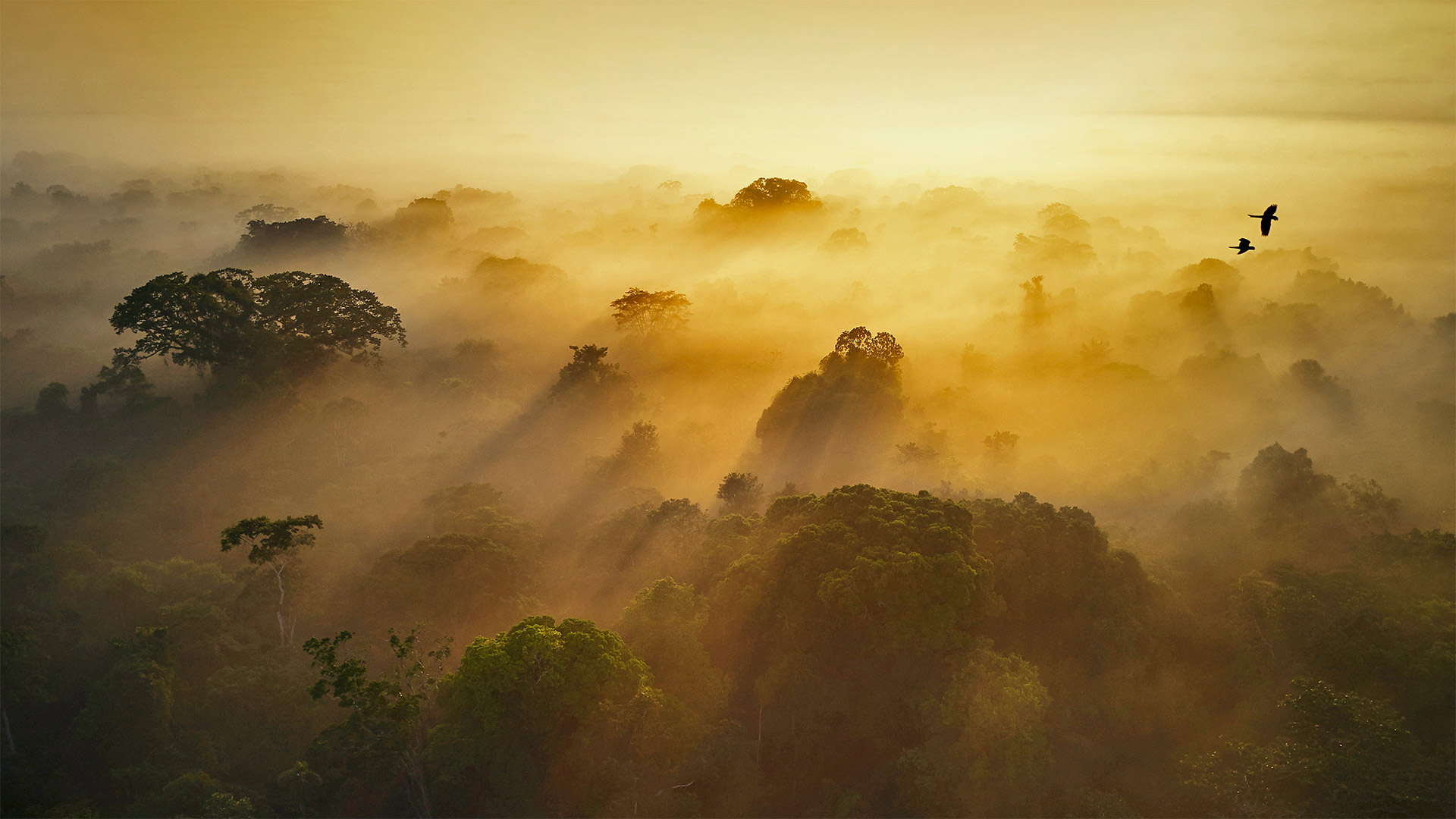
亚苏尼国家公园,厄瓜多尔 Yasuní National Park in Amazonian Ecuador (© Paul Bertner/Minden Pictures)
亚苏尼国家公园,厄瓜多尔 Yasuní National Park in Amazonian Ecuador (© Paul Bertner/Minden Pictures)
地球之肺 The lungs of Earth
World Rainforest Day
Perhaps no other place on Earth plays a more crucial role in sustaining life as we know it than the Amazon rainforest, the largest in the world. The Amazon spans nine countries in South America including Ecuador, where this pristine ecoregion is protected by the Yasuní National Park, shown here. Today is set aside as World Rainforest Day, to remember the vital role of this and other rainforests and to champion efforts to protect them. The world's rainforests are under threat like never before from deforestation driven by agriculture and cattle ranching. Some studies have indicated humans have degraded or destroyed more than half of the world's rainforests. Fewer trees mean warmer temperatures, which increases the risk of drought and wildfire and compounds the damage of deforestation.
The Amazon has been called the lungs of the planet because the estimated 390 billion trees here convert much of the oxygen humans and other animals need to survive. The Amazon also cools our planet by capturing and storing carbon. It is as much the planet's air conditioner as it is its lungs. For that reason, the health of rainforests is crucial to arresting climate change.
The other gift of rainforests, and of the Amazon in particular, is biodiversity. The number of species of plants, animals, and insects in the Amazon is not in the thousands, but in the millions. Scientists estimate half of the planet's biodiversity exists in the Amazon. In fact, many of our modern pharmaceuticals are derived from Amazon plants. That makes the Amazon not just the Earth's lungs and air conditioning, but also its medicine cabinet.
世界雨林日
也许地球上没有其他地方比世界上最大的亚马逊雨林在维持生命方面发挥着更重要的作用。亚马逊河横跨包括厄瓜多尔在内的南美洲九个国家,这里的亚苏尼国家公园保护着这个原始的生态区。今天被定为世界雨林日,以纪念这片和其他雨林的重要作用,并支持保护它们的努力。由于农业和畜牧业造成的森林砍伐,世界雨林受到前所未有的威胁。一些研究表明,人类已经退化或破坏了世界上一半以上的雨林。树木减少意味着气温升高,这增加了干旱和野火的风险,并加剧了毁林的破坏。
亚马逊河被称为地球的肺,因为这里估计有3900亿棵树转化了人类和其他动物生存所需的大部分氧气。亚马逊还通过捕获和储存碳来冷却我们的地球。它既是地球的空调,也是地球的肺。因此,雨林的健康对于遏制气候变化至关重要。
热带雨林,尤其是亚马逊的另一个礼物是生物多样性。亚马逊河流域的植物、动物和昆虫种类不是数千种,而是数百万种。科学家估计,地球上一半的生物多样性存在于亚马逊地区。事实上,我们的许多现代药物都来自亚马逊植物。这使得亚马逊不仅是地球的肺和空调,而且还是它的药柜。
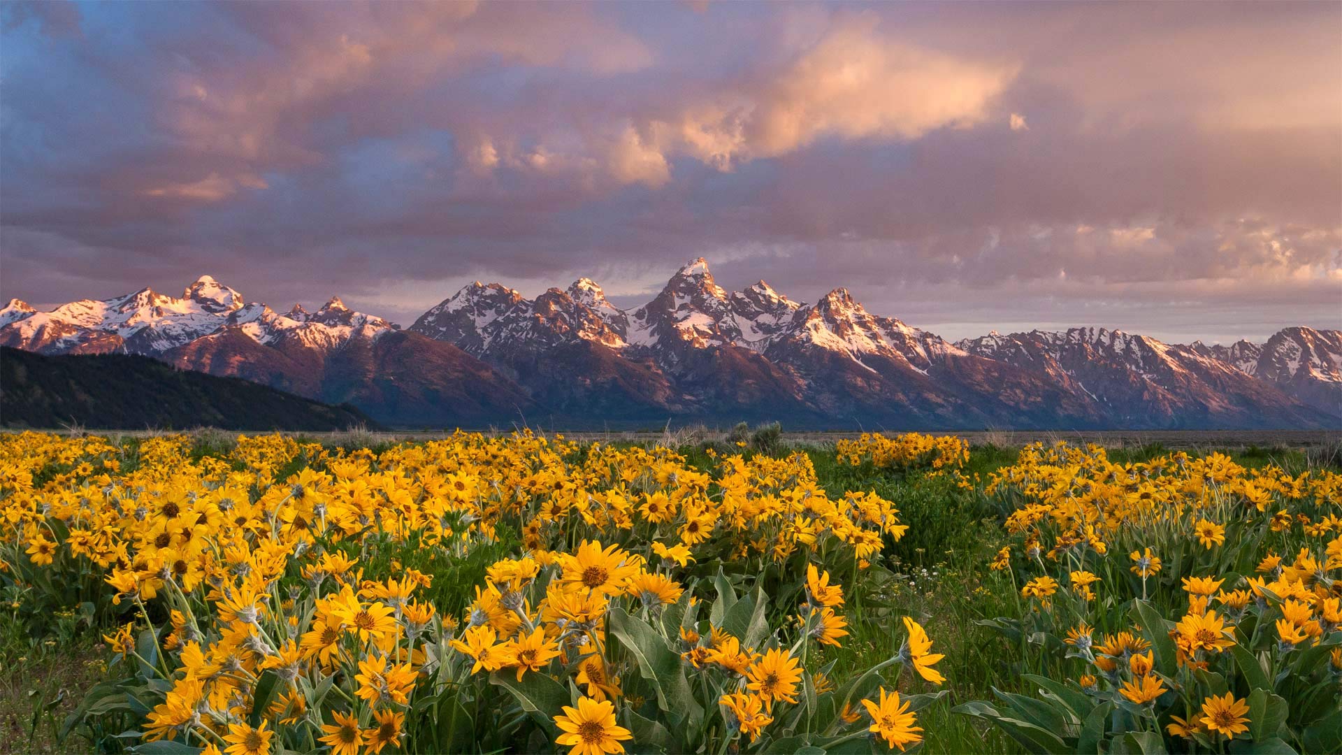
山下盛开的箭叶脂根菊,美国大提顿国家公园 Balsamroot wildflowers bloom below the Teton Mountains in Grand Teton National Park, Wyoming (© Mike Cavaroc/Tandem Stills + Motion)
山下盛开的箭叶脂根菊,美国大提顿国家公园 Balsamroot wildflowers bloom below the Teton Mountains in Grand Teton National Park, Wyoming (© Mike Cavaroc/Tandem Stills + Motion)
壮丽的景色 A grand view
Grand Teton National Park
These arrowleaf balsamroot wildflowers, commonly known as Oregon sunflowers, have a grand view of the Grand Tetons from the valley below the towering range. The region's harsh weather means that only the hardiest of wildflowers can survive, and the bright yellow arrowheads fit the bill. The plants are drought tolerant, winter hardy, tenacious against trampling, and even fire resistant, with a taproot which regenerates leaves and flowers after the top has burned.
Located just 10 miles from Yellowstone National Park, Grand Teton National Park and the surrounding national forests constitute the almost 18-million-acre (28,000-square-mile) Greater Yellowstone Ecosystem, one of the world's largest intact mid-latitude temperate ecosystems. There's something for every lover of the outdoors here, and the park is a popular destination for mountaineering, hiking, fishing, and other forms of recreation, with more than 1,000 drive-in campsites and over 200 miles of hiking trails that provide access to backcountry camping areas. Grand Teton National Park is one of the 10 most popular parks in the United States.
大提顿国家公园
这些箭叶香根野花,俗称俄勒冈州向日葵,从高耸山脉下方的山谷中可以俯瞰大提顿。该地区恶劣的天气意味着只有最顽强的野花才能生存,而明亮的黄色箭头正好符合这一要求。这些植物耐旱、耐寒、抗践踏、甚至耐火,主根在顶部燃烧后再生叶子和花朵。
大提顿国家公园距离黄石国家公园仅10英里,它和周围的国家森林构成了近1800万英亩(28000平方英里)的大黄石生态系统,是世界上最大的完整中纬度温带生态系统之一。这里有适合每一位户外爱好者的东西,公园是登山、徒步旅行、垂钓和其他娱乐形式的热门目的地,有1000多个免下车露营地和200多英里的徒步小道,可以进入偏远的露营区。大提顿国家公园是美国十大最受欢迎的公园之一。
大雾山国家公园,田纳西州 Great Smoky Mountains National Park, Tennessee (© Tony Barber/Getty Images)
大雾山国家公园,田纳西州 Great Smoky Mountains National Park, Tennessee (© Tony Barber/Getty Images)
田纳西之巅 The top of Tennessee
Nature Photography Day in the Smokies
If you're celebrating Nature Photography Day today, then Great Smoky Mountains National Park would be an excellent place to snap your own shots of sylvan splendor like this one. That's because you'd have two reasons to celebrate—the park turns 88 today. These misty peaks and valleys along the border between Tennessee and North Carolina were established as a national park on this day in 1934. All these years later, it may not be the most famous national park in the US, but it is by far the most popular. With more than 14 million visitors per year, it draws more people than the Grand Canyon, Yellowstone, and Yosemite combined.
True to its name, the park is known for its persistent haze. Native Americans–the region is the ancestral home of the Cherokee people–gave the place a name that translates to 'place of the blue smoke.' The smoke is actually a fog created in part by the native vegetation. It owes its blueish appearance to humidity and stagnant air. Almost all of the park is covered in deciduous and coniferous forest, a third of it old-growth trees that predate European settlement. The thick forests, range of elevations, and abundant rainfall support a stunning variety of wildlife. There are so many black bears that about two live in every square mile of the park. Bats, foxes, skunks, otters, bobcats, and 200 species of birds also call this place home. The park is most notable for its salamanders. In fact, it's known as the Salamander Capital of the World, with 30 species living here.
But the real stars of the park are the mountains. For panoramic vistas, this vantage point—Clingman's Dome on the Tennessee side of the park—is hard to beat. At 6,643 feet, it's also the highest point in the state. To take your own version of this shot, you don't even have to hike. Simply drive to the parking lot. But after you've got your pics, keep the camera handy. If the parking lot looks this good, imagine what photos you can take in the rest of the park.
烟雾中的自然摄影日
如果你今天要庆祝自然摄影日,那么大烟山国家公园将是一个很好的地方,你可以在这里拍摄自己的森林美景。那是因为今天你有两个理由庆祝公园88岁生日。1934年的今天,沿着田纳西州和北卡罗来纳州边界的这些雾蒙蒙的山峰和山谷被建成了国家公园。多年后,它可能不是美国最著名的国家公园,但它是迄今为止最受欢迎的国家公园。它每年吸引的游客超过1400万,超过了大峡谷、黄石公园和约塞米蒂的总和。
不折不扣地说,这个公园以其持续的阴霾而闻名。印第安人——该地区是切罗基人的祖籍——给这个地方起了一个翻译成“蓝烟之地”的名字烟雾实际上是一种雾,部分是由当地植被造成的。它的蓝色外观归因于潮湿和停滞的空气。几乎整个公园都覆盖着落叶和针叶林,其中三分之一是欧洲殖民地之前的老树。茂密的森林、广阔的海拔和充足的降雨量支撑着种类繁多的野生动物。公园里有很多黑熊,每平方英里大约有两只。蝙蝠、狐狸、臭鼬、水獭、山猫和200种鸟类也把这里称为家。该公园以其蝾螈最为著名。事实上,这里被称为世界蝾螈之都,有30种蝾螈生活在这里。
但公园里真正的明星是山。从全景来看,这个位于公园田纳西州一侧的有利位置克林曼圆顶(Clingman's Dome)是无与伦比的。海拔6643英尺,也是该州的最高点。要拍摄你自己的照片,你甚至不需要徒步旅行。只需开车去停车场。但是在你拿到照片后,把相机放在手边。如果停车场看起来这么好,想象一下你可以在公园的其他地方拍些什么照片。
大弯曲国家公园的塞拉庞塞和格兰德河边的悬崖,美国得克萨斯州 Cliffs of the Sierra Ponce and Rio Grande River, Big Bend National Park, Texas (© Tim Fitzharris/Minden Pictures)
大弯曲国家公园的塞拉庞塞和格兰德河边的悬崖,美国得克萨斯州 Cliffs of the Sierra Ponce and Rio Grande River, Big Bend National Park, Texas (© Tim Fitzharris/Minden Pictures)
奇瓦瓦沙漠中的一处偏远绿洲 A remote oasis in the Chihuahuan Desert
Big Bend National Park turns 78
Join us for a hike at one of America's least-visited national parks. Big Bend National Park may be among the country's largest national parks with an area of over 800,000 acres (about the area of Rhode Island), but it's also one of the most remote. Found in West Texas along the Rio Grande at the Mexico border, the park entrance is roughly a two-hour drive from the nearest interstate. The good thing is, even in a 'busy' year when half a million people visit, there's plenty of space to enjoy the great outdoors unhindered by crowds.
Added to the national park system on this day in 1944, Big Bend contains the largest protected area of the Chihuahuan Desert in the United States. It's also known for having the darkest night skies among the contiguous states. This makes it a 'must visit' for stargazing; thousands of stars are visible when the skies are clear, along with the Milky Way. If you head out for a hike, keep your eyes peeled for the 1,200 plant species in the park. There are also plenty of animals, though most of them tend to come out only at night. Except birds, that is. Birdwatching is incredibly popular at Big Bend–it's on the paths of annual migrations, so more than 450 different bird species have been cataloged here.
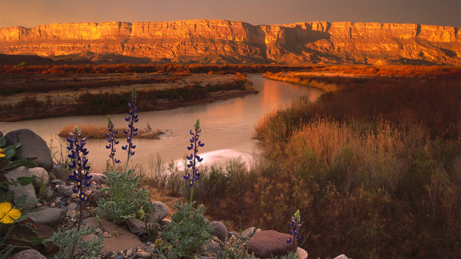
大弯国家公园78岁
加入我们,在美国游客最少的国家公园之一徒步旅行。大弯国家公园可能是美国最大的国家公园之一,面积超过800000英亩(大约相当于罗德岛的面积),但它也是最偏远的国家公园之一。公园入口位于得克萨斯州西部,沿墨西哥边境的格兰德河,距离最近的州际公路大约两小时车程。好消息是,即使是在50万人来访的“繁忙”年份,也有足够的空间来享受美妙的户外活动,不受人群的阻碍。
1944年的今天,大本德被纳入国家公园系统,是美国最大的奇瓦瓦沙漠保护区。它还因拥有邻近各州中最黑暗的夜空而闻名。这使得它成为观星的“必到之地”;当天空晴朗时,数千颗恒星与银河系一起可见。如果你要去远足,一定要留意公园里的1200种植物。这里也有很多动物,尽管它们大多只在晚上出来。就是说,除了鸟。大本德的观鸟活动非常受欢迎,因为每年都有鸟类迁徙,所以这里有450多种不同的鸟类。
波奴鲁鲁国家公园里的邦格尔邦格尔山脉,澳大利亚 Bungle Bungle Range in Purnululu National Park, Australia (© Francesco Riccardo Iacomino/Getty Images)
波奴鲁鲁国家公园里的邦格尔邦格尔山脉,澳大利亚 Bungle Bungle Range in Purnululu National Park, Australia (© Francesco Riccardo Iacomino/Getty Images)
蜂巢状的山脉 Bungle beehives
Bungle Bungle Range in Purnululu National Park, Australia
Aboriginal Australians have lived in this area for more than 20,000 years. But only recently did the rest of the world learn of the otherworldly terrain of the mountains known as the Bungle Bungle Range. In 1982, a nature-documentary crew was filming remote areas within the Kimberley region of Western Australia and 'discovered' the little-known mountain range. Today it is the most popular aspect of Purnululu National Park, a UNESCO World Heritage site.
The Bungle Bungle Range is composed of sandstone domes that can be up to 800 feet tall. Formed by wind and rain over millions of years, the domes get their striking look due to alternating rusty orange bands colored by iron-oxide and grey bands colored by colonies of single-celled microbes called cyanobacteria. Beneath the beehive formations are large pools and caverns, some of which have ancient Aboriginal cave paintings on the walls.
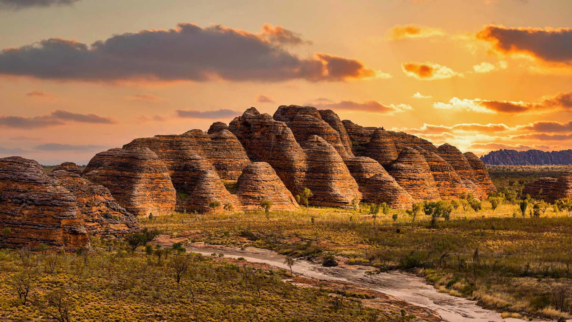
澳大利亚Purnululu国家公园的Bungle Bungle山脉
澳大利亚土著人在这一地区生活了20000多年。但直到最近,世界其他地区才了解到被称为Bungle-Bungle山脉的超凡脱俗的山脉地形。1982年,一个自然纪录片摄制组在西澳大利亚金伯利地区拍摄偏远地区,发现了鲜为人知的山脉。今天,它是联合国教科文组织世界遗产地Purnululu国家公园最受欢迎的部分。
Bungle Bungle山脉由高达800英尺的砂岩圆顶组成。这些圆顶是由数百万年的风雨形成的,由于交替出现由氧化铁着色的锈橙色带和由称为蓝藻的单细胞微生物菌落着色的灰色带,圆顶显得格外引人注目。在蜂巢的下面是大型的水池和洞穴,其中一些墙上有古老的土著洞穴绘画。
科纳提国家公园,克罗地亚 Kornati National Park, Croatia (© Anton Petrus/Getty Images)
科纳提国家公园,克罗地亚 Kornati National Park, Croatia (© Anton Petrus/Getty Images)
适合每个人的岛屿公园 An island park for everyone
European Day of Parks
Enjoy swimming, snorkeling, diving, or sailing? How about soaking in a spectacular natural setting? Croatia's Kornati National Park checks all the boxes. The 84-square-mile park protects 89 islands, islets, and reefs off Croatia's scenic Adriatic Coast.
Today is the European Day of Parks, and we're joining others in taking time to appreciate and support protected natural areas throughout the continent. Kornati, one of Croatia's nine national parks, takes that mission seriously year-round. You can visit Kornati on a day trip from Zadar, an ancient seaside city with a Roman forum and other historic sites. And since 2005, Zadar has had the world's first sea organ, which plays music by way of sea waves and tubes located underneath a set of large marble steps. Many tour boat options offer quick access to the park, some that ply you with local food to enjoy en route. But we suspect you'll want to spend more than a day exploring the island wonders of Kornati National Park. It's an ecotourist's dream.
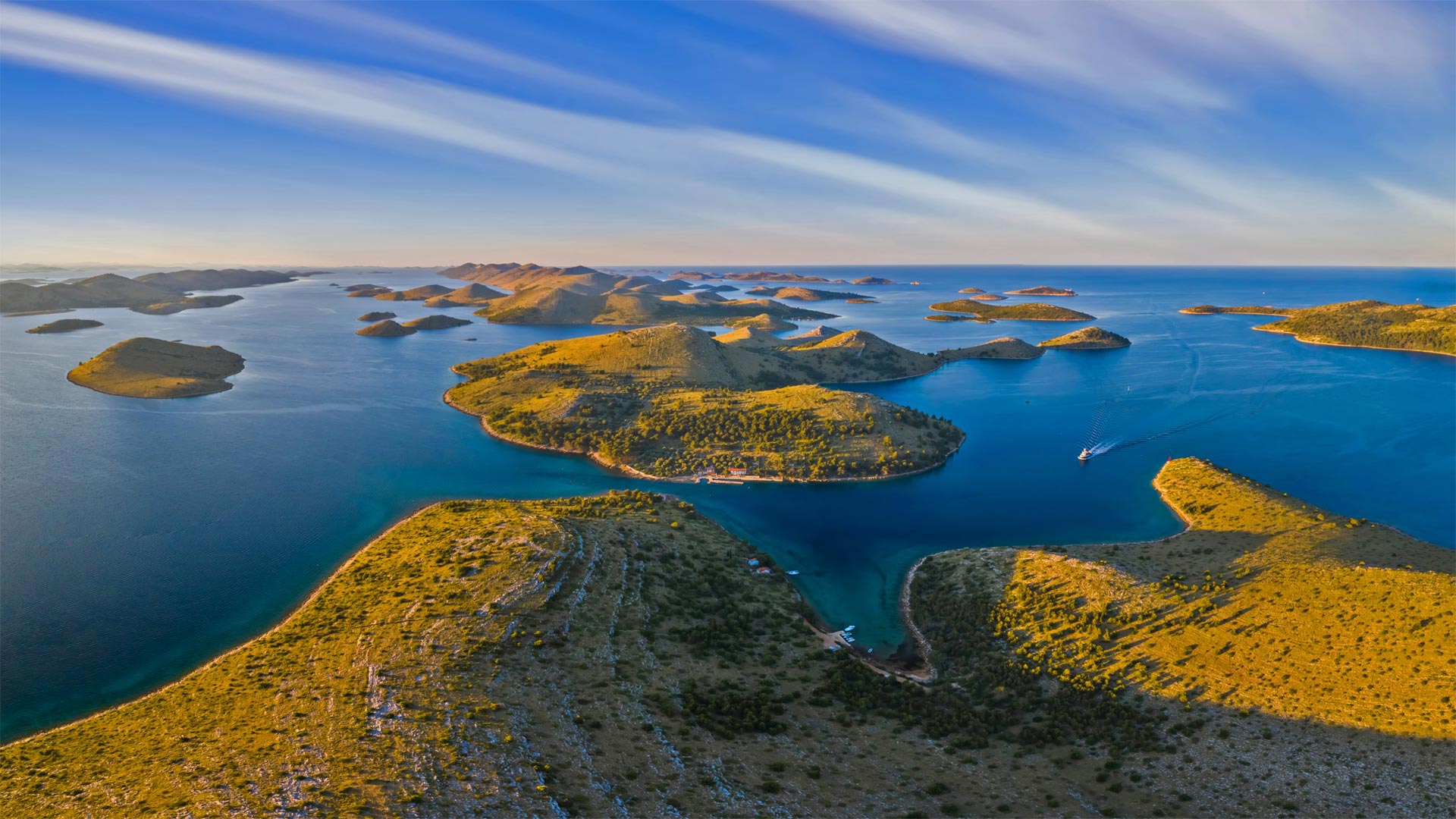
欧洲公园日
喜欢游泳、浮潜、潜水或帆船运动吗?在壮观的自然环境中泡个澡怎么样?克罗地亚的科尔纳蒂国家公园检查了所有的盒子。这个84平方英里的公园保护着克罗地亚风景秀丽的亚得里亚海沿岸的89个岛屿、小岛和暗礁。
今天是欧洲公园日,我们和其他人一起花时间欣赏和支持整个欧洲大陆的自然保护区。科尔纳蒂是克罗地亚九个国家公园之一,全年都认真对待这一使命。你可以从扎达尔(Zadar)一日游到科尔纳蒂,这是一座古老的海滨城市,有罗马论坛和其他历史遗迹。自2005年以来,扎达尔拥有世界上第一个海洋风琴,它通过位于一组大型大理石台阶下的海浪和管子来演奏音乐。许多游船选项都可以快速进入公园,有些还可以在途中为您提供当地美食。但我们怀疑你会想花一天以上的时间探索科纳提国家公园的岛屿奇观。这是生态旅游者的梦想。
布拉塞河上的雾天黎明,英国湖区国家公园 (© fstopphotography/Getty Images)

从观景台俯瞰格雷梅,格雷梅国家公园,土耳其卡帕多西亚省 View of Göreme from an observation deck, Göreme National Park, Cappadocia, Turkey (© Anton Petrus/Getty Images)

从观景台俯瞰格雷梅,格雷梅国家公园,土耳其卡帕多西亚省 View of Göreme from an observation deck, Göreme National Park, Cappadocia, Turkey (© Anton Petrus/Getty Images)
那些生动的岩石 Living rock
Göreme, in Cappadocia, Turkey
Both natural wonders and historic landmarks, the 'fairy chimneys' of Göreme may suggest the fantastical dwellings of an alien species or an illustration from a Dr. Seuss book. These and similar rock formations are known by many names—hoodoos, tent rocks, earth pyramids, as well as fairy chimneys—and are typically found in dry, hot areas. Here in Cappadocia, in south-central Turkey, they were formed when a thick layer of volcanic ash solidified over millions of years into soft, porous rock called tuff that was overlaid by hard basalt. Cracks in the basalt allowed wind and rain to gradually wash away the softer bottom layer, leaving the hard basalt to cap tall columns of the tuff. The result is these unusual, often beautiful—and perhaps puzzling—formations that spread across the Anatolian plain.
This part of modern day Turkey has been inhabited since at least the Hittite era, between 1800 and 1200 BCE, and possibly for much longer. Innumerable ancient empires fought over the region, with Hittites, Assyrians, Neo-Assyrians, Persians, Greeks, and Romans each laying claim to Anatolia at times. To escape this dangerous world, the locals learned to burrow into the hillsides for protection. Today, a visitor can see the vast, complex, interconnected caves in which societies thrived and sheltered for millennia. Göreme National Park was added to the UNESCO World Heritage List in 1985 and is now a popular tourist destination.
格勒梅,土耳其卡帕多西亚
无论是自然奇观还是历史地标,戈雷米的“童话烟囱”都可能暗示着一个外来物种的奇幻住所,或是苏斯博士书中的插图。这些和类似的岩层以许多名字而闻名于世,如树丛、帐篷岩、地球金字塔,以及仙女烟囱,通常出现在干燥炎热的地区。在土耳其中南部的卡帕多西亚,一层厚厚的火山灰经过数百万年的固化,形成了一种叫做凝灰岩的软多孔岩石,上面覆盖着坚硬的玄武岩。玄武岩中的裂缝使风和雨逐渐冲走较软的底层,留下坚硬的玄武岩覆盖凝灰岩的高柱。结果就是这些不寻常的、通常美丽的、也许令人费解的地层遍布安纳托利亚平原。
现代土耳其的这一部分至少从赫梯时代(公元前1800年至1200年)起就有人居住,而且可能会更久。无数的古代帝国为该地区而战,赫梯人、亚述人、新亚述人、波斯人、希腊人和罗马人有时都声称对安纳托利亚拥有主权。为了逃离这个危险的世界,当地人学会了在山坡上挖洞保护自己。今天,游客可以看到巨大、复杂、相互连接的洞穴,数千年来,社会在这些洞穴中繁衍生息并得到庇护。戈雷米国家公园于1985年被联合国教科文组织列入世界遗产名录,现在是一个受欢迎的旅游目的地。