谢南多厄国家公园的秋色,弗吉尼亚州,美国 Fall colors in Shenandoah National Park, Virginia (© Michael Ver Sprill/Getty Images)
谢南多厄国家公园的秋色,弗吉尼亚州,美国 Fall colors in Shenandoah National Park, Virginia (© Michael Ver Sprill/Getty Images)
小径在召唤 The trails' call
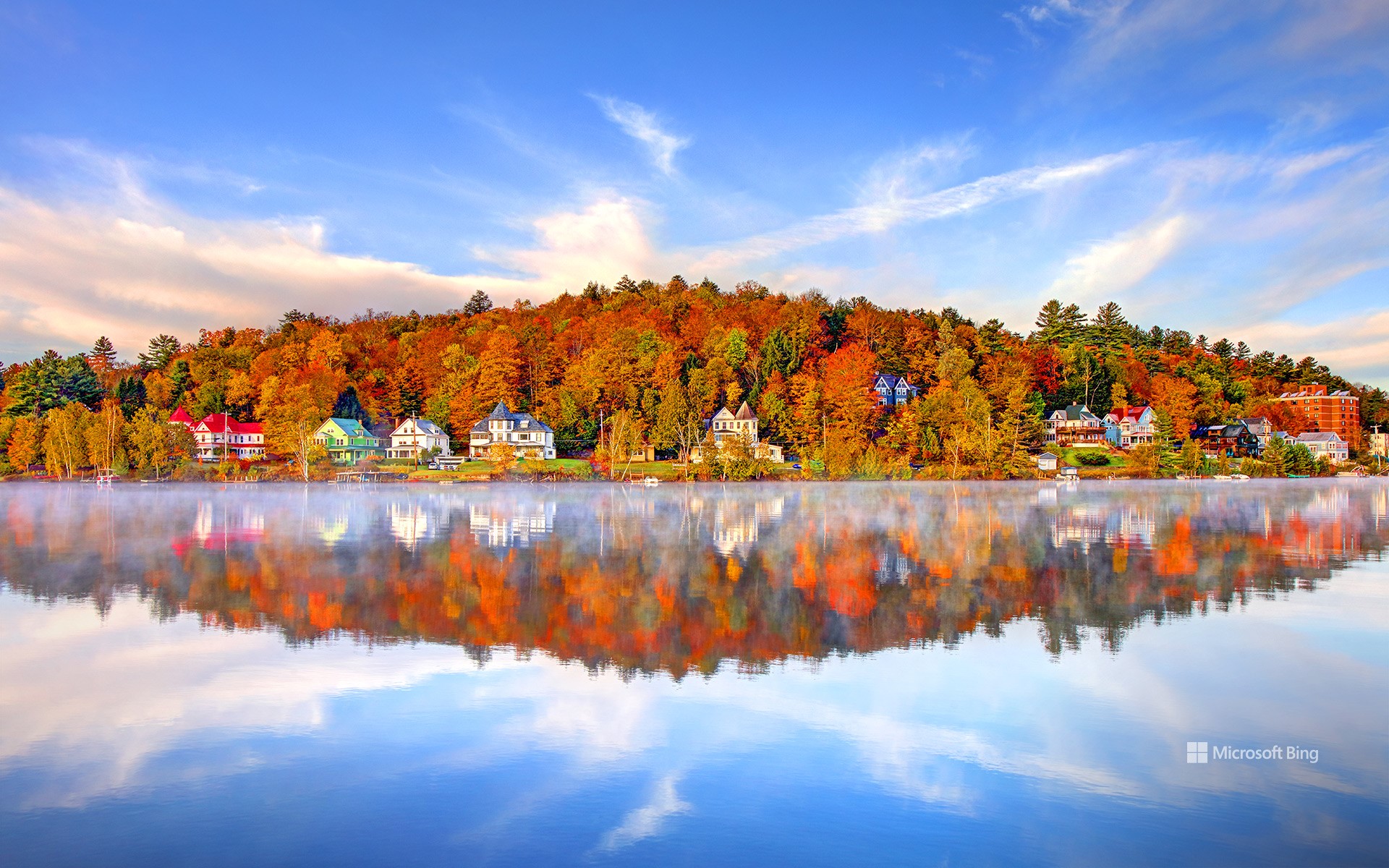
谢南多厄国家公园,弗吉尼亚州,美国
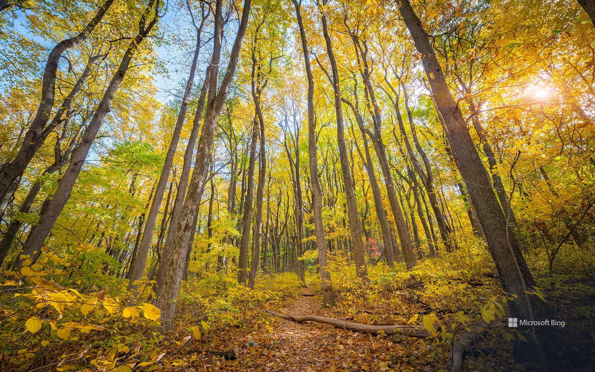
谢南多厄国家公园,弗吉尼亚州的山间瑰宝。蓝岭山脉在此披上最华美的盛装:金黄的山核桃树、绯红的枫树,以及镀上青铜色的橡树。十一月的空气愈发清冽,秋日的余晖低声细语,悄悄停留在山坡上。沿着天际线公路缓缓前行,105英里的蜿蜒公路带你俯瞰云海翻涌,云影在山谷间轻轻流动,像思绪在天空漂移。这里还有超过500 英里的步道,沿着小径,你会走进瀑布奔流的深谷,登上触碰天际的高峰。石人峰、鹰嘴峰、暗谷瀑布——每处皆是石与叶谱写的诗篇,静待游人的脚步与风声共鸣。
National Take a Hike Day
National Take a Hike Day is more than a date—it's an invitation to step away from screens and into the rhythm of nature. Created by the American Hiking Society, this day celebrates the simple act of walking under open skies and reminds us that health and happiness often begin with a single stride. Across 60,000 miles of US trails, hikers rediscover the quiet magic of forests, the strength in their own breath, and the promise of unspoiled landscapes.
And then there's Shenandoah National Park, Virginia's mountain jewel. Here, the Blue Ridge Mountains wear their finest colors—golden hickories, crimson maples, and oaks brushed in bronze. By November, the air turns crisp, and the last embers of fall cling to the hillsides like whispered secrets. Skyline Drive winds for 105 miles, offering vistas where clouds drift like thoughts across endless valleys. Trails—more than 500 miles of them—lead to places where waterfalls tumble and summits greet the horizon. Stony Man, Hawksbill, Dark Hollow Falls—each a poem written in stone and leaf, waiting for footsteps to rhyme with the wind.
班登海滩的海蚀柱,俄勒冈州,美国 Sea stacks of Bandon Beach in Bandon, Oregon (© Grant Ordelheide/TANDEM Stills + Motion)
班登海滩的海蚀柱,俄勒冈州,美国 Sea stacks of Bandon Beach in Bandon, Oregon (© Grant Ordelheide/TANDEM Stills + Motion)
班登的明星岩石 Rock stars of Bandon
俄勒冈州的班登海滩
驶出101号公路,俄勒冈州的班登便迎来了来访者,这里弥漫着咸咸的空气和轻柔的港口钟声。这座小镇始建于19世纪50年代,最初只是个小聚居地,后来发展成为木材和鲑鱼捕捞中心。蔓越莓成为当地的主要作物,至今仍是每年九月蔓越莓节的庆祝活动。老城区的木板路咖啡馆和画廊反映了那段历史,而科基尔河灯塔则矗立在布拉兹海滩,经过修复,依然屹立在那里,提醒着人们当年它曾指引船只的航向。
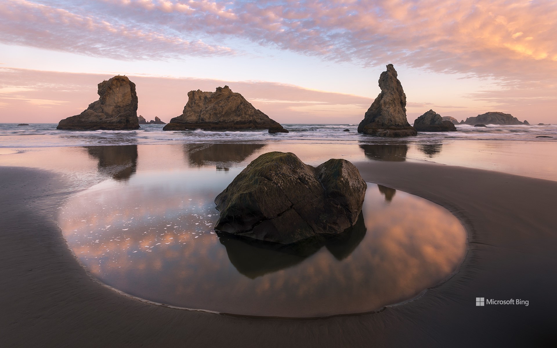
从灯塔步行一小段路即可到达海滩,那里展现着令人回味的海岸景观:班登的海蚀柱,正如今天图片中所展现的那样。这些地貌经过数千年的海浪、风蚀和缓慢崩塌的侵蚀,讲述着一段地质故事。面岩(Face Rock)形似当地传说中少女翘起的下巴。附近的巫师帽(Wizard's Hat)像一顶尖顶的帽子,直冲云霄;大象岩(Elephant Rock)拱起,如同一条伸向潮水的象鼻。其他值得注意的景观包括贝壳角(Coquille Point)、桌岩(Table Rock)以及猫和小猫(Cat and Kittens)海蚀柱。作为俄勒冈群岛国家野生动物保护区的一部分,这些海蚀柱为海鸟提供了庇护,并展现了海洋和时间的坚韧力量。
Bandon Beach in Bandon, Oregon
Pull off of Highway 101, and Bandon, Oregon, greets you with salty air and the clang of harbor bells. The town began as a small settlement in the 1850s and grew into a center for timber and salmon fishing. Cranberries became a key crop and are still celebrated each September during the Cranberry Festival. Old Town reflects that past with boardwalk cafés and galleries, while the Coquille River Lighthouse stands restored at Bullards Beach as a reminder of the days when its beacon guided ships.
A short walk from the lighthouse leads to the beach where an evocative coastal landscape unfolds: Bandon's sea stacks, featured in today's image. Sculpted over millennia by waves, wind, and the slow collapse of arches, these formations tell a geologic story. Face Rock resembles the tilted chin of a maiden from local legend. Nearby, Wizard's Hat rises like a pointed cap against the sky, and Elephant Rock arches like a trunk reaching for the tide. Other notable shapes include Coquille Point, Table Rock, and the Cat and Kittens stacks. Protected as part of the Oregon Islands National Wildlife Refuge, these stones shelter seabirds and reveal the patient force of ocean and time.
野牛在温泉边吃草, 黄石国家公园, 怀俄明州, 美国 Bison grazing at thermal hot springs, Yellowstone National Park, Wyoming (© Cheryl Ramalho/Getty Images)
野牛在温泉边吃草, 黄石国家公园, 怀俄明州, 美国 Bison grazing at thermal hot springs, Yellowstone National Park, Wyoming (© Cheryl Ramalho/Getty Images)
古老血脉的兽群 Herds of heritage
黄石公园的野牛
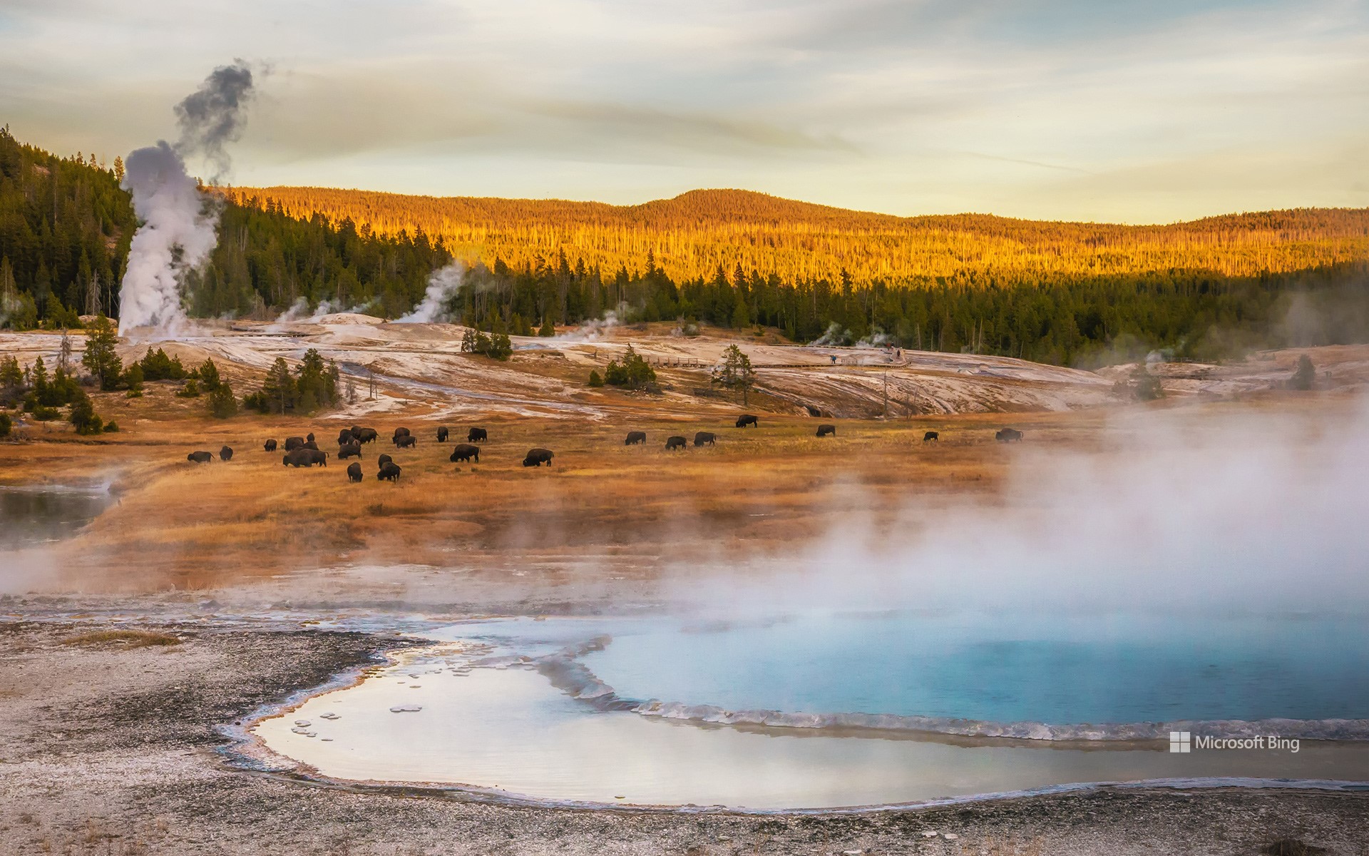
野牛体现了一种矛盾:巨大的力量与沉静的气质并存。这些体型庞大的动物体重可达2000磅,身高6英尺(约1.8米),成群结队地漫游在北美的草原和河谷。这张照片拍摄于怀俄明州的黄石国家公园,它们的数量曾达数千万头,但在19世纪几乎灭绝——这一灭绝事件重塑了生态系统,扰乱了人们的生活方式。
对于无数原住民来说,这些动物一直被尊崇为导师、供养者和精神上的亲人,它们的每一部分都被精心利用,被用作食物、衣物、工具和燃料。正因如此,部落社区带头努力恢复草原、湿地和森林栖息地,形成由母牛、争吵的公牛和好奇的幼牛领导的社会群体。
站在它们面前,感受古老、中断与复兴在一瞬间交汇。野牛的幸存提醒我们,遗产不仅被铭记,它还被传承,交织在崎岖的地貌和经久不衰的传统之中。
National Bison Day
The bison embodies a paradox: immense strength paired with quiet calm. Weighing up to 2,000 pounds and standing 6 feet tall, these giants roam North America's grasslands and river valleys in mobile herds. Photographed here in Yellowstone National Park, Wyoming, they once numbered in the tens of millions but were nearly eradicated in the 19th century—a loss that reshaped ecosystems and disrupted lifeways.
Today, on National Bison Day, observed each year in early November, we honor this iconic species' persistence and profound significance. It's only fitting that this celebration falls at the start of Native American Heritage Month: for countless Native Nations, these animals have been revered as teachers, providers, and spiritual relatives, with every part used thoughtfully for sustenance, clothing, tools, and fuel. That's why tribal communities lead efforts to help them reclaim prairie, wetland, and forest habitats, forming social herds led by matriarchs, sparring males, and curious calves.
玛丽皇后号邮轮的夜景, 长滩, 加利福尼亚州, 美国 Night view of the RMS Queen Mary, Long Beach, California (© Kit Leong/Shutterstock)

玛丽皇后号邮轮的夜景, 长滩, 加利福尼亚州, 美国 Night view of the RMS Queen Mary, Long Beach, California (© Kit Leong/Shutterstock)
从“灰色幽灵”到幽灵传说 From 'Grey Ghost' to ghost stories
玛丽皇后号邮轮的夜景, 长滩, 加利福尼亚州
她注定不会被遗忘。1936年,“玛丽女王号” 首次横渡大西洋时,便夺尽风采。这艘装饰艺术风格的巨轮打破了航速纪录,承载过无数名流、皇室成员与政要。二战期间,她的身份从“海上宫殿”骤然转变为“灰色幽灵”,奢华尽数褪去,取而代之的是装载盟军部队的使命。1967年,航行30年后,她退役停泊在加州长滩。如今,她的甲板化身为酒店走廊、导览展区,成为一座活生生的海事历史纪念碑。
但她的传说并未随锚链一同沉寂。多年来,游客与船员都声称曾在空荡的走廊里听到回声,在金属甲板上听见脚步回荡,甚至在荒废的泳池边传来孩童的笑声。如今的“鬼魂之旅”常常以这些诡异故事为卖点,但历史学家指出,船上所有死亡事件均因自然原因,从未有过谋杀记录。今天的“玛丽女王号”既是历史的地标,也是传说的舞台。那么,她真的闹鬼吗?没有任何档案能够证实,但那些低语般的传闻,依旧让她的故事历久弥新。
Night view of the RMS Queen Mary, Long Beach, California
She was never meant to fade away. When the RMS Queen Mary sailed in 1936, she stole the spotlight across the Atlantic—an Art Deco liner that broke speed records and carried celebrities, royalty, and dignitaries. War transformed her from a floating palace into the 'Grey Ghost,' stripped of luxury and loaded with Allied troops. In 1967, after 30 years at sea, she retired to Long Beach, where her decks now serve as hotel corridors, guided exhibits, and a living monument to maritime history.
But her legend did not dock with her anchors. Over the years, guests and crew have spoken of echoes in empty corridors, footsteps reverberating on metal floors, and the laughter of a child near the deserted pool. Ghost tours highlight these eerie stories, though historians note that deaths aboard were due to natural causes, with no murders ever recorded. Today, the Queen Mary stands as both a heritage landmark and a stage for folklore. So, is she haunted? There are no records confirming it, yet the whispers keep her stories very much alive.
罗克河瀑布,上半岛,密歇根州,美国 Rock River Falls, Upper Peninsula, Michigan (© Matt Anderson Photography/Getty Images)
罗克河瀑布,上半岛,密歇根州,美国 Rock River Falls, Upper Peninsula, Michigan (© Matt Anderson Photography/Getty Images)
爱上密歇根 Falling for Michigan
罗克河瀑布,上半岛,密歇根州
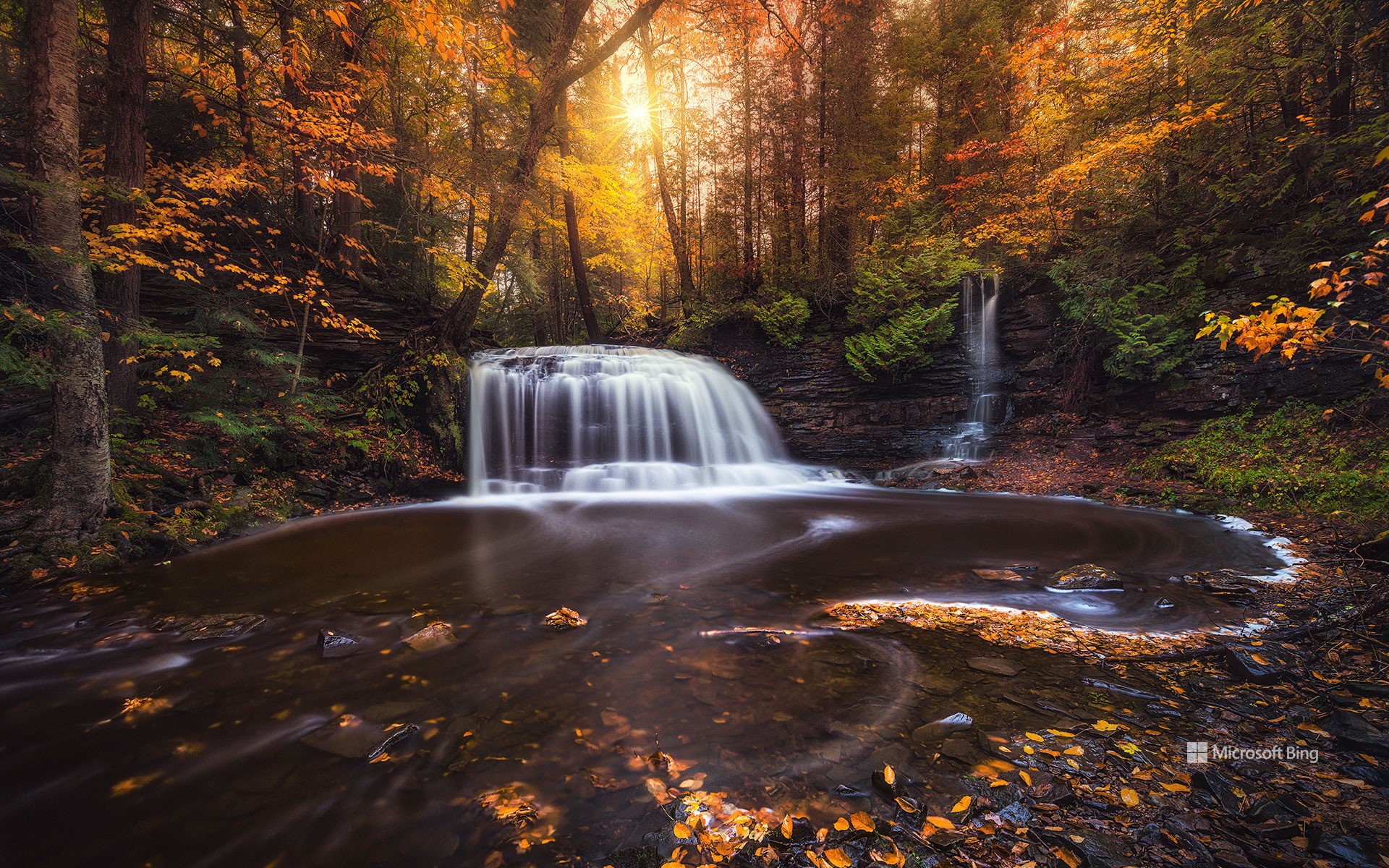
密歇根州罗克河峡谷深处,罗克河瀑布在冰川雕琢的景观中悄然显现,周遭密林环绕,层层历史沉淀。在上半岛这片土地上,人类足迹绵延数千年:原住民阿尔冈昆语族之后,法国与英国探险者接踵而至;19世纪采矿与伐木业繁荣时期,芬兰、瑞典及法裔加拿大移民在此定居。如今这片人烟稀少的区域仅容纳着密歇根州3%的居民,森林与瀑布依旧保留着近乎原始的宁静。
要抵达瀑布,需沿着蜿蜒小径徒步前行,途中松柏参天、枫树成荫,林荫下蕨类与野花尽情舒展。红松鼠穿梭其间,白尾鹿悄然移动,鸥鸟与啄木鸟的鸣叫在海瓦萨国家森林回荡。小径尽头,一道18英尺高的瀑布倾泻而下,汇入清澈水潭。随着季节更替,这里展现出不同的风貌:夏日阳光在水面流转跳跃,秋日将树冠染成绚烂火海,冬日则为岩石披上晶莹冰晶。在罗克河瀑布,每一次造访,都是一次感官与自然灵魂的全新邂逅。
Rock River Falls, Upper Peninsula, Michigan
Nestled within Michigan's Rock River Canyon Wilderness, Rock River Falls emerges amid a landscape shaped by glaciers, dense woods, and layers of history. In the Upper Peninsula, humans have left their traces for millennia: Indigenous Algonquian-speaking peoples were followed by French and British explorers, and waves of Finnish, Swedish, and French-Canadian immigrants settled there during the 19th-century mining and logging booms. Today, this sparsely populated region hosts barely 3% of Michigan's residents, cradling its forests and waterfalls in near-natural serenity.
Reaching the falls requires a moderately challenging hike along winding paths lined with towering pines and maples, their shade cooling the ferns and wildflowers below. Red squirrels dart, white-tailed deer move silently, and the calls of loons and pileated woodpeckers echo through the Hiawatha National Forest. At the trail's end, the 18-foot waterfall spills into a clear pool, transformed by seasonal shifts: summer light flickers across the water, autumn sets the canopy ablaze, and winter drapes ice over rocks in glistening formations. At Rock River Falls, each visit offers a fresh sensory journey through the wild soul of northern Michigan.
萨拉纳克湖村,阿迪朗达克山脉,纽约州,美国 Village of Saranac Lake, Adirondack Mountains, New York (© DenisTangneyJr/Getty Images)
萨拉纳克湖村,阿迪朗达克山脉,纽约州,美国 Village of Saranac Lake, Adirondack Mountains, New York (© DenisTangneyJr/Getty Images)
爱上萨拉纳克 Falling for Saranac
萨拉纳克湖村,纽约州
有些地方只是地图上的一个点,但萨拉纳克湖却是一年四季都吸引游客的热门目的地。尽管名字里带“湖”,这个小镇并不直接坐落在萨拉纳克湖群边,而是位于萨拉纳克河的一段宽阔水域——弗劳尔湖畔。几个世纪以来,这片被称为“阿迪朗达克之都”的地方,一直是原住民狩猎和迁徙的要地。到19世纪末,这里因成为疗养胜地而声名鹊起,爱德华·李文斯顿·特鲁多医生在此开创了肺结核的新鲜空气疗法。那一时期的“疗养小屋”至今依然保存完好。
如今,萨拉纳克湖早已从治病救人转变为治愈无聊的好去处。游客们可以在水道上划桨,攀登高峰,冬天则能体验滑雪和冰钓的乐趣。村子里也同样充满艺术气息,画廊、音乐和社区节庆让文化与户外活动同样重要。本地的商店和餐馆更为旅程增添滋味,从新鲜鳟鱼到精酿啤酒应有尽有。每年举办的冬季嘉年华是最大亮点,其中的冰宫仿佛出自冰雪童话,足以证明这个小镇很懂得如何留下“酷”的印象——不论是氛围,还是温度。
Village of Saranac Lake, New York
Some places are just stops on the map, but Saranac Lake in New York's Adirondack Mountains is a destination that keeps people hooked year-round. Despite its name, this village isn't directly on the Saranac Lakes themselves but rather on Lake Flower, a wide section of the Saranac River. For centuries, the area—nicknamed 'The Capital of the Adirondacks'—was used by Indigenous peoples for hunting and travel. By the late 19th century, it gained fame as a health retreat, where Dr. Edward Livingston Trudeau pioneered fresh-air treatment for tuberculosis. The cure cottages from that era still stand today.
Today, Saranac Lake has shifted from curing patients to curing boredom. Visitors paddle the waterways, hike the High Peaks, and enjoy winter activities like skiing and ice fishing. The village also boasts a lively arts scene, with galleries, music, and community festivals making culture as central as the outdoors. Local shops and restaurants add flavor, serving everything from trout to craft beer. The annual Winter Carnival is a highlight, complete with an ice palace that looks like something out of a frosty fairy tale, proving this village knows how to make a cool impression—literally.
里奇韦附近斯内弗尔斯山脚下的秋色, 科罗拉多州, 美国 Fall colors below Mount Sneffels near Ridgway, Colorado (© Grant Ordelheide/TANDEM Stills + Motion)
里奇韦附近斯内弗尔斯山脚下的秋色, 科罗拉多州, 美国 Fall colors below Mount Sneffels near Ridgway, Colorado (© Grant Ordelheide/TANDEM Stills + Motion)
金色的秋日余晖 Golden fall glow
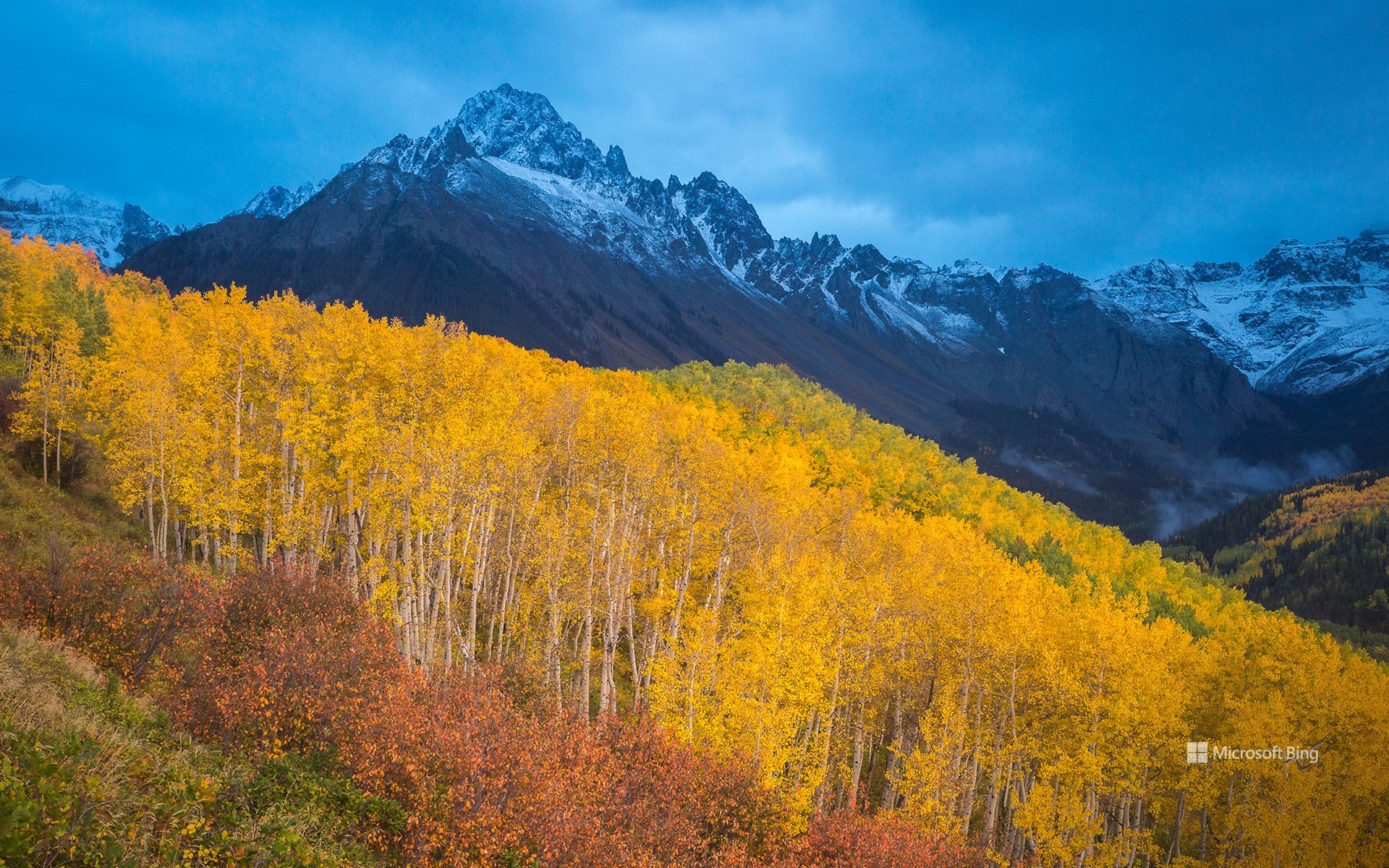
斯内弗尔斯山脚下的秋色, 科罗拉多州, 美国
又到了一年之中,山峦褪去夏日青翠,披上绚烂秋色的时节。变色通常始于九月初至十月初,高处山坡率先染上秋意,随后低处山谷渐次跟进。白杨树堪称这场视觉盛宴的主角,其叶片在阳光下闪烁,宛如金币般熠熠生辉。然而白杨的绚烂并非年年如约而至。它们的色彩取决于多重因素——树木健康状况、局部气候变化、土壤湿度,以及生长海拔与纬度。健康的白杨林才是真正的季节主角:枝繁叶茂的林群色彩更明亮,落叶也更晚;而受压或衰弱的树木往往迅速褪色,只留下一抹短暂的辉煌。去年令人惊艳的景致,今年或许黯淡无光。今日镜头捕捉到斯内弗尔斯山麓的绚烂盛景——这座科罗拉多州斯内弗尔斯山脉的最高峰,从里奇韦镇拔地而起,海拔拔高逾7000英尺。
Fall colors below Mount Sneffels near Ridgway, Colorado
It's that time of year when the hills shed their summer greens, unveiling a blaze of colors that lights up the season. The change usually begins in September and early October, with higher slopes turning first, followed by the lower valleys. Among the stars of this display are the aspens, whose leaves shimmer like gold coins in the sunlight. The magic of aspen colors, however, isn't guaranteed year after year. Their golden glow depends on many factors—tree health, local weather shifts, soil moisture, and where they grow in terms of elevation and latitude. Healthy aspens are the true stars of the season: strong, thriving groves burst with brighter colors and hold onto their leaves longer, while stressed or weakened trees often fade quickly, offering only a glimpse of their usual brilliance. Today's image captures their full glow at the base of Mount Sneffels, the highest peak in Colorado's Sneffels Range, rising more than 7,000 feet above the town of Ridgway.
蛇河上的牛轭湖, 大提顿国家公园, 怀俄明州, 美国 Oxbow Bend on the Snake River, Grand Teton National Park, Wyoming (© DanitaDelimont.com/AWL Images/SuperStock)
蛇河上的牛轭湖, 大提顿国家公园, 怀俄明州, 美国 Oxbow Bend on the Snake River, Grand Teton National Park, Wyoming (© DanitaDelimont.com/AWL Images/SuperStock)
法定自然区 Wild by law
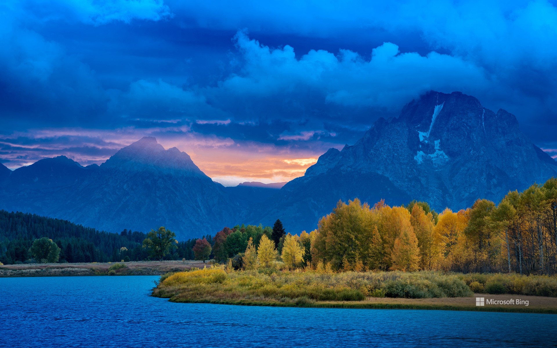
蛇河上的牛轭湖, 大提顿国家公园, 怀俄明州
除了水,河流还承载着生命、历史和故事。它们是大自然对我们景观的永恒贡献,流淌过大地,跨越时间。蜿蜒流经怀俄明州大提顿国家公园的蛇河便是其中一颗瑰宝。这条河上一个尤为令人惊叹的景点是牛轭湖湾——今天这张照片中就出现了——平静的水面倒映着巍峨的提顿山脉,驼鹿和白头鹰等野生动物在这里繁衍生息。在这里,河水自由流淌,不受混凝土或商业的束缚,受到1968年今天签署的《野生与风景河流法案》的保护。
这项具有里程碑意义的法律是一项承诺:有些河流将永远奔腾不息。它守护着那些拥有“非凡之美”的水域,守护着生态和精神——歌唱着荒野,低语着遗产的河流。蛇河源头,包括牛轭湾,于2009年被列入这份神圣名单,确保其倒影不受干扰,韵律不被打破。
黎明时分,薄雾在河湾处舞动,群山沐浴在晨曦的余晖中。游客驻足,静静地欣赏着大自然的诗意。多亏了这项法案,这条河的故事得以流淌——未受驯服,未受污染,令人难忘。
Oxbow Bend on the Snake River, Grand Teton National Park, Wyoming
Beyond water, rivers carry life, history, and stories. They are nature's ever-moving contribution to our landscapes, flowing through lands and across time. One such gem is the Snake River, which winds through Grand Teton National Park in Wyoming. A particularly stunning spot along this river is Oxbow Bend—featured in today's image—where calm waters reflect the towering Teton Range, and wildlife such as moose and bald eagles thrive. Here, water flows freely, unbound by concrete or commerce, protected by the Wild and Scenic Rivers Act, signed on this day in 1968.
This landmark law is a promise: that some rivers shall run wild forever. It safeguards waters with 'outstandingly remarkable' beauty, ecology, and spirit—rivers that sing of wilderness and whisper of heritage. The Snake River Headwaters, including Oxbow Bend, joined this sacred list in 2009, ensuring its reflections remain undisturbed and its rhythms unbroken.
At dawn, mist dances over the bend, and the mountains blush with the first light. Visitors pause, hushed by nature's poetry. Thanks to this Act, the river's story flows on—untamed, unspoiled, unforgettable.
克拉克山脉, 内华达山脉, 约塞米蒂国家公园, 加利福尼亚州, 美国 Clark Range, Sierra Nevada, Yosemite National Park, California (© Robb Hirsch/TANDEM Stills + Motion)
克拉克山脉, 内华达山脉, 约塞米蒂国家公园, 加利福尼亚州, 美国 Clark Range, Sierra Nevada, Yosemite National Park, California (© Robb Hirsch/TANDEM Stills + Motion)
克拉克山脉的回声 Echoes from the Clark Range
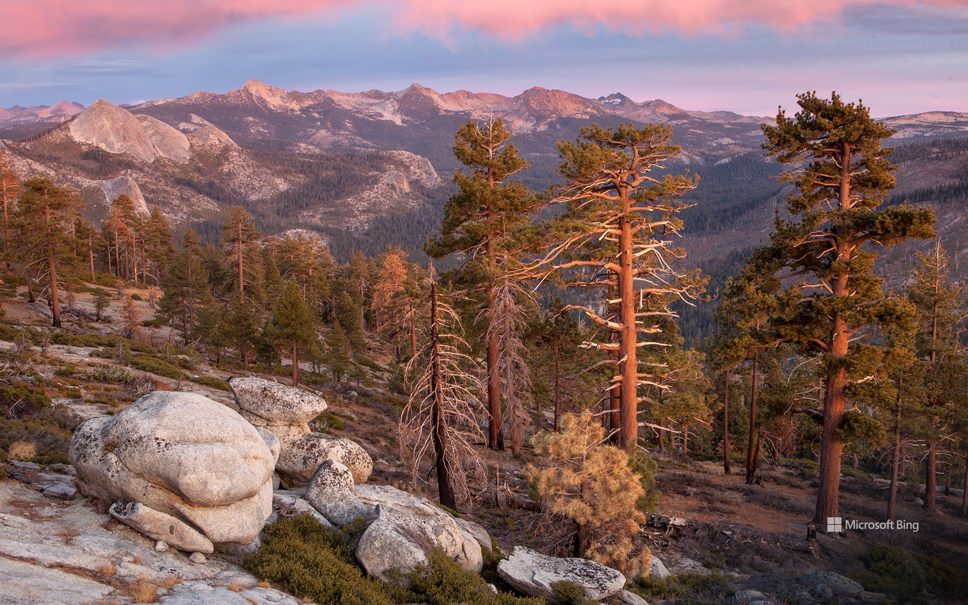
克拉克山脉, 约塞米蒂国家公园, 加利福尼亚州
今年是约塞米蒂国家公园遗产的又一个里程碑。约塞米蒂国家公园自1864年以来一直受到保护,以其令人惊叹的壮丽景色和生态意义而闻名。约塞米蒂坐落在内华达山脉的中心地带,占地近1200平方英里,孕育着巨大的花岗岩、奔腾的瀑布和古老的红杉。克拉克山脉是其鲜为人知的瑰宝之一——今天照片中显示的崎岖高海拔山脊。它以约塞米蒂的第一位守护者、自然保护先驱盖伦·克拉克的名字命名。
克拉克山脉静静地守护着约塞米蒂南部的荒野,其山峰被冰川侵蚀,顶部覆盖着高山草甸。这里,微风轻拂白皮松,天空开阔,呼应着公园诞生时的远见卓识。
Clark Range, Yosemite National Park, California
This year marks another milestone in the legacy of Yosemite National Park, a sanctuary protected since 1864 and celebrated for its awe-inspiring grandeur and ecological significance. Nestled in the heart of the Sierra Nevada, Yosemite's nearly 1,200 square miles cradle granite giants, cascading waterfalls, and ancient sequoias. Among its lesser-known treasures lies the Clark Range—the rugged, high-elevation spine seen in today's image. It was named after Galen Clark, Yosemite's first guardian and a pioneer of conservation.
The Clark Range stands as a quiet sentinel to Yosemite's southern wilderness, its peaks etched by glaciers and crowned with alpine meadows. Here, the wind whispers through whitebark pines and the sky opens wide, echoing the spirit of foresight that birthed the park.
As we honor Yosemite's anniversary, we celebrate not only its grandeur but the enduring vision of those who fought to preserve it. From the valley's granite walls to the Clark Range's serene heights, this national park remains a living poem—written in stone, water, and time.
坦克湖 (Tank Lakes), 高山湖泊荒野区, 华盛顿州, 美国 Tank Lakes, Alpine Lakes Wilderness, Washington (© Austin Trigg/TANDEM Stills + Motion)
坦克湖 (Tank Lakes), 高山湖泊荒野区, 华盛顿州, 美国 Tank Lakes, Alpine Lakes Wilderness, Washington (© Austin Trigg/TANDEM Stills + Motion)
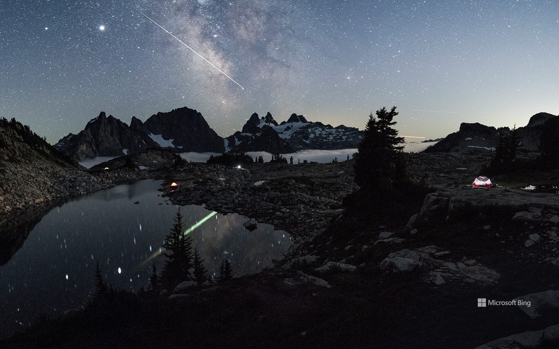
美丽的星空 Weeding and wishing
坦克湖, 高山湖泊荒野区, 华盛顿
今天图片中璀璨的星空来自于坦克湖,它位于高山湖泊荒野区。高山湖泊荒野占地超过40万英亩,位于风景如画的华盛顿州中部喀斯喀特山脉。荒野位于喀斯喀特山脉北段的斯诺夸米山口和史蒂文斯山口之间,其中包括被称为韦纳奇山脉的子山脉,该山脉构成了韦纳奇-雅基马分水岭。
这片荒野由冰川侵蚀而成,点缀着700多个湖泊。许多山峰和山坡终年被雪原覆盖。从生长着花旗松、雪松的湿润森林,到生长着沙拉树和浆果的林下层,这片地貌逐渐延伸至低矮植物覆盖的广阔草甸,最终以生长着黄松的干燥林地结束。
Astronomy Day and National Public Lands Day
When the calendar lines up just right, you get a rare double feature: National Public Lands Day and Astronomy Day. It's a chance to explore the landscapes that ground us and the skies that inspire us—all within 24 hours.
National Public Lands Day, held on the fourth Saturday of September, is America's biggest single-day volunteer event for parks, forests, and other shared spaces. Volunteers rake, plant, and pick up litter—all while enjoying free admission to these sites. Astronomy Day comes twice a year, with the fall version offering longer nights and darker skies. The goal is simple: help more people discover the universe. Many parks are far from city lights, making them prime spots for seeing the Milky Way, meteor showers, and constellations without interference. Remote places like Tank Lakes in Washington's Alpine Lakes Wilderness, pictured here, offer exactly that.
This year, why not make it a two-for-one celebration? Hike a trail by day, then trace constellations by night. On National Public Lands Day, you might cross paths with a deer or eagle. On Astronomy Day, your companions could be Orion or Cassiopeia. Different worlds, same sense of wonder.