瓦卡托比国家公园,印度尼西亚 Wakatobi National Park, Indonesia (© Fabio Lamanna/Alamy)
瓦卡托比国家公园,印度尼西亚 Wakatobi National Park, Indonesia (© Fabio Lamanna/Alamy)
Diving into the 'underwater nirvana'
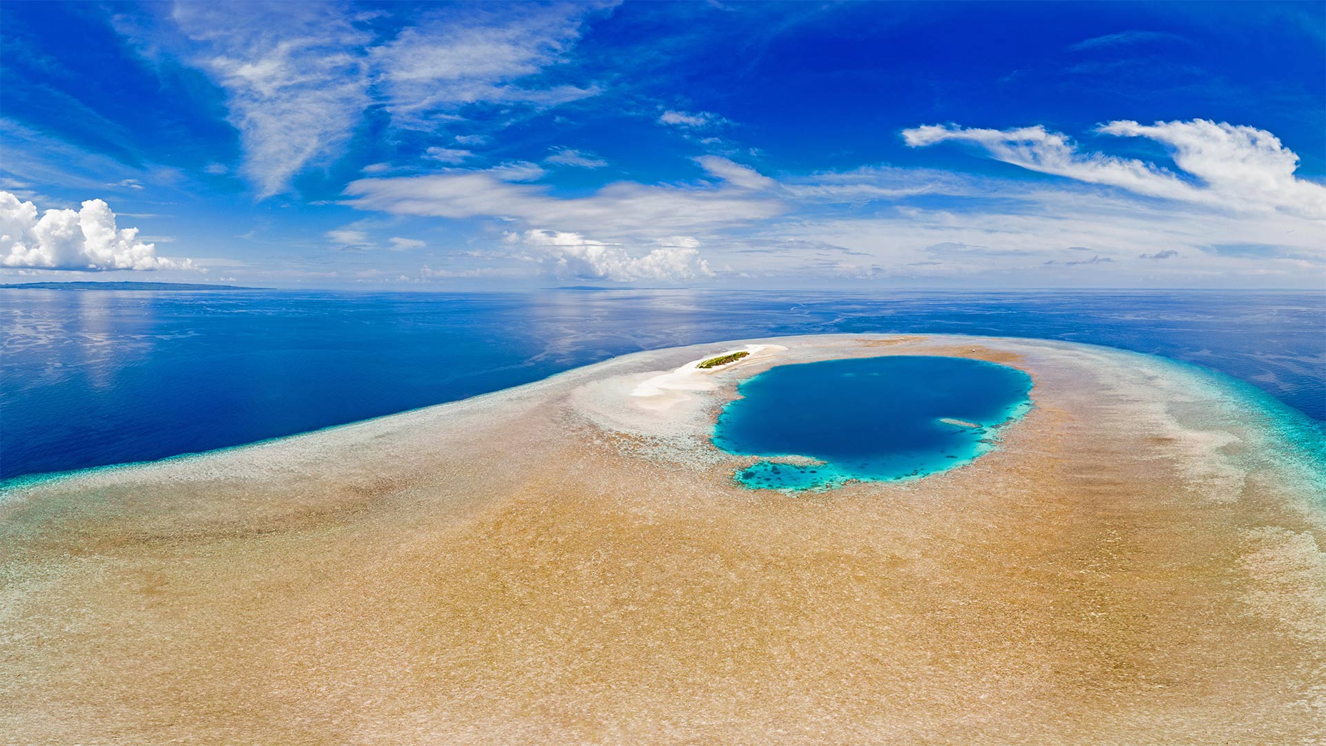
Indonesia's Wakatobi National Park protects one of the most diverse underwater environments in the world. Around 400 species of coral are found in these pristine waters, and they're home to a staggering variety of marine life, including dolphins, whales, turtles, and hundreds of species of fish. The park was established in 2002, preserving more than 5,000 square miles, most of which is covered by coral reefs. In fact, the barrier reef here is second in size only to the Great Barrier Reef and is so full of life that famed oceanographer and explorer Jacques Cousteau is said to have called it an 'underwater nirvana.' Many others have followed in Cousteau's wake, and Wakatobi has become a preeminent destination for diving and snorkeling.
潜入“水下涅盘”
印尼的瓦卡托比国家公园保护着世界上最多样化的水下环境之一。在这些原始水域中发现了大约400种珊瑚,它们是各种海洋生物的家园,包括海豚、鲸鱼、海龟和数百种鱼类。该公园成立于2002年,保护面积超过5000平方英里,其中大部分被珊瑚礁覆盖。事实上,这里的大堡礁面积仅次于大堡礁,充满了生命,据说著名的海洋学家和探险家雅克·库斯托(Jacques Cousteau)将其称为“水下涅磐”。许多其他人跟随库斯托,瓦卡托比已成为潜水和浮潜的卓越目的地。
《迁徙通道》乔治亚·沃尔佩的一个艺术装置, 魁北克市加拿大 'Passage migratoire' ('Migratory Passage'), an art installation by Giorgia Volpe in Old Québec City, Québec, Canada (© Lucbouch/Getty Images)

《迁徙通道》乔治亚·沃尔佩的一个艺术装置, 魁北克市加拿大 'Passage migratoire' ('Migratory Passage'), an art installation by Giorgia Volpe in Old Québec City, Québec, Canada (© Lucbouch/Getty Images)
Celebrating migrations on Canada's national day
For Canada Day, we're peering up at 'Passage migratoire' ('Migratory Passage'), an art installation of hanging braided canoes in Old Québec City. It was part of the 2016 edition of Passages Insolites (Unusual Passages), an annual public art exhibition in the historic Petit Champlain and Saint-Roch districts of the city. The canoe has long been associated with Canada's national history, linked with early explorers, fur traders, Indigenous peoples, and colonists who ventured out into the wilderness of the great north. The artist behind this installation, Giorgia Volpe, was inspired by 'the idea of migration and its influence on the formation of our society and our territory.' Canada welcomes on average about 200,000 immigrants each year, many of whom will become Canadian citizens.
在加拿大国庆日庆祝移民
为了庆祝加拿大日,我们要去参观“迁徙通道”(passion migratoire),这是一个古老的曲城悬挂编织独木舟的艺术装置é贝克市。这是2016年版的“圣殿圣殿(不寻常的圣殿)”的一部分,这是一个在历史悠久的小尚普兰和圣罗什地区举办的年度公共艺术展。独木舟长期以来一直与加拿大的国家历史联系在一起,与早期探险家、毛皮商人、土著人民和冒险进入大北方荒野的殖民者联系在一起。这套装置背后的艺术家乔治·沃尔佩(Giorgia Volpe)的灵感来自“移民的理念及其对我们社会和领土形成的影响”。加拿大平均每年欢迎约20万移民,其中许多人将成为加拿大公民。
Ardnamurchan半岛, 苏格兰高地 (© Cavan Images/Offset by Shutterstock)
Manicouagan火山口, 魁北克加拿大 Manicouagan Crater in Québec, Canada (© Universal History Archive/Universal Images Group via Getty Images)
Manicouagan火山口, 魁北克加拿大 Manicouagan Crater in Québec, Canada (© Universal History Archive/Universal Images Group via Getty Images)
An impactful day
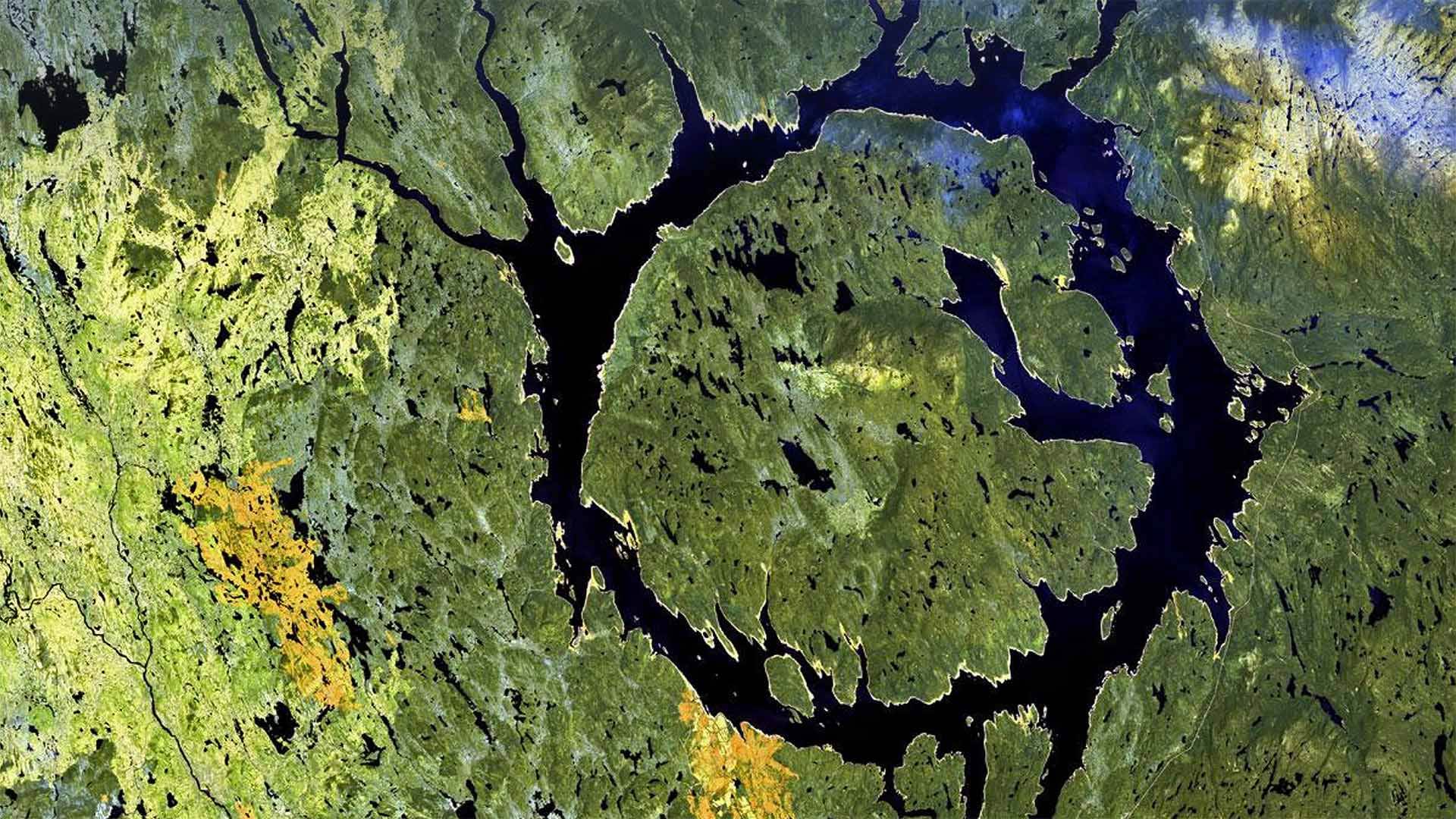
We'll be the ones to drop the news on you: It's Asteroid Day! Today you're invited to explore a realm of science usually encountered only through white-knuckle action flicks: Asteroid impact avoidance, or the study of what the heck we do if we spot a big chunk of space junk hurtling right at Earth. That's right, don't worry: People somewhere are coming up with plans for this.
Good thing, because as our photo shows, asteroid impacts do happen. Manicouagan Crater, aka the 'eye of Québec,' was formed by a 3-mile-wide meteorite that hit Earth about 215 million years ago. Much more recently, an explosive meteoroid leveled 800 square miles of Siberian forest in what's called the Tunguska event. It was 113 years ago today, and Asteroid Day's date was chosen in recognition.
So, if you find yourself casting paranoid glances at the sky today, maybe do a little searching on how scientists are learning to prevent potential impacts. Proposed plans involve everything from altering an asteroid's course via a gravitational field, to delaying its approach by attaching rocket thrusters, to good old-fashioned blowing it up. Yay science!
充实的一天
我们会把这个消息告诉你:今天是小行星日!今天,你被邀请去探索一个科学领域,这个领域通常只能通过白痴般的动作来实现:小行星撞击避免,或者研究如果我们发现一大块太空垃圾正朝地球飞来,我们该怎么办。是的,别担心:某地的人们正在为此制定计划。
好事情,因为正如我们的照片所示,小行星撞击确实发生过。Manicouagan火山口,又名“Qu之眼”é“bec”是由一块3英里宽的陨石形成的,它在大约2.15亿年前撞击地球。最近,在通古斯卡事件中,一个爆炸性流星体将800平方英里的西伯利亚森林夷为平地。那是113年前的今天,小行星日的日期被选为纪念日。
所以,如果你发现自己今天对天空投下了偏执的目光,或许可以做一些探索,看看科学家们是如何学会防止潜在的影响的。拟议中的计划涉及到从通过引力场改变小行星的轨道,到通过安装火箭推进器推迟其接近,再到老式的炸毁小行星的各种方法。耶,科学!
薰衣草田,英国牛津 Lavender fields at lavender farm, Oxfordshire, England (© Peter Greenway/EyeEm/Getty Images)

薰衣草田,英国牛津 Lavender fields at lavender farm, Oxfordshire, England (© Peter Greenway/EyeEm/Getty Images)
The scent of summer
These fragrant purple blooms are a quintessential summer sight - and not just in Provence. Once a favourite in Victorian gardens, homegrown lavender production has seen a renaissance in recent decades, with many small-scale producers growing it and producing lavender-based goods, from creams and oils to cider and chocolate. There are more than 40 different types but Lavendula angustifolia, also known as English lavender, is particularly popular here, especially with bees.
Lavender, which comes from the same family as mint, has been long been a popular plant, associated with cleanliness (the name is thought to have its roots in the Latin verb ‘lavare’ to wash), as well as relaxation and healing. The Ancient Egyptians are thought to have used it in the mummification process, while the Ancient Greeks used it for minor ailments and the Romans used it to clean their clothes. It’s not native to the UK and it is not certain when exactly it arrived on these shores, but it has been popular here for centuries. Lavender is said to have been Queen Elizabeth I’s favourite perfume, posies of lavender were carried and scattered before her to fend off bad smells. More than 200 years later, it was still a royal favourite - Queen Victoria is said to have had a taste for lavender jelly served with roast mutton.
夏日的气息
这些芳香的紫色花朵是典型的夏季景观-不仅仅是在普罗旺斯。曾经是维多利亚花园的宠儿,近几十年来,本土薰衣草生产出现了复兴,许多小规模生产商种植薰衣草,生产薰衣草制品,从奶油和油到苹果酒和巧克力。有40多种不同的类型,但薰衣草,也被称为英国薰衣草,在这里特别受欢迎,尤其是蜜蜂。
薰衣草与薄荷来自同一科,长期以来一直是一种受欢迎的植物,它与清洁(这个名字被认为来源于拉丁语动词“lavare”to wash)以及放松和疗伤有关。古埃及人被认为是在木乃伊制作过程中使用的,而古希腊人用它来治疗小病,罗马人用它来清洗衣服。它不是英国本土的,也不确定它何时到达这些海岸,但它在这里流行了几个世纪。据说,薰衣草是伊丽莎白女王一世最喜欢的香水,一束束薰衣草被带到她面前,撒在她面前,以抵御难闻的气味。200多年后,它仍然是皇室的最爱——据说维多利亚女王尝过薰衣草果冻配烤羊肉。
拉迪格岛德阿让海滩上的岩石,塞舌尔 Rocks on Anse Source d'Argent beach, La Digue Island, Seychelles (© Roland Gerth/eStock Photo)
拉迪格岛德阿让海滩上的岩石,塞舌尔 Rocks on Anse Source d'Argent beach, La Digue Island, Seychelles (© Roland Gerth/eStock Photo)
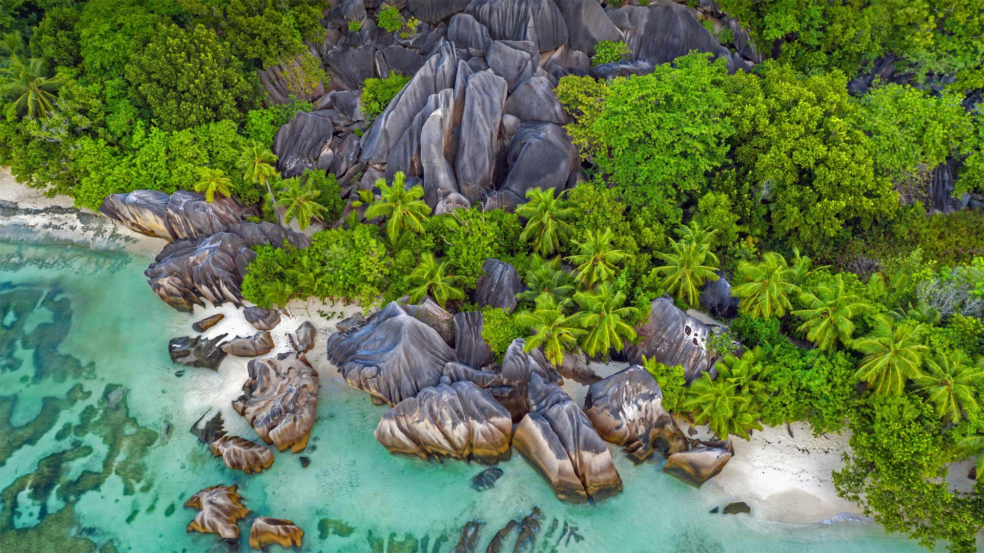
An island hopper's paradise
Welcome to the sunny and sultry Seychelles, a tropical island nation just south of the equator in the Indian Ocean, roughly 900 miles off the eastern coast of Africa. The gorgeous beach you see here is the Anse Source d'Argent on the island of La Digue, one of 115 islands that make up this tropical republic. Anse Source d'Argent has long been a favorite of photographers, who are drawn to its contoured, dark granite boulders, pristine white sand, and turquoise-colored water. Beachcombers and sun worshippers also flock to the Seychelles because of the islands' consistently great weather—daily high temperatures almost always stay within a comfortable range of between 75 and 90 degrees Fahrenheit all year round.
Most any day is a day worth celebrating in the Seychelles, but today is cause for double celebration: June 29 is Independence Day in the Seychelles, commemorating the nation's 1976 independence from centuries of colonial rule under the French and British. It also happens to be the UN's International Day of the Tropics, a day of special recognition for the Seychelles and other locales within the zone between the tropics of Cancer and Capricorn. That accounts for about 36% of Earth's land mass and close to 40% of its population. The intent of International Day of the Tropics is twofold: as a celebration of the extraordinary diversity of this zone while also highlighting the challenges facing the region, like poverty, climate change, deforestation, urbanization, and demographic shifts.
岛上的天堂
欢迎来到阳光明媚、闷热的塞舌尔,这是一个热带岛国,位于印度洋赤道以南,距非洲东海岸约900英里。你在这里看到的美丽海滩是位于拉迪格岛上的安塞岛,它是组成这个热带共和国的115个岛屿之一。安塞源d'Argent一直是摄影师的最爱,他们被它的轮廓,黑色花岗岩巨石,原始的白色沙子,和绿松石色的水所吸引。由于塞舌尔群岛持续的好天气,海滩梳洗者和太阳崇拜者也蜂拥而至,每天的高温几乎全年都保持在75到90华氏度的舒适范围内。
在塞舌尔,任何一天都是值得庆祝的日子,但今天都是值得双重庆祝的日子:6月29日是塞舌尔的独立日,纪念1976年塞舌尔从法国和英国统治下几个世纪的殖民统治中独立出来。这一天恰巧是联合国的国际热带日,塞舌尔和其他位于北回归线和摩羯座之间地区的地区受到特别的表彰。占地球陆地面积的36%,人口的40%。国际热带日的目的有两个:一是庆祝该地区的非凡多样性,同时也强调该地区面临的挑战,如贫困、气候变化、毁林、城市化和人口变化。
戈佐岛上的Cittadella城堡,马耳他 Cittadella on the island of Gozo, Malta (© Davide Seddio/Getty Images)
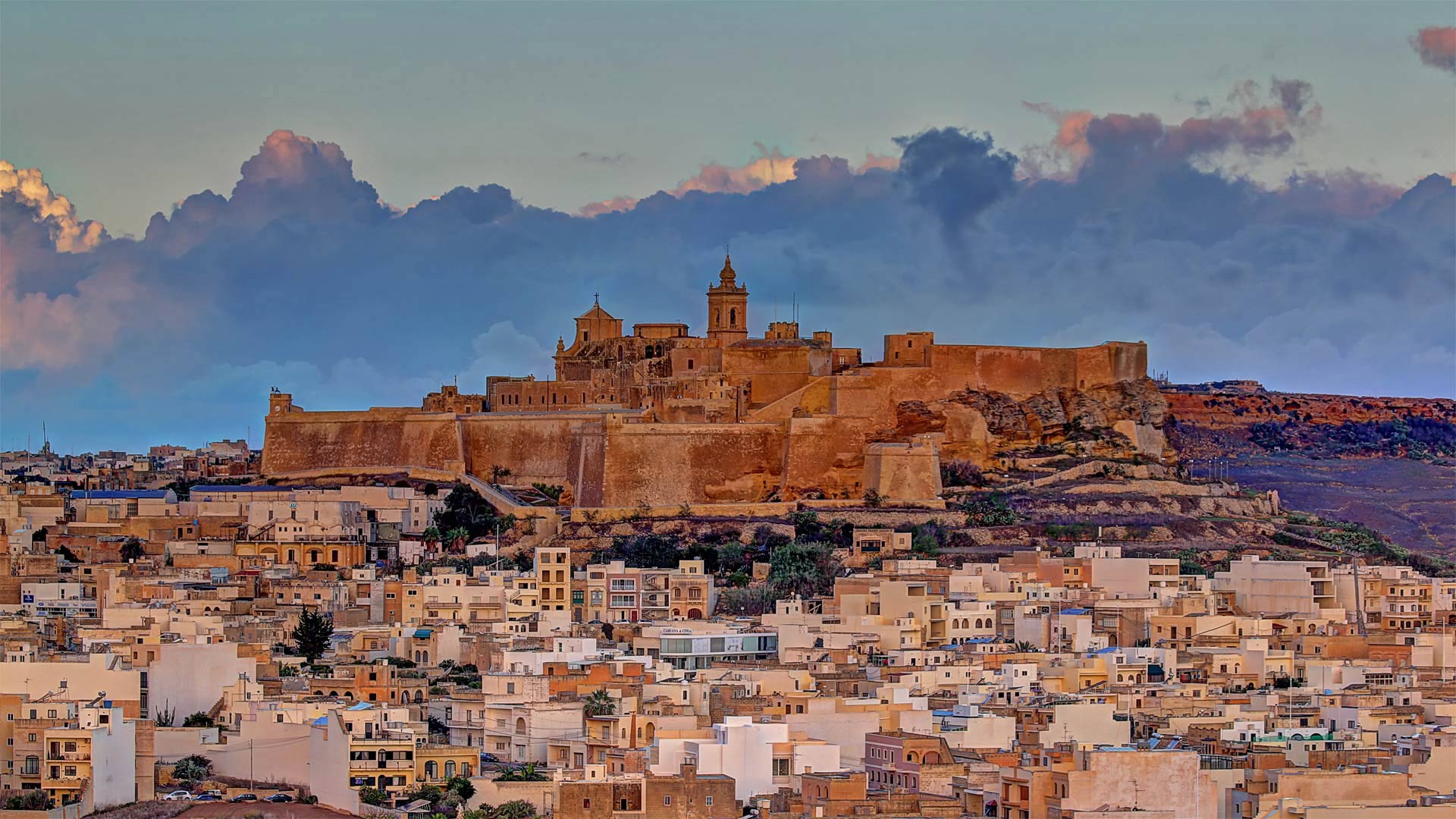
戈佐岛上的Cittadella城堡,马耳他 Cittadella on the island of Gozo, Malta (© Davide Seddio/Getty Images)
A celebration of Maltese culture
That mighty fortress at the top of the hill is called the Cittadella—it's a medieval fortified city at the geographical center of the island of Gozo. Gozo is the second-largest island in the Maltese archipelago (after the island of Malta itself), and despite all appearances it's the less densely populated of the two.
On both Gozo and Malta, today marks the start of a two-day celebration of Maltese culture called Mnarja (sometimes spelled Imnarja). The national festival dates from the 16th century and is dedicated to the feast day of Saints Peter and Paul. During Mnarja, centuries-old Maltese customs and traditions are on full display. The streets come alive with traditional folk songs called ghana, as well as dancing, and horse and donkey races, some of which feature jockeys riding behind in chariots. Malta's national dish, a rabbit stew called fenkata, is served at nearly all Mnarja events. During the festival's medieval origins this was the only time of year when ordinary Maltese people were allowed to eat rabbit, which was usually reserved for the knights that then ruled the islands. To wash down the rabbit stew? Maltese wine, of course. Saħħa! ('Cheers!')
马耳他文化庆典
山顶上那座雄伟的堡垒被称为Cittadella,它是一座中世纪的防御城市,位于戈佐岛的地理中心。戈佐岛是马耳他群岛中的第二大岛(仅次于马耳他岛本身),尽管从表面上看,它是两个岛屿中人口密度较小的一个。
在戈佐和马耳他,今天标志着为期两天的马耳他文化庆祝活动的开始,这一活动被称为Mnarja(有时拼写为Imnarja)。这个国家节日可以追溯到16世纪,是为了纪念圣徒彼得和保罗的节日。在姆纳贾期间,几个世纪以来的马耳他习俗和传统得到充分展示。街道上充满了被称为加纳的传统民歌,还有舞蹈、赛马和驴子赛跑,其中一些是骑师坐在战车后面。马耳他的国菜,一种名为芬卡塔的炖兔肉,几乎在所有的姆纳贾活动中都有供应。在节日起源于中世纪的时候,这是一年中唯一允许普通马耳他人吃兔子的时候,兔子通常是留给当时统治群岛的骑士的。把炖兔肉洗干净?当然是马耳他葡萄酒。萨尼亚!干杯
石林峡风景区玻璃观景台, 中国北京平谷 Glass sightseeing platform in Shilinxia Scenic Area, Pinggu District of Beijing, China (© STR/AFP via Getty Images)
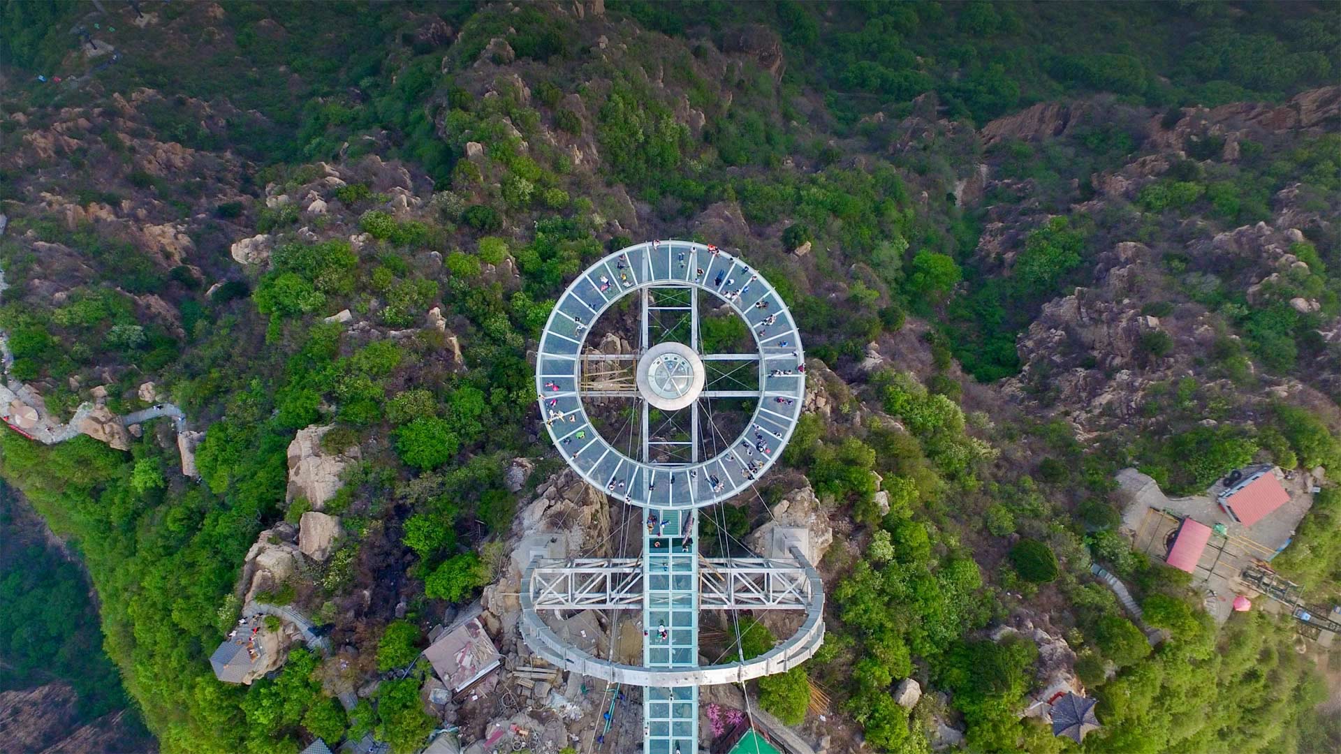
石林峡风景区玻璃观景台, 中国北京平谷 Glass sightseeing platform in Shilinxia Scenic Area, Pinggu District of Beijing, China (© STR/AFP via Getty Images)
Spectacular views below!
When residents of the bustling metropolis of Beijing, China, need a break from their daily grind, many will head about 45 miles north of the city to take in the sights at the Shilinxia Scenic Area. Meaning 'Gorge of Stone Forest,' Shilinxia is a protected 7-and-a-half mile gorge which, since 2016 has featured an amazing main attraction—one of the world's largest glass sightseeing platforms.
If you're scared of heights, this platform may not be for you, as it sits roughly 1,300 feet above the valley floor and juts out nearly 108 feet from the tallest point in the gorge. But don't worry: Even though it may inspire a bit of vertigo and has been known to sway a bit with the wind, the platform is perfectly safe—the glass floor is reinforced by titanium alloys. Once out on the platform, viewers can look down through glass into the rugged sandstone rocks and forest of the Shilinxia gorge below. It's easy to also catch a glimpse of some local landmarks, including the nearby Huangsongyu reservoir, Diaowo Village, and the Shilin River.
下面是壮观的景色!
当中国北京这座繁华都市的居民需要从日常工作中休息一下时,许多人将前往北京以北45英里处的石林峡风景区游览。石林峡的意思是“石林峡谷”,是一个受保护的7.5英里长的峡谷,自2016年以来,石林峡一直是世界上最大的玻璃观光平台之一。
如果你怕高,这个平台可能不适合你,因为它坐落在大约1300英尺以上的谷底和突出近108英尺的最高点在峡谷。但别担心:尽管它可能会引起一点眩晕,而且已知会随风摇摆一点,但平台是完全安全的——玻璃地板由钛合金加固。一旦登上月台,观众可以透过玻璃俯瞰下面石林峡崎岖的砂岩和森林。也很容易看到一些当地的标志性建筑,包括附近的黄松峪水库、刁窝村和石林河。
上高地 日本长野县, Kamikōchi, Nagano Prefecture, Japan (© sadao/Shutterstock)

上高地 日本长野县, Kamikōchi, Nagano Prefecture, Japan (© sadao/Shutterstock)
"Kamikochi" Nagano Prefecture
Kamikochi, located in the valley of the Northern Alps, is a large plateau with abundant greenery. The original kanji is "Kamigakiuchi", and it was named because the deity of Hotaka Shrine, Hotaka Mikoto, descended to Mt. It was. It is also a hot spring resort, and there is also a hot spring inn where you can take a day trip bath ...
At an altitude of 1500 meters, the area has a wet continental climate, with cool summers and cold winters. It is blessed with a variety of vegetation because it extends from the mountainous area to the subalpine zone. The snowy landscape and the fresh green of early summer are wonderful, but the autumn leaves are also wonderful. Forests and lakes are inhabited by ancient Japanese creatures such as Japanese macaques, mallards, and chars.
长野县镰刀町
Kamikochi位于阿尔卑斯山北部的山谷中,是一个拥有丰富绿叶的大高原。原来的汉字是“Kamigakiuchi”,它的名字是因为和田神社的神,和田三谷浩田,下降到山。这也是一个温泉度假村,还有一个温泉旅馆,你可以在那里洗一天澡。。。
该地区海拔1500米,属湿润大陆性气候,夏季凉爽,冬季寒冷。它拥有丰富的植被,因为它从山区延伸到亚高山地带。白雪皑皑的景色和初夏清新的绿意是美妙的,但秋叶也是美妙的。森林和湖泊居住着古老的日本生物,如日本猕猴、野鸭和沙鼠。
德纳利国家公园和自然保护区的驯鹿,阿拉斯加 Caribou in Denali National Park and Preserve, Alaska (© Design Pics/Danita Delimont)
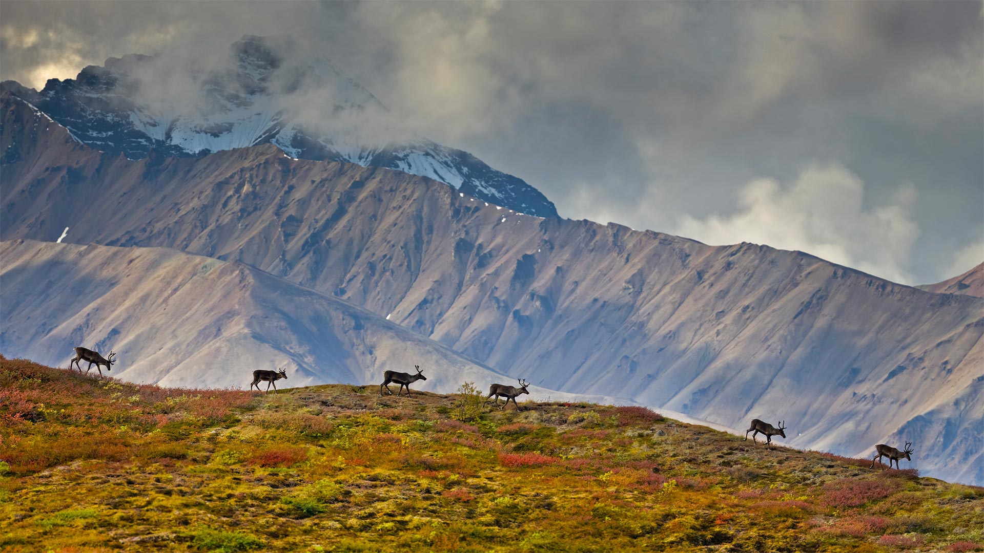
德纳利国家公园和自然保护区的驯鹿,阿拉斯加 Caribou in Denali National Park and Preserve, Alaska (© Design Pics/Danita Delimont)
The call of the wild in Alaska
Most visitors to Denali National Park and Preserve in Alaska come with a checklist for the 'big five' mammals that live here: Grizzly bears, moose, wolves, Dall sheep, and caribou like this small group walking along a ridge. These are barren-ground caribou, a migratory subspecies of caribou found across the arctic band of North America to western Greenland. Barren-ground caribou migrate in large herds, some traveling over 600 miles one way, between their summer and winter ranges. But the Denali herd, today which numbers around 3,000 animals, generally stay on the park's 6 million acres. For good reason, too—they're the only large herd that aren't hunted.
阿拉斯加野性的呼唤
大多数到德纳利国家公园和阿拉斯加自然保护区的游客都会带上一份居住在这里的“五大”哺乳动物的清单:灰熊、驼鹿、狼、大头羊和驯鹿,就像这一小群沿着山脊行走的动物一样。这些是贫瘠的地面驯鹿,驯鹿的一个迁徙亚种,发现于北美洲北极带到格陵兰岛西部。贫瘠的地面驯鹿成群结队地迁徙,有些驯鹿在夏季和冬季之间单程旅行600英里。但如今的德纳利兽群大约有3000头,它们一般都生活在公园的600万英亩土地上。也有很好的理由,它们是唯一没有被猎杀的大型兽群。