谢南多厄国家公园的秋色,弗吉尼亚州,美国 Fall colors in Shenandoah National Park, Virginia (© Michael Ver Sprill/Getty Images)
谢南多厄国家公园的秋色,弗吉尼亚州,美国 Fall colors in Shenandoah National Park, Virginia (© Michael Ver Sprill/Getty Images)
小径在召唤 The trails' call
谢南多厄国家公园,弗吉尼亚州,美国
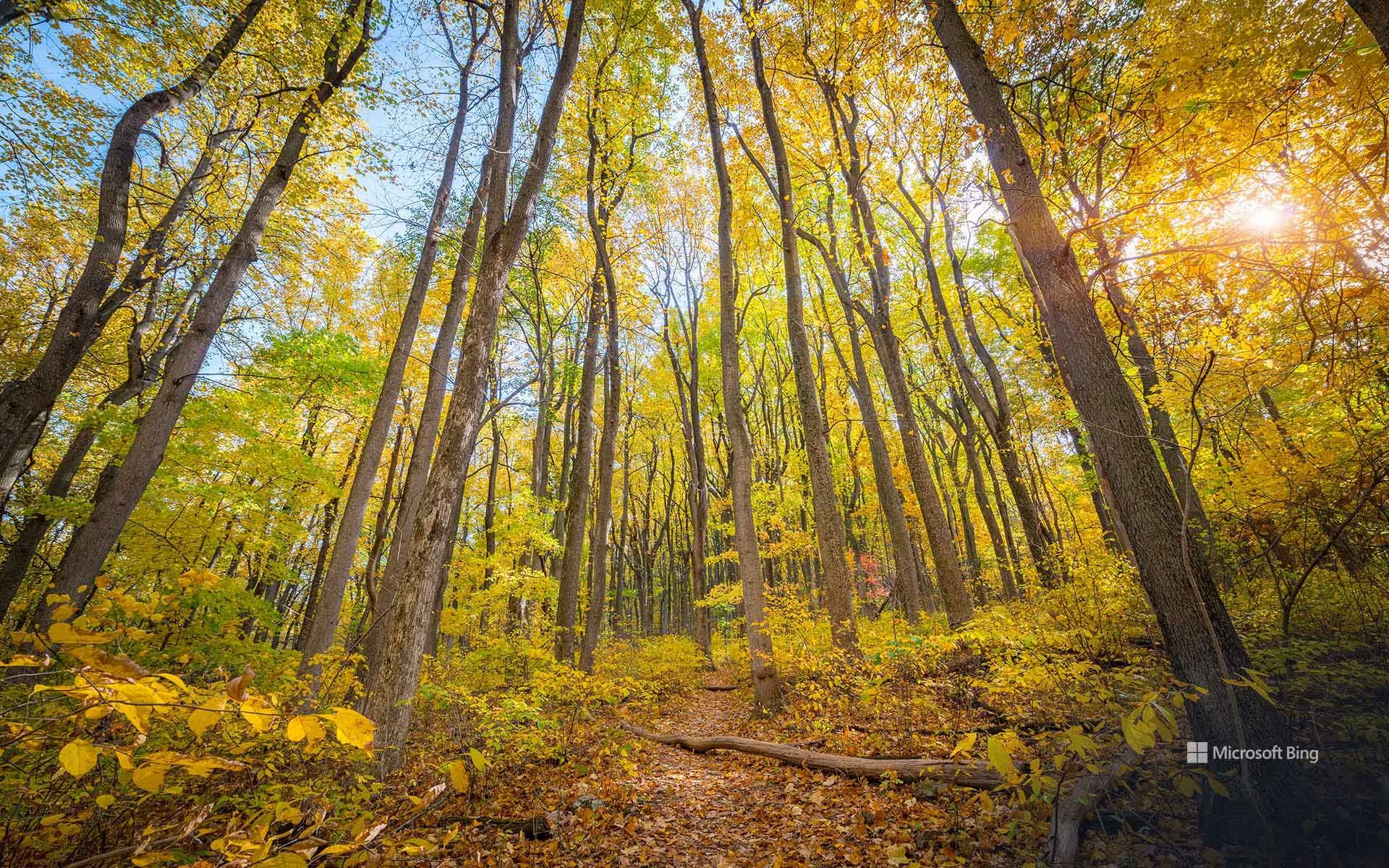
谢南多厄国家公园,弗吉尼亚州的山间瑰宝。蓝岭山脉在此披上最华美的盛装:金黄的山核桃树、绯红的枫树,以及镀上青铜色的橡树。十一月的空气愈发清冽,秋日的余晖低声细语,悄悄停留在山坡上。沿着天际线公路缓缓前行,105英里的蜿蜒公路带你俯瞰云海翻涌,云影在山谷间轻轻流动,像思绪在天空漂移。这里还有超过500 英里的步道,沿着小径,你会走进瀑布奔流的深谷,登上触碰天际的高峰。石人峰、鹰嘴峰、暗谷瀑布——每处皆是石与叶谱写的诗篇,静待游人的脚步与风声共鸣。
National Take a Hike Day
National Take a Hike Day is more than a date—it's an invitation to step away from screens and into the rhythm of nature. Created by the American Hiking Society, this day celebrates the simple act of walking under open skies and reminds us that health and happiness often begin with a single stride. Across 60,000 miles of US trails, hikers rediscover the quiet magic of forests, the strength in their own breath, and the promise of unspoiled landscapes.
And then there's Shenandoah National Park, Virginia's mountain jewel. Here, the Blue Ridge Mountains wear their finest colors—golden hickories, crimson maples, and oaks brushed in bronze. By November, the air turns crisp, and the last embers of fall cling to the hillsides like whispered secrets. Skyline Drive winds for 105 miles, offering vistas where clouds drift like thoughts across endless valleys. Trails—more than 500 miles of them—lead to places where waterfalls tumble and summits greet the horizon. Stony Man, Hawksbill, Dark Hollow Falls—each a poem written in stone and leaf, waiting for footsteps to rhyme with the wind.
里昂的一条穿廊,法国 A traboule in Lyon, France (© TPopova/Getty Images)
里昂的一条穿廊,法国 A traboule in Lyon, France (© TPopova/Getty Images)
承载过往的篇章 Passages with a past
里昂的一条穿廊,法国
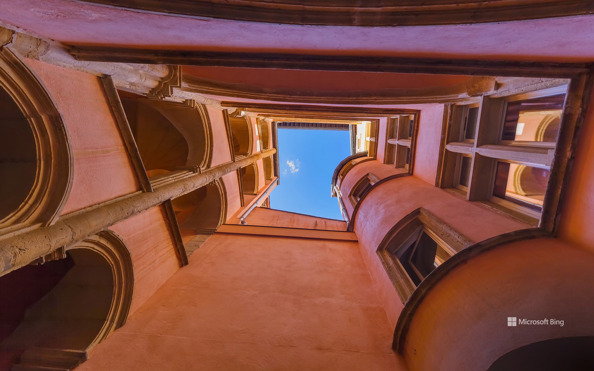
在法国里昂,你不只是简单地走过街巷,而是像在城市的脉络中轻盈滑行。这里的穿廊,是一条条隐秘的通道,蜿蜒穿梭于庭院与建筑之间,将简单的散步变成一场寻宝之旅。它们曾是最早的捷径,帮助居民避雨、搬运货物,或悄然穿过中世纪街区。如今,这些通道更多承载的是探索的乐趣。它们的历史可追溯至公元四世纪,在文艺复兴时期更显重要——当时丝绸商人利用这些通道,将珍贵织物从作坊安全运送到河边,免受风雨侵扰。二战期间,抵抗运动战士也曾借助这些通道作为秘密逃生路线。走进里昂,你会发现,每一条穿廊都藏着故事,每一次转角都可能遇见历史的回声。
A traboule in Lyon, France
In Lyon, France, you don't just walk through the city—you glide through it. The traboules, a network of hidden passageways threading between courtyards and buildings, turn a simple stroll into a treasure hunt. They were the original shortcuts, allowing residents to dodge rain, carry goods, or move discreetly through the medieval quarters. Today, they're less about practicality and more about discovery. These passages date back to the fourth century but became essential during the Renaissance, when silk traders used them to shuttle delicate fabrics safely from workshops to the river without braving the weather. Later, during World War II, Resistance fighters used the traboules as escape routes.
Most of Lyon's traboules are tucked away in the Vieux Lyon and Croix-Rousse districts. Push open what looks like an ordinary wooden door, and you might step into a courtyard with spiral staircases, arched galleries, and stone corridors that snake between buildings. Some passages are public, some private, and all of them blur the line between indoors and outdoors. Walking a traboule is like flipping through the city's footnotes. You're right in the heart of a living neighborhood, yet moving through centuries of history.
秋天的伊吕波坂,日光市,栃木县,日本 Irohazaka Road in fall, Nikko, Tochigi, Japan (© oneinchpunch/Shutterstock)

秋天的伊吕波坂,日光市,栃木县,日本 Irohazaka Road in fall, Nikko, Tochigi, Japan (© oneinchpunch/Shutterstock)
像日光那样“弯道飞驰” Bend it like Nikko
秋天的伊吕波坂,日光市,栃木县,日本
秋天是伊吕波坂最耀眼的季节,正如今日画面所示。从10月下旬到11月上旬,枫叶的红、银杏的金、落叶松的黄层层叠叠,铺满山坡。蜿蜒的道路一路通向日光的著名景点:攀登至顶,便可抵达赤地平原。这里有缆车可俯瞰中禅寺湖和气势磅礴的华严瀑布。山顶的中禅寺湖静谧如镜,与盘旋的山路形成鲜明对比,而瀑布在下方轰鸣奔泻。几个世纪前,朝圣者沿着这条路前往神社与寺院,如今旅行者依旧踏上同样的路径,只是相机快门声取代了虔诚的诵经声。
Irohazaka Road in fall, Nikko, Tochigi, Japan
If you think the alphabet is straightforward, Japan's Irohazaka Road in Nikko will twist that belief right out of you. Named after the old Japanese syllabary 'Iroha,' this mountain pass once had 48 hairpin bends—each curve matched to a character of the alphabet. Today, it's a pair of separate one-way roads—one goes up, the other comes down, and both make drivers feel as if they're spelling out a story with every turn.
Fall is when Irohazaka truly shows off, as captured in today's image. From late October to early November, maple reds, ginkgo golds, and larch yellows spill down the slopes. The winding route also leads to some of Nikko's greatest hits. Climb up, and you'll reach the Akechidaira Plateau. Here, a ropeway gives you sweeping views of Lake Chuzenji and the powerful Kegon Falls. At the top, Lake Chuzenji offers a calm contrast to the dizzying drive, while the waterfall roars below. Centuries ago, pilgrims took this same route to reach sacred shrines and temples. Today, travelers follow in their tracks, though probably with more camera clicks than chants.
夜晚的箭袋树与银河,基特曼斯胡普,纳米比亚 Quiver trees under the Milky Way, Keetmanshoop, Namibia (© Wim van den Heever/naturepl.com)
夜晚的箭袋树与银河,基特曼斯胡普,纳米比亚 Quiver trees under the Milky Way, Keetmanshoop, Namibia (© Wim van den Heever/naturepl.com)
星光下的颤动之树 Quivering under starlight
箭袋树,基特曼斯胡普,纳米比亚
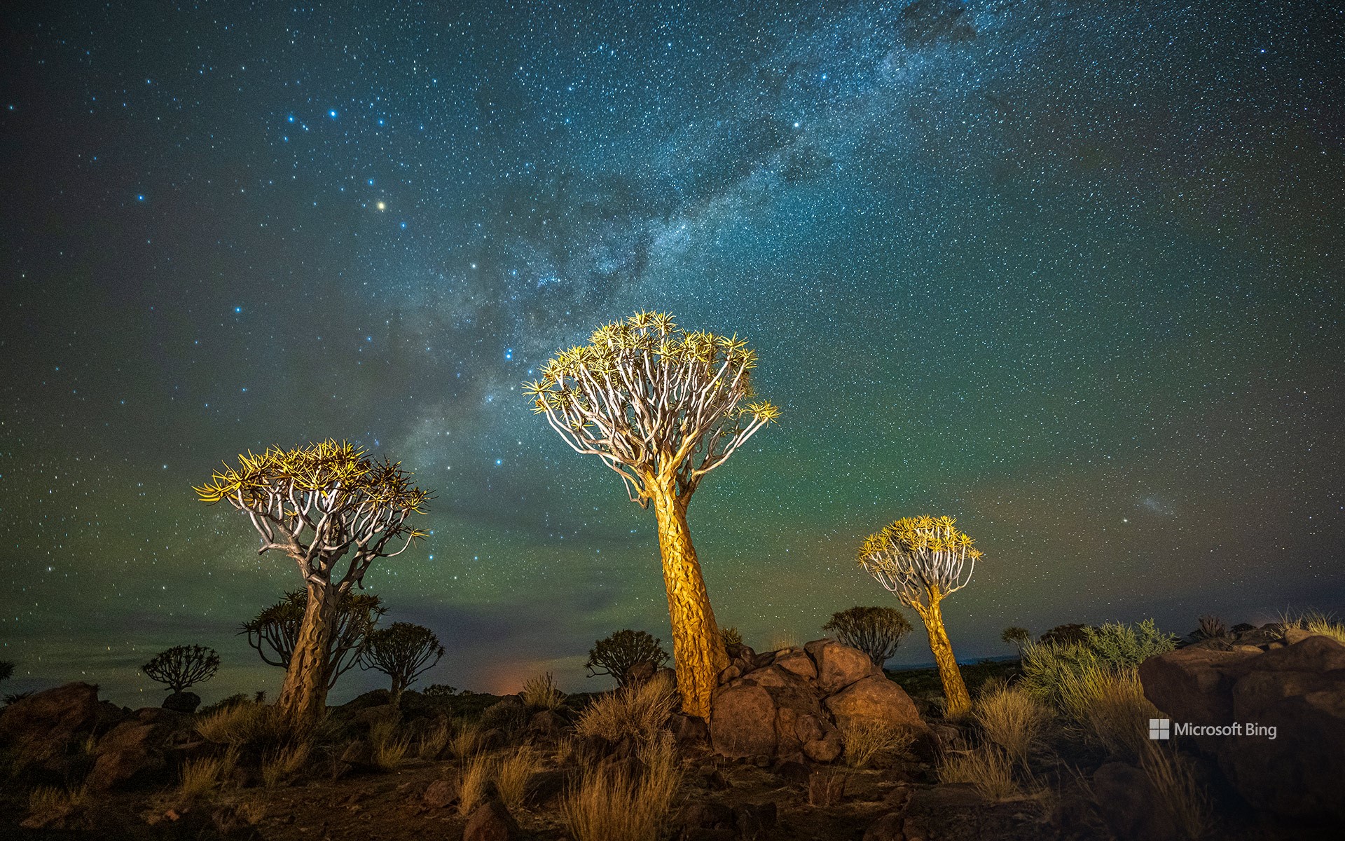
在地球上所有的植物中,箭袋树或许最像来自未来的生命。它们分布于非洲南部,尤其是纳米比亚的干旱地区。虽然名字里有“树”,但它其实是一种芦荟属植物,经过漫长岁月的适应,能在炙热的沙漠中顽强生存。厚实的树干储存水分,分枝则能反射热量,帮助它抵御极端环境。箭袋树可高达7米,有的寿命超过百年,是沙漠生态系统中不可或缺的一环。在几乎没有其他树木的荒原上,它为鸟类提供了珍贵的栖息与筑巢之所。
“箭袋”这一名称正源于当地桑人的古老习俗,他们曾将树枝挖空制作箭袋。位于基特曼斯胡普附近的箭袋树森林如今被列为纳米比亚国家纪念地,也是该国最受摄影师喜爱的景点之一。这片沙漠拥有地球上最清澈的夜空,是观星的绝佳之地。在今日图片中,箭袋树的轮廓映衬在银河之下,仿佛在星光中轻轻颤动。尽管气候变化正在改变它们的自然分布范围,这些树依然是纳米比亚粗犷之美的象征,提醒着我们,大自然总能以最富想象力的方式适应与延续。
Quiver trees, Keetmanshoop, Namibia
Of all the plants on Earth, the quiver tree looks the most like a vision from the future. Found in Southern Africa, including parts of Namibia, these striking giants are not true trees but a species of aloe adapted to life under the desert's scorching sun. Their thick trunks store water, while their branches reflect heat, helping them endure harsh conditions. Reaching up to 23 feet in height, with some living for more than 100 years, quiver trees are also vital to their ecosystem. They offer rare perches and nesting sites for birds in landscapes where few other trees exist.
The name 'quiver' comes from the Indigenous San people, who once hollowed out the branches to craft lightweight arrow holders, or quivers. The Quiver Tree Forest near Keetmanshoop is a national monument and one of Namibia's most photographed sites. With some of the clearest skies on Earth, the desert provides a perfect backdrop for stargazing. In today's image, quiver trees stand silhouetted against the Milky Way. Though climate shifts are altering their natural range, these trees remain a symbol of Namibia's rugged beauty—and a reminder of how nature adapts in the most imaginative ways.
斗兽场鸟瞰图,罗马,意大利 Aerial view of the Colosseum, Rome, Italy (© Nico De Pasquale Photography/Getty Images)

斗兽场鸟瞰图,罗马,意大利 Aerial view of the Colosseum, Rome, Italy (© Nico De Pasquale Photography/Getty Images)
条条大路通罗马 All roads lead to Rome
斗兽场,罗马,意大利
觉得现代体育赛事已经足够精彩了吗?在古罗马时代,观众们坐在斗兽场中目睹的表演要激烈得多。这座宏伟的圆形露天竞技场由罗马皇帝韦斯帕先于公元72年下令建造,其子提图斯于公元80年完工。与早期依山而建、借助地形支撑的剧场不同,罗马斗兽场完全独立矗立,是一座自成体系的建筑奇迹。斗兽场由石块与混凝土建成,拱门与穹顶结构支撑着可容纳多达5万名观众的竞技场。角斗士的搏斗、异国野兽的展示,甚至模拟海战,都令观众热血沸腾地下的升降机与暗门让场景转换瞬息万变,充满戏剧张力。
进入中世纪后,斗兽场被赋予了新的用途:曾一度被改作教堂,后来又成为堡垒。几个世纪以来,它经受了雷击、地震与污染的破坏。建筑中大量的石灰华与大理石被重新利用,修建宫殿、防御工事,甚至教堂。这种做法被称为“拆卸再利用”, 它让斗兽场的碎片真正融入了罗马这座不断演变的城市。直到19世纪,人们才开始对其进行系统的保护。如今,罗马斗兽场作为受保护的世界文化遗产,每年吸引近 700 万名游客,依然是意大利最具象征意义的地标之一,见证着古罗马的荣耀与永恒。
Colosseum, Rome, Italy
Think modern sports are dramatic? Ancient Romans had front-row seats to spectacles far more intense inside the Colosseum. Commissioned by the Flavian emperor Vespasian in 72 CE and finished by his son Titus in 80 CE, this amphitheater broke tradition with its predecessors that were built into hillsides for natural support. Instead, the Colosseum was a fully free-standing architectural giant. Crafted from stone and concrete, its arches and vaults supported an arena that could host up to 50,000 spectators. Gladiators, exotic animals, and even staged sea battles thrilled the crowds, while hidden elevators and trapdoors created sudden, dramatic appearances.
During the Middle Ages, the Colosseum found new purposes: first as a church, later as a fortress. Over the centuries, it endured damage from lightning strikes, earthquakes, and pollution. Much of its marble and travertine was also reused in palaces, fortifications, and even churches—a practice known as 'spolia,' which quite literally wove pieces of the structure into the evolving city of Rome. It wasn't until the 19th century that serious preservation began. Today, recognized as a protected monument and welcoming nearly 7 million visitors annually, the Colosseum remains one of Italy's most iconic landmarks.
条顿堡森林的伊克斯坦岩石层,德国 The Externsteine rock formation in the Teutoburg Forest, Germany (© Michael Sroka/Getty Images)
条顿堡森林的伊克斯坦岩石层,德国 The Externsteine rock formation in the Teutoburg Forest, Germany (© Michael Sroka/Getty Images)
传奇之地 Where legends rise
条顿堡森林的伊克斯坦岩石层,德国
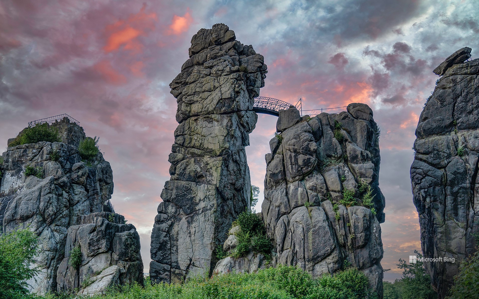
在德国北莱茵-威斯特法伦州的霍恩-巴特迈因贝格附近,条顿堡森林的腹地矗立着壮丽的埃克斯特恩岩石群。这些砂岩石柱形成于约7,000万年前,是德国最重要的自然与文化地标之一。高达35米的岩柱以其独特的形态与深厚的历史底蕴吸引着无数游客。早在中世纪,这里就被用作宗教祭祀之地,这一点从12世纪刻在岩石上的下十字架像浮雕中可见一斑,这是阿尔卑斯山以北最古老的此类浮雕。
如今,游客可以沿着石阶与步道攀登至岩石顶端,在那里俯瞰条顿堡森林的壮丽全景。无论被视为充满神秘能量的圣地、令人叹为观止的纪念碑,还是条顿堡森林与埃格山自然公园中一个多样的景点,埃克斯特恩岩石群都能为游客带来难忘的体验。这里设有标识清晰的登山路线、信息中心,以及诸如自然体验中心和鸟类公园等周边景点。无论春夏秋冬,埃克斯特恩岩石群都以独特的姿态诉说着岁月的传奇,成为一处真正跨越时间的奇景。
礁湖星云中的星际云,由哈勃太空望远镜拍摄 Interstellar clouds in the Lagoon Nebula, captured by the Hubble Space Telescope (© ESA/NASA)

礁湖星云中的星际云,由哈勃太空望远镜拍摄 Interstellar clouds in the Lagoon Nebula, captured by the Hubble Space Telescope (© ESA/NASA)
从前有一颗星星 Once upon a star
礁湖星云
宇宙生机勃勃,生生不息。图中的礁湖星云中,一个名为NGC 6530的星团正在孕育新生恒星,这光芒提醒着我们,宇宙的起源早已交织其中。它距离我们约4350光年,已有数百万年历史,目前仍处于恒星形成的早期阶段。
礁湖星云,在梅西耶星表中名列第八,简称M8,是一个位于南天人马座的发射星云(也可称之为电离氢区)。在NGC用表中排名6523,又称NGC 6523。这个星云是许多天文爱好者十分熟悉并且喜爱的天体之一,也是天文摄影的热门目标天体。礁湖星云充满炽热气体,是许多年轻恒星的家园,因其中心左侧的数道尘埃带而获得了礁湖星云的别名。
Carl Sagan Day
The universe hums with creation. Featured here, in the Lagoon Nebula, a cluster called NGC 6530 is kindling newborn stars, a glowing reminder that beginnings are woven into the fabric of the cosmos. About 4,350 light-years away and a few million years old, it is a stellar formation still in its earliest chapter.
The world celebrates Carl Sagan Day every November 9 to honor the astronomer who shared distant wonders through stories people could understand. Founded in 2009, the day is observed worldwide, marked by lectures, planetarium shows, and stargazing nights that carry Sagan's call for scientific curiosity.
Carl Sagan's legacy stretches from NASA's Voyager missions and the Golden Record to his Cosmos television series, inspiring millions to see science as both reason and a source of endless possibilities. At Cornell University, home to the Carl Sagan Institute, his vision continues through the search for habitable worlds and the celebration of cosmic discovery. In the night sky, NGC 6530 offers a fitting tribute: a nursery of suns forming within clouds of gas and dust, echoing Sagan's reminder that 'We are made of star stuff.'
班登海滩的海蚀柱,俄勒冈州,美国 Sea stacks of Bandon Beach in Bandon, Oregon (© Grant Ordelheide/TANDEM Stills + Motion)

班登海滩的海蚀柱,俄勒冈州,美国 Sea stacks of Bandon Beach in Bandon, Oregon (© Grant Ordelheide/TANDEM Stills + Motion)
班登的明星岩石 Rock stars of Bandon
俄勒冈州的班登海滩
驶出101号公路,俄勒冈州的班登便迎来了来访者,这里弥漫着咸咸的空气和轻柔的港口钟声。这座小镇始建于19世纪50年代,最初只是个小聚居地,后来发展成为木材和鲑鱼捕捞中心。蔓越莓成为当地的主要作物,至今仍是每年九月蔓越莓节的庆祝活动。老城区的木板路咖啡馆和画廊反映了那段历史,而科基尔河灯塔则矗立在布拉兹海滩,经过修复,依然屹立在那里,提醒着人们当年它曾指引船只的航向。
从灯塔步行一小段路即可到达海滩,那里展现着令人回味的海岸景观:班登的海蚀柱,正如今天图片中所展现的那样。这些地貌经过数千年的海浪、风蚀和缓慢崩塌的侵蚀,讲述着一段地质故事。面岩(Face Rock)形似当地传说中少女翘起的下巴。附近的巫师帽(Wizard's Hat)像一顶尖顶的帽子,直冲云霄;大象岩(Elephant Rock)拱起,如同一条伸向潮水的象鼻。其他值得注意的景观包括贝壳角(Coquille Point)、桌岩(Table Rock)以及猫和小猫(Cat and Kittens)海蚀柱。作为俄勒冈群岛国家野生动物保护区的一部分,这些海蚀柱为海鸟提供了庇护,并展现了海洋和时间的坚韧力量。
Bandon Beach in Bandon, Oregon
Pull off of Highway 101, and Bandon, Oregon, greets you with salty air and the clang of harbor bells. The town began as a small settlement in the 1850s and grew into a center for timber and salmon fishing. Cranberries became a key crop and are still celebrated each September during the Cranberry Festival. Old Town reflects that past with boardwalk cafés and galleries, while the Coquille River Lighthouse stands restored at Bullards Beach as a reminder of the days when its beacon guided ships.
A short walk from the lighthouse leads to the beach where an evocative coastal landscape unfolds: Bandon's sea stacks, featured in today's image. Sculpted over millennia by waves, wind, and the slow collapse of arches, these formations tell a geologic story. Face Rock resembles the tilted chin of a maiden from local legend. Nearby, Wizard's Hat rises like a pointed cap against the sky, and Elephant Rock arches like a trunk reaching for the tide. Other notable shapes include Coquille Point, Table Rock, and the Cat and Kittens stacks. Protected as part of the Oregon Islands National Wildlife Refuge, these stones shelter seabirds and reveal the patient force of ocean and time.
哈里朋柴佛塔寺的彩色灯笼, 南奔府, 泰国 Colorful lanterns at the temple of Wat Phra That Hariphunchai, Lamphun, Thailand (© MR. ANUJAK JAIMOOK/Getty Images)

哈里朋柴佛塔寺的彩色灯笼, 南奔府, 泰国 Colorful lanterns at the temple of Wat Phra That Hariphunchai, Lamphun, Thailand (© MR. ANUJAK JAIMOOK/Getty Images)
满天心愿 Sky full of wishes
庆祝义蓬节
如果一盏天灯能承载你的心愿,你会许下什么?今晚,在泰国北部,义蓬节为你带来这样的机会。这个延续数百年的兰纳传统,在农历十二月举行,人们点亮孔明灯以纪念佛陀。相传每一盏灯都能带走厄运,照亮通往美好未来的道路。孩子们扶稳灯架,长者低声祈福,成百上千的灯火缓缓升起,越过树梢,点亮夜空。同一轮满月下,南方的水灯节也在进行,烛光点点的花船在水面缓缓漂流。
在泰国北部的南奔府,有一座历史悠久的寺庙——哈里朋柴佛塔寺,它是欣赏义蓬节灯会的热门地点。寺庙的历史可以追溯到公元897年,当时哈里朋柴国王建造这座佛塔,用来供奉佛陀的一缕头发。佛塔至今仍矗立在寺院中央,周围的建筑则在后来的几个世纪逐渐完善,形成了如今的格局。寺庙的殿堂里,精美的木雕工艺展示了代代匠人的技艺。每年义蓬节期间,成千上万盏孔明灯缓缓升空,古老的祈愿与现代的祝福在夜空交织,让人仿佛穿越千年,感受文化与信仰的延续。
佩尼亚罗亚山毛榉森林, 蒙卡约自然公园, 萨拉戈萨, 阿拉贡, 西班牙 Peña Roya beech forest, Moncayo Natural Park, Zaragoza, Aragon, Spain (© David Santiago Garcia/DEEPOL by plainpicture)
佩尼亚罗亚山毛榉森林, 蒙卡约自然公园, 萨拉戈萨, 阿拉贡, 西班牙 Peña Roya beech forest, Moncayo Natural Park, Zaragoza, Aragon, Spain (© David Santiago Garcia/DEEPOL by plainpicture)
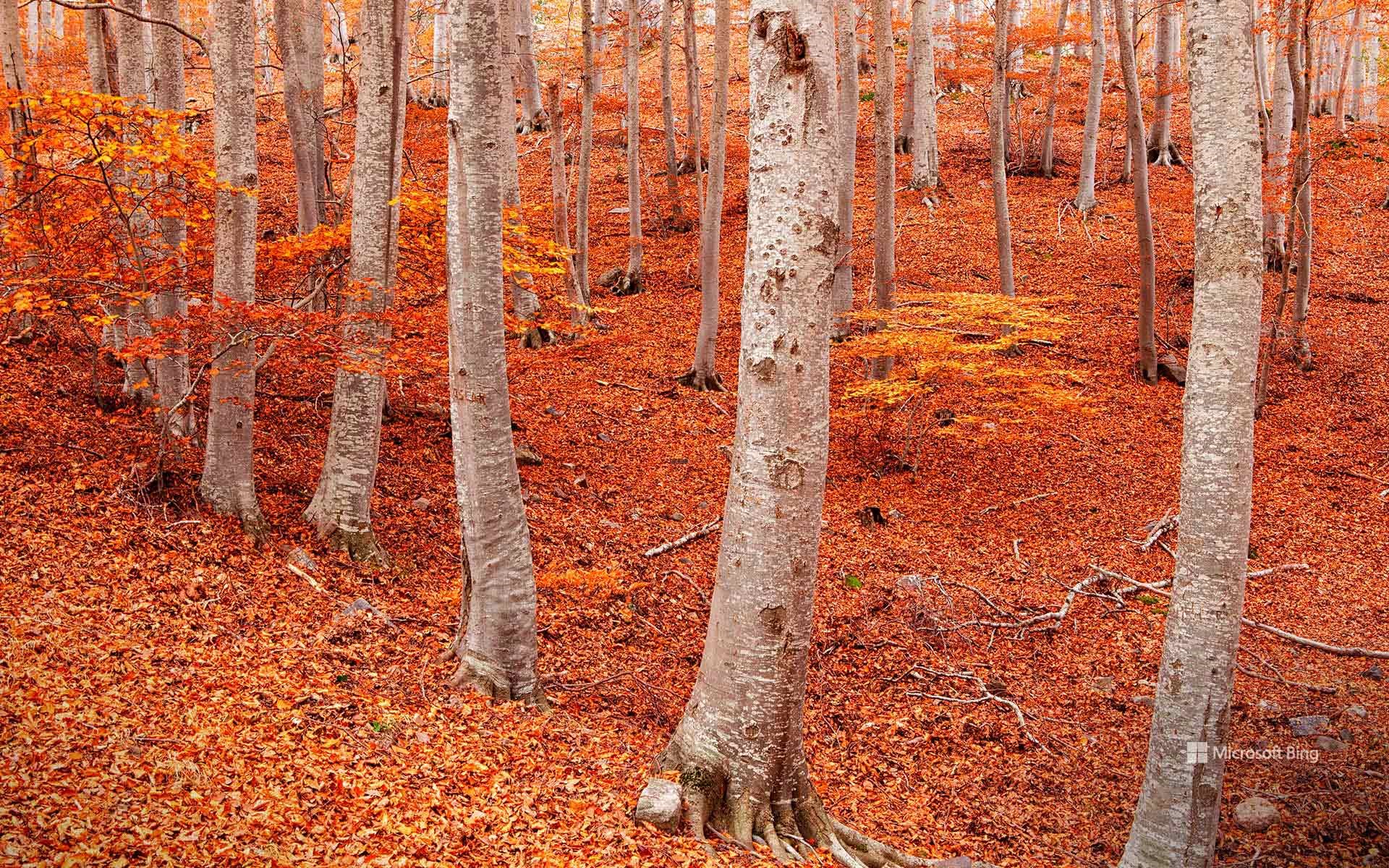
秋天来了,你开心吗? Orange you glad it's fall?
佩尼亚罗亚山毛榉森林,西班牙
西班牙的阿拉贡地区,一般让人想到的是阳光和灌木,而不是森林的阴凉与静谧。然而,当你沿着蒙卡约山坡向上攀登,故事会出现意想不到的转折:一片浓密、低语的山毛榉林悄然迎面而来。这座山犹如气候过山车:山脚是地中海灌木,半山腰是橡树和松林,再往上,霎时间你便置身佩尼亚罗亚,这片山毛榉仙境仿佛在宣告:"由我来演绎秋天吧!"
秋天,是它们最耀眼的季节。森林像一床拼接的彩色被子,铺满红、金、橙的斑斓。徒步者踩着落叶,发出欢快的“咔嚓”声;鹿儿在林间轻盈穿行,野猪在灌木丛中拱食,苍鹰、金雕等猛禽的鸣叫,为这片山林配上了背景乐。正当你以为这里只有树木时,蒙卡约却展现出人文风情:山腰间隐匿着修道院,岩壁上依偎着小小的隐修所,还有那些曾把森林当作粮仓的古老村落。如今,人们来这里,不再是为了木材,而是为了徒步、拍照,和那一口甘甜的山间空气。
Peña Roya beech forest, Moncayo Natural Park, Aragon, Spain
Spain's Aragon region isn't exactly famous for its forests—it's more 'sun and scrub' than 'shade and shuffle.' And yet, climb the slopes of Moncayo and you'll walk straight into a twist ending: a dense, whispering beech forest. The mountain is a climate roller coaster. At the bottom? Mediterranean shrubs. Midway up? Oaks and pines. Push further? Suddenly you're in Peña Roya, a beech wonderland that seems to say, 'Surprise, leaf it to me!'
Fall is their show-off season. The forest becomes a patchwork quilt of red, gold, and orange, while hikers crunch happily through the leaves. Deer tiptoe through the trees, wild boar snuffle in the undergrowth, and birds like Eurasian goshawks and golden eagles supply the soundtrack. And just when you think it's all about trees, Moncayo reminds you of its human side: monasteries tucked into the mountainside, hermitages clinging to rocks, and villages that once treated the forest as their pantry. Today, people come not for timber, but for trails, photos, and that sweet mountain air.