标签 岛 下的文章
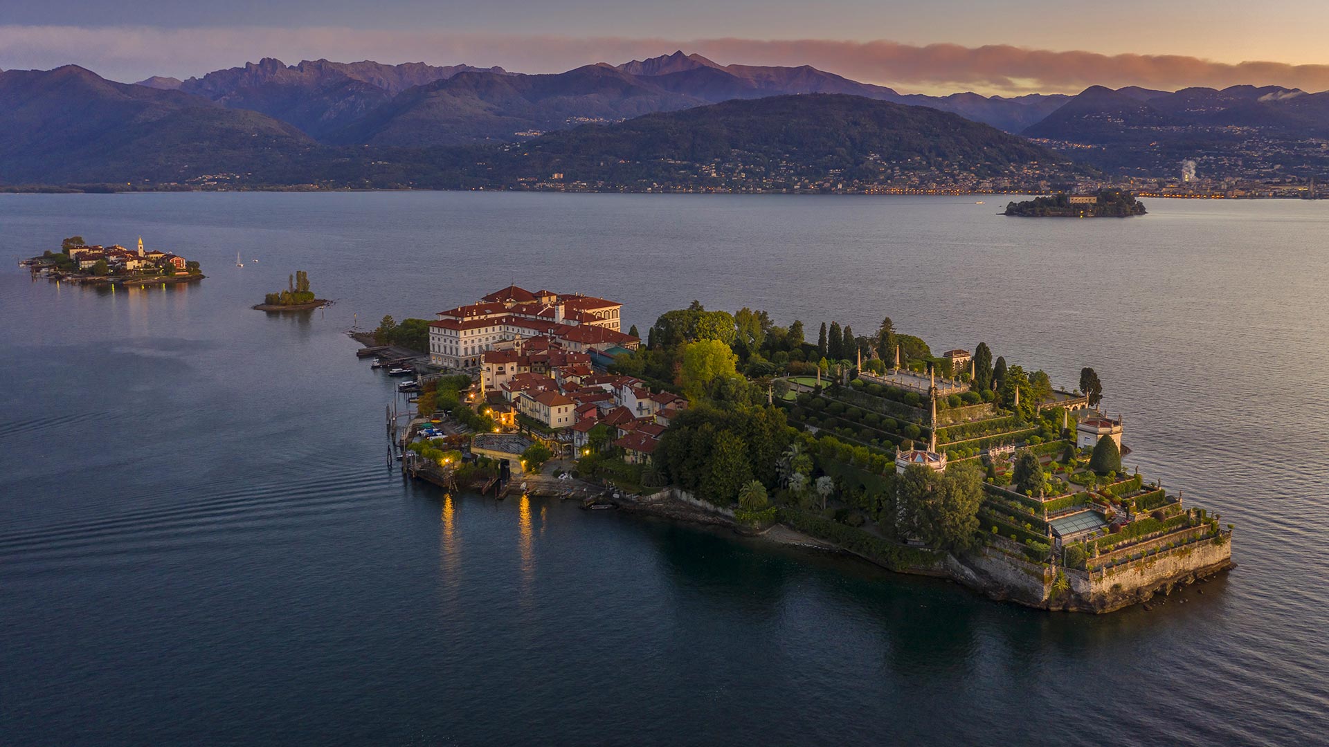
伊索拉贝拉岛,意大利马焦雷湖 (© Massimo Ripani/eStock)
圣埃尔姆附近的潘塔留岛鸟瞰图,西班牙马略卡岛 Aerial view of the island Pantaleu near Sant Elm, Mallorca, Spain (© Dimitri Weber/Azing航空公司)
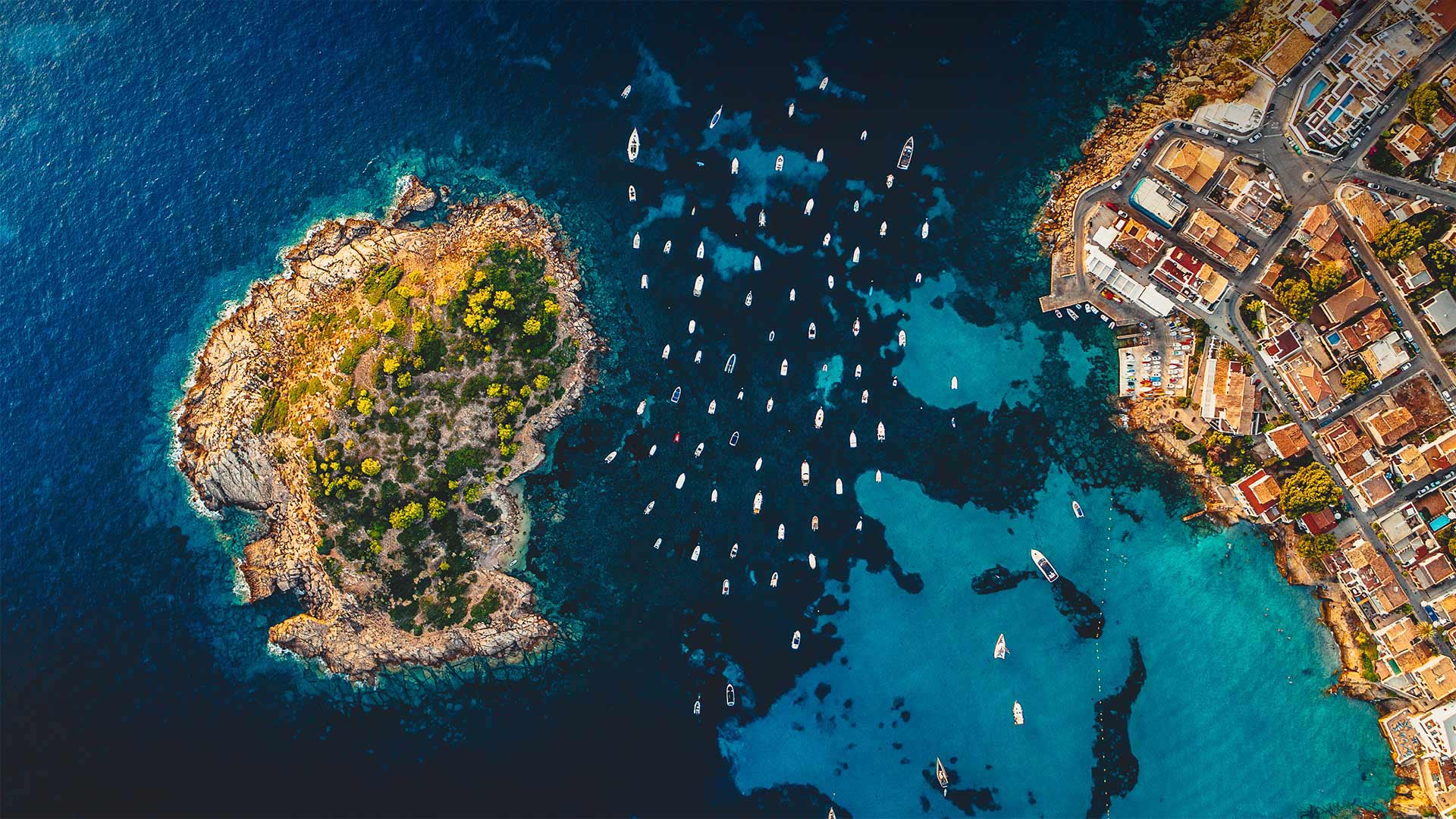
圣埃尔姆附近的潘塔留岛鸟瞰图,西班牙马略卡岛 Aerial view of the island Pantaleu near Sant Elm, Mallorca, Spain (© Dimitri Weber/Azing航空公司)
汪洋中的小岛 Little Island, Big Sea
Pantaleu
There isn't much to the tiny island of El Pantaleu (or Es Pantaleu in Catalan), cast off the westernmost shore of Mallorca, itself a relatively small island only 30-40 miles across. Pantaleu and Mallorca are part of the archipelago of Balearic Islands in the Balearic Sea, off the east coast of Spain. Mallorca, Ibiza, Menorca, and Formentera are the chain's four major islands and are famous as tourist destinations popular among those seeking the warm Mediterranean climate and inviting shoreline.
Pantaleu is more precisely an islet, a mere rock of about six acres in size. Its highest point is 80 feet. Not much grows on El Pantaleu, and no one lives on it. Mallorca is only about 1,000 feet away, making it a vigorous but doable swim for the many who have tried from the beach at the village of Sant Elm. Technically, no one is allowed to step foot onto Pantaleu, because it is designated a nature reserve along with the much larger Dragonera Island a few miles farther to the west.
Pantaleu is most useful as a wind break for boats, as you can see from this aerial photo. The notch between the islet and the main island is a popular anchorage for the many pleasure boats that cruise these waters. Even centuries ago, sailors understood the value of Pantaleu as an anchorage. In 1229, young James I the Conqueror, King of Aragon, and his fleet sought refuge from a storm behind Pantaleu before he embarked on his campaign to invade the Balearic Islands and start making good on his nickname. These days, most of the turf battles around here have been settled, although you might have to parry a vacationer for a spot on the sand or a table at happy hour.
潘塔留
位于马略卡岛最西岸的小岛El Pantaleu(或加泰罗尼亚的Es Pantaleau)没有什么特别之处,它本身是一个直径只有30-40英里的相对较小的岛屿。Pantaleu和Mallorca是西班牙东海岸巴利阿里海巴利阿里群岛的一部分。马洛卡岛、伊维萨岛、梅诺卡岛和福门特拉岛是该群岛的四个主要岛屿,是著名的旅游目的地,深受寻求温暖地中海气候和迷人海岸线的游客的欢迎。
潘塔留更准确地说是一个小岛,一块只有六英亩大小的岩石。它的最高点是80英尺。El Pantaleu岛上没有多少植物,也没有人靠它生活。马略卡岛离这里只有1000英尺远,对于许多在圣埃尔姆村海滩上尝试游泳的人来说,这是一次充满活力但可行的游泳。从技术上讲,任何人都不允许踏上潘塔留岛,因为它被指定为自然保护区,与西边几英里远的大得多的龙时代岛一起。
从这张航拍照片中可以看出,Pantaleu是船只避风的最佳场所。小岛和主岛之间的缺口是许多游船在这些水域航行的热门锚地。甚至在几个世纪前,水手们就知道潘塔留作为锚地的价值。1229年,年轻的征服者、阿拉贡国王詹姆斯一世和他的舰队在开始入侵巴利阿里群岛并开始利用他的绰号之前,在潘塔留后面躲避风暴。这些天来,这里的大部分地盘之争都已经解决了,尽管你可能不得不避开度假者在沙滩上或欢乐时光的餐桌上。
基姆湖上的淑女岛,德国巴伐利亚州 Aerial view of Fraueninsel island in Chiemsee, Bavaria, Germany (© Malorny/Getty Images)

基姆湖上的淑女岛,德国巴伐利亚州 Aerial view of Fraueninsel island in Chiemsee, Bavaria, Germany (© Malorny/Getty Images)
“巴伐利亚海”中的岛屿 Island in the "Bavarian Sea"
Fraueninsel, Chiemsee, Bayern
Just 15.5 hectares in size, the Fraueninsel is still the second-largest island in the Chiemsee after the Herreninsel - admittedly, there are only three inland islands in total, and the tiny Krautinsel as the third in the group is also uninhabited. The car-free Fraueninsel, whose appearance is mainly characterized by the Benedictine monastery of Frauenchiemsee (also known as Frauenwörth), founded in 782, can be reached all year round with the passenger ships of the Chiemsee shipping company.
The only settlement on the Fraueninsel is called Frauenchiemsee. It consists of about 50 houses in which around 250 people live. The name of the place and the island are often used synonymously. Chiemsee, which covers almost 80 square kilometers, is Bavaria's largest lake and Germany's third-largest after Lake Constance and Müritz. In the absence of its own seashore, an affectionate nickname for Lake Chiemsee has emerged among the Bavarian population over time: it is very often referred to as the "Bavarian Sea".
Fraueninsel、切姆西、拜仁
面积只有15.5公顷的弗劳尼塞尔岛仍然是基姆塞岛上仅次于赫雷宁塞尔岛的第二大岛屿——不可否认,总共只有三个内陆岛屿,而作为该群岛第三大岛屿的小克劳蒂塞尔岛也无人居住。无车Fraueninsel的外观主要以建于782年的Frauenchiemsee(也称为Frauenwörth)本笃会修道院为特征,可以通过Chiemsee航运公司的客船全年到达。
关于Fraueninsel的唯一解决方案称为Frauenchiemsee。它由大约50座房屋组成,其中约有250人居住。这个地方和这个岛的名字通常是同义词。基姆塞湖占地近80平方公里,是巴伐利亚州最大的湖泊,也是德国仅次于康斯坦斯湖和缪里兹湖的第三大湖。由于没有自己的海岸,随着时间的推移,基姆塞湖在巴伐利亚人中出现了一个亲切的昵称:它通常被称为“巴伐利亚海”。
布满奇石的青海岛,日本北长门海岸国定公园 Omijima Island in Kita-Nagato Kaigan Quasi-National Park, Japan (© Sean Pavone Photo/Adobe Stock)
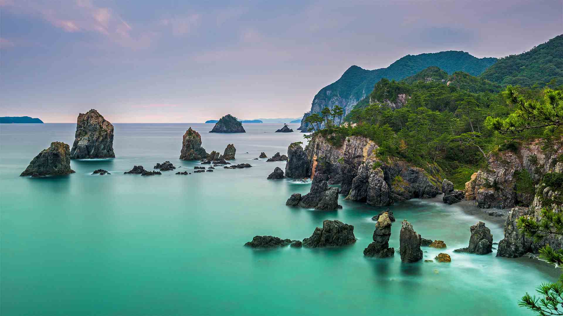
布满奇石的青海岛,日本北长门海岸国定公园 Omijima Island in Kita-Nagato Kaigan Quasi-National Park, Japan (© Sean Pavone Photo/Adobe Stock)
海上阿尔卑斯山 Alps of the sea
Marine Day in Japan
The striking coastline of Omijima Island has earned it the nickname 'The Alps of the Sea.' Its sheer cliffs and dramatic angles certainly echo the skyscraping peaks in that European mountain range. But a visit to Omijimi Island will take you to the other side of the world, to Kita-Nagato Kaigan Quasi-National Park, in Yamaguchi, Japan. Year-round scuba diving adventures reveal a world under the waves just as beautiful as the one above the surface.
日本的海洋日
大尾岛引人注目的海岸线为它赢得了“海洋阿尔卑斯山”的绰号它陡峭的悬崖和引人注目的角度肯定与欧洲那条山脉上的群峰相呼应。但是,游览大米岛将把你带到世界的另一边,日本山口的北长门凯根准国家公园。一年到头的水肺潜水冒险揭示了波浪下的世界和水面上的世界一样美丽。
被翡翠湾环绕的芬尼特岛,太浩湖,加利福尼亚 Fannette Island surrounded by Emerald Bay, Lake Tahoe, California (© Rachid Dahnoun/Tandem Stills + Motion)
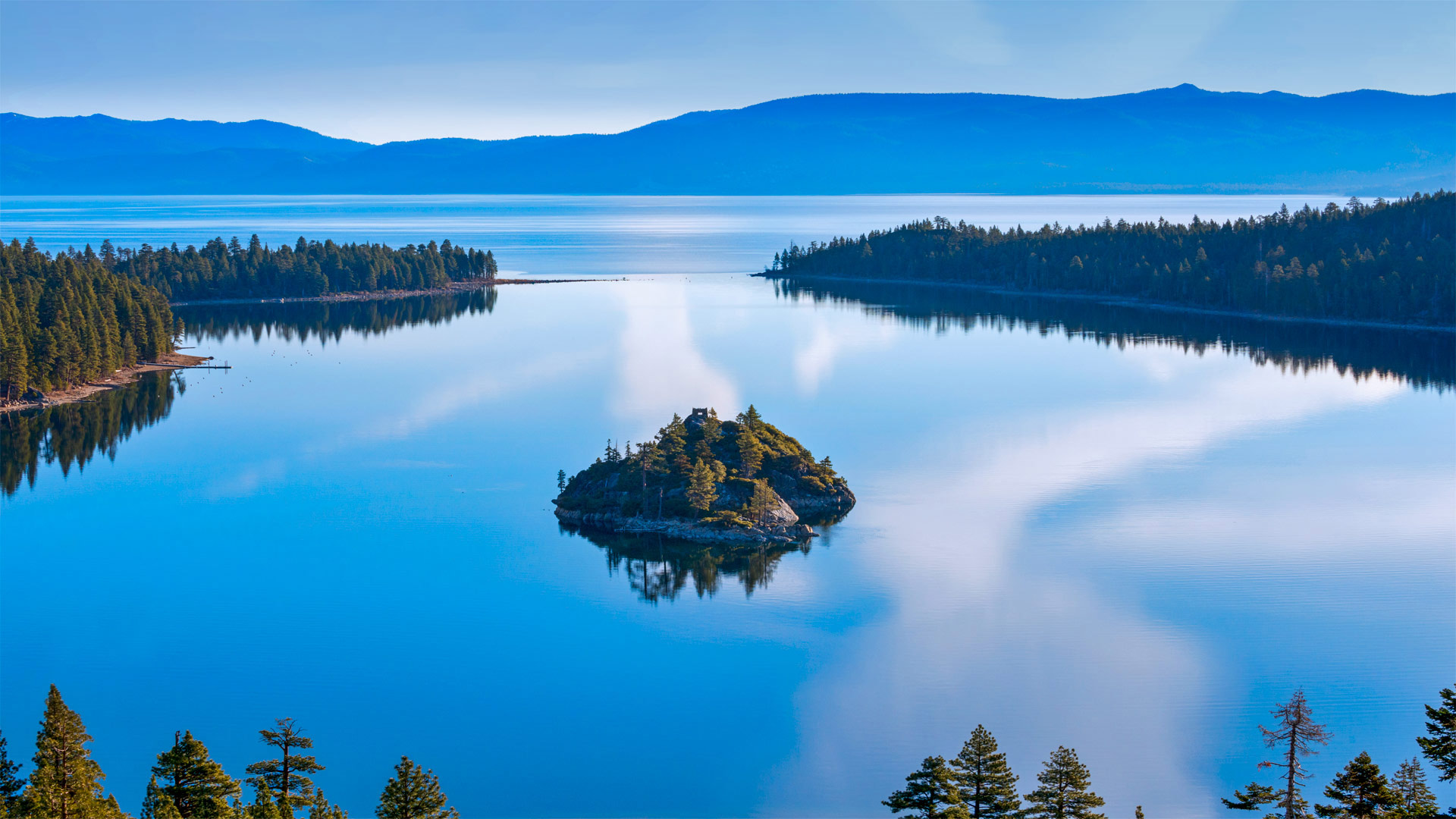
被翡翠湾环绕的芬尼特岛,太浩湖,加利福尼亚 Fannette Island surrounded by Emerald Bay, Lake Tahoe, California (© Rachid Dahnoun/Tandem Stills + Motion)
这座岛海拔超过一英里 This island is more than a mile high
Fannette Island, Lake Tahoe
Tucked into a tiny bay of a grand alpine lake is this granite bump called Fannette Island, the only island in Lake Tahoe. The massive lake lies in the Sierra Nevada at an altitude of 6,225 feet, straddling the state line between California to the west and Nevada to the east with near perfect symmetry. Fannette Island is in Emerald Bay, on the California side of Tahoe's southwest shore. A narrow inlet, seen here at the top center of this image, connects Emerald Bay to the rest of the lake, whose natural beauty draws visitors in all seasons of the year.
Lake Tahoe is known as a mecca for boaters and skiers. Its frigid alpine water is renowned for its clarity. Despite the cold winter temperatures that provide the surrounding ski resorts with ample snowpack, the lake never freezes. The largest alpine lake in North America, Tahoe rivals even the Great Lakes by volume because it is so deep.
Ice-Age glaciers, nature's master sculptors, carved out Emerald Bay eons ago, and for some reason left behind in its wake tiny Fannette Island. It has been known by a half dozen names over the last century, before Fannette finally stuck. A short hike to the top, 150 feet above the water, will take you to the ruins of an old stone building called the 'Tea House,' constructed in the 1920s by the former owner of the island as well as a nearby estate on Emerald Bay called Vikingsholm (the property is now owned by the state and is a popular feature of Emerald Bay State Park). The tea house was used for exactly that, intimate tea parties in surroundings that would be nearly impossible to duplicate in any other home. While tea is no longer served atop the island, the alpine vistas are still there for the taking.
芬尼特岛,太浩湖
在一个巨大的阿尔卑斯湖的一个小海湾里,有一个花岗岩突起,叫做范内特岛,它是太浩湖中唯一的一个岛。这个巨大的湖泊位于内华达山脉,海拔6225英尺,西跨加利福尼亚州,东临内华达州,几乎对称。范内特岛位于翡翠湾,在太浩岛西南海岸的加利福尼亚一侧。图中顶部中央有一个狭窄的小湾,将翡翠湾与湖的其余部分连接起来,湖的自然美景吸引了一年四季的游客。
太浩湖是著名的划船者和滑雪者的圣地。它寒冷的高山水以清澈见长。尽管寒冷的冬季为周围的滑雪场提供了充足的积雪,但湖面从未结冰。塔霍湖是北美最大的阿尔卑斯湖,其湖水如此之深,在容量上甚至可以与五大湖匹敌。
冰河时代的冰川,大自然的大师级雕塑家,在亿万年前就雕刻出了翡翠湾,出于某种原因,留下了小小的范内特岛。在范内特最终坚持之前,在过去的一个世纪里,人们已经知道了半打名字。登上海拔150英尺的山顶,你将看到一座名为“茶馆”的古老石头建筑的废墟,这座建筑是20世纪20年代由该岛的前主人建造的,附近还有一处位于翡翠湾的庄园,名为Vikingsholm(该庄园现在归国家所有,是翡翠湾国家公园的一个热门景点)。茶馆正是用来举办这种亲密的茶话会的,周围的环境几乎不可能在任何其他家庭中复制。虽然岛上不再供应茶,但阿尔卑斯山的景色仍然可以欣赏。
鸟瞰视角下的布雷阿岛,法国阿摩尔滨海省 Aerial view of Bréhat island, Côtes-d'Armor, France (© LECLERCQ Olivier/hemis.fr/Alamy)
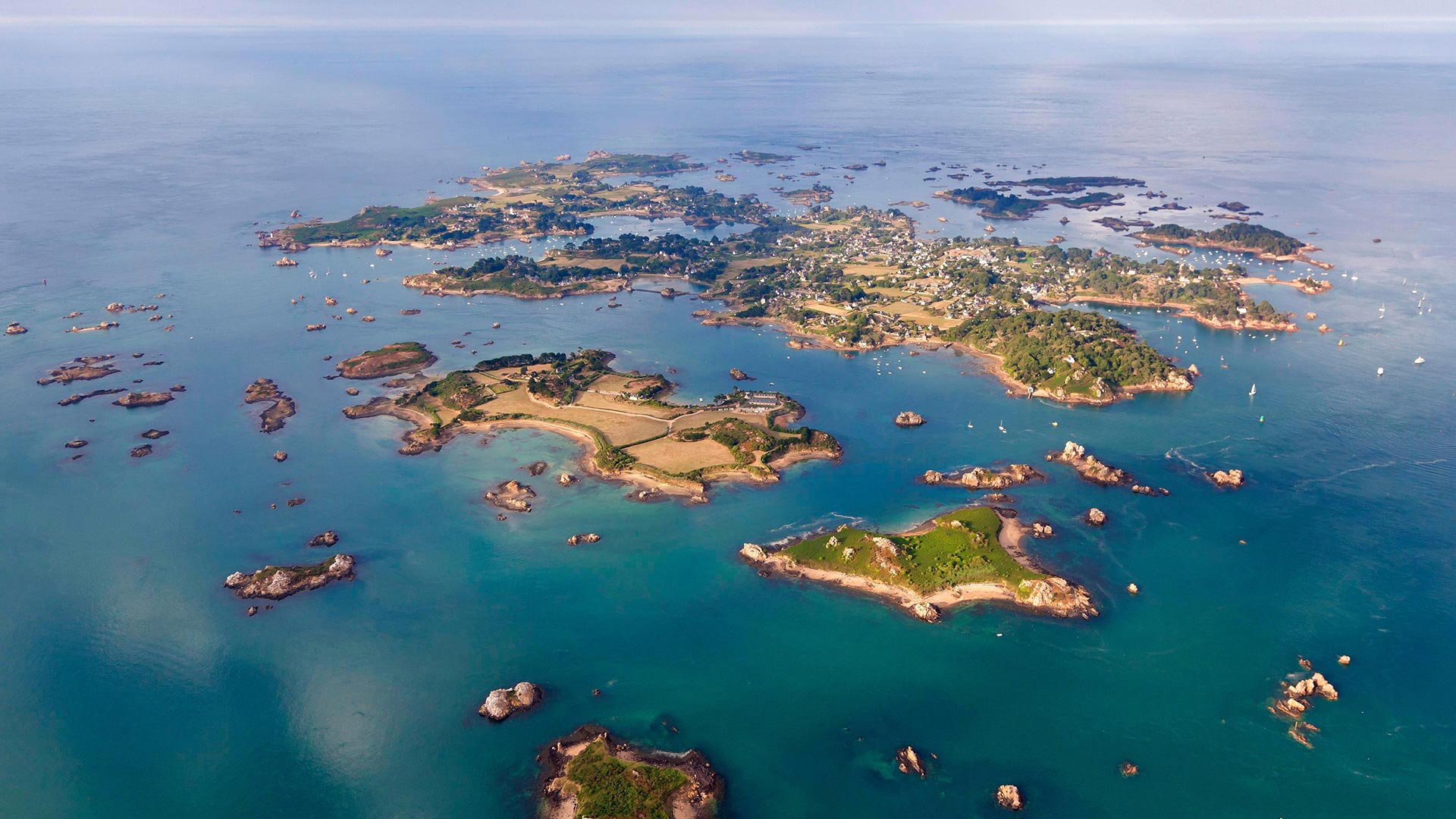
鸟瞰视角下的布雷阿岛,法国阿摩尔滨海省 Aerial view of Bréhat island, Côtes-d'Armor, France (© LECLERCQ Olivier/hemis.fr/Alamy)
布列塔尼!Brittany!
Bréhat island
Brittany wins us over! Today head to the Bréhat archipelago, made up of the main island and 86 neighboring islets and reefs. On July 13, 1907, Bréhat became the first natural site classified in France! 3.5 kilometers long and 1.5 kilometers wide, the island is accessible by boat and can be visited on foot or by bicycle. You will discover here a multitude of coves, beaches, and shelters for lost sailors. If you are planning a trip to the island, then we suggest you go in spring or autumn: there are fewer people, the weather remains mild and nature is lush.
All year round, the archipelago benefits from the influence of the Gulf Stream, which provides it with a particularly mild microclimate in winter. Many varieties of flowers color the island: exotic plants such as agave or echium; flowers like the hydrangea, the mimosa, the mulberry, the eucalyptus, the aloe, or the camellia… But the flower that most symbolizes Bréhat is the agapanthus which blooms from April to September and colors the paths with its hue blue-purple.
Traveling through Bréhat, you discover a rich and varied heritage that traces the maritime and military history that marked the island. In the past, Bréhat provided the crown of France with numerous corsairs that caused terror to reign over the Atlantic. Thus, there are monuments such as the Pont ar Prad built by Vauban, It was built to connect the two islands forming Bréhat and a citadel which today houses the Verreries de Bréhat.
布莱哈特岛
布列塔尼赢了我们!今天,前往布莱哈特群岛,该群岛由主岛和86个相邻的岛屿和珊瑚礁组成。1907年7月13日,布莱哈特成为法国第一个自然遗址!该岛长3.5公里,宽1.5公里,可乘船前往,可步行或骑自行车前往。你会在这里发现许多海湾、海滩和迷路水手的庇护所。如果你计划去这个岛旅行,那么我们建议你在春天或秋天去:那里的人少了,天气依然温和,自然繁茂。
该群岛全年都受益于墨西哥湾流的影响,这为它提供了一个特别温和的冬季小气候。岛上有许多不同种类的花:奇异的植物,如龙舌兰或刺五加;绣球花、含羞草、桑树、桉树、芦荟或茶花……但最能象征百日咳的花是阿伽潘托斯,它从4月到9月开花,并以蓝紫色将道路染成蓝色。
穿过布雷哈特,你会发现一个丰富多样的遗产,可以追溯该岛的海洋和军事历史。在过去,布莱哈特为法国王冠提供了无数海盗船,这些海盗船在大西洋上空制造了恐怖。因此,这里有一些纪念碑,比如沃班建造的阿尔普拉德桥,它是为了连接两个岛屿而建造的,形成了布雷哈特岛和一座城堡,今天这里有布雷哈特城堡。
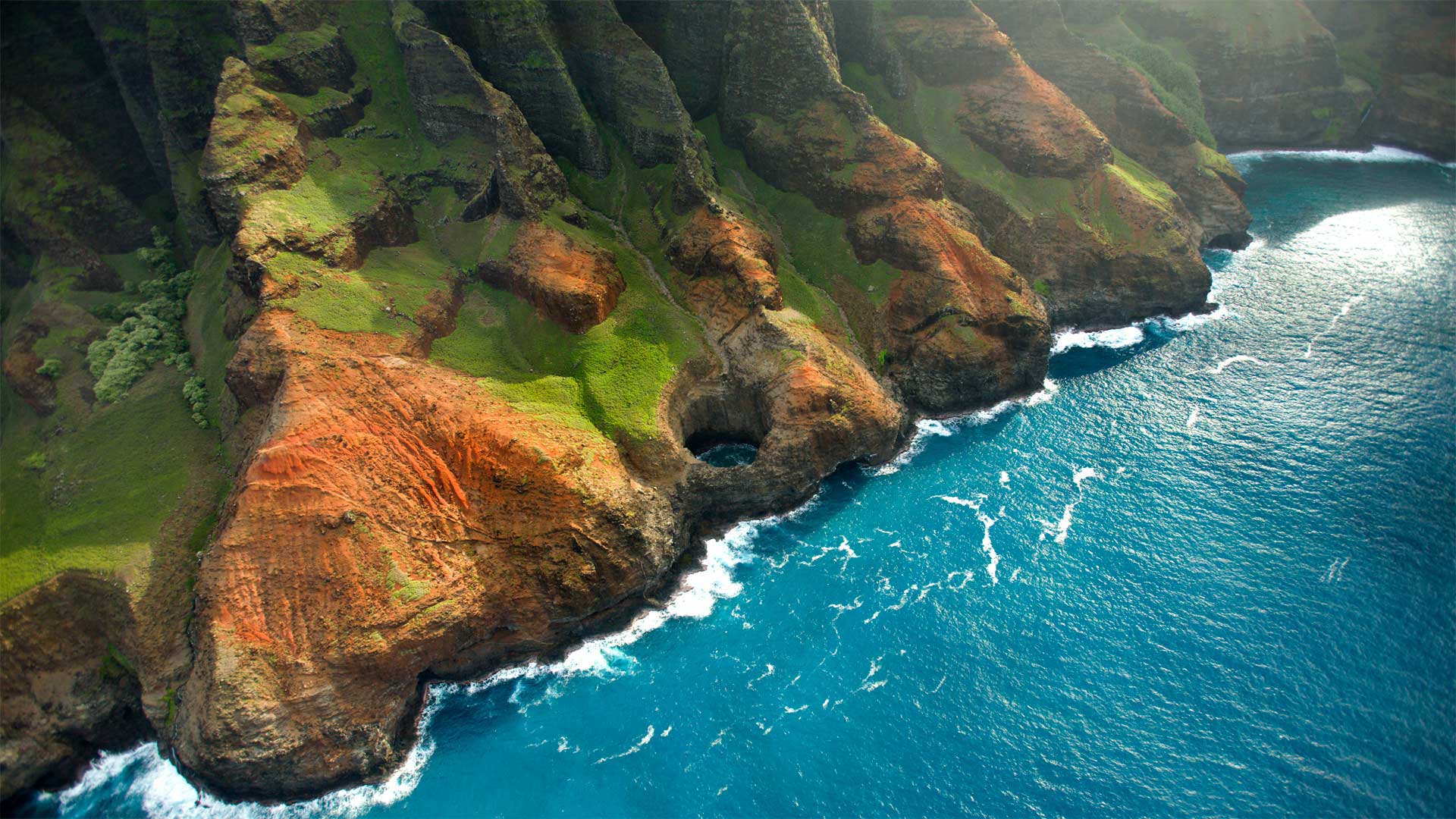
Nā pali海岸上的Bright Eye海蚀洞,夏威夷考艾岛 Bright Eye sea cave on the Nā Pali Coast, Kauai, Hawaii (© jimkruger/Getty Images)
Nā pali海岸上的Bright Eye海蚀洞,夏威夷考艾岛 Bright Eye sea cave on the Nā Pali Coast, Kauai, Hawaii (© jimkruger/Getty Images)
Just another day in paradise
It takes some effort to reach the stunning Nā Pali Coast on the Hawaiian island of Kauai. Located on the northwest side and stretching about 16 miles, Nā Pali isn't accessible by car. You have to hike in, fly in by helicopter, or come at it from the sea by boat. In the summer, when the waves are calm, you can explore the rugged coast by kayak, but you'll need a solid supply of muscle power for the sometimes-grueling paddle. If you seek a gentler approach—and if COVID restrictions allow—book a boat trip to explore the interiors of the sea caves that dot the shore. Today, we're looking down on the Bright Eye sea cave, one of several open-ceiling caves that lost their ceilings to the pounding of the sea.
又是天堂的一天
它需要一些努力,以达到惊人的Nā Pali夏威夷考艾岛的巴利海岸。位于西北侧,向北延伸约16英里Nā Pali岛不能开车去。你必须徒步旅行,乘直升飞机,或者乘船从海上来。在夏季,当海浪平静的时候,你可以用皮划艇探索崎岖的海岸,但是你需要一个坚实的肌肉力量来支撑有时会很费力的划桨。如果你寻求一个更温和的方法,如果科维德限制允许预订一个船旅行,探索内部的海洋洞穴点缀海岸。今天,我们俯瞰着明亮的眼睛海洞,它是几个开放式洞穴中的一个,因为海水的冲击而失去了它们的天花板。
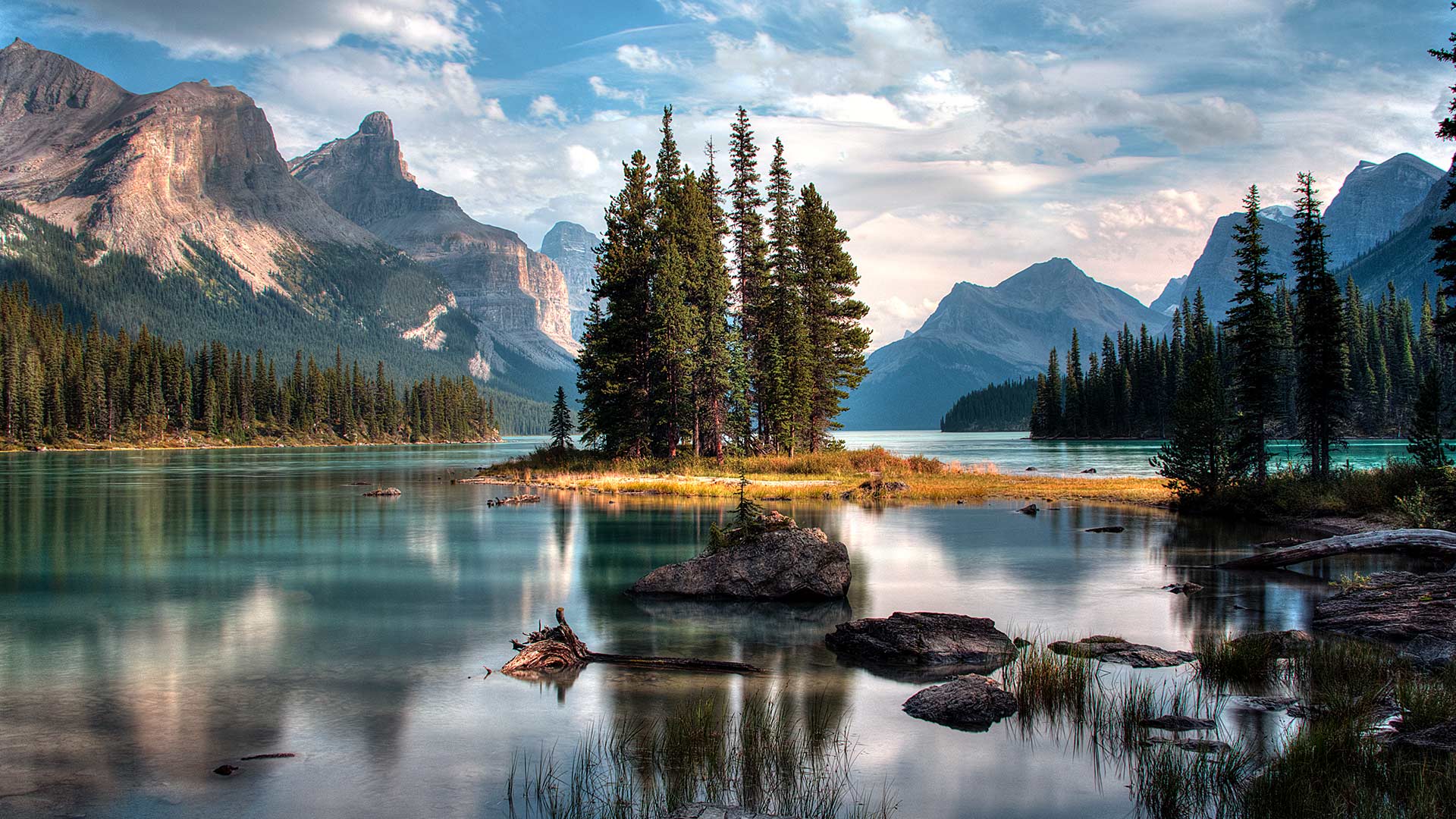
加拿大亚伯达省贾斯珀国家公园马利尼湖的精神岛 Spirit Island in Maligne Lake, Jasper National Park, Alberta, Canada (© Jeff Penner/EyeEm/Getty Images)
Spirit Island in Maligne Lake, Jasper National Park, Alberta, Canada (© Jeff Penner/EyeEm/Getty Images)
A photographer's paradise
If you are dreaming of an escape to paradise, look no further. Welcome to one of the most photographed sites in the majestic Canadian Rockies. Located in Jasper National Park in Alberta, the scenic Maligne Lake is 22 kilometres long, making it the largest natural lake out here. In the middle of this lake, sits the iconic Spirit Island which is only accessible via tour boats or private boats. The glacial, azure-blue waters, pine trees and snow-capped peaks frame Spirit Island, epitomizing the beauty of Jasper. In addition to admiring the natural beauty here, visitors can engage in activities such as hiking, fishing and kayaking during summer and skiing and snowshoeing in the winter.
摄影师的天堂
如果你梦想着逃往天堂,不要再看了。欢迎来到雄伟的加拿大落基山脉最受欢迎的景点之一。位于艾伯塔省贾斯珀国家公园,风景秀丽的马林湖长22公里,是这里最大的天然湖泊。在这个湖的中央,坐落着标志性的精神岛,只有通过旅游船或私人船只才能到达。冰川、湛蓝的海水、松树和白雪皑皑的山峰构成了精灵岛,是碧玉之美的缩影。除了欣赏这里的自然美景外,游客还可以在夏季进行徒步旅行、钓鱼和皮划艇活动,在冬季进行滑雪和雪鞋运动。
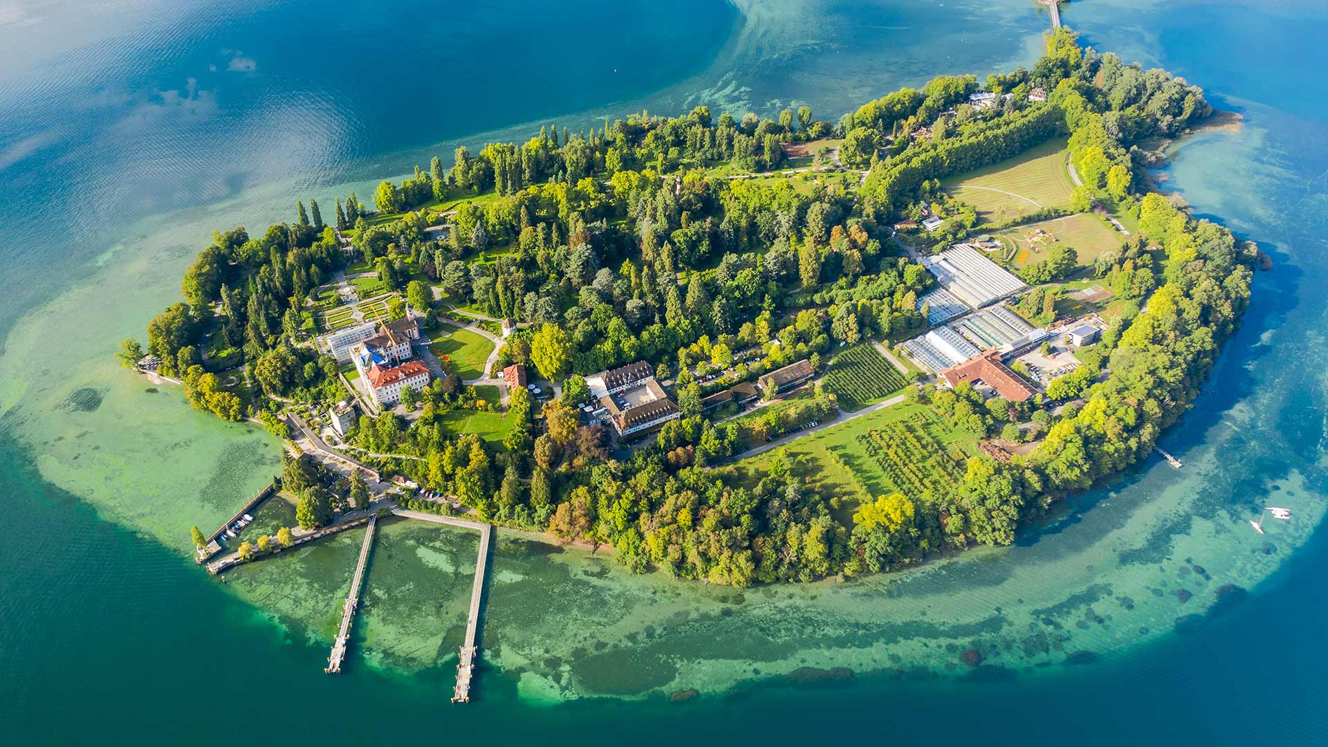
鸟瞰博登湖上的迈瑙岛,德国 Aerial view of the island of Mainau on Lake Constance, Germany (© Amazing Aerial Agency/Offset by Shutterstock)
鸟瞰博登湖上的迈瑙岛,德国 Aerial view of the island of Mainau on Lake Constance, Germany (© Amazing Aerial Agency/Offset by Shutterstock)
Welcome to the "flower island"!
From this height it is not immediately apparent why this island is nicknamed the “flower island”. But even a bird's eye view already suggests that the island of Mainau in Lake Constance is a special kind of natural experience - in every season of the year. Millions of tulips, daffodils and hyacinths bloom there in spring, rhododendrons, azaleas and roses can be admired in summer, dahlias bloom in autumn and in the cold months the island is transformed into a magical winter garden.
欢迎来到“花岛”!
从这个高度看,这个岛为什么被昵称为“花岛”还不清楚。但即使是鸟瞰图也已经表明,康斯坦斯湖的迈瑙岛是一种特殊的自然体验——在一年中的每一个季节。数百万的郁金香、水仙花和风信子在春天盛开,杜鹃花、杜鹃花和玫瑰在夏天可以欣赏,大丽花在秋天盛开,在寒冷的月份,岛上变成了一个神奇的冬季花园。