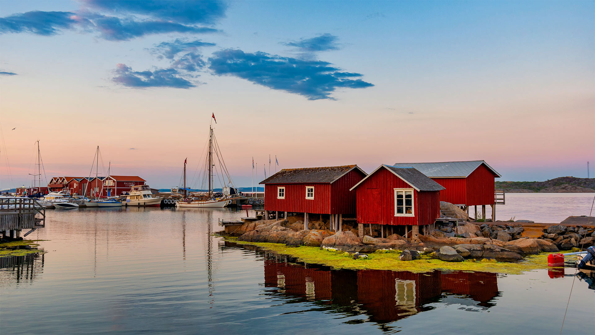
哥德堡群岛的岸边,瑞典 Island of Källö-Knippla in the archipelago of Gothenburg, Sweden (© Martin Wahlborg/Getty Images)
哥德堡群岛的岸边,瑞典 Island of Källö-Knippla in the archipelago of Gothenburg, Sweden (© Martin Wahlborg/Getty Images)
世界最臭食物之乡? Home of the 'world's worst smelling food'?
Surströmming Day
Get your clothespins ready, it's Surströmming Day! For the uninitiated, that means we're in Sweden and cracking open this year's surströmming harvest to enjoy its putrid wonder. Surströmming is Baltic herring that's been caught in April and May, then lightly salted and allowed to ferment. Beginning in the 1940s, a royal ordinance forbade the selling of Surströmming before the third Thursday in August to prevent incompletely fermented fish from being sold. The ordinance is no longer on the books, but the tradition holds.
Swedes indulge in pickled herring from bloated cans that most insist should be opened outside and preferably underwater. That's the recommended way to alleviate the stench from what some call 'the world's worst smelling food.' You may have seen popular 'challenge' videos of people trying to brave the experience and failing miserably. That's part of the fun, even if those videos are not the best representations of a true surströmming feast.
In today's photo, we're visiting a small fishing village on the island of Källö-Knippla in Gothenburg's northern archipelago. People there today might enjoy some surströmming on top of tunnbröd flatbread. It's common to then cover it in red onions, sour cream, and dill and then wash it all down with a shot of booze, a beer, or even milk. The taste is said to be very sharp, savory, and even acidic. That is, if you can keep it down. One food critic famously said that 'the biggest challenge when eating surströmming is to vomit only after the first bite, as opposed to before.'
酸鲱鱼日
准备好你的衣夹,今天是狂欢节!对于外行来说,这意味着我们在瑞典,打开今年的酸鲱鱼丰收,享受它腐烂的奇迹。酸鲱鱼是一种波罗的海鲱鱼,在4月和5月捕捞,然后轻轻腌制并发酵。从20世纪40年代开始,一项皇家法令禁止在8月的第三个星期四之前出售酸鲱鱼,以防止出售未完全发酵的鱼。这项法令已不再载入史册,但传统依然存在。
瑞典人沉迷于用膨胀的罐头腌制鲱鱼,大多数人坚持认为应该在室外打开,最好在水下打开。这是缓解被称为“世界上最难闻食物”的臭味的推荐方法你可能看过流行的“挑战”视频,视频中人们试图勇敢地面对这一经历,却惨遭失败。这是乐趣的一部分,即使这些视频不是真正的酸鲱鱼盛宴的最佳表现。
在今天的照片中,我们参观了哥德堡北部群岛Källö-Knippla岛上的一个小渔村。今天在那里的人们可能会喜欢在tunnbröd flatbread上吃些苏斯特罗姆面包。然后用红洋葱、酸奶油和莳萝将其覆盖,然后用一杯酒、一杯啤酒甚至牛奶将其冲洗干净,这是很常见的。据说它的味道非常尖锐、可口,甚至呈酸性。也就是说,如果你能控制住它。一位美食评论家有一句名言:“吃苏斯特罗姆食物时最大的挑战是只在第一口之后呕吐,而不是之前。”
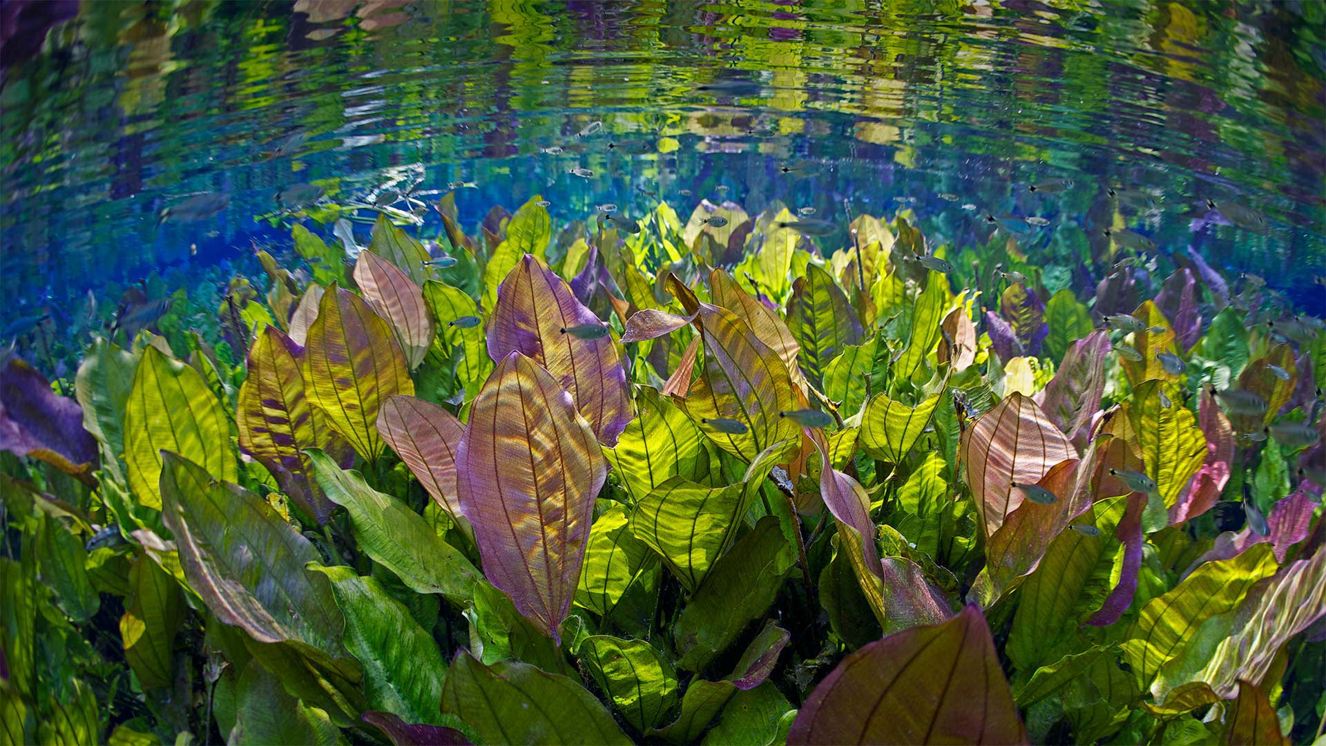
大自然的水族馆中的水下景观,巴西 Underwater river scene with freshwater plants and tetra fish, Aquário Natural, Rio Baia Bonito, Mato Grosso do Sul, Brazil (© Michel Roggo/Minden Pictures)
大自然的水族馆中的水下景观,巴西 Underwater river scene with freshwater plants and tetra fish, Aquário Natural, Rio Baia Bonito, Mato Grosso do Sul, Brazil (© Michel Roggo/Minden Pictures)
如此清澈,如此洁净 So fresh, so clean
Freshwater plants in Aquario Natural, Brazil
Aquário Natural (Natural Aquarium, naturally) is the pristine, crystal-clear source of the Baía Bonita River and a highlight of the Baía Bonita Ecological Reserve. This remote inland region of Brazil is a popular spot for eco-tourism. A tour of the Aquário Natural offers a hike through the jungle followed by snorkeling with over 30 varieties of fish and gorgeous vegetation to marvel at. Other popular activities of the area include swimming the Silver River, rappelling 236 feet down into the waters of the Anhumas Abyss, and walking through the treetops on the suspended steel walkway of the Circuito Arvorismo (The Trees Circuit).
The underwater scene in today's image of plants and tetra fish was photographed by Swiss artist Michel Roggo. Since 2010, Roggo has crisscrossed the world in search of the most beautiful freshwater environments. His work has taken him to 48 locations where he has taken more than 12,000 photographs. His projects highlight the need to protect unsullied locations and to safeguard the world's wetlands and freshwater ecosystems.
巴西Aquario Natural的淡水植物
阿奎里奥自然水族馆(Natural Aquario,Natural)是巴尼亚博尼塔河的原始、清澈的源头,也是巴尼亚博尼塔生态保护区的一大亮点。巴西这个偏远的内陆地区是生态旅游的热门景点。阿奎里奥自然之旅提供了一次穿越丛林的徒步旅行,然后是30多种鱼类和华丽植被的浮潜。该地区其他受欢迎的活动包括在银河上游泳,用绳索将236英尺的水降到Anhumas深渊的水中,以及在Circuito Arvorismo(树木赛道)的悬挂式钢制走道上穿过树梢。
今天的植物和鱼类图片中的水下场景是由瑞士艺术家米歇尔·罗格拍摄的。自2010年以来,罗格在世界各地寻找最美丽的淡水环境。他的工作带他去了48个地方,在那里他拍了12000多张照片。他的项目强调了保护无污染地点和保护世界湿地和淡水生态系统的必要性。
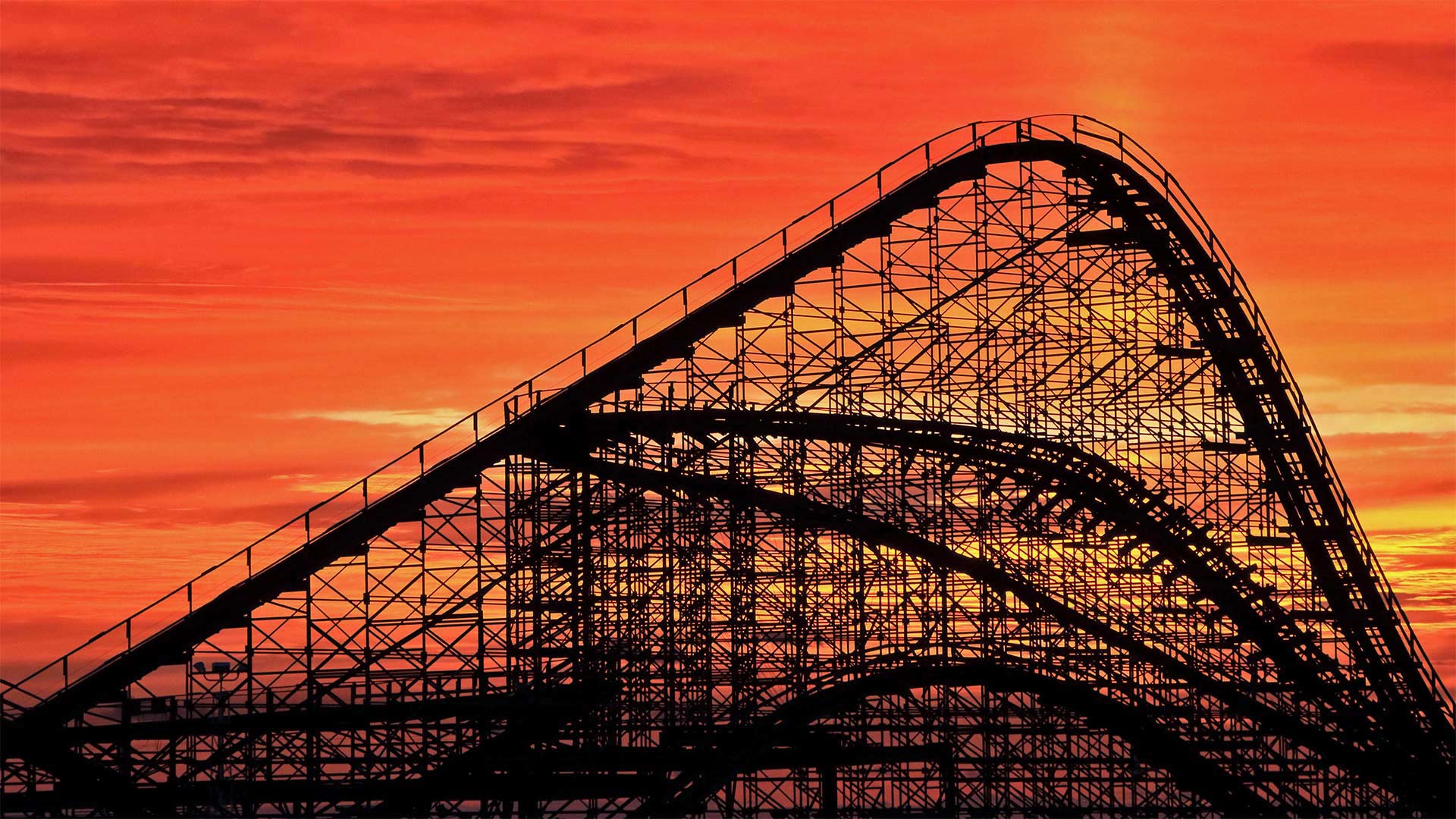
夕阳下的大白鲨过山车,美国新泽西州 The Great White Roller Coaster at Wildwood, New Jersey (© John Van Decker/Alamy)
夕阳下的大白鲨过山车,美国新泽西州 The Great White Roller Coaster at Wildwood, New Jersey (© John Van Decker/Alamy)
惊险之旅 Thrill ride
The Great White Roller Coaster
To really get the feel for today's photo, stop what you're doing, put your hands in the air, and imagine yourself plunging downhill at 50 miles an hour. Screaming is optional. We're waiting in line at Morey's Piers in Wildwood, New Jersey, for our ride on The Great White. A hybrid wooden and steel coaster, it's been in operation since 1996 and reaches its highest point 110 feet above the ground. Coaster enthusiasts point out the ride's dip under the pier shortly after the start as one of its highlights. It's also noted for a portion of the ride swinging out over the nearby beach.
Roller coasters have come a long way since their early days beginning in the 17th century as Russian sled rides. Eventually called Russian Mountains, those original rides were just tall, wooden ramps covered in ice. When the concept made its way to much warmer France, the sleds made their way across the tracks on wooden rollers, hence the name 'roller coasters.' Coasters saw another advancement in the 1800s when a Pennsylvania mining company built a downhill gravity railroad to transport coal. Its train cars held double duty by giving thrill rides to tourists during downtime. By 1919, coasters had entered their 'golden age' with fully formed rides all over the world. The desire to experience greater heights and faster drops mean the sky's the limit when it comes to coaster design. These days, in the United States alone, thrill seekers take roughly 1.7 billion rides per year across more than 800 coasters.
大白色过山车
为了真正了解今天的照片,停止你正在做的事情,把手举到空中,想象你以每小时50英里的速度下山。尖叫是可选的。我们在新泽西州Wildwood的Morey‘s Piers排队等候乘坐大白鲨。这是一款木制和钢制的混合过山车,自1996年起投入使用,最高点离地110英尺。过山车爱好者指出,在出发后不久,过山车在码头下的下沉是其亮点之一。它还以一部分骑行在附近的海滩上摇摆而闻名。
过山车从17世纪开始作为俄罗斯雪橇运动以来已经走过了漫长的道路。这些最初的游乐设施最终被称为俄罗斯山脉,它们只是覆盖着冰的高大木质坡道。当这个概念传播到气候暖和得多的法国时,雪橇在木制滚轮上穿过轨道,因此得名“过山车”19世纪,当宾夕法尼亚州的一家矿业公司建造了一条下坡重力铁路来运输煤炭时,过山车迎来了另一个进步。它的火车车厢承担着双重职责,在停工期间为游客提供惊险刺激的乘坐体验。到1919年,云霄飞车已进入其“黄金时代”,全世界都有完整的云霄飞行设施。想要体验更高的高度和更快的下降速度,这意味着在过山车设计方面,天空是极限。如今,仅在美国一地,寻求刺激的人每年就要乘坐超过800辆过山车,约17亿次。
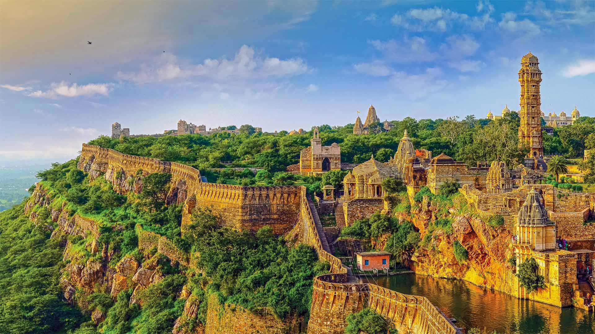
奇陶尔加尔堡,印度 Chittorgarh Fort, India (© Anand Purohit/Getty Images)
奇陶尔加尔堡,印度 Chittorgarh Fort, India (© Anand Purohit/Getty Images)
Chittorgarh Fort Rajasthan India
At 8 miles in circumference, the Chittorgarh Fort is one of the largest forts in India, a nation with scores of ancient and medieval fortresses. For starters there are seven massive gates from which to enter. Inside you'll find four palaces and 19 temples. At one time there were almost 100 bodies of water, most of them ponds fed by natural catchment and rainfall, although now there are only 20. Chittorgarh ('garh' means 'fort,' so it's also known as Chittor Fort) is so old, no one is sure exactly when it was built, although reports of its earliest capture go back to the 8th century. It is one of a cluster of six large forts in the northwestern state of Rajasthan referred to as the Hill Forts of Rajasthan, all of them collectively designated a UNESCO World Heritage Site. We're featuring this important and ancient complex on India's 75th Independence Day, one of India's three national holidays.
On August 15, 1947, India officially broke free of Great Britain and became a sovereign and democratic nation with the speedy passage of the Indian Independence Act. The paperwork might have been fast, but the struggle for independence from British rule lasted 90 years and cost many Indian lives. The British controlled the Indian subcontinent for nearly 200 years, after winning the decisive Battle of Plassey in 1757. The victory allowed the English East India Company to eventually exercise control over most of the rest of the Indian subcontinent, Burma, and Afghanistan. East India remained the supreme authority in India for a century until 1857 when a massive rebellion by civilians and Indian soldiers against the company was suppressed, resulting in direct British rule, referred to as the British raj.
The ensuing decades saw the formation of the Indian National Congress, the rise of Indian nationalism, various armed rebellions, and many acts of civil disobedience led by Mahatma Gandhi and others, before independence was finally achieved. While India as we know it is still a very young nation, the Chittor Fort reminds us the land and people that created modern India have endured and thrived for millennia.
印度拉贾斯坦邦的奇托加尔堡
奇托加尔要塞周长8英里,是印度最大的要塞之一,该国拥有数十座古代和中世纪要塞。首先,有七扇巨大的大门可以进入。里面有四座宫殿和19座寺庙。曾经有近100个水体,其中大部分是由自然集水和降雨形成的池塘,尽管现在只有20个。奇托加尔(Chittorgar,意为“堡垒”,所以也被称为奇托堡)非常古老,没有人确切知道它是何时建成的,尽管关于最早捕获的报道可以追溯到8世纪。它是西北部拉贾斯坦邦的六座大型堡垒群之一,被称为拉贾斯坦山的希尔堡垒,所有这些堡垒都被联合国教科文组织列为世界遗产。在印度的第75个独立日,印度的三个法定假日之一,我们将展示这座重要而古老的建筑群。
1947年8月15日,随着《印度独立法》的迅速通过,印度正式脱离英国,成为一个主权民主国家。文书工作可能很快,但脱离英国统治的独立斗争持续了90年,夺走了许多印度人的生命。1757年,英国人在普拉西决定性战役中获胜后,控制了印度次大陆近200年。这场胜利使英国东印度公司最终控制了印度次大陆的大部分其他地区,缅甸和阿富汗。一个世纪以来,东印度一直是印度的最高权力机构,直到1857年,平民和印度士兵对该公司的大规模叛乱被镇压,导致英国直接统治,称为英国统治。
随后的几十年见证了印度国民大会的成立、印度民族主义的兴起、各种武装叛乱以及圣雄甘地等人领导的许多公民不服从行为,最终实现了独立。虽然我们所知的印度仍然是一个非常年轻的国家,但奇托堡提醒我们,创造现代印度的土地和人民已经忍受并繁荣了数千年。
独木舟区的边界水域, 苏必利尔国家森林荒野, 明尼苏达州 Boundary Waters Canoe Area Wilderness, Superior National Forest, Minnesota (© Dukas/Universal Images Group via Getty Images)
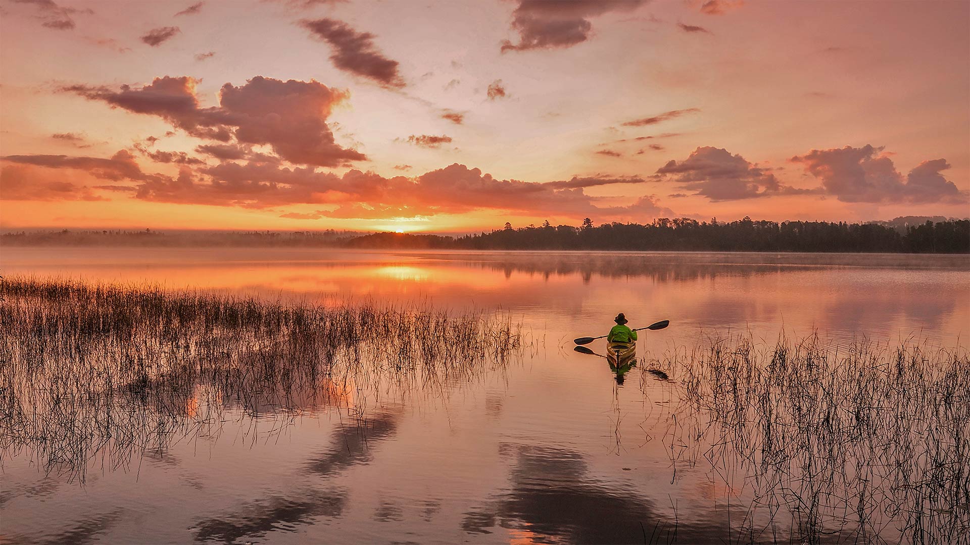
独木舟区的边界水域, 苏必利尔国家森林荒野, 明尼苏达州 Boundary Waters Canoe Area Wilderness, Superior National Forest, Minnesota (© Dukas/Universal Images Group via Getty Images)
独木舟 Canoeing in solitude
Boundary Waters Canoe Area Wilderness
If you're in the mood for a quiet canoe ride, you must take a trip to Boundary Waters Canoe Area Wilderness (BWCAW) in northeast Minnesota. In today's photo, we're on Birch Lake but the Boundary Waters wilderness as a whole stretches for 150 miles along the US-Canada border within Superior National Forest. Known by those seeking solitude, Boundary Waters is one of America's most beautiful and remote locations. Formed long ago from the scraping and gouging of glaciers, the area is distinct with its rugged cliffs, canyons, and thousands of lakes and streams. More than 1,500 miles of canoe routes are enjoyed by thousands of people every year.
Canoeing the many waterways may be the main draw, but 80% of the area is forest. In fact, the Boundary Waters wilderness contains the largest swath of uncut forest in the eastern portion of the United States. That's even after the 1999 'Boundary Waters blowdown,' a powerful July 4 derecho storm that lasted 22 hours and took down millions of trees with its 100 mile-per-hour winds. Many animals call the forested area home, including the largest population of wolves in the contiguous states.
If you're more of a night owl, the Boundary Waters wilderness offers a unique opportunity. In 2020, the area was designated one of only 15 Dark Sky Sanctuaries around the world by the International Dark Sky Association. This differs from a normal Dark Sky designation in that its fragile landscape is one of the planet's most remote locations, free of light pollution and ideal for night sky observation. The point is, night or day, you're sure to find something worth your time at the Boundary Waters.
明尼苏达边界水域
如果你想安静地乘坐独木舟,你必须去明尼苏达州东北部的边界水域独木舟区荒野(BWCAW)。在今天的照片中,我们在桦树湖上,但边界水域荒野作为一个整体沿着美加边境延伸150英里,位于高级国家森林内。边境水域是美国最美丽、最偏远的地方之一,被那些寻求独处的人所熟知。这个地区是在很久以前由冰川的刮削和凿削形成的,有着崎岖的悬崖、峡谷和数千条湖泊和溪流。每年有数千人享受1500多英里的独木舟路线。
在许多水道上划独木舟可能是主要的吸引力,但80%的区域是森林。事实上,边界水域荒野包含美国东部最大的未开垦森林带。甚至在1999年的“边界水域排污”之后,7月4日的一场强大的德雷乔风暴持续了22小时,以每小时100英里的速度刮倒了数百万棵树。许多动物称森林地区为家,包括毗邻各州数量最多的狼。
如果你更喜欢夜猫子,边境水域荒野提供了一个独特的机会。2020年,该地区被国际黑暗天空协会指定为全世界仅有的15个黑暗天空保护区之一。这与普通的黑暗天空不同,因为它脆弱的景观是地球上最偏远的地方之一,没有光污染,非常适合夜空观测。关键是,无论白天还是黑夜,你一定会在边界水域找到值得你花费时间的东西。
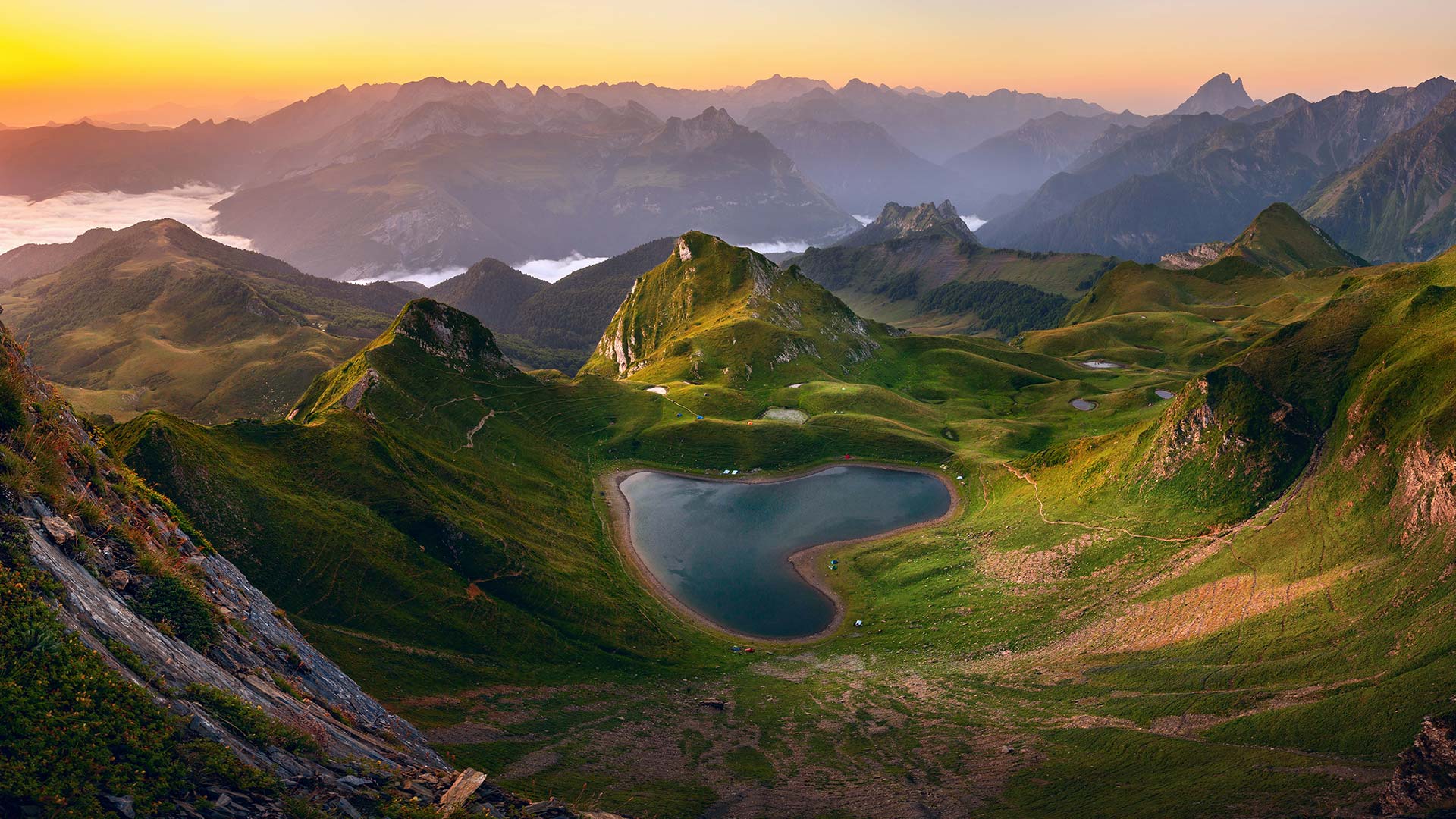
阿斯佩山谷中的蒙塔尼翁湖,法国 (© thieury/Adobe photo stock)
日本长野县安昙野附近的燕岳山 Mount Tsubakuro near Azumino, Nagano, Japan (© Joshua Hawley/Getty Images)
日本长野县安昙野附近的燕岳山 Mount Tsubakuro near Azumino, Nagano, Japan (© Joshua Hawley/Getty Images)
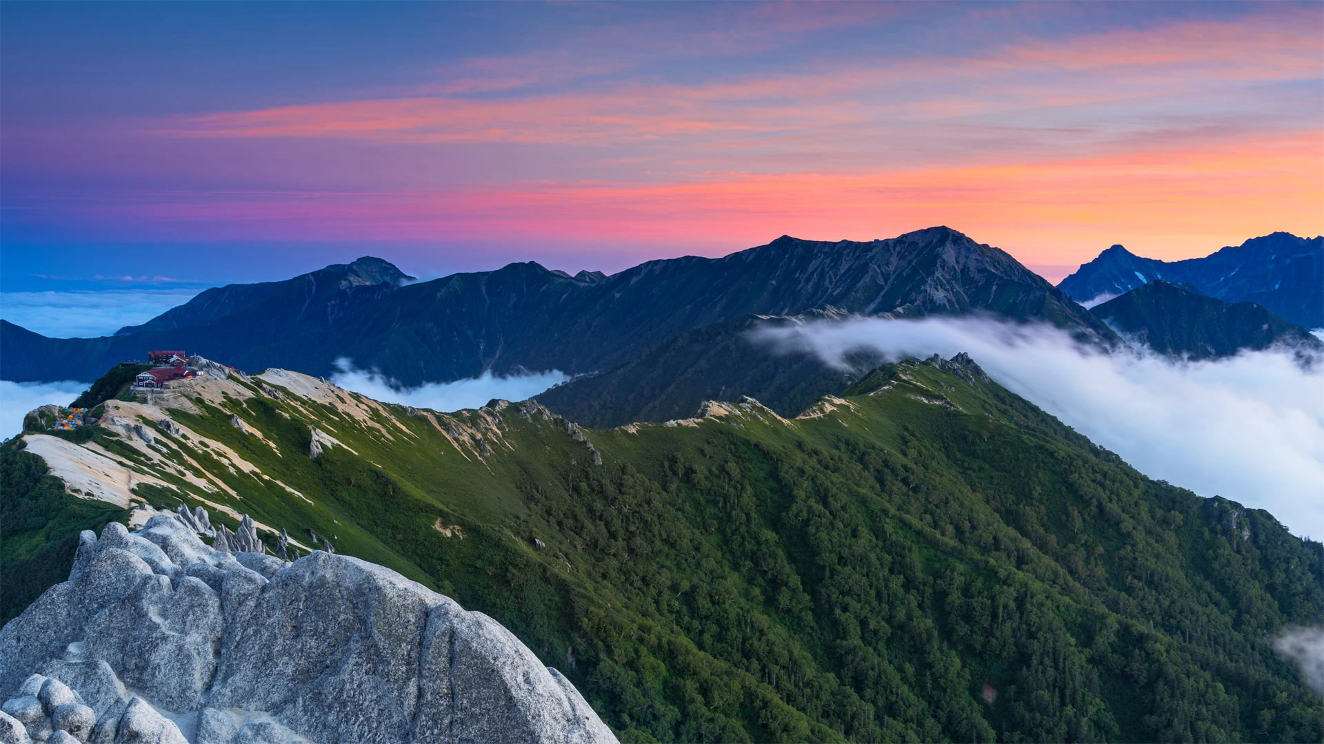
如果可以的话,请拥抱一座山吧 Go hug a mountain, if you can
It's Mountain Day in Japan
It makes a mountain of sense for Japan to celebrate Mountain Day, which occurs each August 11. Created in 2014, it's one of Japan's newest holidays. Nearly three quarters of the country is made up of mountains, thanks to its location on the Pacific Ring of Fire volcanic zone. Japan's four major islands—Honshu, Hokkaido, Kyushu, and Shikoku—all have ranges running through them.
The 9,065-foot Mt. Tsubakuro, which we feature in our home page image today, is a popular hiking destination, with well-maintained trails, rest areas, and lodges. Beautiful scenery abounds here on the island of Honshu, less than three hours' driving distance from Tokyo.
According to the legislation that established Mountain Day, the observance was launched to provide 'opportunities to get familiar with mountains and appreciate blessings from mountains.' One of those is snow-capped Mount Fuji, Japan's tallest mountain (12,389 feet) and one of the most pictured peaks in the world. Japan's rugged terrain is a boon for its tourist industry, providing opportunities for skiing, climbing, and resorts featuring the country's many hot springs.
今天是日本的山地日
对于日本来说,庆祝每年8月11日的“山岳日”意义重大。该节日创建于2014年,是日本最新的节日之一。该国近四分之三的地区由山脉组成,这要归功于它位于太平洋火环火山区。日本的四个主要岛屿本州岛、北海道岛、九州岛和四国岛都有山脉穿过。
我们今天在主页上展示的9065英尺的Tsubakuro山是一个受欢迎的徒步旅行目的地,有维护良好的小径、休息区和小屋。离东京不到三小时车程的本州岛上有很多美丽的风景。
根据设立“山岳日”的立法,发起这项活动是为了“有机会熟悉山岳,欣赏山岳的祝福”其中一座是被白雪覆盖的富士山,日本最高的山峰(12389英尺),也是世界上照片最多的山峰之一。日本崎岖的地形对其旅游业是一个福音,为滑雪、登山和以该国众多温泉为特色的度假胜地提供了机会。
约书亚树,加利福尼亚州约书亚树国家公园 Joshua trees in Joshua Tree National Park, California (© Tim Fitzharris/Minden Pictures)
约书亚树,加利福尼亚州约书亚树国家公园 Joshua trees in Joshua Tree National Park, California (© Tim Fitzharris/Minden Pictures)
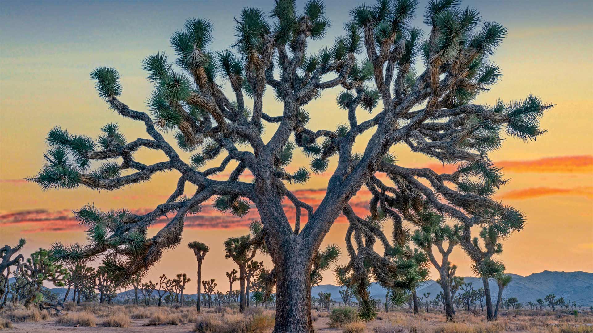
沙漠中的匕首? Desert daggers?
Joshua Tree National Park
These immensely photogenic and relatable trees, their shaggy, sinewy limbs thrust upward into the pale light of the desert sky, are the main reason people come here to California's Joshua Tree National Park. Joshua Tree was declared a national monument on August 10, 1936, before being designated a national park in 1994. Perhaps no other national park is so completely defined by a single feature, be it a plant or wildlife or natural formation. While Joshua Tree National Park contains other wonders, this tree that looks drawn by Dr. Seuss is what visitors come to celebrate.
The park (and the town of the same name) could also be called the hippest national park in the country, owing to its proximity to Los Angeles, and the Insta-worthy, charismatic flora that have helped make JT a darling on social media. Van lifers, artists, celebrities, and other creative bohemians have fueled a boom in tourism, not just to the park itself, but to the surrounding towns, like Pioneertown. The kitschy outpost served as an old Hollywood set and is now a center of nightlife in the area. Pappy & Harriet's Pioneertown Palace serves artisanal cocktails with its barbecue and features live music, sometimes from the likes of Paul McCartney, Robert Plant, and Patti Smith. And if you can't find an elderflower martini in Joshua Tree, then Palm Springs and Indio and Coachella are a short drive away, something Yellowstone and Yosemite can't claim.
But for those going purely for the nature—the hikers, rock climbers, campers, and stargazers—the 1,200-square-mile park is no less a marvel. Two deserts, the high-elevation Mojave and the low-elevation Colorado, merge here, each with its own ecosystem. The Joshua tree itself grows only on the Mojave side, at elevations between 1,300 and 5,900 feet. Most of the world's Joshua trees are found here. A variety of yucca, Joshua trees live to be 500 and 1,000 years old with roots as deep as 35 feet. Most believe their name was first concocted by Mormon pioneers who likened their branches to the oustretched arms of the biblical Joshua. It proved catchier than its botanical name, Yucca brevifolia. And as any influencer worth their followers will tell you, it makes for a much more memorable hashtag.
约书亚树国家公园
这些非常上镜且相互关联的树木,它们粗壮有力的四肢伸向沙漠天空的暗淡光线,是人们来到加利福尼亚州约书亚树国家公园的主要原因。约书亚树于1936年8月10日被宣布为国家纪念碑,然后于1994年被指定为国家公园。也许没有其他国家公园如此完全由单一特征来定义,无论是植物、野生动物还是自然形成物。约书亚树国家公园还有其他的奇观,这棵树看起来是苏斯博士画的,是游客们来庆祝的。
这个公园(和同名的小镇)也可以被称为美国最时髦的国家公园,因为它靠近洛杉矶,以及有魅力的植物群,使JT成为社交媒体上的宠儿。范利弗、艺术家、名人和其他富有创意的波西米亚人推动了旅游业的繁荣,不仅是公园本身,还有周边城镇,如先锋镇。这个俗气的前哨站曾经是好莱坞的老片场,现在是该地区的夜生活中心。Pappy&Harriet的先锋城宫殿提供手工鸡尾酒和烧烤,并配有现场音乐,有时来自保罗·麦卡特尼(Paul McCartney)、罗伯特·普兰特(Robert Plant)和帕蒂·史密斯(Patti Smith)。如果你在约书亚树上找不到接骨木花马提尼酒,那幺棕榈泉、Indio和Coachella就在很短的车程之外,这是黄石公园和约塞米蒂不能宣称的。
但对于那些纯粹为了大自然而去的徒步旅行者、攀岩者、露营者和观星者来说,1200平方英里的公园同样是一个奇迹。两个沙漠,高海拔的莫哈韦和低海拔的科罗拉多,在这里汇合,每个沙漠都有自己的生态系统。约书亚树本身只生长在莫哈韦一侧,海拔在1300到5900英尺之间。世界上大多数约书亚树都在这里找到。各种各样的丝兰树、约书亚树的树龄分别为500年和1000年,树根深达35英尺。大多数人相信他们的名字是摩门教先驱们首先炮制出来的,他们把他们的树枝比作圣经中约书亚被驱逐的手臂。事实证明,它比其植物学名称短叶丝兰更吸引人。任何有影响力的追随者都会告诉你,这是一个更令人难忘的标签。
阿根廷圣克鲁斯的洛斯马诺斯洞穴 Cueva de las Manos (Cave of the Hands) in Santa Cruz, Argentina (© Adwo/Alamy)
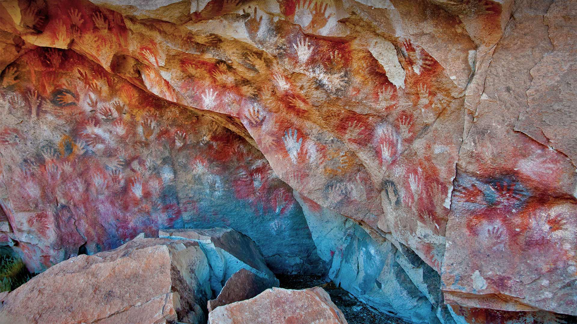
阿根廷圣克鲁斯的洛斯马诺斯洞穴 Cueva de las Manos (Cave of the Hands) in Santa Cruz, Argentina (© Adwo/Alamy)
9000年前的手印 9,000-year-old handprints
International Day of the World's Indigenous Peoples
What at first glance appears to be graffiti tagged on a rock wall is, in fact, artwork created by the first human settlers of this remote region deep in Argentine Patagonia. It's thought that the cave paintings were made between 13,000 and 9,500 years ago. The archaeological site is known in Spanish as the Cueva de las Manos (Cave of the Hands). It's the largest display of prehistoric handprints in the world, made all those years ago by people holding a hand against the rock wall and blowing pigments through tubes made of bone. Of the 829 black, white, red, and ochre prints, most are of young male hands. One print has six fingers, and only 31 are of right hands.
The cave paintings were created in at least three waves over thousands of years by ancestors of the Tehuelche people. Archaeologists have hypothesized that the artists were hunter-gatherers. This theory is supported by the fact that even older than the handprints are depictions of guanacos (a relative of the llama, and the main source of food at the time); rheas (large flightless birds); and hunting scenes.
Today, more than 370 million Indigenous people live in various regions of the world, like the Teheulche, who continue to live in Patagonia near the southern border between Argentina and Chile. To honor and protect the rights of the world's current Indigenous populations, the UN marks each August 7 as International Day of the World's Indigenous Peoples. We'll raise our hands in support of that.
世界土著人民国际日
乍一看,岩壁上的涂鸦标记实际上是阿根廷巴塔哥尼亚这个偏远地区的第一批人类定居者创作的艺术品。据认为,这些洞穴壁画是在13000年至9500年前绘制的。该考古遗址在西班牙语中被称为Cueva de las Manos(手洞)。这是世界上最大规模的史前手印展示会,多年前,人们用手抵着岩壁,用骨头制成的管子吹颜料。在829张黑、白、红和赭色的照片中,大多数是年轻男性的手。一个指纹有六个手指,只有31个是右手的。
这些洞穴壁画是特韦尔奇人的祖先在数千年中至少三次创作的。考古学家假设这些艺术家是狩猎采集者。这一理论得到了以下事实的支持:比手印更古老的是美洲驼(美洲驼的亲戚,当时的主要食物来源)的描述;大型不会飞的鸟类;还有狩猎场面。
今天,有3.7亿多土著人生活在世界各地,如特霍尔切人,他们继续生活在阿根廷和智利南部边界附近的巴塔哥尼亚。为了尊重和保护当今世界土著居民的权利,联合国每年8月7日都将其定为世界土著人民国际日。我们将举手表示支持。
圣埃尔姆附近的潘塔留岛鸟瞰图,西班牙马略卡岛 Aerial view of the island Pantaleu near Sant Elm, Mallorca, Spain (© Dimitri Weber/Azing航空公司)
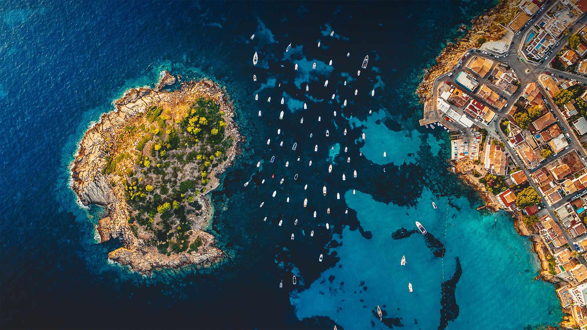
圣埃尔姆附近的潘塔留岛鸟瞰图,西班牙马略卡岛 Aerial view of the island Pantaleu near Sant Elm, Mallorca, Spain (© Dimitri Weber/Azing航空公司)
汪洋中的小岛 Little Island, Big Sea
Pantaleu
There isn't much to the tiny island of El Pantaleu (or Es Pantaleu in Catalan), cast off the westernmost shore of Mallorca, itself a relatively small island only 30-40 miles across. Pantaleu and Mallorca are part of the archipelago of Balearic Islands in the Balearic Sea, off the east coast of Spain. Mallorca, Ibiza, Menorca, and Formentera are the chain's four major islands and are famous as tourist destinations popular among those seeking the warm Mediterranean climate and inviting shoreline.
Pantaleu is more precisely an islet, a mere rock of about six acres in size. Its highest point is 80 feet. Not much grows on El Pantaleu, and no one lives on it. Mallorca is only about 1,000 feet away, making it a vigorous but doable swim for the many who have tried from the beach at the village of Sant Elm. Technically, no one is allowed to step foot onto Pantaleu, because it is designated a nature reserve along with the much larger Dragonera Island a few miles farther to the west.
Pantaleu is most useful as a wind break for boats, as you can see from this aerial photo. The notch between the islet and the main island is a popular anchorage for the many pleasure boats that cruise these waters. Even centuries ago, sailors understood the value of Pantaleu as an anchorage. In 1229, young James I the Conqueror, King of Aragon, and his fleet sought refuge from a storm behind Pantaleu before he embarked on his campaign to invade the Balearic Islands and start making good on his nickname. These days, most of the turf battles around here have been settled, although you might have to parry a vacationer for a spot on the sand or a table at happy hour.
潘塔留
位于马略卡岛最西岸的小岛El Pantaleu(或加泰罗尼亚的Es Pantaleau)没有什么特别之处,它本身是一个直径只有30-40英里的相对较小的岛屿。Pantaleu和Mallorca是西班牙东海岸巴利阿里海巴利阿里群岛的一部分。马洛卡岛、伊维萨岛、梅诺卡岛和福门特拉岛是该群岛的四个主要岛屿,是著名的旅游目的地,深受寻求温暖地中海气候和迷人海岸线的游客的欢迎。
潘塔留更准确地说是一个小岛,一块只有六英亩大小的岩石。它的最高点是80英尺。El Pantaleu岛上没有多少植物,也没有人靠它生活。马略卡岛离这里只有1000英尺远,对于许多在圣埃尔姆村海滩上尝试游泳的人来说,这是一次充满活力但可行的游泳。从技术上讲,任何人都不允许踏上潘塔留岛,因为它被指定为自然保护区,与西边几英里远的大得多的龙时代岛一起。
从这张航拍照片中可以看出,Pantaleu是船只避风的最佳场所。小岛和主岛之间的缺口是许多游船在这些水域航行的热门锚地。甚至在几个世纪前,水手们就知道潘塔留作为锚地的价值。1229年,年轻的征服者、阿拉贡国王詹姆斯一世和他的舰队在开始入侵巴利阿里群岛并开始利用他的绰号之前,在潘塔留后面躲避风暴。这些天来,这里的大部分地盘之争都已经解决了,尽管你可能不得不避开度假者在沙滩上或欢乐时光的餐桌上。