毛伊岛附近的座头鲸,美国夏威夷 Humpback whales, Maui, Hawaii (© Flip Nicklin/Minden Pictures)
毛伊岛附近的座头鲸,美国夏威夷 Humpback whales, Maui, Hawaii (© Flip Nicklin/Minden Pictures)
海洋之王 King of the ocean
毛伊岛鲸鱼节
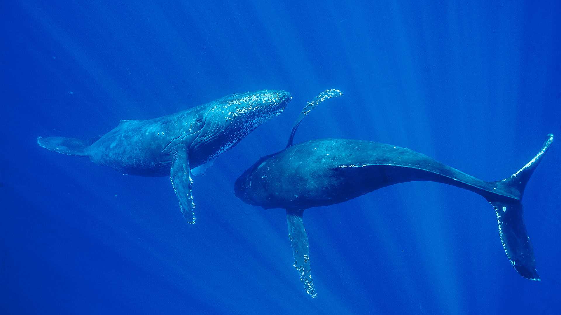
在座头鲸巨大体型的衬托之下,你会觉得自己是如此的渺小。成年座头鲸体长达46-56英尺以上,是地球上最大的哺乳动物之一。夏威夷毛伊岛每年都会举办鲸鱼节,游客们可以参加观鲸活动,近距离接触这些美丽的庞然大物。座头鲸是须鲸的一种,以擅长唱歌而闻名,它们嘹亮优美的歌声甚至可以在水中传到“千里之外”。有趣的是,每个鲸鱼群都有自己的鲸歌,并且只有雄性鲸鱼才唱歌。此外,鲸鱼还是河马的远亲,它们是从同一个祖先进化而来。
Humpback whales in Maui, Hawaii
If you ever want to feel insignificant, just think about the sheer size of a humpback whale. With adults growing up to more than 46-56 feet, humpback whales are one of the biggest mammals on Earth. In Hawaii, you can get the opportunity to go on a whale-watching tour during the Maui Whale Festival and get up close with these giant, beautiful creatures. A species of baleen whale, humpback whales are known for their long elaborate songs, which travel far distances through the waters. Each whale population has its own song, and interestingly, it is only the males that sing. Also, did you know that whales are distant relatives of hippos? Both species evolved from a common ancestor.
“火流”马尾瀑布,约塞米蒂国家公园,美国加利福尼亚州 'Firefall' on Horsetail Fall, Yosemite National Park, California (© Jeff Lewis/Tandem Stills + Motion)
“火流”马尾瀑布,约塞米蒂国家公园,美国加利福尼亚州 'Firefall' on Horsetail Fall, Yosemite National Park, California (© Jeff Lewis/Tandem Stills + Motion)
这个悬崖怎么着火了? Why is this cliffside ablaze?
马尾瀑布,约塞米蒂国家公园,加利福尼亚州
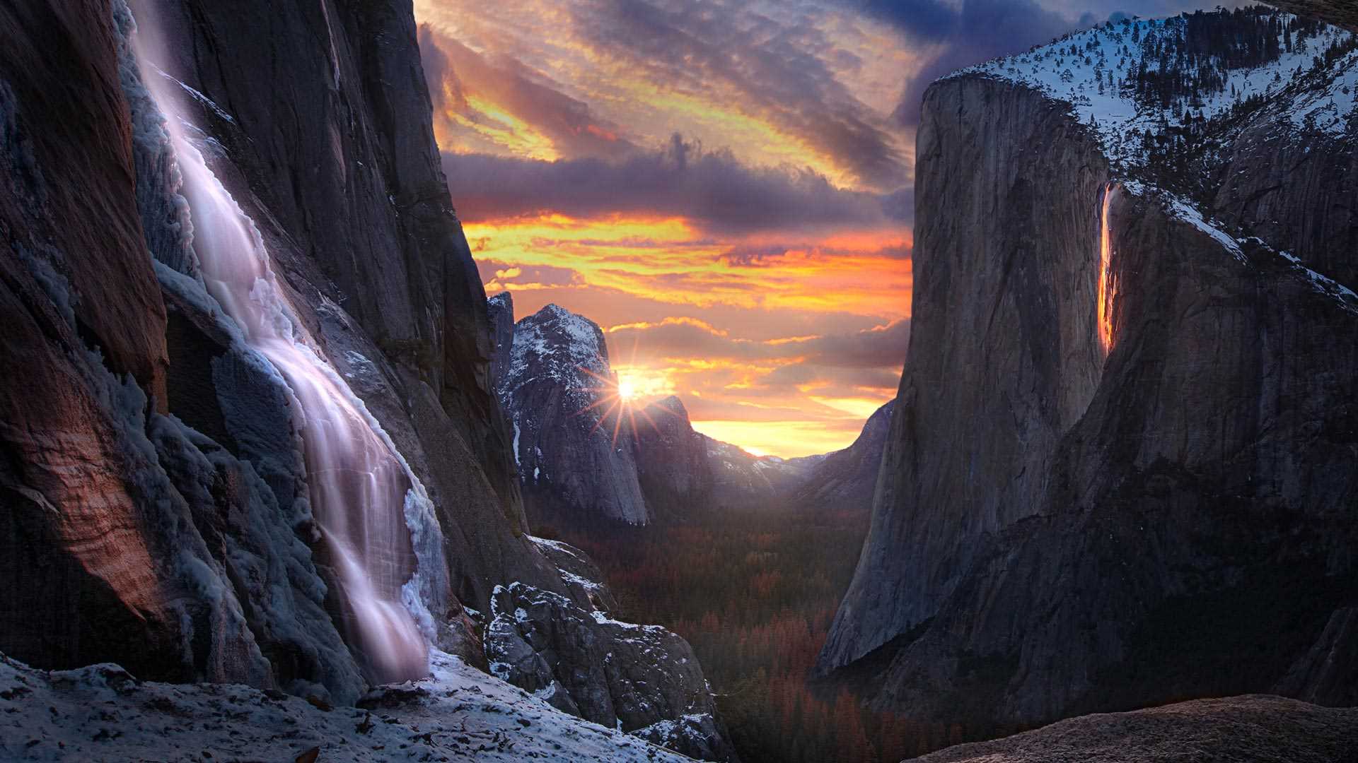
在约塞米蒂国家公园的埃尔卡皮坦山东侧,当所有自然条件齐备,马尾瀑布就像火一样“燃烧”起来。这种现象只有在2月的几周时间里可以看到,前提是天气晴朗,雪水或雨水形成瀑布,并且光照条件恰到好处。“火瀑布”只会持续大约10分钟,届时,观景区会人潮涌动。希望今年的游客能有幸看到这一神奇的自然景观。
Horsetail Fall, Yosemite National Park, California
When nature converges in rare and glorious fashion on the east side of the rock formation known as El Capitan, Horsetail Fall is illuminated as if on fire. This phenomenon can only be seen for a couple of weeks in February if there is a clear sky, enough water flowing from snowmelt or rain, and perfect timing. This 'firefall' only lasts for around 10 minutes and vantage points can be crowded. Horsetail Fall and El Capitan are part of Yosemite National Park, the second-oldest national park in the US. We hope this year's visitors are fortunate enough to see this magical display.
阿卡切斯瞭望台,月亮谷,智利 Achaches lookout, Valley of the Moon, Chile (© Ignacio Palacios/Getty Images)
阿卡切斯瞭望台,月亮谷,智利 Achaches lookout, Valley of the Moon, Chile (© Ignacio Palacios/Getty Images)
带我飞向月球 Fly me to the moon
月亮谷,智利
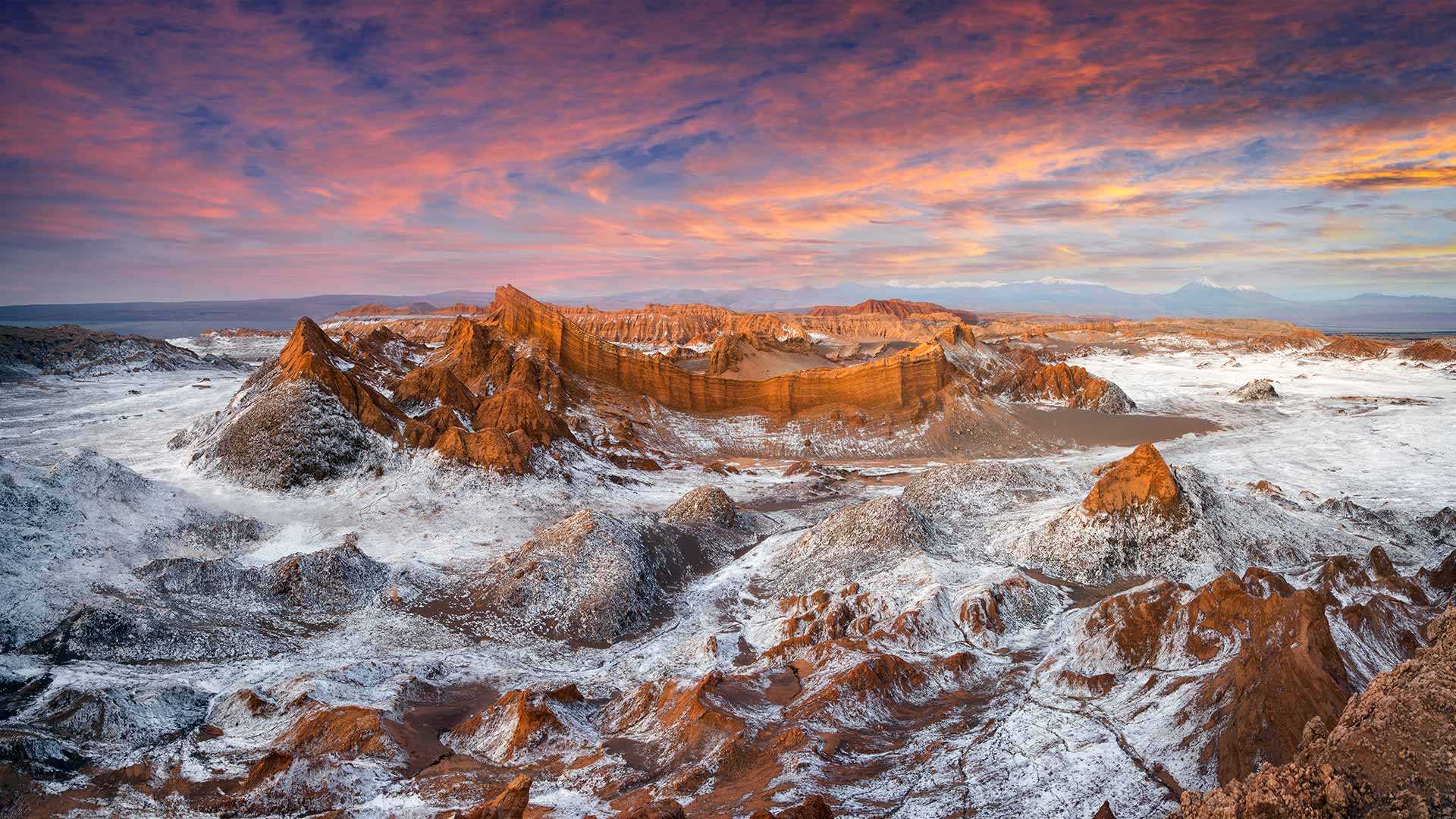
月亮谷位于智利北部的阿塔卡马沙漠,有着令人惊叹的美景。1982年,月亮谷被列为自然保护区,这是因为它拥有极吸引人的、未受破坏的原生环境和奇特的月球地形。关于月亮谷还有一个有趣的知识,那就是这片沙漠已经很多年未下过一滴雨了。
Achaches lookout, Valley of the Moon, Chile
El Valle de la Luna (Valley of the Moon) is located in the Atacama Desert of northern Chile. It has the most breathtaking view from the Achaches lookout. In 1982, Moon valley was declared a nature sanctuary for its stunning, untouched habitat and its peculiar lunar-like terrain. An interesting fact about the Valley of the Moon is that the desert hasn't received a single drop of rain in countless years.
死亡谷扎布里斯基角上空的银河,美国加利福尼亚州 The Milky Way over Zabriskie Point, Death Valley, California (© Matt Anderson Photography/Getty Images)
死亡谷扎布里斯基角上空的银河,美国加利福尼亚州 The Milky Way over Zabriskie Point, Death Valley, California (© Matt Anderson Photography/Getty Images)
布满星星的天空 A sky full of stars
扎布里斯基角上空的银河,加利福尼亚州
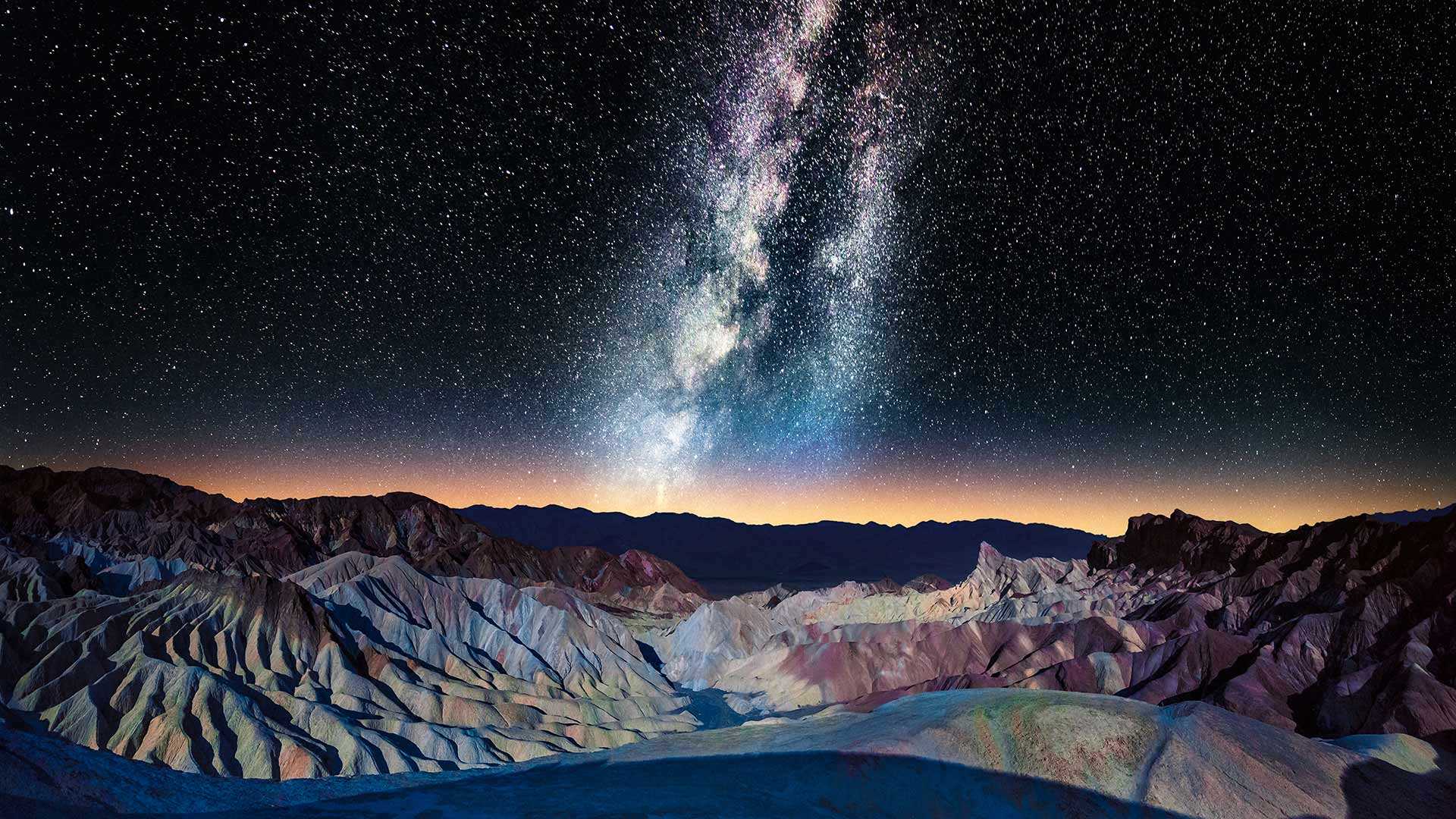
扎布里斯基角的标志性景观是摄影师和游客一年四季蜂拥而至的原因之一。大自然在这些荒地上侵蚀了亿万年,形成了这片令人惊叹的条纹岩层。这几座山峰上的深色部分是由古代火山爆发的熔岩形成的。扎布里斯基角位于加利福尼亚州的死亡谷国家公园,是无数电影(如《斯巴达克斯》和《星球大战》)的取景地。爱尔兰摇滚乐队U2的音乐专辑《约书亚树》的封面也在这里取景。难怪死亡谷暗夜节在美国如此受欢迎。
Milky Way over Zabriskie Point, California
The iconic view from Zabriskie Point is one of the reasons why photographers and tourists flock to this spot all year round. Weather and water carved out these badlands for eons, resulting in this stunning striped rock formation with an array of colors. The darker material on several peaks was formed by lava of an ancient volcanic eruption, making some of these ridges higher than others. Nestled in Death Valley National Park, California, Zabriskie Point has been the backdrop of countless movies like 'Spartacus' and 'Stars Wars.' The scenic overlook is featured on the cover of Irish rock band U2's album, 'The Joshua Tree.' It's no wonder the Death Valley Dark Skies Festival is a hugely popular event. Zabriskie Point was named after Christian Zabriskie, a distinguished member of the Pacific Coast Borax Company from 1885 to 1933.
埃庇道鲁斯剧场, 希腊阿尔戈利斯省 Ancient theater of Epidaurus in Argolis province, Greece (© George Pachantouris/Getty Images)
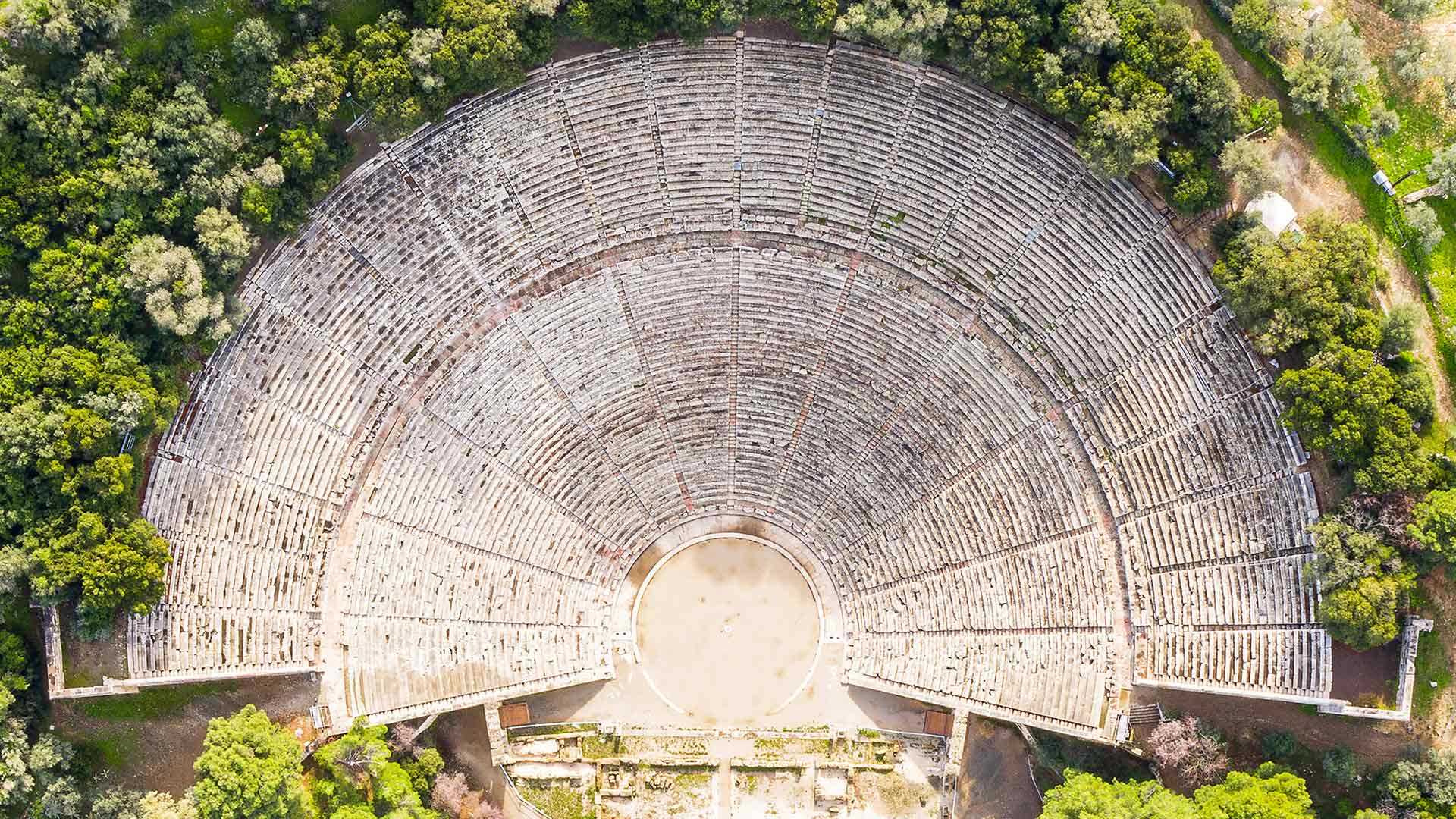
埃庇道鲁斯剧场, 希腊阿尔戈利斯省 Ancient theater of Epidaurus in Argolis province, Greece (© George Pachantouris/Getty Images)
声学杰作 Masterpiece of acoustic science
埃庇道鲁斯剧场,希腊
埃庇道鲁斯剧场隐藏在离雅典约100英里的埃庇道鲁斯山丘之中。它是一座保存完好的古希腊剧场,巨大的露天场地可以容纳超过14000名观众。这种希腊礼堂分三个部分,一是圆形主舞台,二是背景建筑,三是次第升高的观众席。埃庇道鲁斯剧场是一项工程壮举,它的建筑结构非常精妙,使剧场拥有完美的音响效果和良好的观赏效果。这座剧场原本是用于供奉古希腊医药之神阿斯克勒庇俄斯的。自1954年以来,该剧场上演了多位著名希腊演员和国际演员的戏剧和音乐表演。
Ancient theater of Epidaurus, Greece
Hidden in the hills of Epidaurus, about 100 miles from Athens, Greece, lies the ancient theater of Epidaurus. It's the embodiment of perfect classical proportions applied to the performing arts. A well-preserved Greek theater from ancient times, the massive open-air venue can hold more than 14,000 spectators. The three main features of the Greek auditoria are the orchestra, a circular space used as the main stage, the skene or stage building used as a backdrop, and lastly the cavea, or the auditorium, an ascending row of seats in a semi-circular shape. It is a feat of engineering built into the hillside with such precision that the theater has both perfect acoustics and an optimal structure for better viewing. The theater was dedicated to the Greek god of medicine, Asclepius. Since 1954, the theater has welcomed drama and music performances from several famous Greek and international actors.
下羚羊峡谷,亚利桑那州,美国 Lower Antelope Canyon near Page, Arizona (© AZCat/Getty Images)
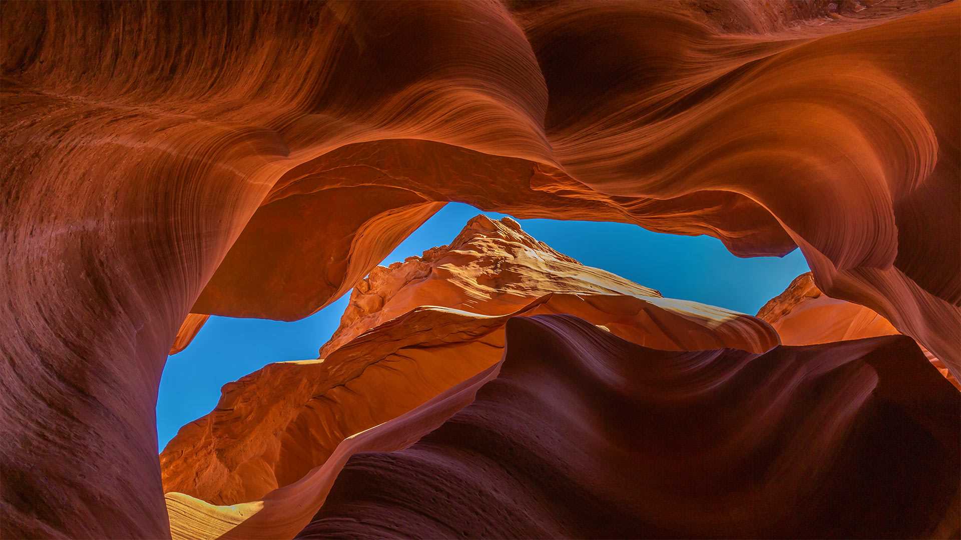
下羚羊峡谷,亚利桑那州,美国 Lower Antelope Canyon near Page, Arizona (© AZCat/Getty Images)
这些美丽的岩石波浪是什么? What are these beautiful sandy waves?
下羚羊峡谷,美国亚利桑那州
下羚羊峡谷是位于美国亚利桑纳州的一个美丽的自然景点。该峡谷也被原住民纳瓦霍人称为“螺旋石拱”。下羚羊峡谷不仅吸引了观景游客、徒步者,其鲜艳的色彩还吸引了许多摄影师。下羚羊峡谷呈“V”字形,这一独特的地貌是水流长年冲刷谷壁而形成的。羚羊峡谷的名字来源于纳瓦霍人的传说故事:过去,羚羊们会在冬天沿着峡谷漫步吃草。
Lower Antelope Canyon, Arizona
Lower Antelope Canyon is a beautiful natural tourist attraction located in Arizona. This canyon is also known as Hazdistazí (spiral rock arches) among the indigenous Navajo people. The canyon is not just a sight to behold and great for a hike, but with its beautiful hues is also a photographer's dream come true. The canyon is shaped like a 'V,' its unique geography created by water that rushed over its walls over many, many years. Antelope Canyon gets its name from Navajo stories regarding antelopes that grazed along the canyon in the wintertime.
Ureddplassen,挪威Helgelandskysten挪威风景线上的休息区 Ureddplassen, a rest area on the Helgelandskysten Norwegian Scenic Route, Norway (© Eyesite/Alamy)
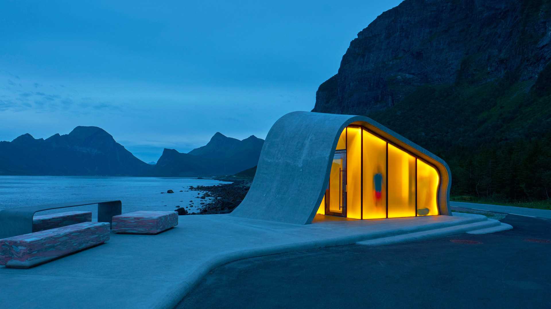
Ureddplassen,挪威Helgelandskysten挪威风景线上的休息区 Ureddplassen, a rest area on the Helgelandskysten Norwegian Scenic Route, Norway (© Eyesite/Alamy)
公共休息室还是旅游景点? A public restroom or a tourist spot?
Ureddplassen休息区,挪威
这里可以俯瞰峡湾、山脉和大海,这可能是世界上最好的休息场所之一。Ureddplassen休息区,也称为Uredd休息区,位于挪威Helgelandskysten国家风景公路的一段。Ureddplassen以其极简主义、未来主义的建筑和周围令人惊叹的景色为特色,提供了无与伦比的视觉体验。它有通向大海的大理石长椅和台阶,还有一个波浪形的公共卫生间,配有磨砂玻璃,在黑暗中亮得很漂亮。自揭幕以来,休息区迅速成为吸引当地人和游客的热门旅游目的地。在这里,他们还可以见证夏天午夜的太阳,在冬天饱览北极光。
Ureddplassen Rest Area, Norway
With sweeping views of fjords, mountains, and the sea, this is possibly one of the best places in the world to rest when you are on the road. Ureddplassen Rest Area, also known as Uredd Rest Area, is located on a section of the National Scenic Road Helgelandskysten in Norway. Characterized by its minimalist, futuristic architecture and breathtaking scenery all around, Ureddplassen offers a visual experience like no other. It has marble benches and steps leading out to the open sea, and a wave-shaped public restroom with frosted glass that lights up beautifully in the dark. Since its unveiling, the rest area has quickly become a popular tourist destination that draws in both locals and visitors. Here, they can also witness the midnight sun in the summer and feast their eyes on the northern lights in winter.
艾琳多南堡,苏格兰高地 (© VisualCommunications/Getty Images)

艾琳多南堡,苏格兰高地 (© VisualCommunications/Getty Images)
艾琳多南堡,苏格兰
艾琳多南堡坐落在苏格兰三个湖泊的交汇处,其宁静的表面下,是数个世纪的风云动荡。维京人、封建贵族和起义军来来去去,在这个苏格兰西部高地的湖滨城堡里留下了他们的足迹。
艾琳多南城堡始建于13世纪,用来防御维京人。后来,艾琳多南城堡经历了至少四次重建。中世纪时,这座城堡大部分时间都处于麦肯齐家族及其盟友马克雷家族的掌控下。1719年詹姆斯党人叛乱期间,艾琳多南城堡被英国皇家海军的炮弹摧毁,荒废了200年。
艾琳多南城堡位于杜伊奇湖、朗湖和阿尔什湖的交汇处。1911年,陆军中校约翰·麦克雷-吉尔斯特拉普买下它,用了20多年的时间重建城堡,并于1932年对外开放。重建时,城堡还新增了一座石桥,跨湖连接陆地,让城堡变得更加实用、美观和现代。现在,艾琳多南堡已成为苏格兰高地最受欢迎的景点之一,它的形象经常出现在包装和广告上。
拉布罗小镇,列蒂省,意大利 Village of Labro, Rieti Province, Italy (© Marco Ilari/Shutterstock)
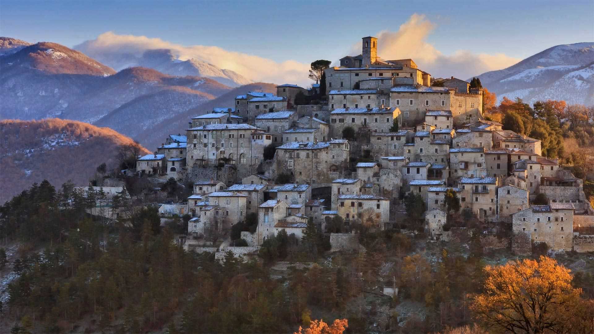
拉布罗小镇,列蒂省,意大利 Village of Labro, Rieti Province, Italy (© Marco Ilari/Shutterstock)
历史悠久的山顶村庄 History awaits atop the hill
拉布罗,意大利
今天的照片展示的是罗马东北方向约43英里的意大利小村庄拉布罗。拉布罗始建于公元9世纪至10世纪,罗马帝国奥托大帝将其封给了一个王室贵族,村庄面积只有约4.4平方英里。诺比利-维泰莱斯基城堡坐落在树木繁茂的山坡上,修建初衷是为了保卫周边和控制山谷的通信路线。二战期间,拉布罗的人口急剧减少,整个村庄几近消失。二战后,拉布罗以旅游业为目标进行了重建,现在这里是个热门的旅游目的地。
Village of Labro, Italy
Join us for a journey to a tiny Italian village about 43 miles northeast of Rome. Founded sometime between the 9th and 10th centuries, the village of Labro, having been assigned to a powerful aristocratic family by Emperor Otto the Great, only covers a little over 4.4 square miles. Perched atop a wooded hill, the Nobili-Vitelleschi castle originally served to secure the border and control communication routes in the valley below. Labro is now almost purely a tourist destination, having been restored for the purpose shortly after WWII when the village almost evaporated due to mass depopulation.
峡湾国家公园,新西兰南岛 Fiordland National Park in South Island, New Zealand (© WitR/Adobe Stock)
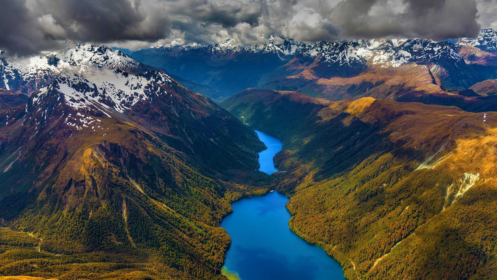
峡湾国家公园,新西兰南岛 Fiordland National Park in South Island, New Zealand (© WitR/Adobe Stock)
峡湾国家公园 When landscape met wilderness
怀唐伊日
每年的2月6日是怀唐伊日,这一天在所有新西兰人心中有着特殊的地位,因为这一天是新西兰的国庆节。1840年2月6日,40位毛利部落酋长和英国王室在怀唐伊签署了《怀唐伊条约》,建国新西兰。怀唐伊当地的庆典活动一早便开始了,有独特的雕刻比赛和文艺表演,营造出浓郁的节日气氛。
South Island, New Zealand
Waitangi Day holds a special place in all Kiwis' hearts as it is the day when New Zealand became a nation. It is celebrated every year on February 6, the date when the Treaty of Waitangi was signed in 1840 between 40 Māori chiefs and the British to make the nation of New Zealand. The founding document has inspired many to recognize the importance of cultural and political rights of the country, not just on this day, but every day. The festivities start typically early on the Waitangi Treaty Grounds, where celebrants take part in exceptional carving competitions and soak in the cultural performances to set the mood.