冰岛北部内陆景观中的Aldeyjarfoss瀑布 Aldeyjarfoss waterfall in northern Iceland's interior landscape (© Jim Patterson/Tandem Stills + Motion)
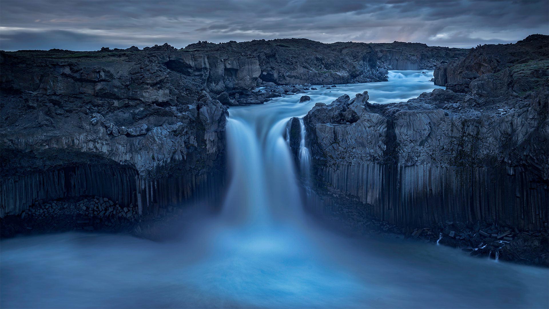
冰岛北部内陆景观中的Aldeyjarfoss瀑布 Aldeyjarfoss waterfall in northern Iceland's interior landscape (© Jim Patterson/Tandem Stills + Motion)
Behold the mighty Aldeyjarfoss
In waterfall-dense Iceland, it says something that Aldeyjarfoss is considered one of the most beautiful sights in the country. Fed by Iceland's largest ice cap, the 65-foot falls are flanked by distinctive hexagon-shaped basalt columns seemingly carved by some Norse god.
Okay, they may not have their origins with Odin's kin. Geologists will tell us that they're formed as lava flows cool and buckle under stress, with cracks penetrating deep into newly formed rock. The path of least resistance places these cracks at 120-degree intersections. So as cracks run deeper, their shape averages out to a near-perfect hexagon—exposing neatly geometric columns when the rock face eventually shears off.
看看强大的阿尔迪亚福斯
在瀑布密布的冰岛,阿尔迪亚尔福斯被认为是该国最美丽的景点之一。由冰岛最大的冰盖支撑,65英尺高的瀑布两侧是独特的六边形玄武岩柱,似乎是由一些挪威神雕刻而成。
好吧,他们可能不是奥丁的亲戚。地质学家会告诉我们,它们是在熔岩流冷却并在应力作用下弯曲时形成的,裂缝深入新形成的岩石。阻力最小的路径将这些裂缝放置在120度交叉处。因此,当裂缝越深,当岩石表面最终剪切时,它们的形状平均为接近完美的六边形,露出整齐的几何柱。
威尼斯海滩滑板公园鸟瞰图,洛杉矶 Aerial view of the Venice Skatepark in Venice Beach, Los Angeles (© Ingus Kruklitis/Getty Images)
威尼斯海滩滑板公园鸟瞰图,洛杉矶 Aerial view of the Venice Skatepark in Venice Beach, Los Angeles (© Ingus Kruklitis/Getty Images)
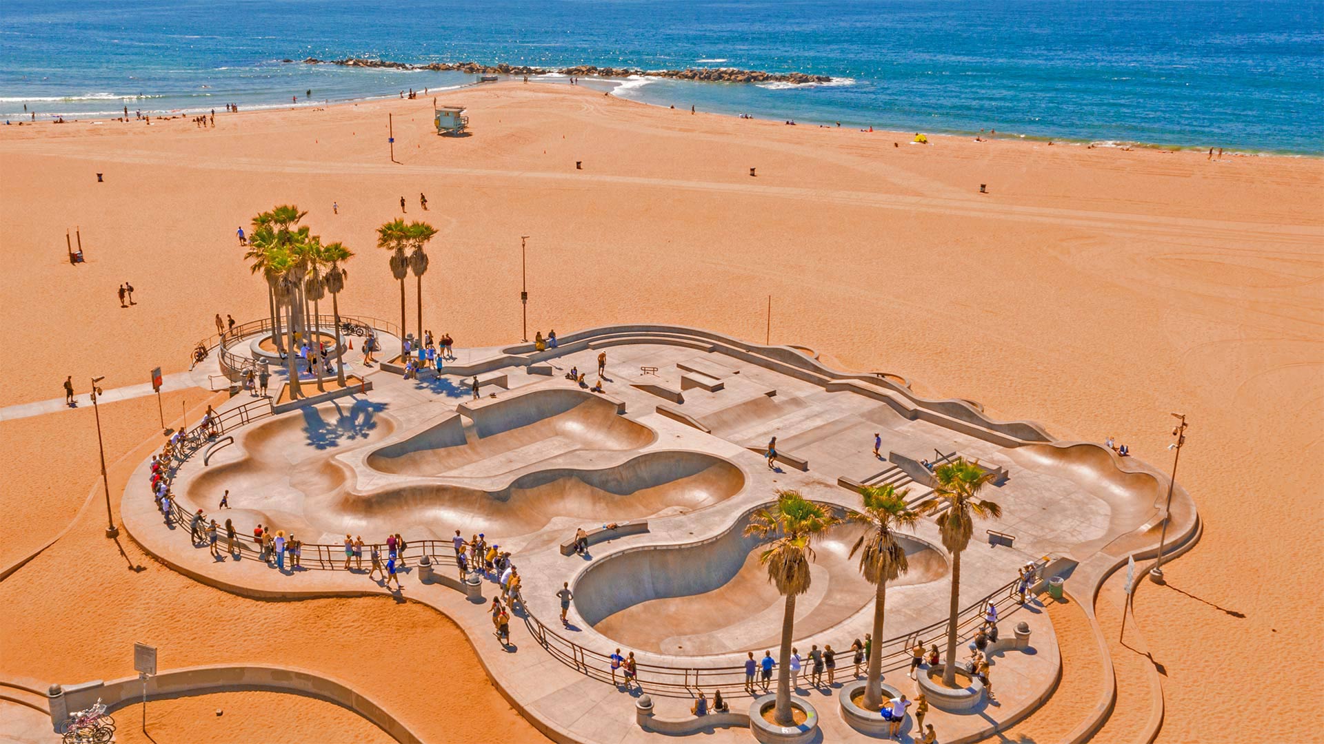
Sand, sun, and sk8ers
Walk the busy boardwalk of Venice Beach, in Los Angeles, and you'll see more sailing past than distant yachts—like an endless stream of skateboarders whizzing by within inches, always seeming to dodge you and your snow cone at the last second. Wanna bet they're headed to this world-famous skatepark right on the beach?
First poured in 2009 and serving locals, tourists, and pros alike ever since, Venice Skatepark's three bowls are usually brimming with skilled skaters—and visitors crowding the railings hoping to spy sick tricks. It's an appropriate setting for a top-notch skate spot: Bustling SoCal beaches like Venice were the birthplace of skateboarding, invented by bored surfers who wanted to cruise the land on days when waves were weak.
沙子、阳光和滑雪道
走在洛杉矶威尼斯海滩繁忙的木板路上,你会看到比远处的游艇更多的帆船驶过,就像无数的滑板运动员在几英寸之内呼啸而过,总是在最后一秒闪避你和你的雪球。想打赌他们会去海滩上这个世界著名的滑板公园吗?
威尼斯滑板公园的三个碗从2009年开始,为当地人、游客和专业人士提供服务。从那以后,威尼斯滑板公园的三个碗里通常挤满了熟练的滑板手和游客,他们挤满了栏杆,希望窥探恶心的把戏。这是一个适合顶级滑板场地的环境:像威尼斯这样熙熙攘攘的索卡尔海滩是滑板运动的发源地,滑板运动是无聊的冲浪者发明的,他们想在海浪弱的日子在陆地上冲浪。
德国图林根海尼克国家公园的树梢走道 Treetop walkway in Hainich National Park, Thuringia, Germany (© mauritius images GmbH/Alamy)
德国图林根海尼克国家公园的树梢走道 Treetop walkway in Hainich National Park, Thuringia, Germany (© mauritius images GmbH/Alamy)
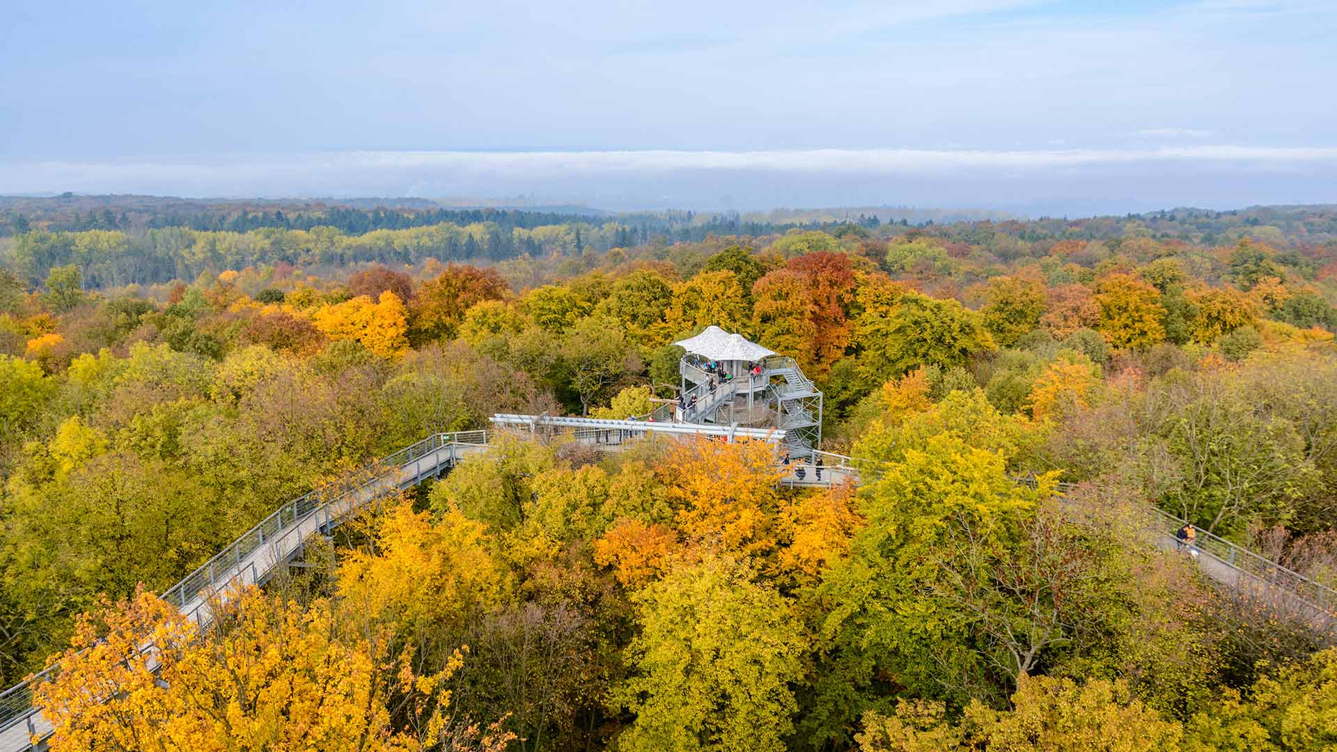
Top of the trees
There are 16 national parks in Germany, but Hainich National Park is the only one in the central state of Thuringia. One of the main objectives of this park is the protection of a native beech forest that is part of a UNESCO World Heritage listing. A treetop path allows visitors to enjoy a bird's eye view of the forest. The 530-meter-long wooden walkway winds along the tops of towering trees and spirals upwards to an observation tower. Along the walk, there is information about the park's flora and fauna – thousands of animal species live in the forest, including wildcats, bats, and woodpeckers.
树梢
德国有16个国家公园,但海尼克国家公园是中部图林根州唯一的国家公园。该公园的主要目标之一是保护作为联合国教科文组织世界遗产名录一部分的原生山毛榉林。树梢小径让游客可以鸟瞰森林。这条530米长的木制走道蜿蜒在参天大树的顶端,盘旋向上,形成了一座观景塔。沿着这条小路,有关于公园动植物的信息——森林里生活着数千种动物,包括野猫、蝙蝠和啄木鸟。
英国巴斯的埃文河 River Avon in Bath, England (© Robert Harding World Imagery/Offset by Shutterstock)
英国巴斯的埃文河 River Avon in Bath, England (© Robert Harding World Imagery/Offset by Shutterstock)
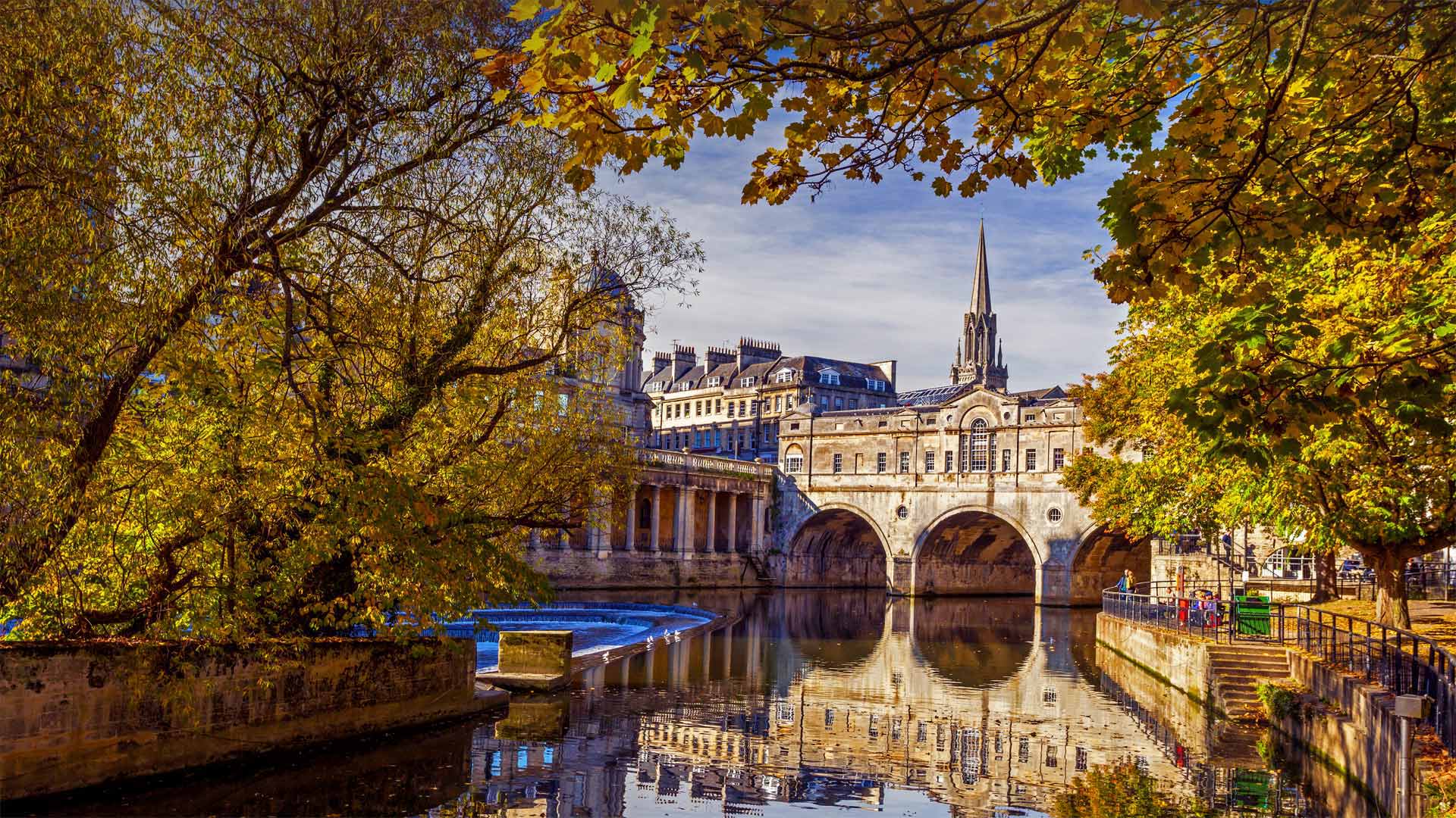
Celebrating all things Austen
Bath, in southwestern England, was the first home Jane Austen knew away from her tiny home village when she moved here at about age 25. Though the author only lived in Bath from 1801 to 1806 and did little writing here, no doubt this spa city on the River Avon gave her inspiration. After all, Bath was a popular resort at the time for Britain's upper crust—the posh, mannered society types whom Austen satirized so wittily in novels like 'Pride and Prejudice.'
The Jane Austen Festival kicks off here in town today and runs for 10 days, offering theatrical performances, walking and driving tours, a masked ball, and much more. Drawing thousands of fans each year, it's the largest and longest-running Austen event in the world.
庆祝一切,奥斯汀
英国西南部的巴斯是简·奥斯汀在25岁左右搬到这里时,第一个远离家乡的家。虽然作者从1801年到1806年只住在巴斯,在这里很少写作,但毫无疑问,这座位于埃文河畔的温泉城市给了她灵感。毕竟,巴斯在当时是英国上流社会人士的一个热门度假胜地,他们是奥斯汀在《傲慢与偏见》等小说中诙谐讽刺的时髦、有礼貌的社会类型
简·奥斯汀艺术节今天在这里开幕,为期10天,提供戏剧表演、步行和驾车旅行、蒙面舞会等等。每年吸引成千上万的粉丝,这是世界上规模最大、持续时间最长的奥斯汀盛会。
圣胡安群岛,华盛顿州 San Juan Islands, Washington (© Stephen Matera/Tandem Stills + Motion)
圣胡安群岛,华盛顿州 San Juan Islands, Washington (© Stephen Matera/Tandem Stills + Motion)
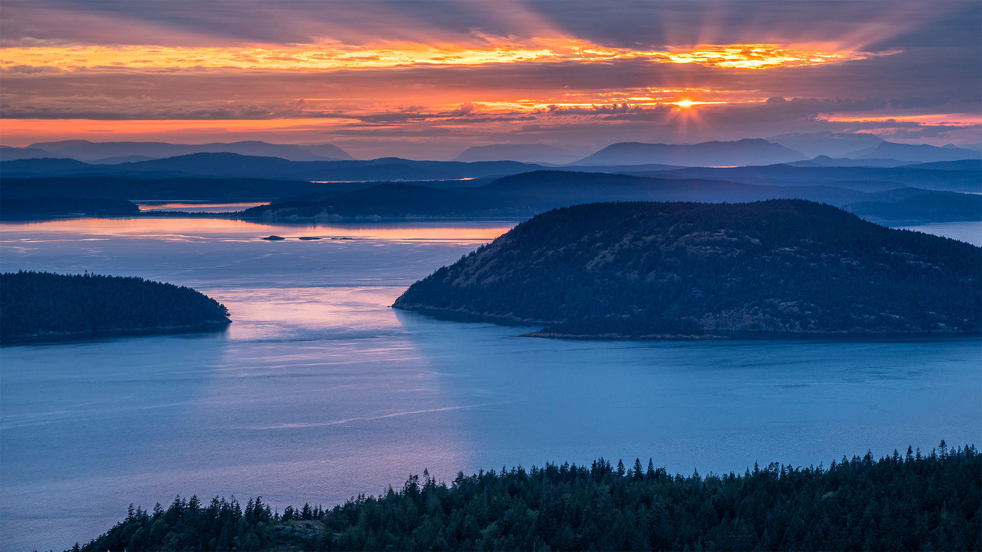
Islands of the Salish Sea
The San Juan archipelago is made up of over 400 islands and rocks, some only visible during low tide, in the Salish Sea between Washington state and Vancouver Island, British Columbia. No bridges connect the San Juans to the mainland, but four of the largest islands—San Juan, Orcas, Lopez, and Shaw—are accessible via the Washington State Ferries. Tourists come to the islands to take in the stunning coastal views, catch a glimpse of resident orcas, and partake in many outdoor activities, such as sea kayaking, biking, and hiking. One popular destination is the San Juan Island National Historical Park, which was established on September 9, 1966, to commemorate the Pig War. That strangely named confrontation between the US and the UK was sparked, in part, by the killing of a pig in 1859. But it was really a dispute over ownership of the islands.
萨利什海岛屿
圣胡安群岛由400多个岛屿和岩石组成,其中一些只有在退潮时才能看到,位于华盛顿州和不列颠哥伦比亚省温哥华岛之间的萨利什海。圣胡安岛与大陆之间没有桥梁连接,但圣胡安岛、奥卡斯岛、洛佩兹岛和肖岛四个最大的岛屿可以通过华盛顿州的渡轮到达。游客来到这些岛屿是为了欣赏美丽的海岸风光,欣赏当地的虎鲸,并参与许多户外活动,如海上皮划艇、骑自行车和徒步旅行。圣胡安岛国家历史公园(San Juan Island National Historical Park)是一个受欢迎的目的地,它建于1966年9月9日,是为了纪念猪战争。美英之间那场奇怪的对峙,部分是由1859年一头猪被杀引发的。但这确实是一场关于岛屿所有权的争端。
葡萄牙波尔图的莱洛书店 Livraria Lello in Porto, Portugal (© Nido Huebl/Shutterstock)
葡萄牙波尔图的莱洛书店 Livraria Lello in Porto, Portugal (© Nido Huebl/Shutterstock)
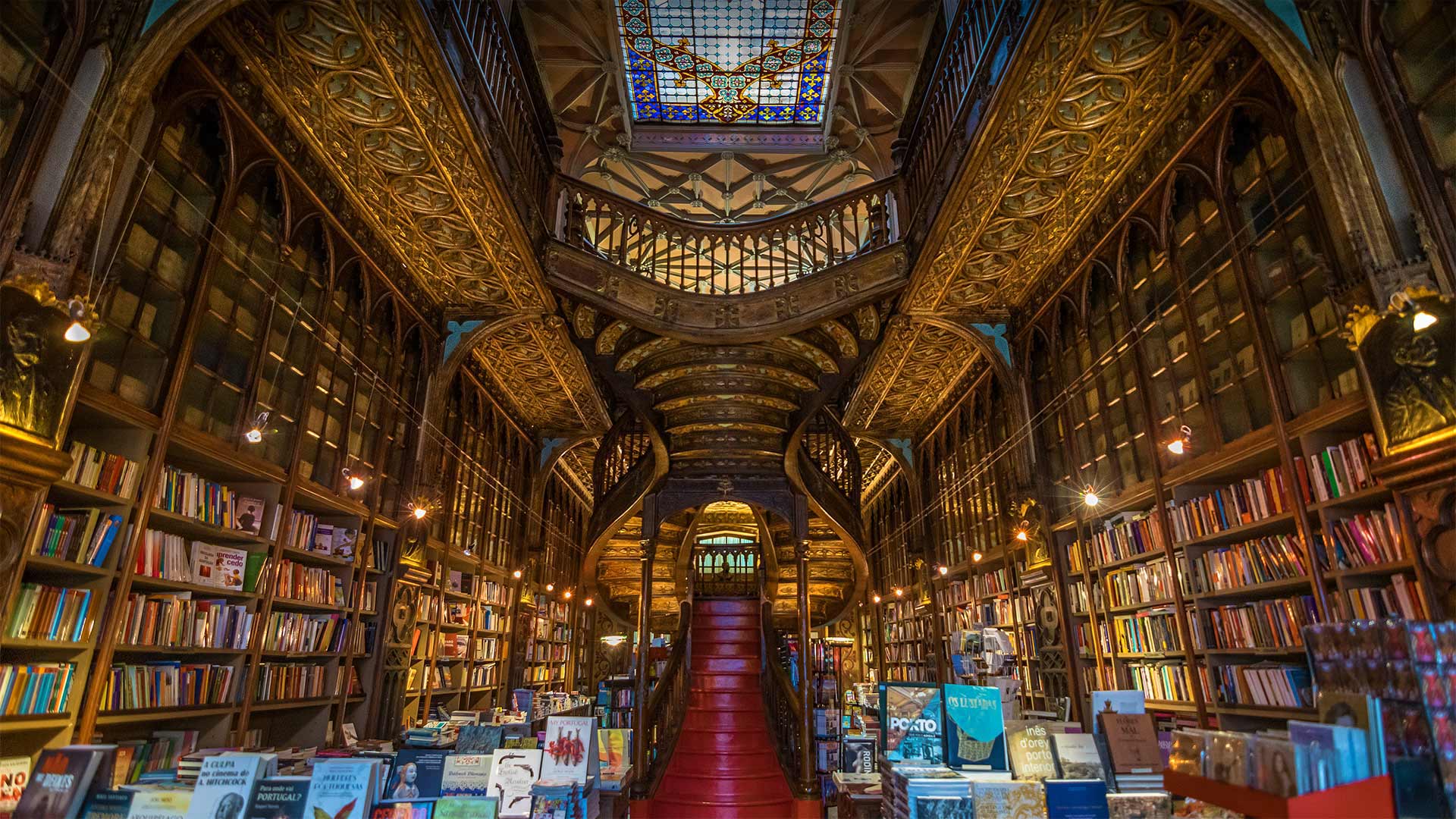
Enter the magical world of Livraria Lello
How will you celebrate International Literacy Day today? We're highlighting this important observance with a photo of a very special bookstore, Livraria Lello in Porto, Portugal. With its Art Nouveau façade, Neo-Gothic interior, stained-glass ceiling, swooping catwalks, and the dramatic, curvaceous staircase with crimson steps, the Lello is considered one of the most beautiful—and among the oldest—bookstores in the world. If rumors are true, the bookstore cast a spell on J.K. Rowling, inspiring scenery in 'Harry Potter,' such as the Hogwarts floating staircase and the Flourish and Blotts bookshop. (Rowling often visited the Lello when she lived in Porto in the early '90s.) The Lello bookstore opened in 1906 and has been serving up the magic of books ever since.
进入莱洛书店的魔法世界
你们今天将如何庆祝国际扫盲日?我们用葡萄牙波尔图一家非常特别的书店Livraria Lello的照片来强调这一重要的纪念活动。Lello书店拥有新艺术风格的外立面、新哥特式的内部、彩色玻璃天花板、俯冲的T型台和带有深红色台阶的戏剧性曲线美楼梯,被认为是世界上最美丽、最古老的书店之一。如果传闻属实,书店会对J.K.罗琳施下咒语,激发《哈利波特》中的灵感,比如霍格沃茨浮动楼梯和繁荣与布洛茨书店。(罗琳在90年代初住在波尔图时经常参观莱洛书店。)莱洛书店于1906年开业,从那时起就一直在提供书籍的魔力。
从昂沃峡湾眺望里欧岛,法国马赛 (© Jason Langley/AWL Images/Offset by Shutterstock)
约克郡谷地国家公园里的山丘,英格兰 Howgill Fells in the Yorkshire Dales National Park, England (© davidnmoorhouse/iStock/Getty Images Plus)
约克郡谷地国家公园里的山丘,英格兰 Howgill Fells in the Yorkshire Dales National Park, England (© davidnmoorhouse/iStock/Getty Images Plus)
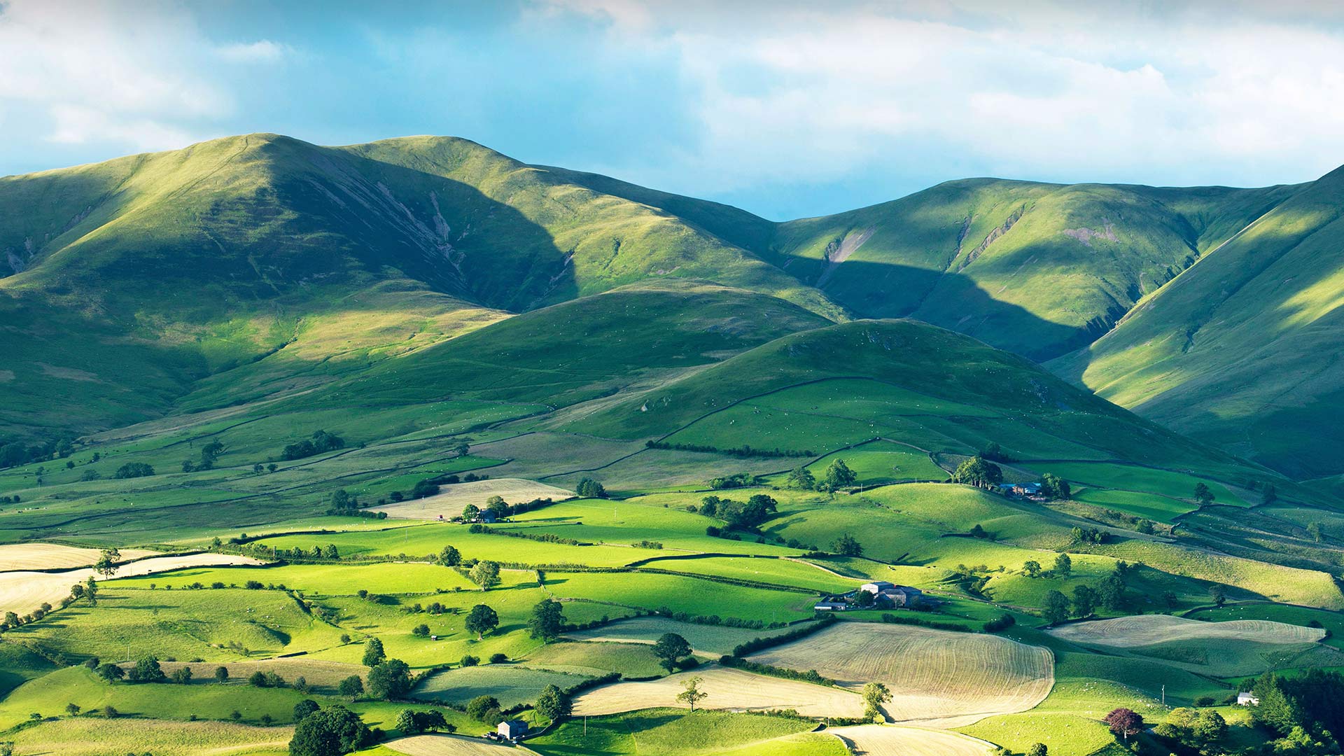
Between the Lakes and the Dales
Nestled between the Yorkshire Dales and the Lake District, the smooth rounded shapes and steep gills (ravines) of the Howgill Fells capture an eye-catching pattern of light and shade. These ancient hills, formed more than 400 million years ago, have remained a largely settlement-free zone, uncrossed by roads and untouched by development. Trees are scarce on the high ground, where sheep and wild ponies graze and small streams tumble down dark, narrow gullies and the panoramic views from the fells are a sight worth climbing for. The highest point is the top of The Calf, at 2,218ft (676m), from where hikers can enjoy a 20-mile skyline of the Lakeland peaks, the Yorkshire Three Peaks and the nearer Howgill peaks.
Part of the range sits within Yorkshire Dales National Park, although they are actually in the county of Cumbria. The Howgill Fells’ striking appearance was perhaps best summed up by the famed fell walker and guide book author A. Wainwright as “sleek and smooth, looking from a distance like velvet curtains in sunlight, like silken drapes at sunset … a remarkable concentration of summits often likened to a huddle of squatting elephants”.
湖与谷之间
坐落在约克郡山谷和湖区之间的豪吉尔森林,平滑的圆形和陡峭的鳃(沟壑)捕捉到了引人注目的明暗模式。这些形成于4亿多年前的古老山丘一直是一个基本上没有定居点的区域,没有道路交叉,也没有开发。高地上树木稀少,绵羊和野马在那里吃草,小溪从黑暗狭窄的沟壑中滚滚而下,从山林中俯瞰全景是一个值得攀登的景观。最高点是小牛的顶部,海拔2218英尺(676米),徒步旅行者可以在这里欣赏20英里的湖畔山峰、约克郡三峰和更近的豪吉尔峰的天际线。
部分山脉位于约克郡山谷国家公园内,尽管它们实际上位于坎布里亚县。豪吉尔·费尔斯引人注目的外表也许是著名的费尔沃克和导游书作者A的最佳概括。温赖特被称为“光滑光滑,从远处看,就像阳光下的天鹅绒窗帘,像日落时的丝绸窗帘……山峰的显著集中常常被比作一群蹲着的大象”。
在大运河上举办的赛船节, 意大利威尼斯 The Regata Storica on the Grand Canal in Venice, Italy (© Alexander Duffner/Alamy)
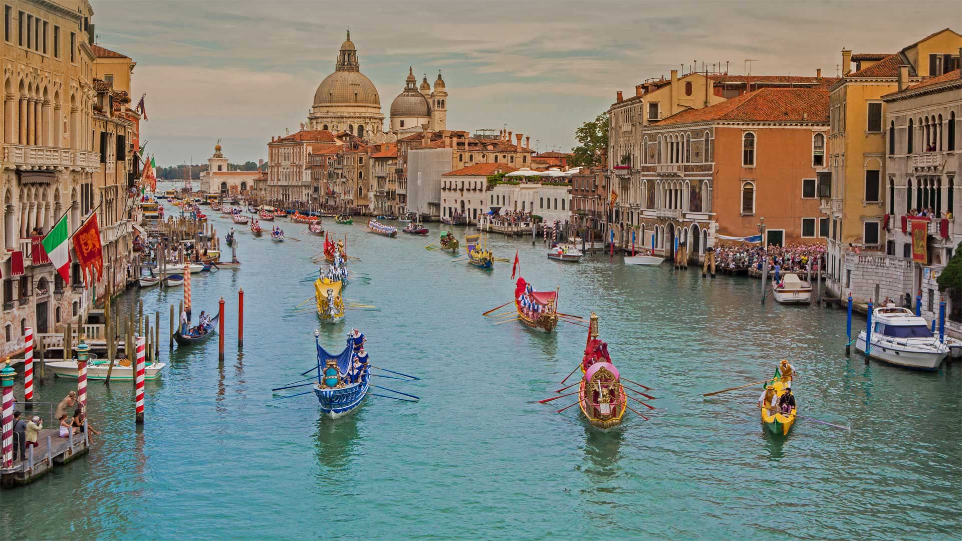
在大运河上举办的赛船节, 意大利威尼斯 The Regata Storica on the Grand Canal in Venice, Italy (© Alexander Duffner/Alamy)
Venice's grand regatta
Every year, on the first Sunday of September, Venice celebrates the Regata Storica along the city's most famous canal. The event is the highlight of the Venetian rowing calendar and consists of two parts: a historical boat parade and a series of rowing races. Festivities begin with a regal water pageant comprising a flotilla of colorful boats from the 16th century. Gondoliers are dressed in period costume as they ferry the Doge, his wife, and other high-ranking Venetian officials up the Grand Canal in a faithful recreation of Venice's storied maritime past. The regatta commemorates the welcome given in 1489 to Caterina Cornaro, the wife of the King of Cyprus, who renounced her throne in favor of Venice.
After the parade, it's time for the racing. Competitions are divided by age categories and feature different types of historical boats. The last and most popular race is the gondolini regatta. A lighter and faster version of the gondola from which it takes its shape, the gondolino is rowed by two oarsmen—standing as per Venetian tradition—who power their way up the Grand Canal toward the finish line at the famous 'machina,' the spectacular floating stage in front of the Ca' Foscari palace on the city's waterfront.
威尼斯大帆船赛
每年9月的第一个星期日,威尼斯都会沿着城市最著名的运河庆祝皇家历史。这项活动是威尼斯赛艇日历上的亮点,由两部分组成:历史性的划船游行和一系列赛艇比赛。庆祝活动以一个由16世纪的彩色船只组成的舰队组成的皇家水上盛会开始。吊船工人们穿着古装,将多格、他的妻子和其他威尼斯高级官员渡上大运河,忠实地再现威尼斯传奇的海上历史。这次帆船赛是为了纪念1489年塞浦路斯国王的妻子卡特琳娜·科纳罗(Caterina Cornaro)受到的欢迎,她放弃了王位,取而代之的是威尼斯。
游行结束后,是比赛的时间了。比赛按年龄分类,以不同类型的历史船只为特色。最后也是最受欢迎的比赛是贡多里尼赛船会。这是一种更轻、速度更快的平底船,由两名按照威尼斯传统站立的划手划船,他们沿着大运河向著名的“机器”(machina)终点前进,这是一个壮观的浮动舞台,位于城市海滨的卡福斯卡里宫(Ca’Foscari palace)前。
比斯蒂荒野上的“外星孵化场”,新墨西哥州 The 'Alien Egg Hatchery' in the Bisti/De-Na-Zin Wilderness, New Mexico (© Ian Shive/Tandem Stills + Motion)
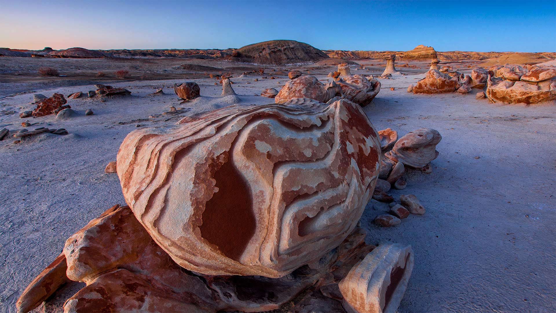
比斯蒂荒野上的“外星孵化场”,新墨西哥州 The 'Alien Egg Hatchery' in the Bisti/De-Na-Zin Wilderness, New Mexico (© Ian Shive/Tandem Stills + Motion)
Welcome to the 'Alien Egg Hatchery'
The otherworldly rock formations in the Bisti/De-Na-Zin Wilderness inspired some creative names—such as the 'Alien Egg Hatchery' seen in this photo. More than 70 million years ago, this desert was a tidal swamp along the shore of the long-evaporated Western Interior Seaway that once bisected North America. A diverse array of sediment and rock was deposited by the waters, and after the seaway retreated, the rocks remained.
Today, these inspiring desert landscapes are a protected area thanks to the Wilderness Act of 1964. If you're planning a road trip along any of New Mexico's Scenic Byways, make time for the Trails of the Ancients Byway, which will take you directly to Bisti/De-Na-Zin.
欢迎来到“外星人蛋孵化场”
在Bisti/De Na Zin荒野中,超凡脱俗的岩层激发了一些创造性的名字,如照片中的“外星人蛋孵化场”。7000多万年前,这片沙漠是一片潮汐沼泽,位于蒸发已久的西部内陆海道沿岸,曾经将北美一分为二。海水沉积了各种各样的沉积物和岩石,在海道后退后,岩石仍然存在。
如今,由于1964年的《荒野法案》,这些令人振奋的沙漠景观已成为保护区。如果你计划沿着新墨西哥州的任何一条风景优美的小路进行公路旅行,请腾出时间去参观古人的小路,这条小路将直接带你到比斯蒂/德纳津。