鸟瞰罗伊斯河上的教堂桥,瑞士卢塞恩 (© Neleman Initiative/Gallery Stock) Aerial view of Chapel Bridge over the river Reuss in Lucerne, Switzerland (© Neleman Initiative/Gallery Stock)
鸟瞰罗伊斯河上的教堂桥,瑞士卢塞恩 (© Neleman Initiative/Gallery Stock) Aerial view of Chapel Bridge over the river Reuss in Lucerne, Switzerland (© Neleman Initiative/Gallery Stock)
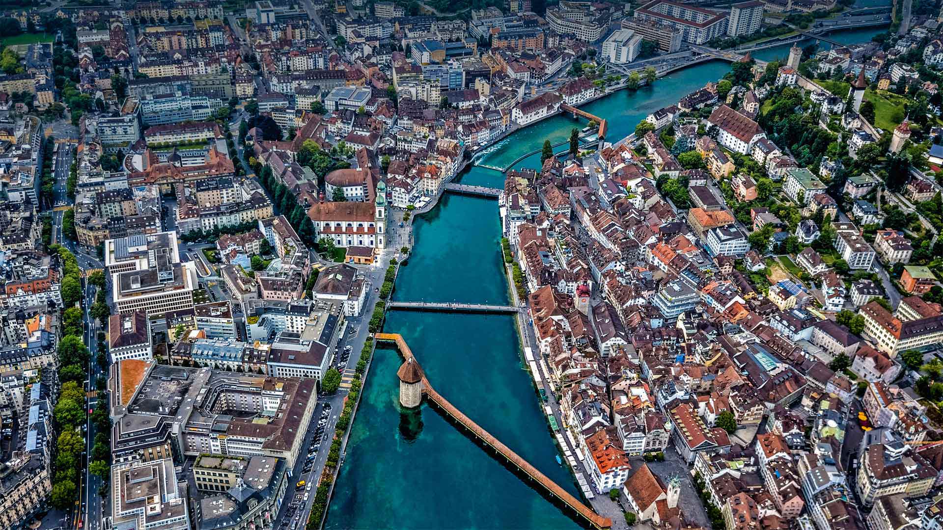
A Swiss city of bridges
We're in the heart of Switzerland looking down on the compact city of Lucerne, a charming waterfront setting along the shores of its namesake lake and the river Reuss. Surrounded by snow-capped mountains just out of frame, Lucerne lies in the Swiss-German speaking part of central Switzerland and is divided into two parts linked by a series of bridges. The most famous of these bridges—the centerpiece and symbol of Lucerne—is the Kapellbrücke (Chapel Bridge), a covered wooden footbridge which you can see spanning diagonally across the Reuss in our photo. The building rising from the river alongside the footbridge is a medieval water tower, which has been used as a prison, torture chamber, local archive, and treasury.
Originally built in 1333 as part of Lucerne's fortifications, Chapel Bridge connected the old town on the right bank of the Reuss to the new town on the left, securing the city from attack via Lake Lucerne to the south. It is believed to be the oldest covered wooden bridge in Europe, as well as the world's oldest surviving truss bridge, although much of it had to be replaced after a devastating fire in 1993. Named for the nearby St. Peter's Chapel—the oldest original church structure in Lucerne—Chapel Bridge is picturesque in more ways than one: There are dozens of interior paintings on triangular panels underneath the bridge's roof that date back to the 17th century. The paintings by local Catholic artist Hans Heinrich Wägmann depict historical events from the town, and despite the fire destroying most of the artwork, you can still admire some of the original paintings when crossing the river.
瑞士桥梁之城
我们在瑞士的中心,俯瞰着紧凑的城市卢塞恩,这是一个迷人的海滨城市,坐落在与之同名的湖和雷乌斯河沿岸。卢塞恩位于瑞士中部讲瑞士德语的地区,四周是刚出格的雪山,被一系列桥梁连接起来,分成两部分。这些桥中最著名的是卡佩尔布桥——卢塞恩的中心和象征ü教堂桥(Chapel Bridge),一座有盖的木制人行天桥,你可以在我们的照片中看到它斜跨在罗伊斯河上。沿着人行天桥从河里拔地而起的建筑是一座中世纪的水塔,它曾被用作监狱、刑讯室、地方档案馆和国库。
教堂桥始建于1333年,是卢塞恩防御工事的一部分,它连接了罗伊斯河右岸的老城和左岸的新城,通过卢塞恩湖向南保护城市免受攻击。它被认为是欧洲最古老的有盖木桥,也是世界上现存最古老的桁架桥,尽管在1993年的一场毁灭性的火灾后,大部分建筑不得不被替换。卢塞恩教堂桥最古老的原始教堂结构以附近的圣彼得教堂命名,但它在许多方面都如画如画:桥顶下的三角形面板上有几十幅室内画,可以追溯到17世纪。当地天主教艺术家汉斯·海因里希Wä格曼描绘了镇上的历史事件,尽管大火烧毁了大部分艺术品,但过河时你仍然可以欣赏到一些原作。
Nā pali海岸上的Bright Eye海蚀洞,夏威夷考艾岛 Bright Eye sea cave on the Nā Pali Coast, Kauai, Hawaii (© jimkruger/Getty Images)
Nā pali海岸上的Bright Eye海蚀洞,夏威夷考艾岛 Bright Eye sea cave on the Nā Pali Coast, Kauai, Hawaii (© jimkruger/Getty Images)
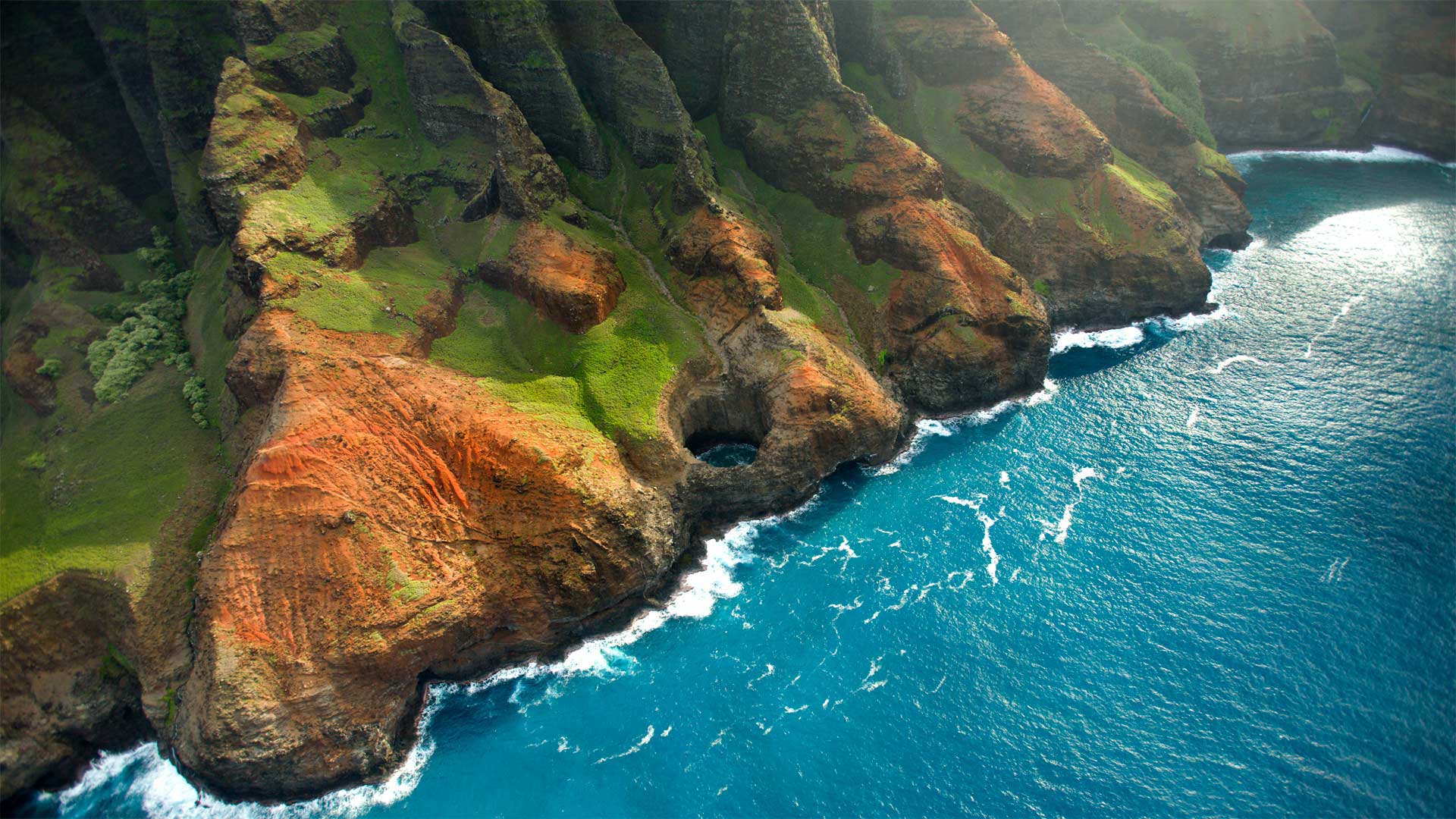
Just another day in paradise
It takes some effort to reach the stunning Nā Pali Coast on the Hawaiian island of Kauai. Located on the northwest side and stretching about 16 miles, Nā Pali isn't accessible by car. You have to hike in, fly in by helicopter, or come at it from the sea by boat. In the summer, when the waves are calm, you can explore the rugged coast by kayak, but you'll need a solid supply of muscle power for the sometimes-grueling paddle. If you seek a gentler approach—and if COVID restrictions allow—book a boat trip to explore the interiors of the sea caves that dot the shore. Today, we're looking down on the Bright Eye sea cave, one of several open-ceiling caves that lost their ceilings to the pounding of the sea.
又是天堂的一天
它需要一些努力,以达到惊人的Nā Pali夏威夷考艾岛的巴利海岸。位于西北侧,向北延伸约16英里Nā Pali岛不能开车去。你必须徒步旅行,乘直升飞机,或者乘船从海上来。在夏季,当海浪平静的时候,你可以用皮划艇探索崎岖的海岸,但是你需要一个坚实的肌肉力量来支撑有时会很费力的划桨。如果你寻求一个更温和的方法,如果科维德限制允许预订一个船旅行,探索内部的海洋洞穴点缀海岸。今天,我们俯瞰着明亮的眼睛海洞,它是几个开放式洞穴中的一个,因为海水的冲击而失去了它们的天花板。
鸟瞰皮纳图博火山湖和山脉,菲律宾波拉克 Aerial view of volcanic Lake Pinatubo and mountains, Porac, Philippines (© Amazing Aerial Agency/Offset by Shutterstock)
鸟瞰皮纳图博火山湖和山脉,菲律宾波拉克 Aerial view of volcanic Lake Pinatubo and mountains, Porac, Philippines (© Amazing Aerial Agency/Offset by Shutterstock)
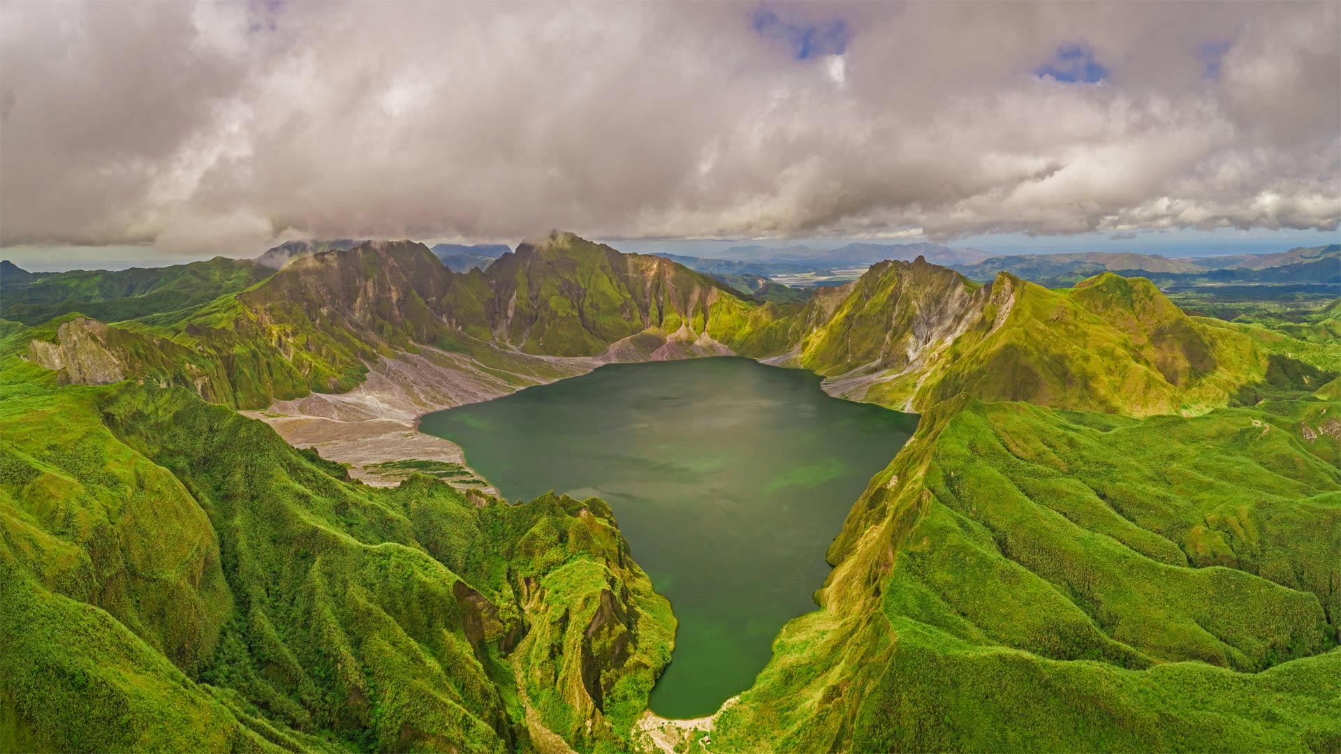
Are you older than this lake?
If you were born before summer 1991, the answer is yes. Sorry if you already felt a bit long in the tooth, but it's true: Before 30 years ago, Lake Pinatubo was just a rumble in Mount Pinatubo's magma-filled belly. It was a calamitous eruption on June 15, 1991—one of the 20th century's most powerful—that blew off Pinatubo's original summit and formed a vast crater, which gradually filled with water as greenery reclaimed the summit.
Located about 50 miles from the Philippines' capital of Manila, the crater was for many years a niche destination for hardy hikers, requiring days of travel to reach. More recently, a 4x4 road and tended hiking trail were added, reducing the rugged journey to a day trip.
你比这个湖大吗?
如果你出生在1991年夏天之前,答案是肯定的。抱歉,如果你已经觉得牙齿有点长了,但这是真的:30年前,皮纳图博湖只是皮纳图博火山充满岩浆的肚子里的隆隆声。这是1991年6月15日的一次灾难性喷发,是20世纪最强大的喷发之一,它把皮纳图博最初的山顶吹走,形成了一个巨大的火山口,随着绿色植物对山顶的再生,火山口逐渐充满了水。
这个陨石坑距离菲律宾首都马尼拉大约50英里,多年来一直是耐寒徒步旅行者的利基目的地,需要数天的旅行才能到达。最近,增加了一条4x4公路和徒步小径,将崎岖的旅程缩短为一日游。
加拿大亚伯达省贾斯珀国家公园马利尼湖的精神岛 Spirit Island in Maligne Lake, Jasper National Park, Alberta, Canada (© Jeff Penner/EyeEm/Getty Images)
Spirit Island in Maligne Lake, Jasper National Park, Alberta, Canada (© Jeff Penner/EyeEm/Getty Images)
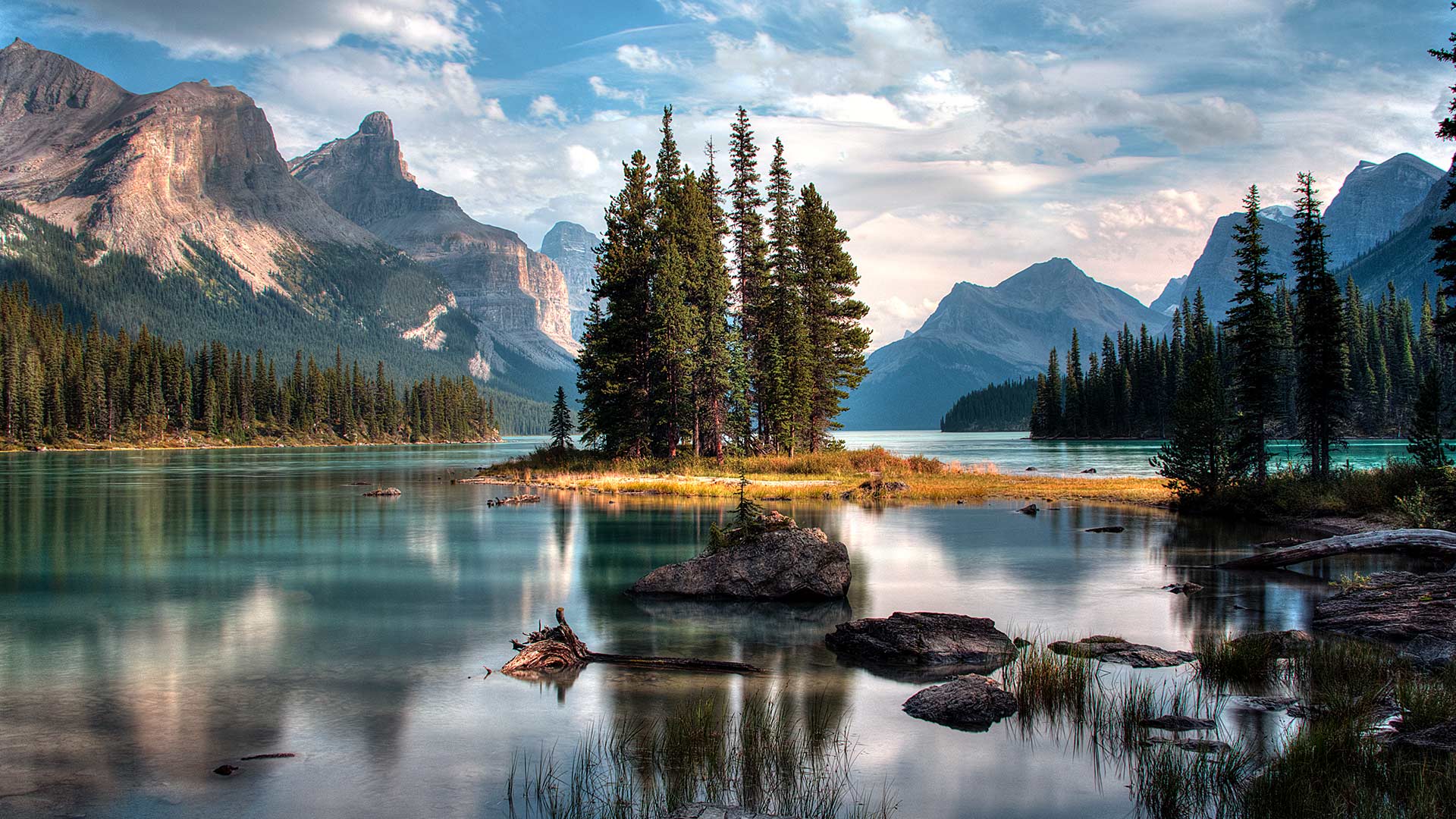
A photographer's paradise
If you are dreaming of an escape to paradise, look no further. Welcome to one of the most photographed sites in the majestic Canadian Rockies. Located in Jasper National Park in Alberta, the scenic Maligne Lake is 22 kilometres long, making it the largest natural lake out here. In the middle of this lake, sits the iconic Spirit Island which is only accessible via tour boats or private boats. The glacial, azure-blue waters, pine trees and snow-capped peaks frame Spirit Island, epitomizing the beauty of Jasper. In addition to admiring the natural beauty here, visitors can engage in activities such as hiking, fishing and kayaking during summer and skiing and snowshoeing in the winter.
摄影师的天堂
如果你梦想着逃往天堂,不要再看了。欢迎来到雄伟的加拿大落基山脉最受欢迎的景点之一。位于艾伯塔省贾斯珀国家公园,风景秀丽的马林湖长22公里,是这里最大的天然湖泊。在这个湖的中央,坐落着标志性的精神岛,只有通过旅游船或私人船只才能到达。冰川、湛蓝的海水、松树和白雪皑皑的山峰构成了精灵岛,是碧玉之美的缩影。除了欣赏这里的自然美景外,游客还可以在夏季进行徒步旅行、钓鱼和皮划艇活动,在冬季进行滑雪和雪鞋运动。
【端午安康】(© Shutterstock)
大弯国家公园中里奥格兰德河的景色,德克萨斯州 View of the Rio Grande River in Big Bend National Park, Texas (© Ian Shive/Tandem Stills + Motion)
大弯国家公园中里奥格兰德河的景色,德克萨斯州 View of the Rio Grande River in Big Bend National Park, Texas (© Ian Shive/Tandem Stills + Motion)
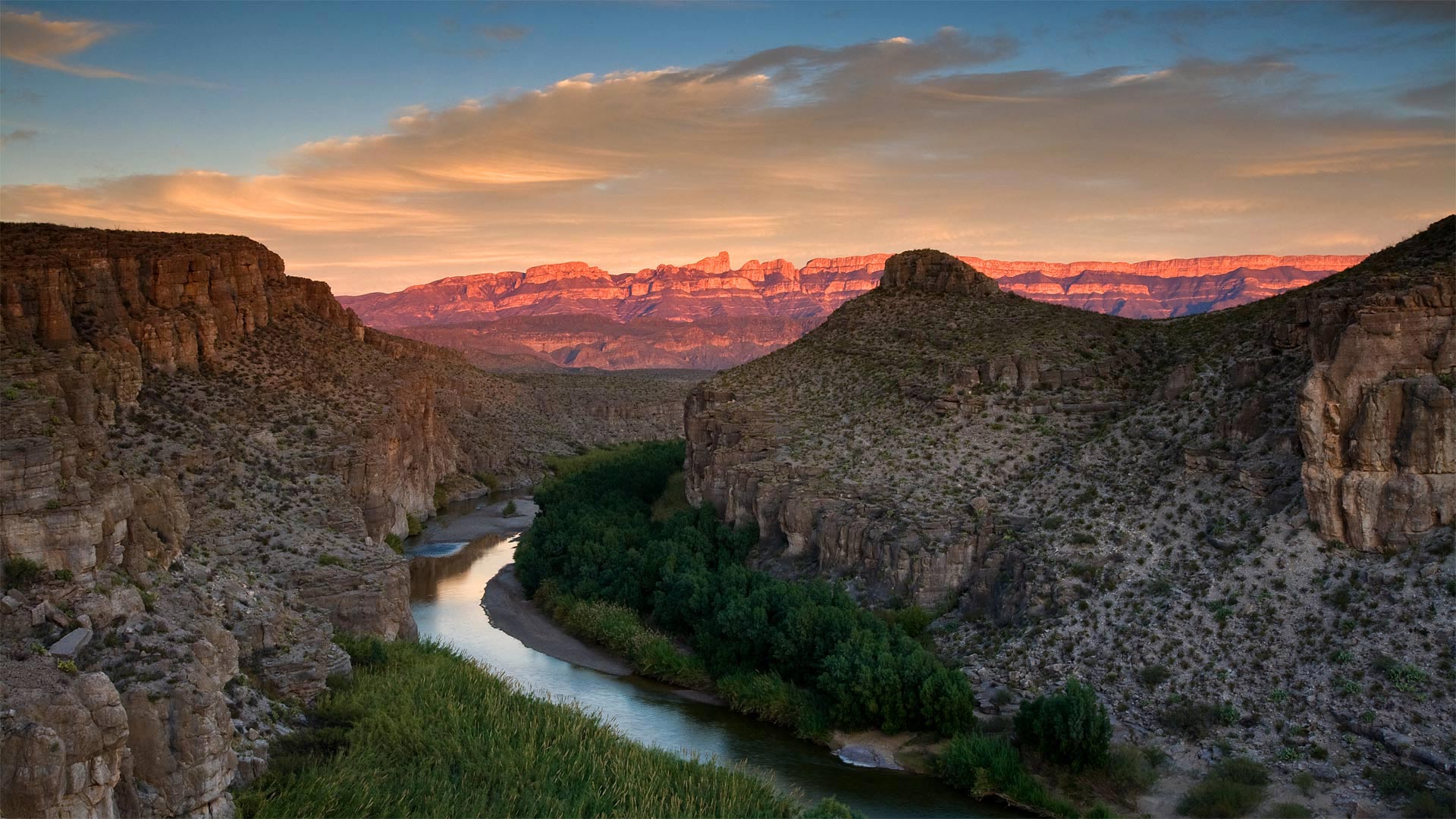
In Texas, even the riverbend is big
We're celebrating the 77th birthday of Big Bend National Park, the place the National Park Service calls 'one of the last remaining wild corners of the United States.' To get here, you have to be committed. This rugged terrain, which covers almost a million acres, is one of the most remote spots in the country—it's hours from the nearest towns or the closest airport, making it one of the least-visited national parks in the country. Those who do make the effort to get to Big Bend are rewarded with an undeveloped natural beauty, and silence, two things that seem to be in short supply these days.
At Big Bend you'll find craggy hiking trails, red mountain vistas, limestone canyons, and hot springs alongside the famous Rio Grande. There's also the wildlife you'd expect to find in the Wild, Wild West, including rattlesnakes, packs of javelinas, and 20 species of bats. But it's the huge night sky unencumbered by light pollution that draws stargazers to Big Bend from all over the world. After all, everything, as they say, is bigger in Texas.
在德克萨斯州,连河湾都很大
我们正在庆祝大弯国家公园77岁生日,国家公园管理局称之为“美国仅存的野生角落之一”。要到这里,你必须全力以赴。这片崎岖不平的土地占地近百万英亩,是美国最偏远的地区之一,距离最近的城镇或最近的机场只有几个小时的路程,使它成为美国游客最少的国家公园之一。那些努力到达大弯的人得到的回报是未开发的自然美景和沉默,这两样东西现在似乎供不应求。
在大弯,你会发现崎岖的徒步小径、红色的山景、石灰岩峡谷和著名的格兰德河旁的温泉。在野生的西部,你也会发现野生动物,包括响尾蛇,标枪和20种蝙蝠。但正是没有光污染的巨大夜空吸引着来自世界各地的天文爱好者来到大弯。毕竟,正如他们所说,德克萨斯的一切都更大。
格伦·埃蒂夫盛开着石南花的小湖,苏格兰 Small loch in Glen Etive, Scotland (© Oliver Hellowell/Minden Pictures)
格伦·埃蒂夫盛开着石南花的小湖,苏格兰 Small loch in Glen Etive, Scotland (© Oliver Hellowell/Minden Pictures)
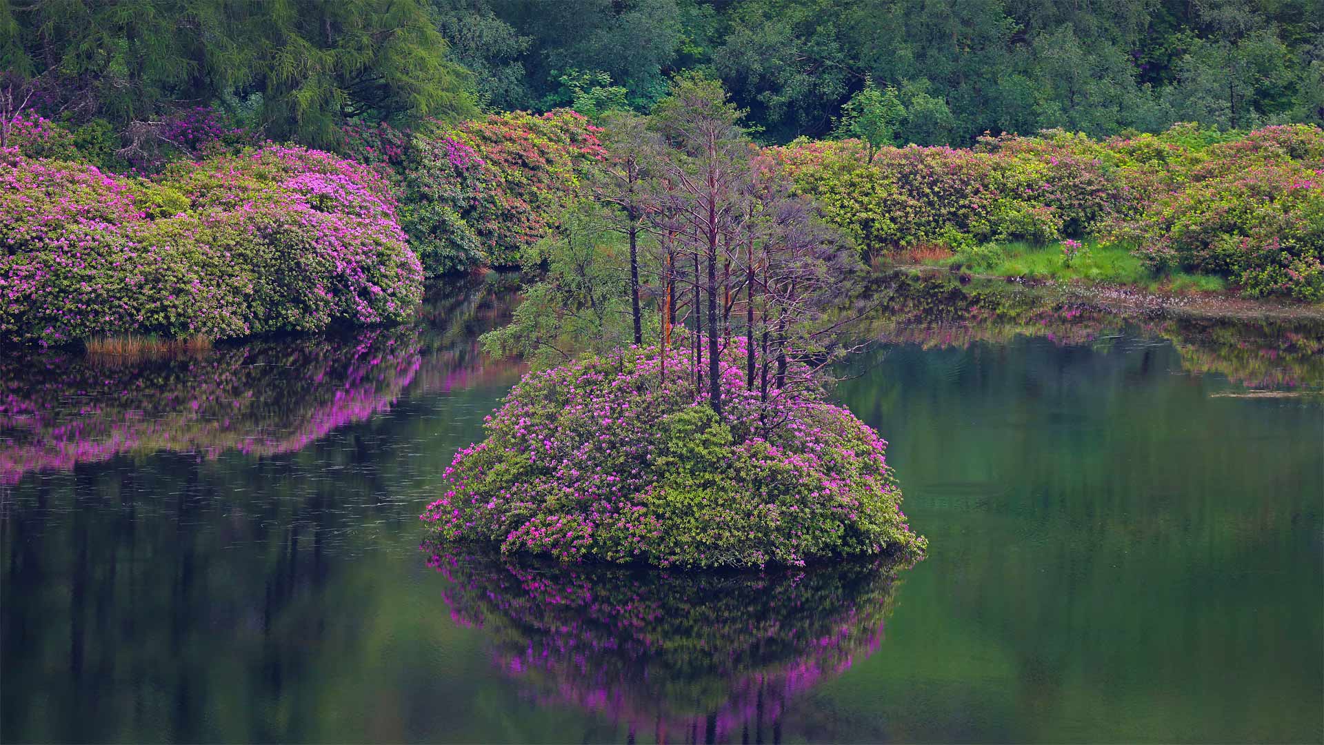
An island in the Highlands
Here in the Scottish Highlands, there's something about the rugged environs of Glen Etive that has tickled the imaginations of both ancient and modern storytellers. A glen is a long, narrow valley and this one is especially beautiful. It has strange footnotes in both Irish and Scottish folklore. The name itself translates to 'little fierce one' and is given in honor of Etive, the Gaelic goddess long associated with nearby Loch Etive.
According to an Irish myth, Glen Etive was founded by the tragic heroine Deirdre and her lover Naoise after they were forced into exile. In Scottish folklore, Glen Etive is said to be the home of a mythical creature called a Fachan--a giant cyclops with one leg, a single tuft of hair, and a lone hand protruding from its chest. Glen Etive has caught the attention of modern storytellers as well, drawn to its history and beautiful scenery. A surprising number of TV shows and major films, like 'Braveheart' and the James Bond installment 'Skyfall,' have shot on location here.
Glen Etive is also one of Scotland's 40 National Scenic Areas, and is a favorite destination for white water kayakers, who journey here to shoot down the series of rapids, falls, and pool drops along the River Etive. Hikers trek the mountain trails around Ben Starav to the southeast and the Glen Coe mountains in the north. Some of these of hikers are known as 'peak baggers,' who make it a game to summit every peak in the region. So far, about 4,000 or so people have completed the entire list of 284 Scottish peaks, or 'munros' as they're known locally.
高地上的一个岛屿
在苏格兰高地,格伦艾蒂夫崎岖的环境激发了古代和现代说书人的想象力。峡谷是一个又长又窄的山谷,这个山谷特别美丽。它在爱尔兰和苏格兰民间传说中都有奇怪的脚注。这个名字本身翻译成“小凶猛的一个”,是为了纪念艾蒂芙,长期以来与附近的艾蒂芙湖联系在一起的盖尔女神。
根据一个爱尔兰神话,格伦·艾蒂夫是由悲剧女主角迪尔德雷和她的情人娜奥伊丝在被迫流亡后建立的。在苏格兰民间传说中,格伦埃蒂夫据说是一种神话生物法坎的家——一只巨大的独眼巨人,一条腿,一簇头发,一只手从胸前伸出。格伦艾蒂夫吸引了现代说书人的注意,也被它的历史和美丽的风景所吸引。很多电视节目和主要电影,如《勇敢的心》和詹姆斯·邦德的《天崩地裂》都在这里拍摄。
格伦艾蒂夫也是苏格兰40个国家级风景区之一,也是白水皮划艇运动员最喜欢的目的地,他们在这里沿着艾蒂夫河击落一系列急流、瀑布和池水。徒步旅行者沿着本斯塔拉夫周围的山路跋涉到东南部和北部的格伦科山脉。其中一些徒步旅行者被称为“峰袋客”,他们把登上该地区的每一座山峰当作游戏。到目前为止,大约有4000人已经完成了284座苏格兰山峰的完整列表,也就是当地人所熟知的“munros”。
2012年5月20日新墨西哥上空的日环食 Annular eclipse over New Mexico, May 20, 2012 (© ssucsy/Getty Images)

2012年5月20日新墨西哥上空的日环食 Annular eclipse over New Mexico, May 20, 2012 (© ssucsy/Getty Images)
Ring of fire
No, this isn't some kind of early promo for 'Halo: Infinite.' Today's homepage image shows an annular solar eclipse captured in New Mexico in 2012. ('Annular' is just a fancy word for doughnut-shaped.) It's not unlike the eclipse some northerly parts of the world will enjoy today.
Annular eclipses like today's occur when the moon is at its apogee, or the furthest distance in its orbit from Earth. Since the moon looks its smallest to us now, it can't fully cover the sun—but the lucky few living in far northern Canada, Scandinavia, and Siberia will have tickets to a one-ring solar circus once everything lines up just right.
火环
不,这不是“光环:无限”的早期宣传。今天的主页图片显示了2012年在新墨西哥州拍摄的一次日环食。(“日环食”只是甜甜圈形状的一个花哨的词。)这和今天世界上一些偏北地区将享受的日食没什么不同。
像今天这样的环食发生在月球的最远点,或者说是其轨道上离地球最远的地方。由于月球现在看起来是最小的,它不能完全遮住太阳,但生活在遥远的加拿大北部、斯堪的纳维亚半岛和西伯利亚的少数幸运儿,一旦一切都安排得恰到好处,就会有单圈太阳马戏团的票。
埃尔瓦什附近的格拉萨圣母堡,葡萄牙 Nossa Senhora da Graça Fort near Elvas, Portugal (© Luis Pina Photography/Shutterstock)
埃尔瓦什附近的格拉萨圣母堡,葡萄牙 Nossa Senhora da Graça Fort near Elvas, Portugal (© Luis Pina Photography/Shutterstock)
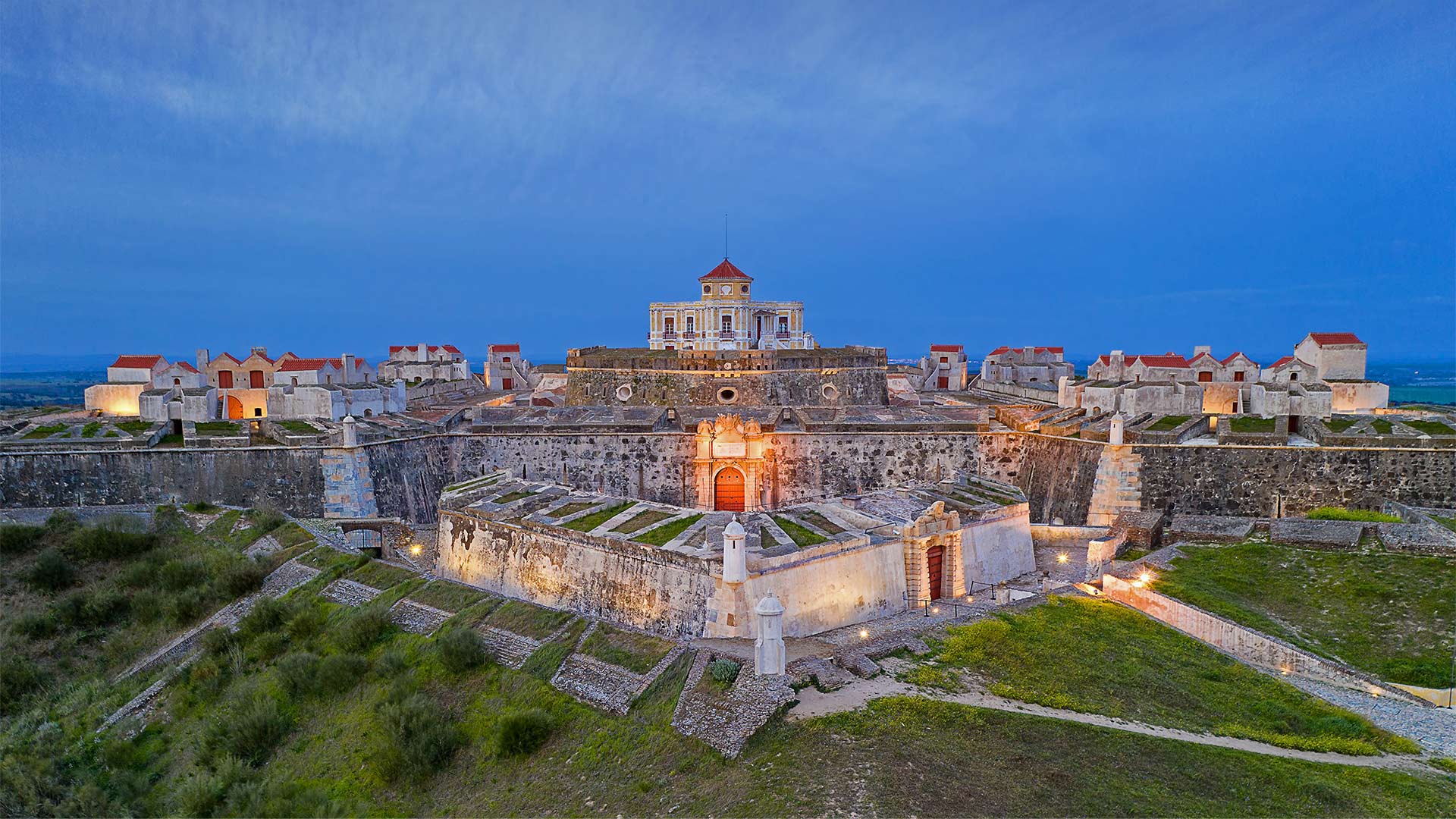
A Portuguese fort takes a star turn
Perched on a strategic hillside, high above the hot, dry plains of eastern Portugal, the Nossa Senhora da Graça Fort has been called a masterpiece of 18th-century military architecture. The thick wall that surrounds the fortress are shaped in a star pattern, with pentagonal bastions jutting out from the curtain wall at the corners. We're looking at one of those bastions in the center of our image.
A stone's throw from the Spanish border, the Nossa Senhora da Graça Fort was built to defend the garrison border town of Elvas. It's a region shaped by war. The Spanish laid siege to the area during the Portuguese Restoration War (1640-1668), but after the Nossa Senhora da Graça Fort was built a century later, the town was never defeated. With its 144 cannons, the fort resisted an attack by another wave of Spanish forces during the 1801 War of the Oranges and 10 years later drove back an invading French army during the Peninsular War.
Eventually the fort became a political prison, which it remained until 1974, when it was abandoned and fell into ruin. But it was restored after 2012, when UNESCO recognized the entire historical center of Elvas—including the Nossa Senhora da Graça Fort, a few other nearby forts, and the 16th-century Amoreira Aqueduct—as a World Heritage Site.
葡萄牙要塞有一个星形转弯
坐落在战略山坡上,高出葡萄牙东部炎热干燥的平原,Nossa Senhora da Graç堡垒被称为18世纪军事建筑的杰作。围绕堡垒的厚墙呈星形,五角形堡垒从墙角的幕墙中伸出。我们看到的是图像中心的一个堡垒。
离西班牙边境只有一箭之遥,Nossa Senhora da Graç一座堡垒是为了保卫守军边境城镇埃尔瓦斯而建的。这是一个战争形成的地区。在葡萄牙复辟战争(1640-1668)期间,西班牙人包围了该地区,但在诺萨塞诺拉大格拉之后ç一个世纪后建了一座堡垒,这个城镇从未被打败。在1801年的橘子战争中,这座拥有144门大炮的堡垒抵抗了西班牙军队的另一波进攻,10年后在半岛战争中击退了入侵的法国军队。
最终,这座堡垒变成了一座政治监狱,一直保留到1974年,当时它被遗弃并陷入废墟。但在2012年联合国教科文组织承认整个埃尔瓦斯历史中心,包括诺萨塞诺拉达格拉之后,它被修复了ç一个堡垒,附近的其他几个堡垒,以及16世纪的阿莫雷拉渡槽作为世界遗产。
加利福尼亚湾中数千条杰克鱼成群游动,墨西哥普尔莫角国家公园 Thousands of jack fish swimming together at Cabo Pulmo National Park, Sea of Cortez, Baja California, Mexico (© Christian Vizl/Tandem Stills + Motion)
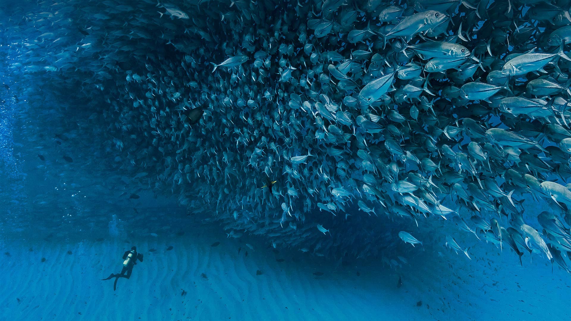
加利福尼亚湾中数千条杰克鱼成群游动,墨西哥普尔莫角国家公园 Thousands of jack fish swimming together at Cabo Pulmo National Park, Sea of Cortez, Baja California, Mexico (© Christian Vizl/Tandem Stills + Motion)
A day for our oceans
To celebrate World Oceans Day, we're swimming through a shoal of jack fish just off the coast of Baja, California, in Cabo Pulmo National Park. This Mexican marine park in the Sea of Cortez is home to the northernmost and oldest coral reef on the west coast of North America, estimated to be about 20,000 years old. Jacks are clearly plentiful here, but divers and snorkelers in Cabo Pulmo can also come across many other species of fish and marine mammals, including many varieties of sharks, whales, dolphins, tortoises, and manta rays.
For this year's World Oceans Day, the UN chose the theme 'The Ocean: Life & Livelihoods,' to raise awareness of the nearly 3 billion people worldwide who depend on oceans for their food and way of life. The residents of Cabo Pulmo know a little about this—to help revitalize their previously unprotected and overfished waters, the Mexican government turned Cabo Pulmo into a national park in 1995. But more controversially, they also banned fishing, a big deal in an area where many residents lived off the food they caught by hand. The preservation efforts paid off, though—researchers say the park experienced a 460% increase in the number of fish living in park waters between 1999 and 2009, turning Cabo Pulmo one of the world's most robust marine reserves. Now, many residents who once relied on fishing have been able to move into jobs in ecotourism or other vocations supporting the park.
海洋的一天
为了庆祝世界海洋日,我们正在加利福尼亚州巴哈海岸附近的卡波普尔莫国家公园游泳。这座位于科尔特斯海的墨西哥海洋公园是北美洲西海岸最北、最古老的珊瑚礁的所在地,据估计大约有2万年的历史。杰克在这里显然很丰富,但在卡波普尔莫潜水员和潜水者也可以遇到许多其他种类的鱼类和海洋哺乳动物,包括许多种类的鲨鱼、鲸鱼、海豚、乌龟和蝠鲼。
今年的世界海洋日,联合国选择了“海洋:生命与生计”这一主题,以提高全世界近30亿以海洋为食物和生活方式的人们的认识。卡波普尔莫的居民对此略知一二,为了帮助恢复他们以前未受保护和过度捕捞的水域,墨西哥政府在1995年将卡波普尔莫变成了一个国家公园。但更具争议的是,他们还禁止捕鱼,这在一个许多居民靠手工捕捞的食物为生的地区是一件大事。保护工作取得了成效,不过研究人员说,1999年至2009年间,公园水域的鱼类数量增加了460%,使卡波普尔莫成为世界上最强大的海洋保护区之一。现在,许多曾经依赖捕鱼的居民已经能够从事生态旅游或其他支持公园的职业。