标签 城堡 下的文章
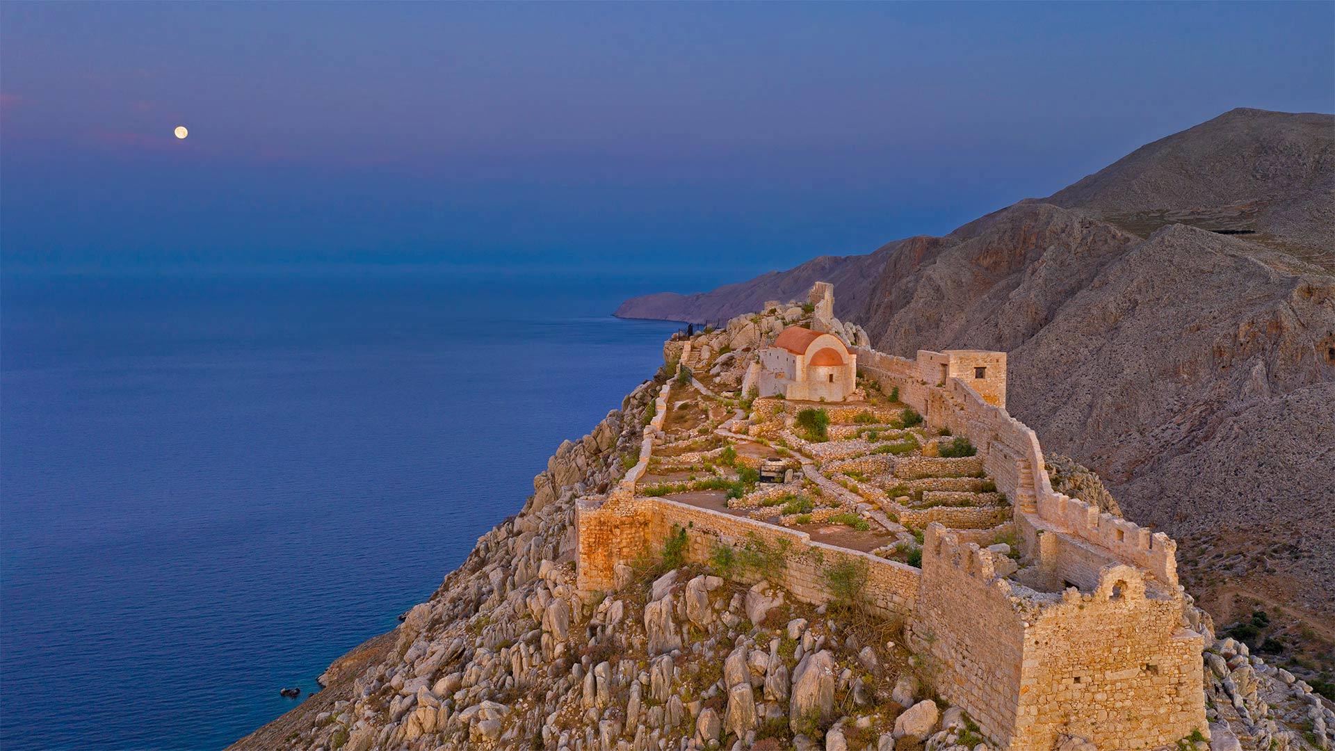
哈尔基岛的圣约翰骑士中世纪城堡遗址,希腊 Ruins of the medieval castle of the Knights of St. John above the village of Chorio, Halki Island, Greece (© Massimo Ripani/eStock Photo)
哈尔基岛的圣约翰骑士中世纪城堡遗址,希腊 Ruins of the medieval castle of the Knights of St. John above the village of Chorio, Halki Island, Greece (© Massimo Ripani/eStock Photo)
爱琴海之巅 High above the Aegean Sea
希腊哈尔基岛上的城堡废墟
哈尔基是爱琴海中的一个希腊小岛,当你需要逃离时,你会去那里。在人迹罕至的道路上,当其他希腊岛屿挤满游客时,哈尔基安静而困倦。到达目的地的唯一途径是从大得多的罗德岛乘坐渡轮。哈尔基岛的总面积只有1100平方英里,是多德卡内塞群岛中最小的有人居住的岛屿。
哈尔基岛上最受欢迎的景点之一是这座中世纪城堡的废墟,该城堡由圣约翰骑士团于14世纪在岛上朝南的海岸上现已废弃的乔里奥村建造。从岛上唯一的城镇恩波里奥港口村出发,步行很短,很上坡,岛上数百名常住居民大多住在这里。20世纪中叶,有相当一部分人口离开,其中许多人定居在墨西哥湾沿岸的佛罗里达州塔蓬斯普林斯镇,该镇号称拥有美国所有城市中最高比例的希腊裔美国人。来自哈尔基和其他希腊岛屿的人们被引诱到塔蓬泉从事海绵潜水员的工作,这是他们在希腊世代磨练的技能。这些天,哈尔基除了吃饭、放松和游泳外,没有什么其他活动。像所有希腊岛屿一样,哈尔基有美丽的海滩。在这里,你更有可能把它们都留给自己。
Castle ruins on the island of Halki, Greece
Halki, a tiny Greek island in the Aegean Sea, is the type of place you go to when you need a getaway from your getaway. Off the beaten path, Halki is quiet and sleepy when other Greek islands are flush with visitors. The only way to arrive is by ferry from the much larger island of Rhodes. Halki has a total area of just 11, sun-kissed square miles, the smallest inhabited island in the Dodecanese island group.
One of the most popular attractions on Halki is the ruins of this medieval castle built by the Knights of St. John in the 14th century in the now abandoned village of Chorio on the island's south-facing shore. It's a short, uphill walk from the only town on the island, the port village of Emporio, where most of the island's few hundred permanent residents live. A significant portion of the population left in the mid-20th century, many of them settling in the Gulf Coast town of Tarpon Springs, Florida, which lays claim to having the highest percentage of Greek Americans of any US city. People from Halki and other Greek islands were lured to Tarpon Springs to work as sponge divers, a skill they honed for generations in Greece. These days, not much goes on in Halki beyond eating, relaxing, and swimming. Like all Greek islands, Halki has beautiful beaches. Here, you're more likely to have them all to yourself.
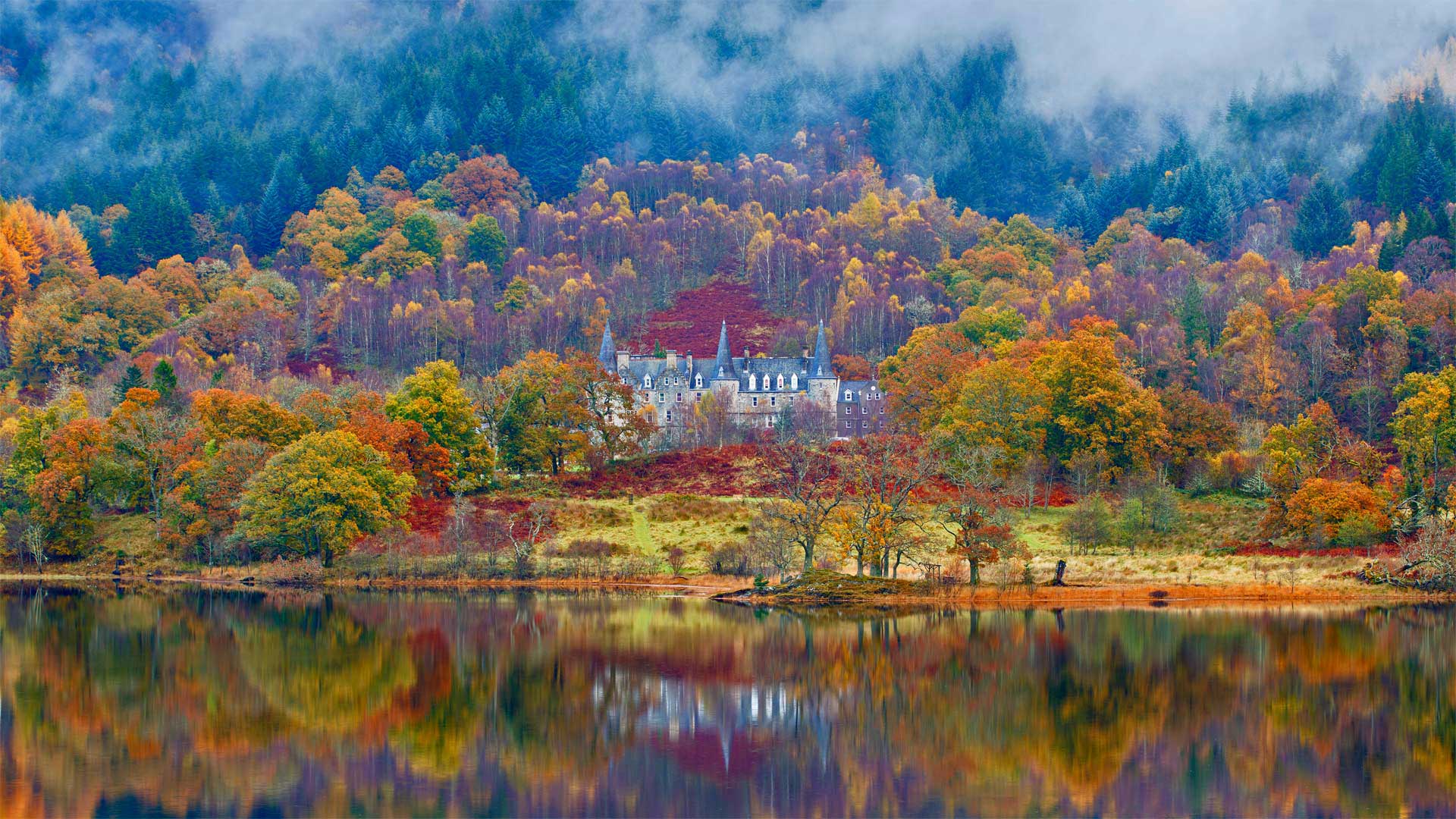
阿赫雷湖畔的泰莫特罗萨克斯城堡酒店,苏格兰 Tigh Mor Trossachs on Loch Achray, Scotland (© Fortunato Gatto/eStock Photo)
阿赫雷湖畔的泰莫特罗萨克斯城堡酒店,苏格兰 Tigh Mor Trossachs on Loch Achray, Scotland (© Fortunato Gatto/eStock Photo)
重温往日辉煌 Reflecting its stylish past today
苏格兰Achray湖上的Tigh Mor Trossachs
童话城堡?检查迷人的苏格兰背景?检查平静,宁静的湖水?检查如果Tigh Mor在你看来像田园诗一样,你并不孤单。维多利亚女王在这里度过了全盛时期,尽管这座建于1849年的老酒店多年来衰落了,但耗资数百万美元的修复让它重新回到了昔日的辉煌。
Tigh Mor坐落在苏格兰特罗萨赫的Achray湖上方,这一地区的景色令人惊叹,让艺术家和画家如飞蛾扑火。作家们也受到了它的美丽的启发:早在19世纪初,沃尔特·斯科特爵士的诗歌《湖中的女士》和小说《罗布·罗伊》就激起了人们对游览这片被称为“特罗萨克斯”的森林峡谷、布雷斯和水道的兴趣
今天,许多游客徒步旅行或骑自行车游览特罗萨克斯小径,这是一条美丽的40英里长的路线,从洛蒙湖开始,蜿蜒在河流和树林中,为家庭友好的探险以及山地自行车和攀岩者带来挑战。更像一个水的人?特罗萨克人还擅长独木舟、皮划艇、桨板、帆船、游泳以及在河流和湖泊上钓鱼。
Tigh Mor Trossachs on Loch Achray, Scotland
Fairy-tale castle? Check. Stunning Scottish backdrop? Check. Calm, tranquil loch? Check. If Tigh Mor looks idyllic to you, you're not alone. Queen Victoria spent time here in its heyday, and though the old hotel (it was built in 1849) declined over the years, a multimillion-dollar restoration has brought it right back to its former glory.
Tigh Mor sits above Loch Achray in Scotland's Trossachs, a region with scenery so stunning it draws artists and painters like moths to a flame. Writers are also inspired by its beauty: Way back in the early 1800s Sir Walter Scott's poem 'The Lady of the Lake' and novel 'Rob Roy' stirred interest in visiting this area of wooded glens, braes, and waterways called 'Trossachs.'
Today many visitors hike or bike the Trossachs Trail, a beautiful 40-mile route that starts at Loch Lomond and winds along rivers and through woods, offering family-friendly adventures as well as challenges for mountain bikers and rock-climbers. More of a water person? The Trossachs are also great for canoeing, kayaking, paddle boarding, sailing, swimming, and fishing on rivers and lochs aplenty.
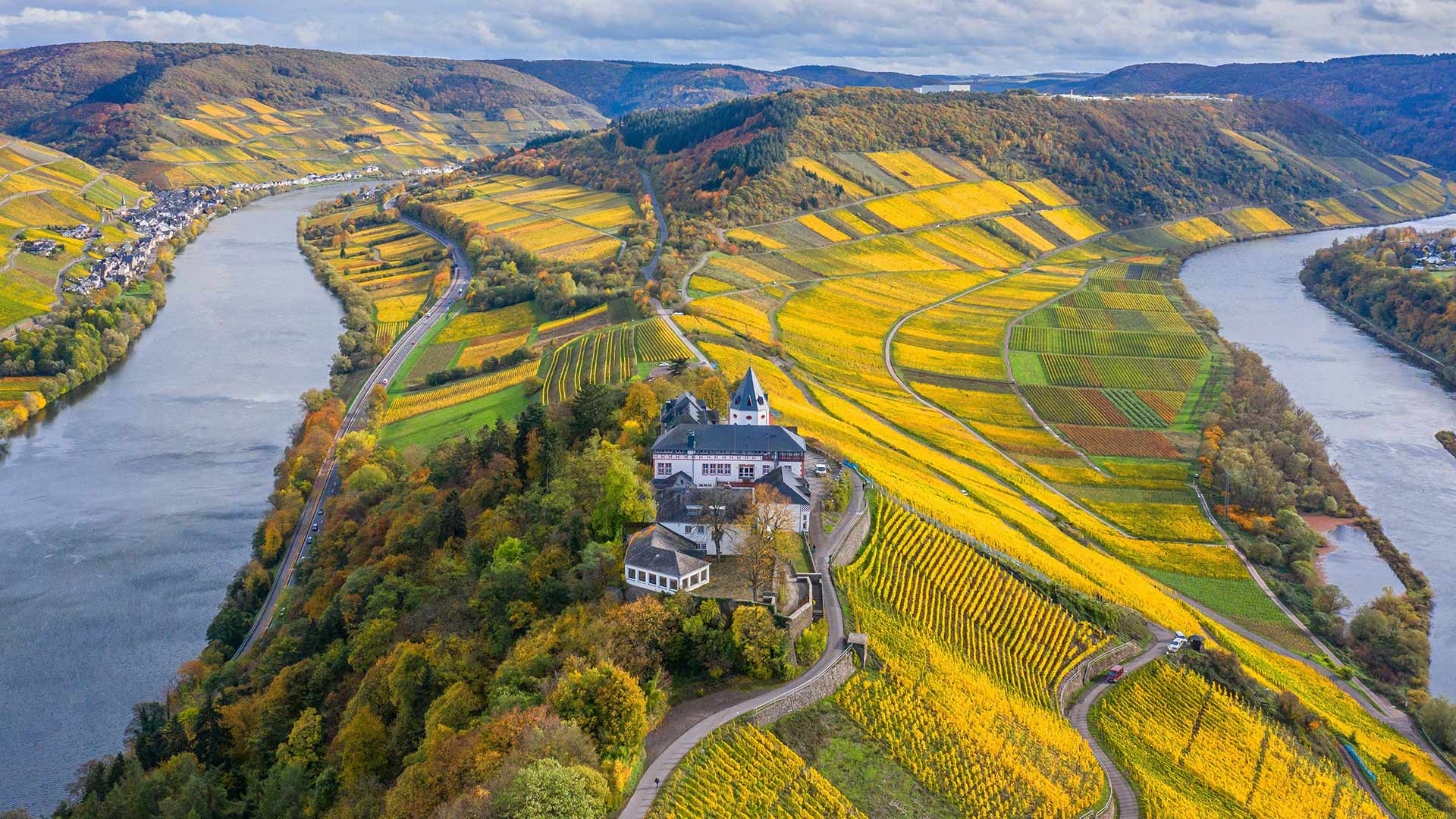
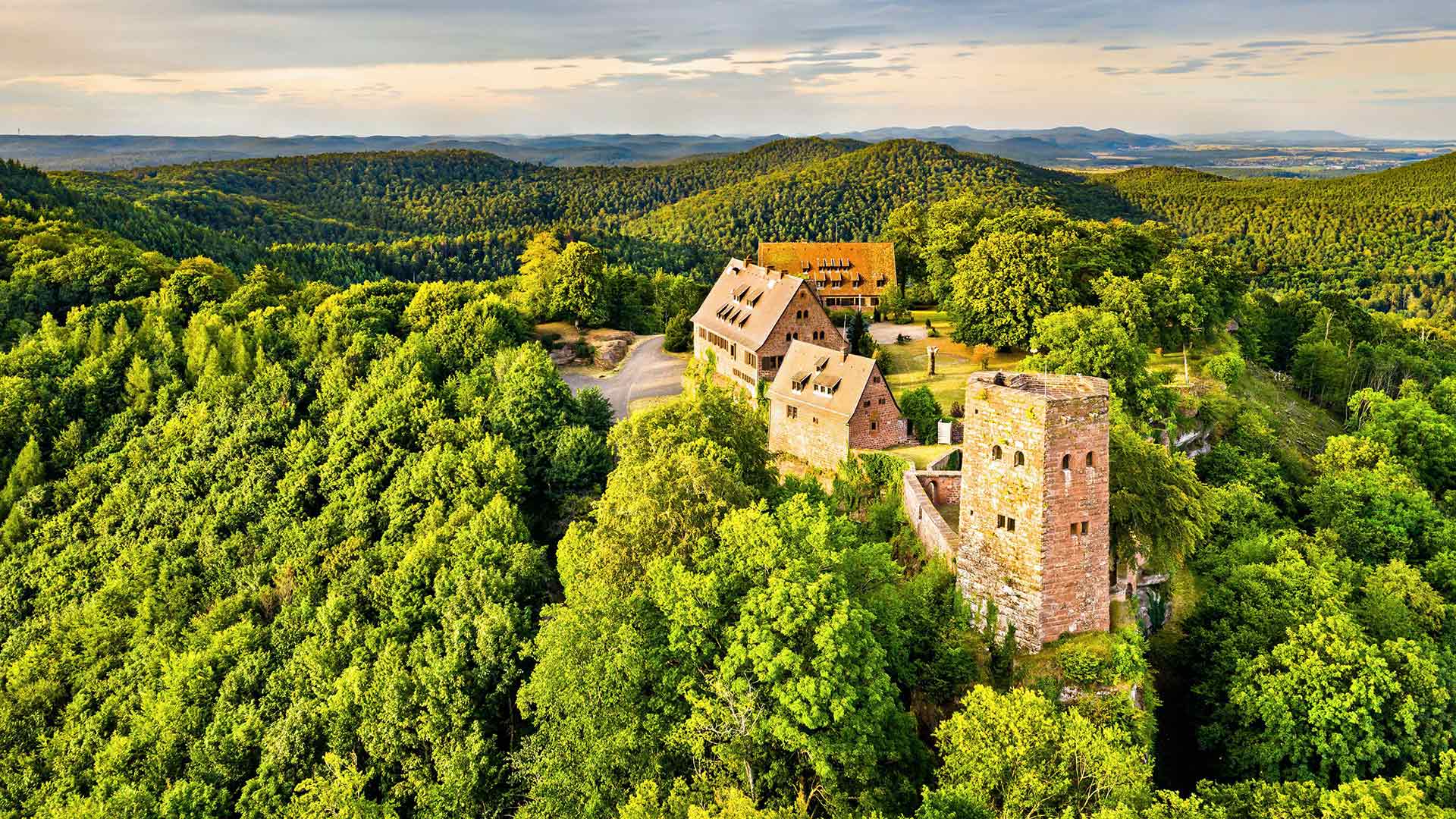
玛利恩堡,德国莱茵兰-普法尔茨州采尔县附近 Marienburg near Zell, Rhineland-Palatinate, Germany (© Eiben, Hans Georg/Alamy)
玛利恩堡,德国莱茵兰-普法尔茨州采尔县附近 Marienburg near Zell, Rhineland-Palatinate, Germany (© Eiben, Hans Georg/Alamy)
维尔茨堡美因河畔的一座城堡 Riverside castle
莱茵兰-帕拉蒂纳州马里恩堡
马里恩堡是德国维尔茨堡市美因河畔的一座城堡。它是维尔茨堡的象征,近5个世纪以来一直是王子和主教的故乡。它自古以来就是一座要塞。1631年,瑞典古斯塔夫二世阿道夫(Gustav II Adolf)征服该地区后,城堡被重建为巴洛克式要塞。今天,它是一个公园和博物馆。
Marienburg, Rhineland-Palatinate
Marienburg is a castle on the River Main in Wurzburg, Germany. It is the symbol of Wurzburg and has been the home of princes and bishops for nearly 5 centuries. It has been a fortress since ancient times. After Gustav II Adolf of Sweden conquered the area in 1631, the castle was rebuilt as a Baroque fortress. Today, it is a park and museum.
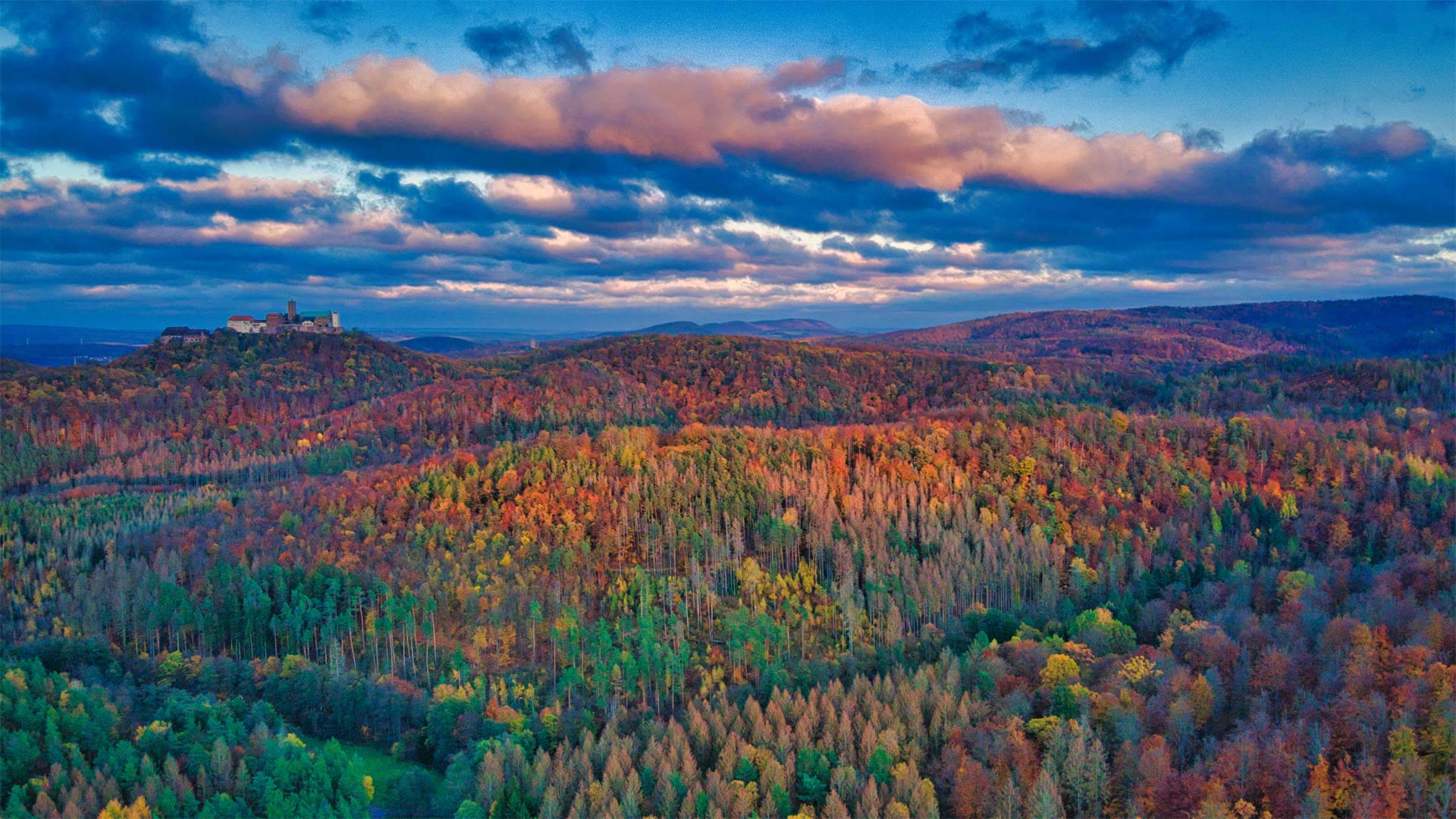
秋天的图林根森林与瓦特堡城堡,德国 Thuringian Forest in autumn with Wartburg Castle, Germany (© ezypix/Getty Images)
秋天的图林根森林与瓦特堡城堡,德国 Thuringian Forest in autumn with Wartburg Castle, Germany (© ezypix/Getty Images)
等等,这山上得有座城堡! 'Wait, mountain—you shall bear my castle!'
俯瞰德国图林根森林的沃特堡城堡
当你浏览今天德国图林根森林树木变色的照片时,请注意远处的城堡。这就是瓦茨堡,一座建于中世纪的城堡,对有信仰的人来说意义重大。它是图林根天主教圣伊丽莎白的故乡,也是马丁·路德流亡期间将新约翻译成德语的地方。它是该地区最受欢迎的旅游景点,以其典型的中世纪建筑而闻名。
关于沃特堡的命名,有一些巧妙的文字游戏正在进行。”“Warte”是德语中“watchtower”和“wait”的意思传统认为,城堡的创建者惊呼“Warte,Berg du sollst mir eine Burg tragen!”或者“等等,大山,你将承受我的城堡!”看到位置后。注意那句引语中的“berg”和“burg”,它们分别翻译为山和堡垒。因此,在德国将单词拼凑在一起的伟大传统中,沃特堡这个名字应运而生。
如果你对这座城堡不感兴趣,那么素有“德国绿心”之称的图林根森林对游客来说也有其独特的魅力。德国最古老、最受欢迎的长途徒步旅行步道伦斯泰格(Rennsteig)在森林中绵延约110英里。如果你外出徒步旅行,你会注意到该地区总体上很安静,空气清新、无污染。你甚至可能会遇到一些小村庄,这些村庄遍布该地区,以欢迎外来者而闻名。
Wartburg Castle overlooking Thuringian Forest in Germany
As you glance over today's photo of the trees changing color in Thuringian Forest in Germany, make note of the castle in the distance. That's Wartburg, a castle built in the Middle Ages that holds significance to people of faith. It was the home of the Catholic Saint Elizabeth of Thuringia, and also where Martin Luther translated the New Testament into German while in exile. It's the area's most popular tourist attraction and has been recognized for its quintessential medieval architecture.
There's some clever wordplay going on regarding how Wartburg was named. 'Warte' is German for both 'watchtower' and 'wait.' Tradition suggests the castle's founder exclaimed 'Warte, Berg—du sollst mir eine Burg tragen!' or 'Wait, mountain—you shall bear my castle!' upon seeing the location. Note the 'berg' and 'burg' in that quote, which translate to mountain and fortress, respectively. And so in the grand German tradition of mashing words together, the name Wartburg came to be.
If the castle isn't of interest to you, Thuringian Forest, known as the Green Heart of Germany, has plenty of its own charm for tourists. The oldest and most popular long-distance hiking trail in Germany, the Rennsteig, runs for about 110 miles within the forest. If you're out for a hike you'll notice the general quietness of the area and fresh, unpolluted air. You may even happen upon the tiny villages that pepper the area and have a reputation for welcoming outsiders.
奇陶尔加尔堡,印度 Chittorgarh Fort, India (© Anand Purohit/Getty Images)
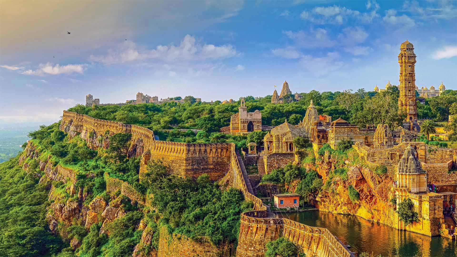
奇陶尔加尔堡,印度 Chittorgarh Fort, India (© Anand Purohit/Getty Images)
Chittorgarh Fort Rajasthan India
At 8 miles in circumference, the Chittorgarh Fort is one of the largest forts in India, a nation with scores of ancient and medieval fortresses. For starters there are seven massive gates from which to enter. Inside you'll find four palaces and 19 temples. At one time there were almost 100 bodies of water, most of them ponds fed by natural catchment and rainfall, although now there are only 20. Chittorgarh ('garh' means 'fort,' so it's also known as Chittor Fort) is so old, no one is sure exactly when it was built, although reports of its earliest capture go back to the 8th century. It is one of a cluster of six large forts in the northwestern state of Rajasthan referred to as the Hill Forts of Rajasthan, all of them collectively designated a UNESCO World Heritage Site. We're featuring this important and ancient complex on India's 75th Independence Day, one of India's three national holidays.
On August 15, 1947, India officially broke free of Great Britain and became a sovereign and democratic nation with the speedy passage of the Indian Independence Act. The paperwork might have been fast, but the struggle for independence from British rule lasted 90 years and cost many Indian lives. The British controlled the Indian subcontinent for nearly 200 years, after winning the decisive Battle of Plassey in 1757. The victory allowed the English East India Company to eventually exercise control over most of the rest of the Indian subcontinent, Burma, and Afghanistan. East India remained the supreme authority in India for a century until 1857 when a massive rebellion by civilians and Indian soldiers against the company was suppressed, resulting in direct British rule, referred to as the British raj.
The ensuing decades saw the formation of the Indian National Congress, the rise of Indian nationalism, various armed rebellions, and many acts of civil disobedience led by Mahatma Gandhi and others, before independence was finally achieved. While India as we know it is still a very young nation, the Chittor Fort reminds us the land and people that created modern India have endured and thrived for millennia.
印度拉贾斯坦邦的奇托加尔堡
奇托加尔要塞周长8英里,是印度最大的要塞之一,该国拥有数十座古代和中世纪要塞。首先,有七扇巨大的大门可以进入。里面有四座宫殿和19座寺庙。曾经有近100个水体,其中大部分是由自然集水和降雨形成的池塘,尽管现在只有20个。奇托加尔(Chittorgar,意为“堡垒”,所以也被称为奇托堡)非常古老,没有人确切知道它是何时建成的,尽管关于最早捕获的报道可以追溯到8世纪。它是西北部拉贾斯坦邦的六座大型堡垒群之一,被称为拉贾斯坦山的希尔堡垒,所有这些堡垒都被联合国教科文组织列为世界遗产。在印度的第75个独立日,印度的三个法定假日之一,我们将展示这座重要而古老的建筑群。
1947年8月15日,随着《印度独立法》的迅速通过,印度正式脱离英国,成为一个主权民主国家。文书工作可能很快,但脱离英国统治的独立斗争持续了90年,夺走了许多印度人的生命。1757年,英国人在普拉西决定性战役中获胜后,控制了印度次大陆近200年。这场胜利使英国东印度公司最终控制了印度次大陆的大部分其他地区,缅甸和阿富汗。一个世纪以来,东印度一直是印度的最高权力机构,直到1857年,平民和印度士兵对该公司的大规模叛乱被镇压,导致英国直接统治,称为英国统治。
随后的几十年见证了印度国民大会的成立、印度民族主义的兴起、各种武装叛乱以及圣雄甘地等人领导的许多公民不服从行为,最终实现了独立。虽然我们所知的印度仍然是一个非常年轻的国家,但奇托堡提醒我们,创造现代印度的土地和人民已经忍受并繁荣了数千年。
兰贝里斯山口脚下的多尔巴达恩城堡,威尔士 (© Viktoria Rodriguez/Getty Images)
塔菲拉勒地区的一座古老古堡, 摩洛哥 An old kasbah in the Tafilalet region, Morocco (© José Antonio Moreno/agefotostock)
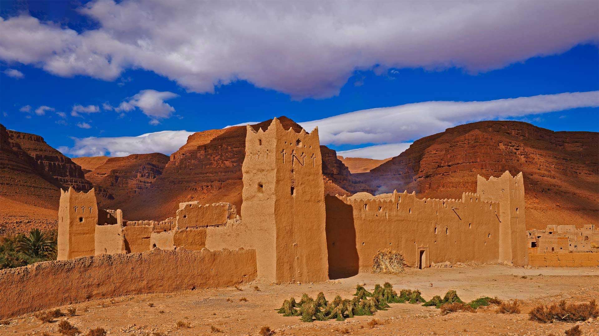
塔菲拉勒地区的一座古老古堡, 摩洛哥 An old kasbah in the Tafilalet region, Morocco (© José Antonio Moreno/agefotostock)
沙海中的绿洲 An oasis in a sea of sand
Tafilalet oasis in Morocco
Tafilalet means 'jug' in the language of the ancient Amazigh people (aka Berbers), and that's surely an appropriate moniker for the largest oasis in Morocco. After the first permanent settlement of the region, Sijilmassa, was founded in 757 CE, Tafilalet became a stopping point for caravans traveling from the Niger River to Tangier on the northern tip of Morocco and the gateway to Europe.
The oasis here at Tafilalet thrives thanks to underground springs and wells, which are supplied by sandstone aquifers that can be hundreds of miles away. Surrounded by the dry sands of the Sahara, the lifegiving waters here at Tafilalet support miles of date palm groves, a major industry in North Africa. Over the centuries, several villages have sprung up in this oasis, some of them with fortified kasbahs like this one, to withstand attacks from invaders.
摩洛哥塔菲拉莱绿洲
Tafilalet在古代亚马齐格人(又名柏柏柏尔人)的语言中是“jug”的意思,这无疑是摩洛哥最大绿洲的恰当称呼。公元757年,该地区建立了第一个永久定居点Sijilmassa,塔菲拉莱成为商队从尼日尔河前往摩洛哥北端丹吉尔的停靠点,也是通往欧洲的门户。
塔菲拉勒的绿洲因地下泉水和水井而繁荣,这些泉水和水井由数百英里以外的砂岩含水层提供。塔菲拉莱的生命之水被撒哈拉沙漠的干沙所包围,支撑着数英里的椰枣林,这是北非的一个主要产业。几个世纪以来,这片绿洲中涌现出了几个村庄,其中一些村庄有像这样的设防卡斯巴,以抵御入侵者的袭击。
护城河边的格吕克斯堡城堡,德国 (© Christian Back/eStock Photo)
下莱茵省的胡内城堡,法国阿尔萨斯大区 Château de Hunebourg, Bas-Rhin, Alsace, France (© Leonid Andronov/Alamy)
下莱茵省的胡内城堡,法国阿尔萨斯大区 Château de Hunebourg, Bas-Rhin, Alsace, France (© Leonid Andronov/Alamy)
12世纪的历史遗迹 The castle of a thousand and one lives
Château de Hunebourg
Today, we take a breath of fresh air, nature and history with this view of the Alsatian castle of Hunenbourg, located west of Neuwiller-lès-Saverne, in the Bas-Rhin, in Alsace. The castle of Hunebourg, listed as a Historic Monument since June 2007, is installed on a sandstone rock 425 meters above sea level and accessible by the Zinsel valley.
Formerly owned by the Counts of Hunebourg, the castle was built in the 12th century. Years after years, it passed from hand to hand. In the second half of the 20th century, the castle became what it still is today, a hotel.
The site welcomes its visitors in an exceptional natural setting where you can still admire the remains of the original building such as the floors and furniture, the cave of Love, which was used as a place for romantic dates, reconstructed by Spieser, or the markers of divided areas.
胡内堡城堡酒店
今天,我们在阿尔萨斯下莱茵河畔的纽威勒-莱斯-萨维恩以西的胡嫩堡阿尔萨斯城堡中呼吸新鲜空气、自然和历史。Huneburg城堡自2007年6月起被列为历史遗迹,它坐落在海拔425米的砂岩上,可通过Zinsel山谷进入。
这座城堡曾为胡内堡伯爵所有,建于12世纪。年复一年,它从一个手传到另一个手。在20世纪下半叶,城堡变成了今天的酒店。
该景点以独特的自然环境欢迎游客,在这里,你仍然可以欣赏原始建筑的遗迹,如地板和家具、被斯皮泽重建的爱情洞穴,或分割区域的标记。
梅萨维德国家公园的方形塔楼,美国科罗拉多州 Square Tower House in Mesa Verde National Park, Colorado (© lightphoto/Getty Images)
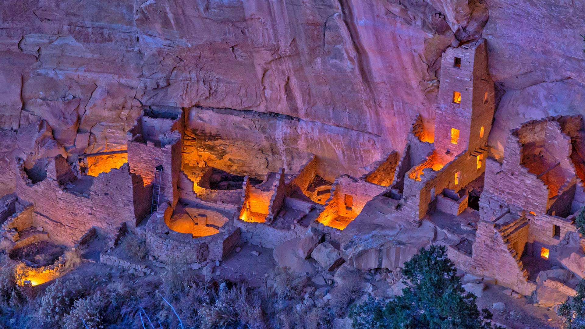
梅萨维德国家公园的方形塔楼,美国科罗拉多州 Square Tower House in Mesa Verde National Park, Colorado (© lightphoto/Getty Images)
普韦布洛城堡 Castle of the Ancestral Puebloans
Square Tower House in Mesa Verde National Park
We continue our celebration of National Park Week (through April 24)–and the UNESCO International Day for Monuments and Sites–with a visit to the impressive Square Tower House in Mesa Verde National Park. Square Tower House is one of many cliff dwellings constructed by the Ancestral Puebloans in what is now the American Southwest. At 27 feet, it's the tallest structure in the park. Square Tower House is also notable for its kiva, a round, sunken room used for ceremonies. Unlike most of the ancient kivas found in the region, the kiva at Square Tower House has an intact original clay roof supported by wooden beams.
Ancestral Puebloans lived in today's Four Corners region, where the borders of Colorado, Utah, Arizona, and New Mexico meet at a single point. It's unclear when exactly this culture emerged, but the current consensus is that the Ancestral Puebloans appeared in this area a little more than 3,000 years ago. They're believed to have built the series of cliff dwellings for defensive reasons as various factions competed for scarce resources when the region suffered from a prolonged drought. It's thought that the changing climate eventually became so severe that it likely drove them from the cliff dwellings sometime around 1300 CE, just a century or so after construction began. Today, many of the cliff dwellings have been restored and visitors can view the homes and kivas of the builders.
梅萨维德国家公园的方形塔楼
我们继续庆祝国家公园周(至4月24日)——以及联合国教科文组织纪念物和遗址国际日——参观梅萨维德国家公园令人印象深刻的方形塔楼。方塔住宅是普埃布劳恩斯家族在现在的美国西南部建造的众多悬崖住宅之一。它高27英尺,是公园里最高的建筑。方形塔楼房屋也因其kiva而著名,kiva是一个圆形的下沉式房间,用于举行仪式。与该地区发现的大多数古代基瓦不同,广场塔楼的基瓦房屋有一个完整的原始粘土屋顶,由木梁支撑。
普韦布劳恩斯的祖先生活在今天的四角地区,科罗拉多州、犹他州、亚利桑那州和新墨西哥州的边界在这里交汇。目前尚不清楚这种文化是什么时候出现的,但目前的共识是,祖先普韦布洛人在3000多年前就出现在这个地区。据信,当该地区遭受长期干旱时,各派系为了争夺稀缺资源,出于防御原因,他们修建了一系列悬崖住宅。据认为,气候变化最终变得如此严重,可能在公元1300年左右的某个时候,也就是建筑开始后的一个世纪左右,将他们赶出悬崖住宅。如今,许多悬崖上的住宅已经修复,游客可以看到建筑商的房屋和地窖。