哥本哈根市政厅广场Richshuset大楼顶部的“Vejrpigerne”(“天气女孩”)雕塑, 丹麦 'Vejrpigerne' ('The Weather Girls') sculpture on top of the Richshuset building in City Hall Square in Copenhagen, Denmark (© Stig Alenas/Shuttersto
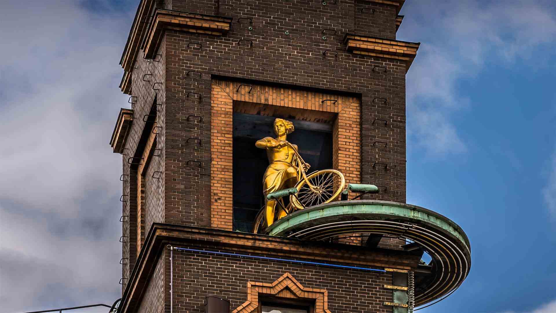
哥本哈根市政厅广场Richshuset大楼顶部的“Vejrpigerne”(“天气女孩”)雕塑, 丹麦 'Vejrpigerne' ('The Weather Girls') sculpture on top of the Richshuset building in City Hall Square in Copenhagen, Denmark (© Stig Alenas/Shutterstock)
Perfect day for a ride 完美的骑行日
The Weather Girls
Presiding over City Hall Square on the Richshuset building in Copenhagen, 'The Weather Girls' sculpture will help launch this year's Tour de France, which will see riders in Stage 1 today cycling past iconic landmarks of the Danish capital like Tivoli Gardens and the Little Mermaid statue. From here, the racers will ride through other parts of Denmark, Belgium, Switzerland, and of course France before ending with the final stage on the Champs-Élysées in Paris on July 24.
Copenhagen seems a fitting starting point for the world's most famous bike race, since it's so well known for being heavily invested in cycling for transportation, healthy living, and a commitment to green energy. That love affair with bikes is reflected in the cyclist figure of today's homepage image. Created by painter-turned-sculptor Einar Utzon-Franck in 1936, 'The Weather Girls' used to provide a quick forecast for folks on the square. Situated atop a rotating disc, the girl on the bike that we see here would spin out if fair weather was in the forecast. But if rain was expected, she would emerge with an umbrella.
The sculpture is no longer functional as a barometer, but the cycling figure mirrors the Danes in general—always out biking, rain or shine. The country makes cycling as convenient and enjoyable as possible, with separate traffic lights, dedicated bike lanes, cyclist-friendly traffic laws, and thousands of miles of segregated bike paths. Even the world-class competitors in the Tour de France would appreciate that.
天气女孩
“天气女孩”雕塑位于哥本哈根Richshuset大楼的市政厅广场,将有助于启动今年的环法自行车赛。今天,第一阶段的骑手将骑自行车经过丹麦首都的标志性地标,如蒂沃利花园和小美人鱼雕像。从这里开始,参赛者将穿越丹麦、比利时、瑞士,当然还有法国的其他地区,然后于7月24日在巴黎的香榭丽舍(Champs-Éysées)进行最后阶段的比赛。
哥本哈根似乎是世界上最著名的自行车比赛的合适起点,因为它以在自行车交通、健康生活和绿色能源方面的大量投资而闻名。这种对自行车的热爱反映在今天的主页图片中的骑自行车者形象中。《天气女孩》由画家兼雕塑家埃纳·乌特松·弗兰克于1936年创作,曾为广场上的人们提供快速预报。如果天气预报说天气晴朗的话,我们在这里看到的骑自行车的女孩会在旋转的圆盘上旋转。但如果预计会下雨,她就会带着雨伞出现。
雕塑不再具有晴雨表的功能,但骑自行车的人像反映了丹麦人无论晴雨总是外出骑自行车。该国通过独立的红绿灯、专用自行车道、对骑自行车者友好的交通法规以及数千英里的独立自行车道,使自行车尽可能方便和愉快。即使环法自行车赛的世界级选手也会对此表示感谢。
阿圭罗村庄, 韦斯卡, 西班牙 (© Francesco Carovillano/eStock)
阿克拉曼火山口, 澳大利亚 The Acraman crater, Australia (© USGS/NASA Landsat data/Orbital Horizon/Gallo Images/Getty images)
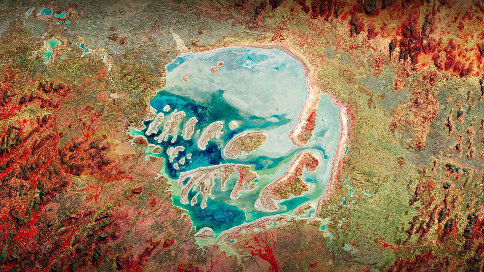
阿克拉曼火山口, 澳大利亚 The Acraman crater, Australia (© USGS/NASA Landsat data/Orbital Horizon/Gallo Images/Getty images)
Will we be ready for the 'big one'? 我们准备好迎接“大挑战”了吗?
Asteroid Day
Today is Asteroid Day, and it's a reminder that as our planet follows its path around the sun, it encounters a lot of stuff. Science tells us that, every day, Earth's atmosphere is hit with roughly 100 tons of dust and particles the size of a grain of sand. And every year, at least 30 small meteors make it through, only to burn up before touching the ground. NASA says it's pretty much guaranteed that at least one of them will be about the size of a car. As time progresses, the likelihood increases that even larger celestial rocks will hit the ground and cause significant damage.
Across the globe, there are plenty of reminders of this in the form of craters, like the one in today's photo. The Acraman crater is a point of impact in South Australia. It's believed to have been created about 590 million years ago when hit by an asteroid with a diameter that could have been as large as 56 miles across. For comparison, the asteroid thought to have killed the dinosaurs 66 million years ago was 6.2 miles across. NASA says that an asteroid the size of a football field would cause significant damage. One that could really threaten civilization hits every few million years. Hopefully, with Asteroid Day being observed across 78 countries since its inception in 2015, we'll be prepared when the 'big one' shows up.
小行星日
今天是小行星日,它提醒我们,当我们的行星沿着它围绕太阳的轨道运行时,它会遇到很多东西。科学告诉我们,每天,地球大气层都会受到大约100吨沙粒大小的灰尘和颗粒的撞击。每年,至少有30颗小流星穿过,但在到达地面之前就被烧毁了。美国宇航局表示,几乎可以保证其中至少有一辆车的大小。随着时间的推移,更大的天体岩石撞击地面并造成重大损害的可能性增加。
在全球范围内,有很多火山口的形式提醒着我们这一点,就像今天照片中的一样。阿克拉曼火山口是南澳大利亚的一个撞击点。据信,它是在大约5.9亿年前被一颗直径可达56英里的小行星撞击时形成的。相比之下,被认为在6600万年前杀死恐龙的小行星直径为6.2英里。美国宇航局表示,足球场大小的小行星将造成重大破坏。每几百万年就会有一次真正威胁文明的袭击。有希望的是,自2015年小行星日成立以来,全球78个国家都在纪念小行星日,我们将在“大一号”出现时做好准备。
基伯龙半岛上的海滩,法国布列塔尼地区 (© hardyun/Adobe)
攀牙湾安达曼海的红树林,泰国 Mangrove forest in Phang Nga Bay, Andaman Sea, Thailand (© Ratnakorn Piyasirisorost/Getty Images)
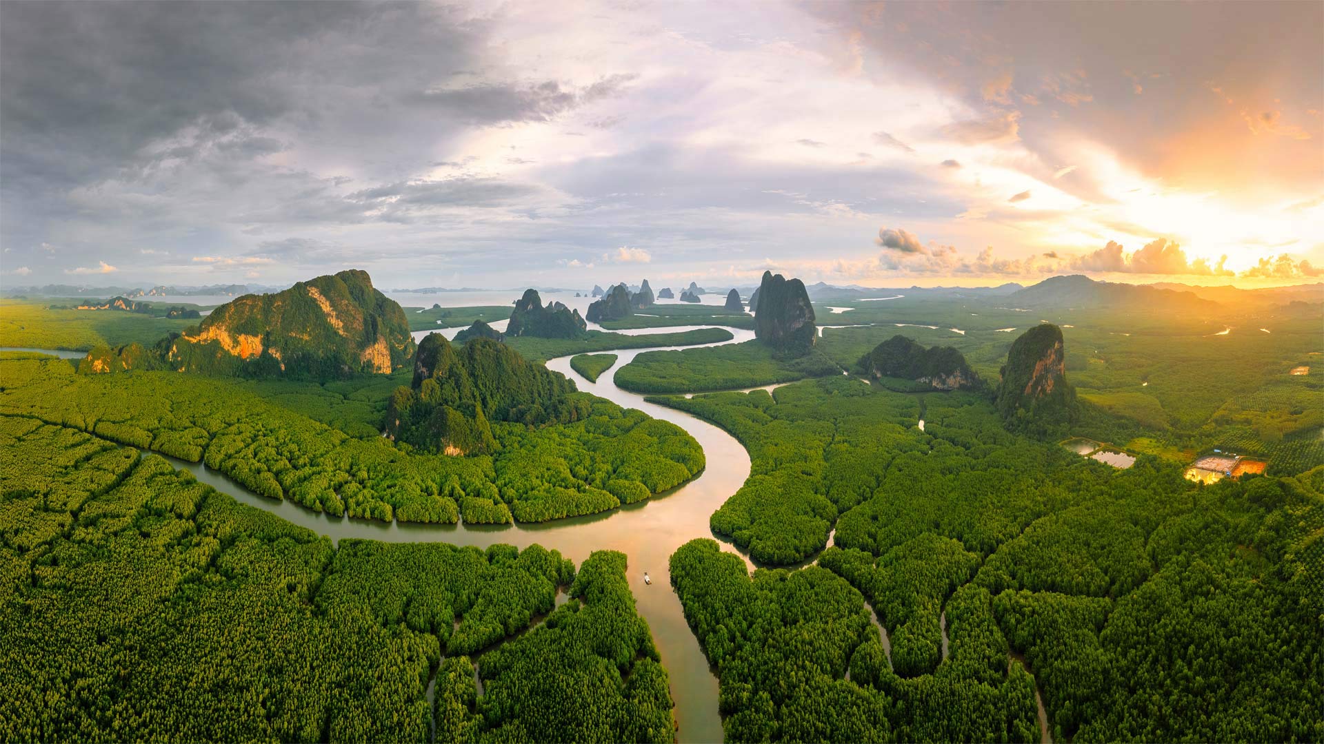
攀牙湾安达曼海的红树林,泰国 Mangrove forest in Phang Nga Bay, Andaman Sea, Thailand (© Ratnakorn Piyasirisorost/Getty Images)
在热带,陆地与海洋热情相拥 In the tropics, land greets sea warmly
International Day of the Tropics
Only in the tropics do forests grow in salt water. Take this forest of mangrove trees in Phang Nga Bay in southern Thailand, one of the largest and best preserved mangrove forests in the country. Adapted to thrive in coastal marshes and swamps, mangroves can filter saltwater and withstand strong coastal storms. Virtually all mangrove forests and all species of mangrove grow only in the tropical regions of the world. They are protectors of the coastlines, acting as a buffer against storms and floods.
Today and on every June 29, we join the United Nations in marking the International Day of the Tropics, a moment to focus on the unique beauty of this region of the world and the challenges it faces. The tropics are roughly defined as the area above and below the equator between the Tropic of Cancer and the Tropic of Capricorn. By 2050, the UN estimates the tropics will be home to most of the humans on Earth, and two-thirds of the world's children. It is also the poorest part of our world and the most vulnerable to global warming.
Phang Nga Bay on the Andaman Sea is one of the most treasured and visited sites in Thailand. The south-facing bay is about 150 square miles in size, and contains numerous limestone islets, tower karsts, cliffs, caves, and lagoons. At its mouth is the tourist mecca of Phuket island. Much of the bay is protected as the Ao Phang Nga National Park, created in 1981 by royal decree. The most famous landmark in the park is probably Ko Tapu, a tall cylindrical rock that is narrower at its base than at its top. It was featured in the 1974 James Bond movie 'The Man with the Golden Gun,' and has since been dubbed 'James Bond Island.' The real star of Phang Nga, however, is the mangrove. Resilient, wondrous, and beautiful, mangroves are an apt metaphor for the tropics they inhabit.
国际热带日
只有在热带地区,森林才能在盐水中生长。以泰国南部攀牙湾的红树林为例,攀牙湾是泰国最大、保存最完好的红树林之一。红树林适应于在沿海沼泽和沼泽中生长,可以过滤海水,抵御强烈的沿海风暴。几乎所有红树林和所有红树林物种都只生长在世界热带地区。它们是海岸线的保护者,起着抵御风暴和洪水的缓冲作用。
今天和每年6月29日,我们与联合国一道纪念国际热带日,这是一个关注世界这一地区独特美景及其面临挑战的时刻。热带大致定义为北回归线和北回归线之间赤道上下的区域。联合国估计,到2050年,热带地区将成为地球上大多数人类和世界三分之二儿童的家园。它也是世界上最贫穷的地区,也是最容易受到全球变暖影响的地区。
安达曼海上的攀牙湾是泰国最珍贵的景点之一。朝南的海湾面积约150平方英里,包含许多石灰岩小岛、塔式岩溶、悬崖、洞穴和泻湖。河口是普吉岛的旅游圣地。该湾的大部分地区被保护为1981年根据皇家法令创建的敖攀牙国家公园。公园中最著名的地标可能是Ko Tapu,这是一种高大的圆柱形岩石,底部比顶部窄。它曾出现在1974年詹姆斯·邦德的电影《金枪侠》中,后来被称为“詹姆斯·邦德岛”然而,攀牙岛真正的明星是红树林。红树林富有弹性、奇妙而美丽,是它们所居住热带的恰当隐喻
塔菲拉勒地区的一座古老古堡, 摩洛哥 An old kasbah in the Tafilalet region, Morocco (© José Antonio Moreno/agefotostock)
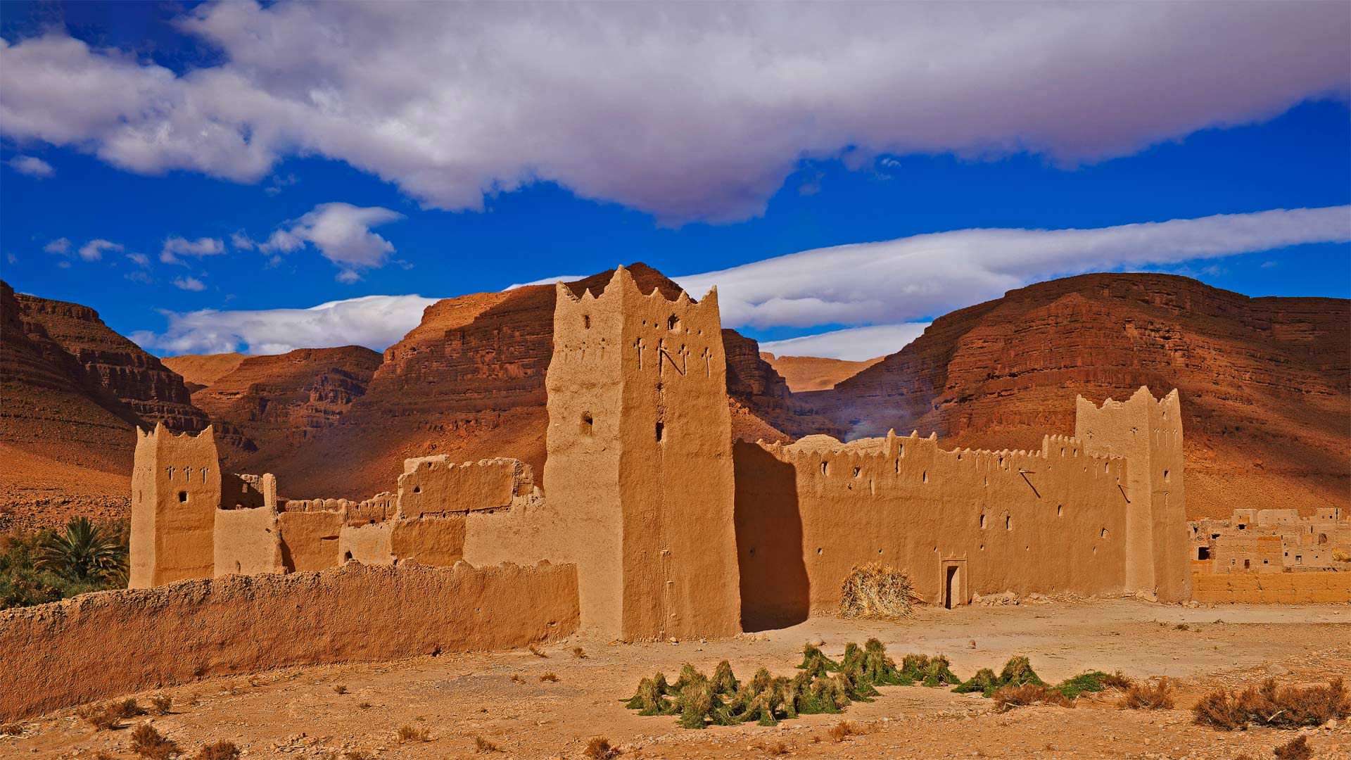
塔菲拉勒地区的一座古老古堡, 摩洛哥 An old kasbah in the Tafilalet region, Morocco (© José Antonio Moreno/agefotostock)
沙海中的绿洲 An oasis in a sea of sand
Tafilalet oasis in Morocco
Tafilalet means 'jug' in the language of the ancient Amazigh people (aka Berbers), and that's surely an appropriate moniker for the largest oasis in Morocco. After the first permanent settlement of the region, Sijilmassa, was founded in 757 CE, Tafilalet became a stopping point for caravans traveling from the Niger River to Tangier on the northern tip of Morocco and the gateway to Europe.
The oasis here at Tafilalet thrives thanks to underground springs and wells, which are supplied by sandstone aquifers that can be hundreds of miles away. Surrounded by the dry sands of the Sahara, the lifegiving waters here at Tafilalet support miles of date palm groves, a major industry in North Africa. Over the centuries, several villages have sprung up in this oasis, some of them with fortified kasbahs like this one, to withstand attacks from invaders.
摩洛哥塔菲拉莱绿洲
Tafilalet在古代亚马齐格人(又名柏柏柏尔人)的语言中是“jug”的意思,这无疑是摩洛哥最大绿洲的恰当称呼。公元757年,该地区建立了第一个永久定居点Sijilmassa,塔菲拉莱成为商队从尼日尔河前往摩洛哥北端丹吉尔的停靠点,也是通往欧洲的门户。
塔菲拉勒的绿洲因地下泉水和水井而繁荣,这些泉水和水井由数百英里以外的砂岩含水层提供。塔菲拉莱的生命之水被撒哈拉沙漠的干沙所包围,支撑着数英里的椰枣林,这是北非的一个主要产业。几个世纪以来,这片绿洲中涌现出了几个村庄,其中一些村庄有像这样的设防卡斯巴,以抵御入侵者的袭击。
普罗旺斯瓦朗索勒高原上的薰衣草田,法国 Lavender fields on the Valensole Plateau in Provence, France (© Shutterstock)
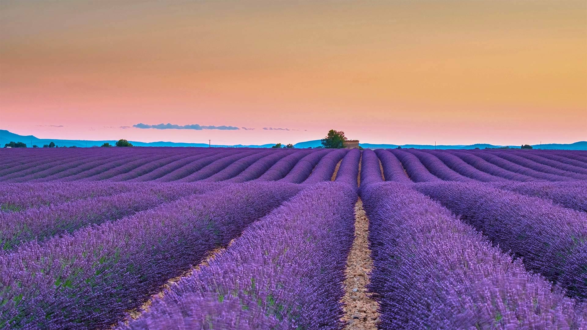
普罗旺斯瓦朗索勒高原上的薰衣草田,法国 Lavender fields on the Valensole Plateau in Provence, France (© Shutterstock)
一望无际的田野 Fragrant fields as far as the eye can see
Lavender fields on the Valensole Plateau in Provence, France
We're sorry. The scratch 'n' sniff option was not ready in time for this photo, so you'll have to imagine the intoxicating fragrance wafting over you…. Today we're in the lavender fields that carpet the Valensole Plateau in Provence, France. A rolling 300 square miles of flowers color the landscape as far as the eye can see. Vincent van Gogh spent time here, and featured lavender in some of his paintings. June is the start of the lavender season, and though it runs till August, peak viewing (and smelling) time varies a little with fluctuations in temperature and rainfall. There are lovely villages that you can meander while visiting the lavender fields, stopping for a pastry or crunchy-soft baguette at an outdoor cafe.
Hot, dry summers and plenty of sun help lavender thrive in the South of France and other countries that border the Mediterranean Sea. While we think the sight of lavender fields is relaxing in itself, the herb is always in demand for its essential oil, which lends a soothing scent to cosmetics, cleaning products, and even food. Some studies suggest that lavender can improve your sleep, reduce pain and inflammation, and improve anxiety and depression. The powerful plant was also used as an antiseptic in days gone by, as it has antimicrobial and antiviral properties.
法国普罗旺斯瓦伦索高原上的薰衣草田
我们很抱歉。抓挠和嗅嗅选项没有及时为这张照片做好准备,所以你必须想象那令人陶醉的香味飘荡在你身上…。今天,我们来到了覆盖法国普罗旺斯瓦伦索高原的薰衣草田。绵延300平方英里的花朵为眼前的风景增添了色彩。文森特·梵高在这里度过了一段时间,在他的一些画作中以薰衣草为特色。6月是薰衣草季节的开始,虽然一直持续到8月,但观赏(和闻)的高峰期会随着温度和降雨量的波动而略有变化。这里有一些可爱的村庄,你可以一边漫步,一边参观薰衣草田,一边在户外咖啡馆吃糕点或松脆柔软的法式面包。
炎热干燥的夏季和充足的阳光有助于薰衣草在法国南部和其他地中海沿岸国家茁壮成长。虽然我们认为看到薰衣草田本身就很轻松,但这种草本植物总是需要它的精油,它能给化妆品、清洁产品甚至食物带来舒缓的香味。一些研究表明,薰衣草可以改善睡眠,减轻疼痛和炎症,改善焦虑和抑郁。这种强大的植物在过去的几天里也被用作防腐剂,因为它具有抗菌和抗病毒的特性。
潜水员探索文图拉斯港附近的水下天然井,墨西哥 Scuba diver exploring the underwater cenotes near Puerto Aventuras, Mexico (© Extreme Photographer/Getty Images)
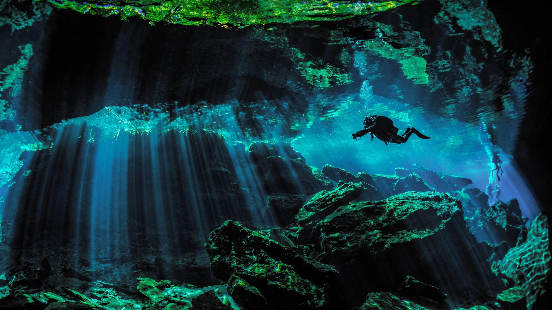
潜水员探索文图拉斯港附近的水下天然井,墨西哥 Scuba diver exploring the underwater cenotes near Puerto Aventuras, Mexico (© Extreme Photographer/Getty Images)
地面之下的水中世界 Underwater underground
Cenote near Puerto Aventuras, Mexico
Like a giant block of Swiss cheese, Mexico's Yucatan Peninsula is riddled with holes called cenotes. Cenotes form when subterranean limestone dissolves, allowing underground water to penetrate. The rock above may cave in, forming a pit and revealing the cool, often crystal-clear water, while other cenotes may remain hidden and unexplored. Cenotes vary in size from very small to several dozen yards across, and recent discoveries have shown that cenotes lead to a series of underground cave systems that can span several miles in length.
In a region with little rainfall and no rivers or streams, the Yucatan's 6,000 cenotes were vital to the many cities of the Mayan civilization that used them as a primary source of fresh water. While some of the peninsula's cenotes have a mix of salt water and fresh water, many of the holes have remarkably clean fresh water that has slowly filtered through rock. The diffuse light that reaches into the underground chambers creates a magical effect. It makes for fantastic swimming and diving opportunities. Many of the larger cenotes feature platforms and ropes to jump off, and they are often located near historically significant Mayan ruins.
墨西哥Aventuras港附近的Cenote
墨西哥的尤卡坦半岛就像一块巨大的瑞士奶酪,布满了被称为洞穴的洞。当地下石灰岩溶解时,会形成洞穴,使地下水渗入。上面的岩石可能会塌陷,形成一个坑,露出凉爽的,通常是水晶般清澈的水,而其他的洞穴可能仍然隐藏着,未经勘探。洞穴的大小从很小到几十码不等,最近的发现表明,洞穴形成了一系列地下洞穴系统,其长度可以跨越几英里。
在一个降雨量少、没有河流或溪流的地区,尤卡坦人的6000个纪念碑对玛雅文明的许多城市至关重要,玛雅文明将其作为淡水的主要来源。虽然半岛上的一些洞穴混合了咸水和淡水,但许多洞穴都有非常干净的淡水,这些淡水已经慢慢渗透到岩石中。进入地下室的漫射光创造了一种神奇的效果。它提供了绝佳的游泳和跳水机会。许多较大的纪念碑都有跳台和绳索,它们通常位于历史上重要的玛雅遗址附近。
莫斯塔尔古桥,波斯尼亚和黑塞哥维那 Stari Most in Mostar, Bosnia and Herzegovina (© Ayhan Altun/Getty Images)
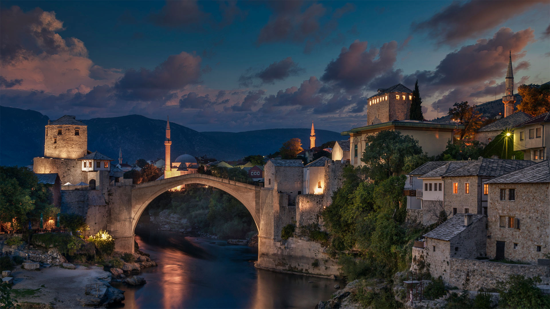
莫斯塔尔古桥,波斯尼亚和黑塞哥维那 Stari Most in Mostar, Bosnia and Herzegovina (© Ayhan Altun/Getty Images)
“古桥”的新生 The 'Old Bridge,' reborn
Stari Most in Mostar, Bosnia and Herzegovina
For 427 years the Mostar Bridge stood strong, despite the belief that its original mortar was composed of egg whites. Truth is, not much is known about the 16th-century construction of this bridge in what is now known as Bosnia and Herzegovina. All that remains in historical records are memories and legends and the name of the bridge's builder, Mimar Hayruddin. He was charged by Suleiman the Magnificent to build an unprecedentedly wide arch, and threatened with death if the structure failed. Hayruddin is said to have been so unsure of his creation that he had made funeral preparations before the scaffolding was removed. Luckily (and much to the builder's probable relief), the arch remained intact. Suspended nearly 80 feet above the Neretva River, the highest point of the bridge's arch rises an additional 39.5 feet. Upon its completion in 1566, it was the widest manmade arch ever built and was compared by one explorer to 'a rainbow arch soaring up to the skies.'
Also known as Stari Most, or 'Old Bridge,' it was finally brought down in November 1993 after being hit by a barrage of shells in a targeted attack during the Bosnian War. Considered a treasure of Bosnian Islamic architecture, its destruction by Croatian forces was condemned around the world. Scholars referred to the act as an attempt at 'killing memory.' Due to its importance in the Mostar region, plans to rebuild the bridge as accurately as possible began at the war's end. The reconstructed bridge was unveiled to the public in 2004. Used for normal daily activities, the bridge also has history as a popular spot for annual diving competitions.
波斯尼亚和黑塞哥维那莫斯塔尔的Stari Most
427年来,莫斯塔尔大桥一直屹立不倒,尽管人们相信它最初的砂浆是由蛋白组成的。事实是,关于16世纪在现在被称为波斯尼亚和黑塞哥维那的地方修建这座桥,人们所知不多。历史记录中只剩下记忆和传说,还有大桥建造者米马尔·海鲁丁的名字。宏伟的苏莱曼(Suleiman the Magnium)要求他建造一座空前宽阔的拱门,并威胁说,如果拱门倒塌,他将面临死亡。据说,海鲁丁对自己的创作非常不确定,以至于在拆除脚手架之前,他就已经为葬礼做了准备。幸运的是(建筑商可能松了一口气),拱门仍然完好无损。悬挂在内雷特瓦河上方近80英尺的地方,桥拱的最高点再高出39.5英尺。1566年建成后,这是有史以来建造的最宽的人造拱门,一位探险家将其比作“一座翱翔天空的彩虹拱门”
它也被称为“Stari Most”,或“Old Bridge”,1993年11月,在波斯尼亚战争期间,在一次有针对性的袭击中,它被一连串炮弹击中,最终被拆毁。被认为是波斯尼亚伊斯兰建筑的瑰宝,克罗地亚军队对其的破坏受到全世界的谴责。学者们把这一行为称为试图“扼杀记忆”由于该桥在莫斯塔尔地区的重要性,在战争结束时就开始了尽可能准确地重建该桥的计划。重建后的大桥于2004年向公众公布。该桥用于正常的日常活动,历史上也是年度跳水比赛的热门场地。
亚苏尼国家公园,厄瓜多尔 Yasuní National Park in Amazonian Ecuador (© Paul Bertner/Minden Pictures)

亚苏尼国家公园,厄瓜多尔 Yasuní National Park in Amazonian Ecuador (© Paul Bertner/Minden Pictures)
地球之肺 The lungs of Earth
World Rainforest Day
Perhaps no other place on Earth plays a more crucial role in sustaining life as we know it than the Amazon rainforest, the largest in the world. The Amazon spans nine countries in South America including Ecuador, where this pristine ecoregion is protected by the Yasuní National Park, shown here. Today is set aside as World Rainforest Day, to remember the vital role of this and other rainforests and to champion efforts to protect them. The world's rainforests are under threat like never before from deforestation driven by agriculture and cattle ranching. Some studies have indicated humans have degraded or destroyed more than half of the world's rainforests. Fewer trees mean warmer temperatures, which increases the risk of drought and wildfire and compounds the damage of deforestation.
The Amazon has been called the lungs of the planet because the estimated 390 billion trees here convert much of the oxygen humans and other animals need to survive. The Amazon also cools our planet by capturing and storing carbon. It is as much the planet's air conditioner as it is its lungs. For that reason, the health of rainforests is crucial to arresting climate change.
The other gift of rainforests, and of the Amazon in particular, is biodiversity. The number of species of plants, animals, and insects in the Amazon is not in the thousands, but in the millions. Scientists estimate half of the planet's biodiversity exists in the Amazon. In fact, many of our modern pharmaceuticals are derived from Amazon plants. That makes the Amazon not just the Earth's lungs and air conditioning, but also its medicine cabinet.
世界雨林日
也许地球上没有其他地方比世界上最大的亚马逊雨林在维持生命方面发挥着更重要的作用。亚马逊河横跨包括厄瓜多尔在内的南美洲九个国家,这里的亚苏尼国家公园保护着这个原始的生态区。今天被定为世界雨林日,以纪念这片和其他雨林的重要作用,并支持保护它们的努力。由于农业和畜牧业造成的森林砍伐,世界雨林受到前所未有的威胁。一些研究表明,人类已经退化或破坏了世界上一半以上的雨林。树木减少意味着气温升高,这增加了干旱和野火的风险,并加剧了毁林的破坏。
亚马逊河被称为地球的肺,因为这里估计有3900亿棵树转化了人类和其他动物生存所需的大部分氧气。亚马逊还通过捕获和储存碳来冷却我们的地球。它既是地球的空调,也是地球的肺。因此,雨林的健康对于遏制气候变化至关重要。
热带雨林,尤其是亚马逊的另一个礼物是生物多样性。亚马逊河流域的植物、动物和昆虫种类不是数千种,而是数百万种。科学家估计,地球上一半的生物多样性存在于亚马逊地区。事实上,我们的许多现代药物都来自亚马逊植物。这使得亚马逊不仅是地球的肺和空调,而且还是它的药柜。
