乌尤尼盐沼上的锥形盐堆,玻利维亚 Salt cones on the Salar de Uyuni, Bolivia (© John Shaw/Minden Pictures)
乌尤尼盐沼上的锥形盐堆,玻利维亚 Salt cones on the Salar de Uyuni, Bolivia (© John Shaw/Minden Pictures)
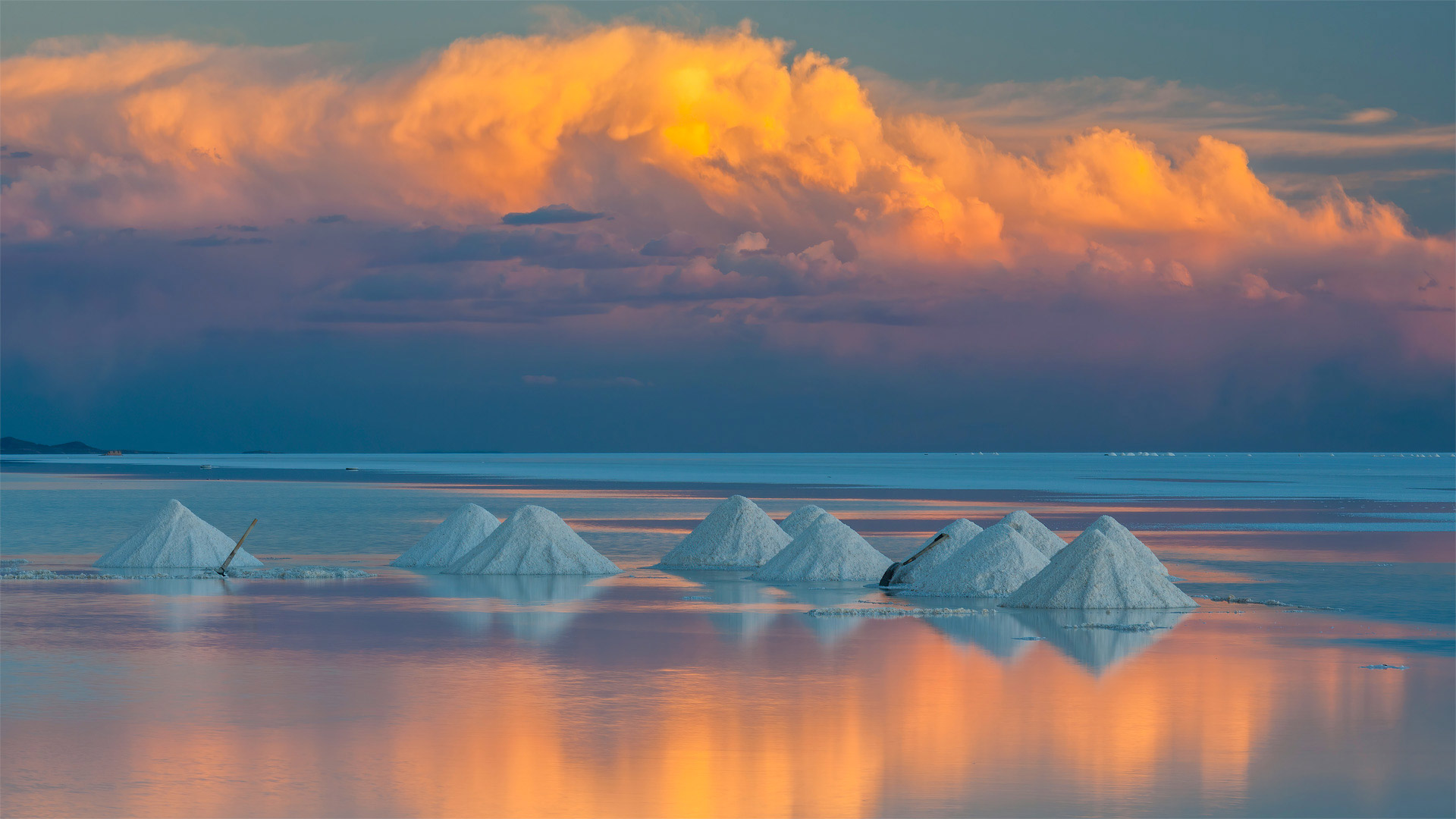
Salt of the earth
This shimmering white expanse could easily be mistaken for Antarctica. But what we're looking at isn't snow and ice—it's a surreal landscape of endless salt high in the Andes of southwest Bolivia. Located at a lofty altitude of about 12,000 feet above sea level, Salar de Uyuni is the world's largest salt flat (or salt pan), spanning just over 4,000 square miles. It was formed when prehistoric lakes dried up over centuries, leaving behind a desert of bright white salt that can be seen from space. During the rainy season (December to April), a thin layer of water covering the salt transforms the area into a giant mirror that reflects the beautiful Bolivian skies. If you're driving across the surface at such times, it can appear as though you are navigating through a highway of clouds.
Salar de Uyuni contains more than just a pinch of salt; there's an estimated 11 billion tons of it here, with about 25,000 tons extracted annually. Local salt gatherers—'saleros'—scoop the raw mineral into mounds to let it dry under the sun before it's transported to the nearby village of Colchani, where it's processed and turned into table salt, which is then sold in Bolivia and other countries. But the real treasure is buried beneath the salt crust: Just below the crystalline surface lies the world's largest untapped lithium reserve that could one day power the batteries in our smartphones, laptops, and electric cars.
盐的世界
这片闪闪发光的白色区域很容易被误认为是南极洲。但我们所看到的不是冰雪,而是玻利维亚西南部安第斯山脉的一片超现实的盐碱地。乌尤尼盐湖位于海拔约12000英尺的高空,是世界上最大的盐滩(或盐田),占地面积仅4000多平方英里。它是在史前湖泊干涸几个世纪后形成的,留下了一片从太空可以看到的亮白色盐沙漠。在雨季(12月至4月),覆盖在盐层上的一层薄薄的水将该地区变成一面巨大的镜子,反射玻利维亚美丽的天空。如果您在这样的时间驾驶车辆穿越地表,它可能看起来就像您正在穿越一条云层高速公路。
乌尤尼沙拉不仅仅含有一撮盐;这里估计有110亿吨石油,每年开采约25000吨。当地的盐业采集者“saleros”用铲子将未加工的矿物铲成土堆,在阳光下晾干,然后将其运到附近的科尔查尼村,在那里加工成食盐,然后在玻利维亚和其他国家出售。但真正的宝藏埋藏在盐壳之下:就在水晶表面之下,有世界上最大的尚未开发的锂储量,有朝一日可以为我们的智能手机、笔记本电脑和电动汽车的电池供电。
从索尔兹伯里的峭壁上俯瞰爱丁堡,苏格兰荷里路德公园 Salisbury Crags in Holyrood Park overlooking Edinburgh, Scotland (© Andrew Merry/Getty Images)
从索尔兹伯里的峭壁上俯瞰爱丁堡,苏格兰荷里路德公园 Salisbury Crags in Holyrood Park overlooking Edinburgh, Scotland (© Andrew Merry/Getty Images)
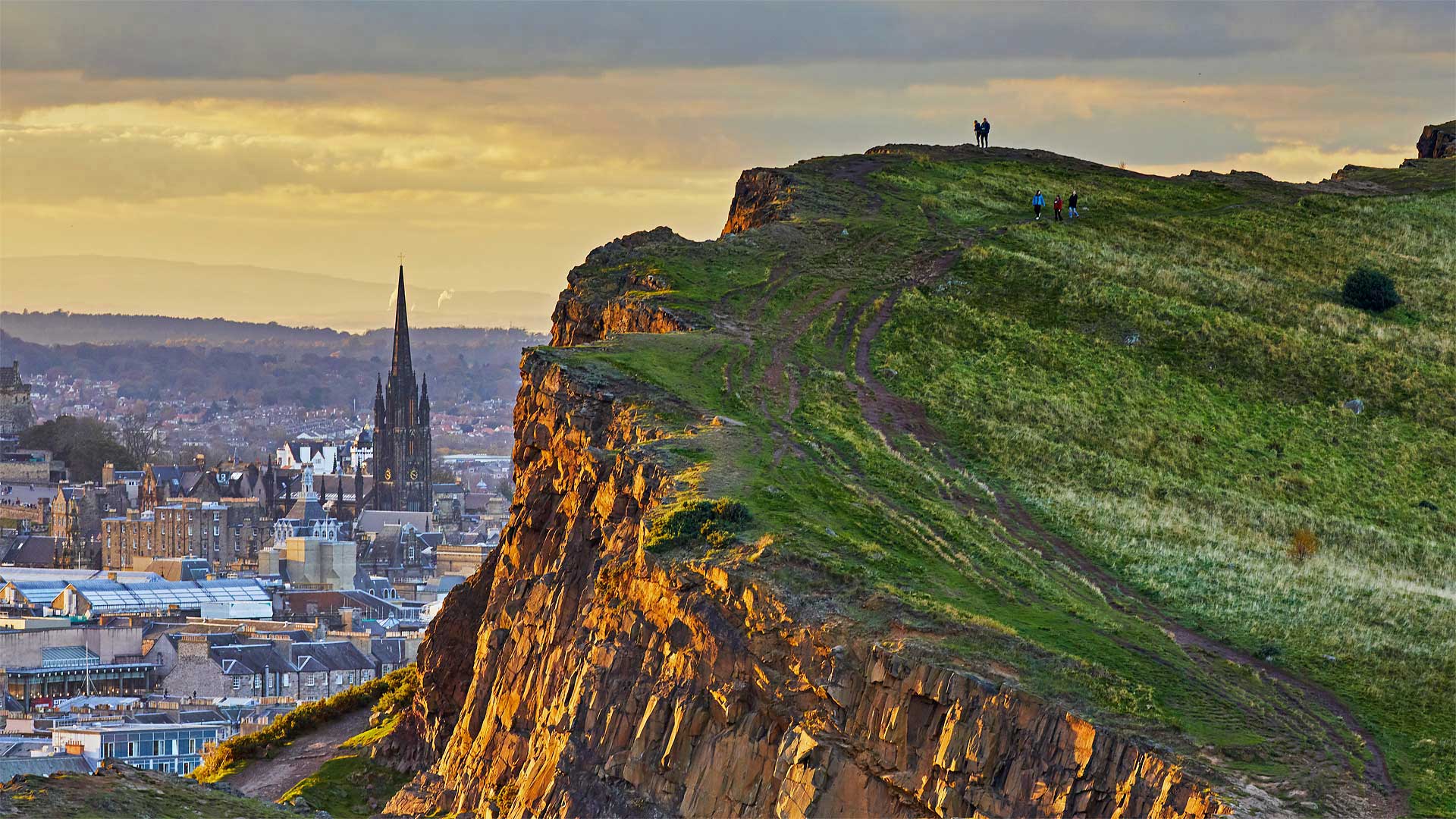
Looking down upon 'The Athens of the North'
We're kicking off festival season in Edinburgh, Scotland, with this view of the capital city from Salisbury Crags in Holyrood Park. Throughout the month of August, the city is hosting a staggering number of music, theater, opera, dance, and other types of performances as part of the Edinburgh International Festival and the Edinburgh Festival Fringe, which is the world's largest international arts festival.
Located less than a half-mile southeast from Edinburgh's main shopping street, Holyrood Park provides a welcome respite from the festival hubbub. Hike up here to take in views of Edinburgh and its famous landmarks, including Edinburgh Castle, the Scottish Parliament, Holyrood Palace, the City Centre, and the New Town, which stretches out toward the sea. Formed by glaciers and volcanic activity millions of years ago, these craggy outcroppings are among the best examples of a geological sill in Europe. We're lucky that they're still here for our hiking pleasure. For two centuries, the hard dolerite was mined, broken up and shipped off throughout the UK for use as cobblestoned streets. The locals put a stop to the mining and now we can stand here to take in the views—and during festival season if we listen closely, we may hear strains of music coming from somewhere down below.
俯瞰“北方的雅典”
我们将在苏格兰爱丁堡拉开节日的序幕,从Holyrood公园的索尔兹伯里峭壁上俯瞰首都。整个8月份,该市举办了数量惊人的音乐、戏剧、歌剧、舞蹈和其他类型的表演,作为爱丁堡国际艺术节和爱丁堡边缘艺术节的一部分,这是世界上最大的国际艺术节。
Holyrood公园位于爱丁堡主要购物街东南方向不到半英里的地方,为人们提供了一个从节日喧嚣中解脱出来的好去处。徒步来到这里,可以欣赏爱丁堡及其著名的地标性建筑,包括爱丁堡城堡、苏格兰议会、霍利罗德宫、市中心和伸向大海的新城。由数百万年前的冰川和火山活动形成,这些崎岖的露头是欧洲地质岩床的最好例子之一。我们很幸运,他们还在这里是为了我们的徒步旅行。两个世纪以来,硬辉绿岩被开采、破碎并运往英国各地,用作鹅卵石街道。当地人停止了采矿,现在我们可以站在这里欣赏风景。在节日期间,如果我们仔细聆听,我们可能会听到下面某处传来的音乐。
大使馆花园的空中游泳池, 英国伦敦 The Sky Pool at Embassy Gardens in London, England (© Xinhua News Agency/Getty Images)
大使馆花园的空中游泳池, 英国伦敦 The Sky Pool at Embassy Gardens in London, England (© Xinhua News Agency/Getty Images)
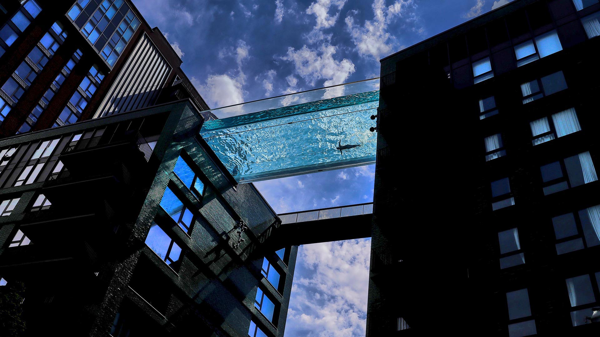
A swim in the sky
A lap in this 'sky pool' may have you holding your breath, and not just because you're underwater. With the streets of London looming 10 stories down, the view through the pool's clear bottom is a bit freaky to all but the fearless. But swimming here is a one-of-a-kind experience, and for some lucky residents of these twin apartment blocks near the US Embassy, a convenient way to pop in on neighbors the next building over.
The pool is suspended 115 feet in the air, but its origin is even loftier: It was manufactured at 4,600 feet in the good ol' USA—Grand Junction, Colorado, to be precise—then shipped across the pond to its new home in sea-level London.
在空中游泳
在这个“空中游泳池”里跑一圈可能会让你屏住呼吸,而不仅仅是因为你在水下。随着10层楼高的伦敦街道隐约可见,游泳池清澈见底的景色对于除了无所畏惧的人以外的所有人来说都有点怪异。但在这里游泳是一种独一无二的体验,对于美国大使馆附近这两栋公寓楼的一些幸运居民来说,这是一种方便的方式,可以顺便拜访隔壁的邻居。
游泳池悬挂在115英尺的空中,但它的起源更为崇高:它是在4600英尺高的科罗拉多州的古德奥美大枢纽(good ol’USA Grand Junction)制造的,准确地说,然后穿过游泳池运到它位于海平面伦敦的新家。
波白克岛的小尖塔岩石,英格兰多塞特 (© James Osmond/Alamy)
蒙特城堡,意大利普利亚大区 Castel del Monte, Apulia, Italy (© Toni Spagone/Alamy)
蒙特城堡,意大利普利亚大区 Castel del Monte, Apulia, Italy (© Toni Spagone/Alamy)
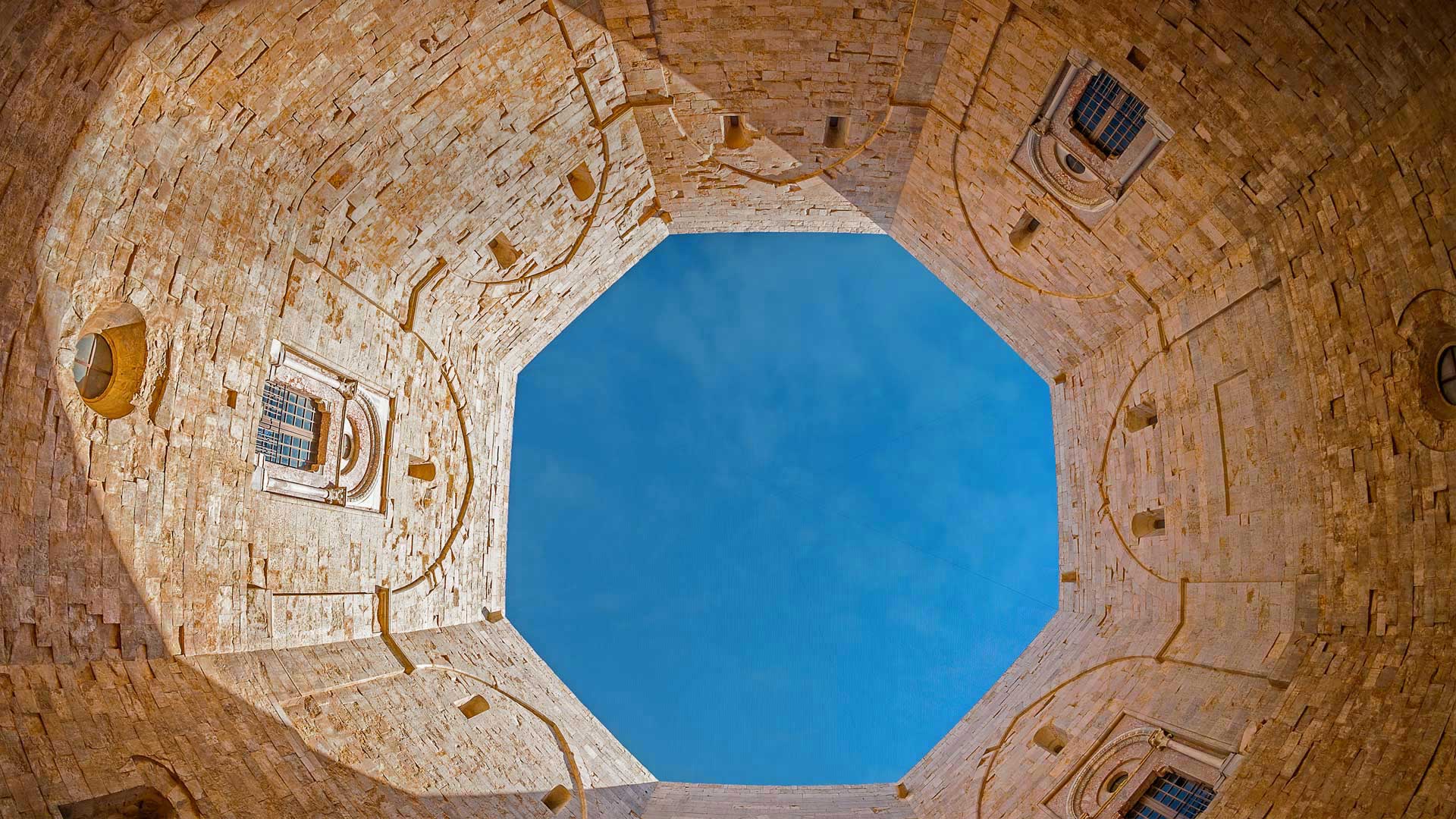
An octagonal architectural treasure
Built in the 1240s by the Holy Roman Emperor Frederick II in southeast Italy, Castel del Monte (Castle of the Mount) features an unusual octagonal design. Eight stone walls stretch between eight octagonal towers and enclose an octagonal courtyard. Each of the two floors also has eight trapezoidal rooms. Acclaimed and protected as a World Heritage Site in 1966, the castle symbolically reflects a harmonious integration of classical Roman, Arabic, and medieval architecture and design—and to some, its octagonal symmetry suggests a connection between heaven and earth.
Its original purpose is unclear. Without a drawbridge, moat, or curtain wall to protect it, it was clearly not a defensive fortress, and its lack of stables call into question its function as a hunting lodge. Over the centuries it has served as a prison and as a refuge from the plague. But whatever the emperor's intention, he left a captivating monument that still enchants today.
八角形建筑瑰宝
蒙特城堡(山上城堡)建于1240年代,由神圣罗马皇帝腓特烈二世在意大利东南部建造,具有不同寻常的八角形设计。八堵石墙在八座八角形塔楼之间延伸,围绕着一个八角形庭院。两层楼各有八个梯形房间。1966年,这座城堡被誉为世界遗产,并受到保护。它象征性地反映了古典罗马、阿拉伯和中世纪建筑与设计的和谐结合,对某些人来说,它的八角对称性暗示着天地之间的联系。
其最初目的尚不清楚。由于没有吊桥、护城河或幕墙的保护,它显然不是一个防御堡垒,而且它没有马厩,这使它作为狩猎小屋的功能受到质疑。几个世纪以来,它一直被用作监狱和躲避瘟疫的避难所。但不管皇帝的意图是什么,他留下了一座迷人的纪念碑,至今仍令人着迷。
圆顶礁国家公园的大教堂谷,犹他州 Mesas, Upper Cathedral Valley, Capitol Reef National Park, Utah (© Tim Fitzharris/Minden Pictures)
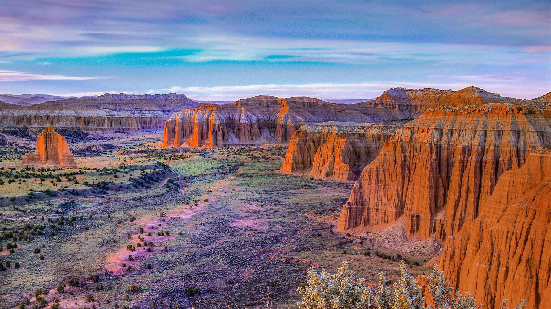
圆顶礁国家公园的大教堂谷,犹他州 Mesas, Upper Cathedral Valley, Capitol Reef National Park, Utah (© Tim Fitzharris/Minden Pictures)
This 'reef' is nowhere near the sea…
…nor the US Capitol building it's named for. Utah's Capitol Reef National Park—first established as a national monument this day in 1937—is named for its massive rock domes that reminded explorers of that famous rotunda back in Washington, DC. Why Capitol 'Reef,' though? Because the imposing formations were a major obstacle to travelers through the region, the same way a coral reef is an obstacle to sailors.
This section of the park, Cathedral Valley, is dotted with monoliths that differ from the namesake domes, instead featuring sheer, jagged walls. While most of the park rests on a steeply warped section of Earth's crust, Cathedral Valley is relatively flat—so rather than carving out gently sloping domes, water erosion here has tended to cut deep, narrow recesses down the rock faces.
这个“暗礁”离海很远…
…也不是以它命名的美国国会大厦。犹他州国会珊瑚礁国家公园于1937年作为国家纪念碑首次建立,以其巨大的岩石圆顶命名,使探险家们想起了华盛顿特区著名的圆形大厅。但为什么国会大厦是“暗礁”?因为壮观的地形是旅行者穿越该地区的主要障碍,就像珊瑚礁是海员的障碍一样。
公园的这一部分,即大教堂谷,点缀着不同于同名圆顶的巨石,取而代之的是陡峭、参差不齐的墙壁。虽然公园的大部分都坐落在地壳急剧弯曲的部分,但大教堂山谷相对平坦,因此这里的水侵蚀倾向于沿着岩石表面切割出深而窄的凹坑,而不是雕刻出缓倾斜的圆顶。
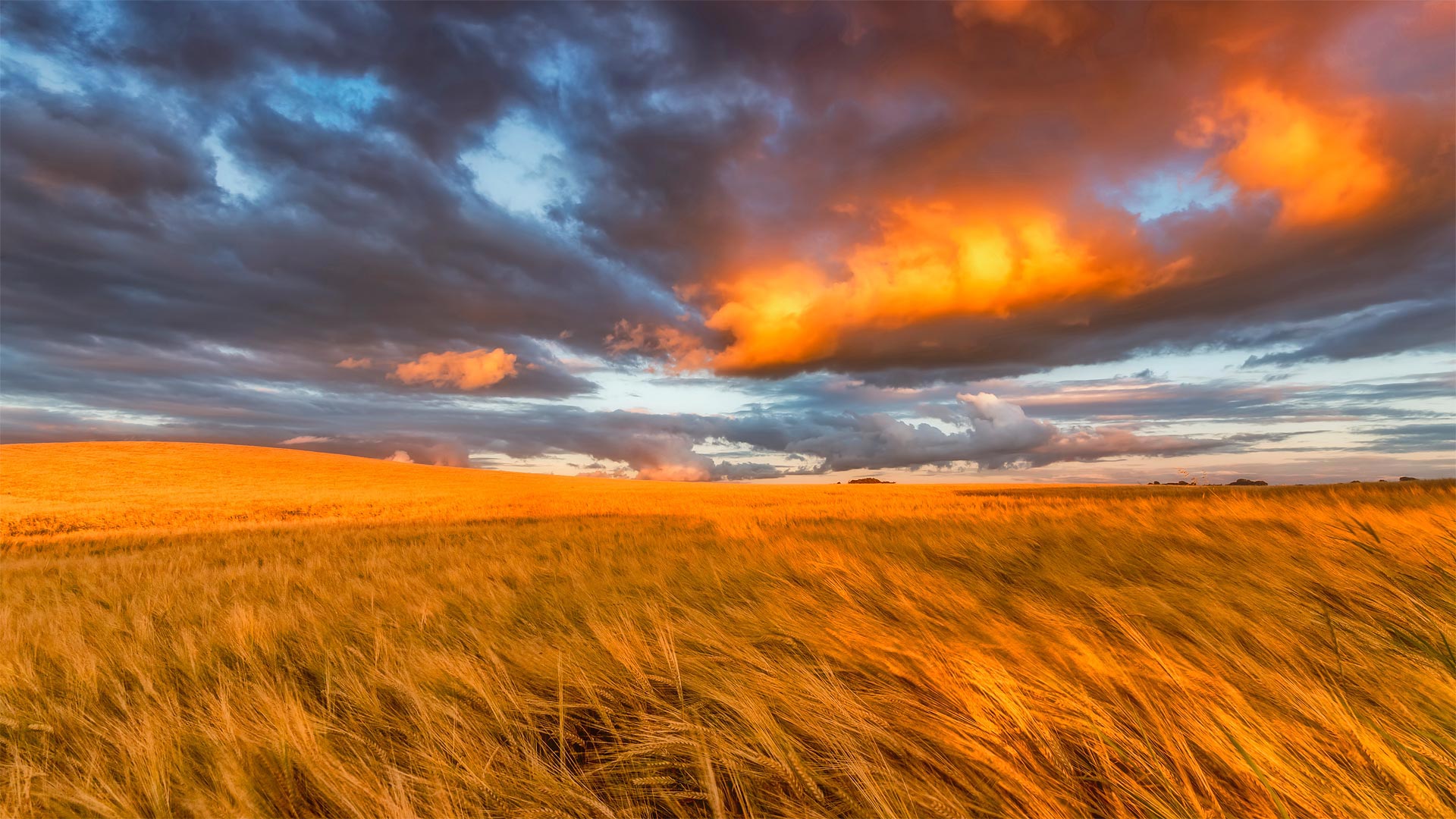
东洛锡安的金黄麦田,苏格兰 Barley field in East Lothian, Scotland (© Scott Masterton/plainpicture)
东洛锡安的金黄麦田,苏格兰 Barley field in East Lothian, Scotland (© Scott Masterton/plainpicture)
Welcome to Scotland's garden
Today, we're in the 'Garden of Scotland,' better known as the East Lothian region, to pay homage to the area's agricultural roots on Lammas Day. Also known as Loaf Mass Day, it's an observance that marks the beginning of the harvest season and is traditionally celebrated on August 1. The holiday is descended from the ancient British tradition known during the Middle Ages as the Gule of August and was gradually incorporated into the Christian liturgy celebrating Holy Communion. It gets its name from loaves of bread baked from the first harvested grain of the season each year.
Traditionally, Lammastide festivals would mean up to 10 days of raucous eating, drinking, and general merriment. Scottish couples could also take advantage of another common practice during a Lammas fair: a trial marriage, or 'handfast,' where a young couple could live together for a trial period that could last as long as the Lammas festival itself, or even up to a full year. If at the end of the trial the couple decided to call things off, the woman could return to her family with all of her possessions. If a child was born from this union, it would go live with the father without stigma. And while this arrangement seems awfully modern, it was likely just a consequence of a lack of priests—handfasts allowed a single traveling priest to perform all the town's weddings in one day.
欢迎来到苏格兰花园
今天,我们来到了“苏格兰花园”,更著名的是东洛锡安地区,在南丫岛日向该地区的农业根源致敬。也被称为面包弥撒日,这是一个标志着收获季节开始的节日,传统上在8月1日庆祝。这个节日起源于中世纪英国古老的传统,被称为八月红色,并逐渐融入基督教庆祝圣餐的礼拜仪式中。它的名字来源于每年收获的第一批谷物烘焙的面包。
传统上,Lammatide节日将意味着长达10天的喧闹的饮食和一般的欢乐。苏格兰夫妇还可以利用拉玛节期间的另一种常见做法:试婚,或“禁手”,年轻夫妇可以在一起生活一段试婚期,这段试婚期可能与拉玛节本身一样长,甚至长达一整年。如果在庭审结束时,这对夫妇决定取消婚约,这名妇女可以带着她所有的财产回到家中。如果一个孩子是从这种结合中出生的,那么他将与父亲生活在一起,没有任何耻辱感。虽然这种安排看起来非常现代,但很可能只是因为缺少牧师的手铐,一个旅行的牧师可以在一天内完成镇上所有的婚礼。
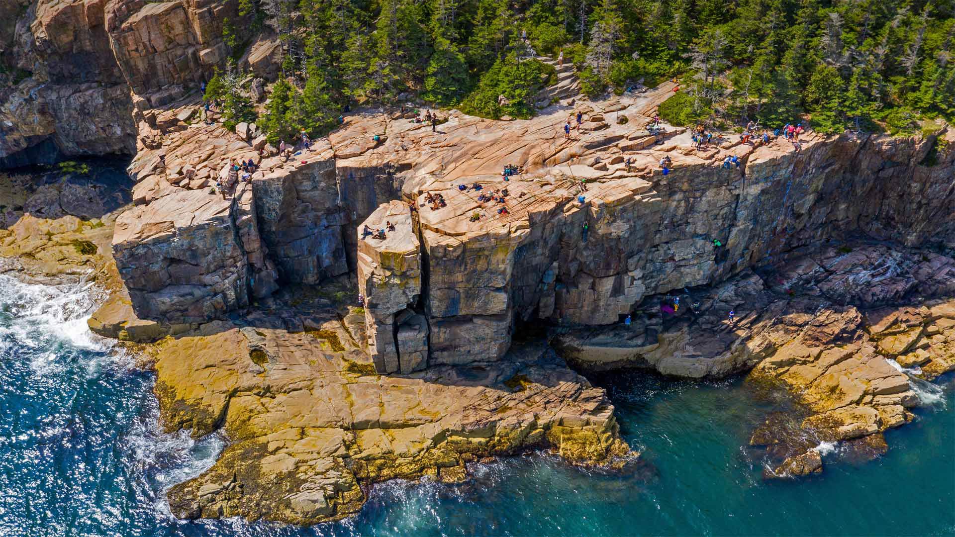
阿卡迪亚国家公园里的水獭悬崖,缅因州 Otter Cliffs, Acadia National Park, Maine (© dbimages/Alamy)
阿卡迪亚国家公园里的水獭悬崖,缅因州 Otter Cliffs, Acadia National Park, Maine (© dbimages/Alamy)
Working for that cliffside view
Maine's Acadia National Park serves up spectacular views at most every turn. But the park's Otter Cliffs on Mount Desert Island offer the adventurous among us a chance to take in the picturesque Atlantic shoreline from the edge of a sheer granite wall. Rising some 60 feet above the crashing waves below, the cliffs are shown here at low tide—when the tide is up, that ledge at the bottom is completely submerged.
The spot's become one of New England's premier climbing destinations, with routes beloved by experts and beginners alike. Climbers begin by either rappelling down the cliff or being lowered from the top. The heart races at the bottom, as waves crash against the seawall right below the climber's shoes and ocean spray makes the first few hand- and footholds slippery. From there, the only way out is up, back to the top of this stunning crag and the cap to a thrilling ascent.
在悬崖边工作
缅因州的阿卡迪亚国家公园最多在每个转弯处都能看到壮观的景色。但公园位于荒山岛上的水獭悬崖为我们中的冒险者提供了一个从陡峭的花岗岩墙边缘欣赏风景如画的大西洋海岸线的机会。这些悬崖高出下面汹涌的海浪约60英尺,在低潮时,当涨潮时,悬崖底部的岩壁完全被淹没。
该景点已成为新英格兰首要的登山目的地之一,其路线深受专家和初学者的喜爱。攀岩者一开始要么从悬崖上攀爬下来,要么从山顶往下爬。当海浪拍打着登山者鞋下的海堤时,心脏在底部跳动,海水的浪花使最初的几个手和脚点变得很滑。从那里出发,唯一的出路就是爬上,回到这座令人惊叹的峭壁的顶端,再爬上令人激动的山峰。
密歇根湖畔的阿德勒天文馆, 芝加哥伊利诺伊州 Adler Planetarium near Lake Michigan, Chicago, Illinois (© Amazing Aerial Agency/Offset by Shutterstock)
密歇根湖畔的阿德勒天文馆, 芝加哥伊利诺伊州 Adler Planetarium near Lake Michigan, Chicago, Illinois (© Amazing Aerial Agency/Offset by Shutterstock)
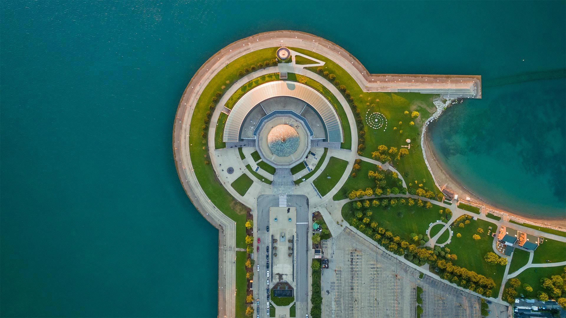
America's oldest planetarium
When it first flicked on the projector lights in 1930, the Adler Planetarium in Chicago was the only one in the Western Hemisphere. At the time, planetariums themselves were only a 7-year-old invention imported from German lens grinders. But the American public's fascination with stars and distant worlds, it turned out, was skyrocketing. By 1934, the Adler had welcomed over a million visitors.
And though our love for space endures, these days in Chicagoland it's tough to catch a clear night sky past all those wonderful bright lights of the Windy City. That helps explain why the Adler still pulls half a million visitors in a typical year, with three state-of-the-art auditoriums and even a massive telescope that lets visitors view far-off galaxies.
美国最古老的天文馆
1930年,芝加哥的阿德勒天文馆(Adler Planetarium)第一次打开投影仪的灯光时,是西半球唯一的天文馆。当时,天文馆本身只是从德国镜头研磨机进口的一项7年发明。但事实证明,美国公众对星星和遥远世界的迷恋正在飙升。到1934年,阿德勒号已经接待了超过一百万的游客。
尽管我们对太空的热爱永存,但如今在芝加哥,要想在这座多风的城市里捕捉到一片晴朗的夜空是很困难的。这有助于解释为什么阿德勒号在一个典型的年份里仍然吸引了50万游客,有三个最先进的礼堂,甚至还有一个巨大的望远镜,可以让游客观看遥远的星系。
乌鲁鲁艺术家布鲁斯·蒙罗的《光之领域》, 澳大利亚 'Field of Light' by artist Bruce Munro at Uluru, Australia (© Sheralee Stoll/Alamy
乌鲁鲁艺术家布鲁斯·蒙罗的《光之领域》, 澳大利亚 'Field of Light' by artist Bruce Munro at Uluru, Australia (© Sheralee Stoll/Alamy)
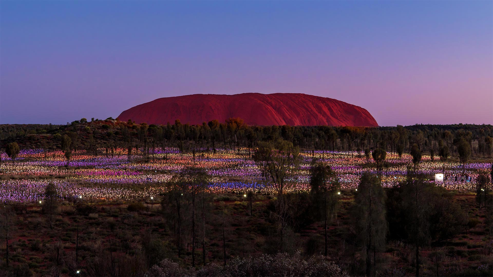
Illuminated Uluru
This landmark of the Land Down Under is usually pictured in sweltering desert sunlight. Now a 21st-century addition near the ancient rock of Uluru has people flocking here even at night.
Bruce Munro's 'Field of Light' installations—which blanket landscapes in thousands of small LED lights—have appeared around the globe, first in the artist's native England. But it was decades ago while camping here at Uluru that Munro first had the idea for an immersive artwork that would bathe its surroundings in soft light nightly, like desert flowers that bloom after dusk in the Australian Outback. Munro was finally able to bring 'Field of Light' to this forest near Uluru in 2016, and it became so popular with visitors that it's been extended indefinitely.
照明乌鲁鲁
下面这片土地的地标通常是在闷热的沙漠阳光下拍摄的。现在,在乌鲁鲁古岩附近的一个21世纪的新建筑里,人们甚至在晚上都聚集在这里。
布鲁斯·蒙罗的“光的领域”装置覆盖了数千个小型LED灯的景观,出现在世界各地,首先是在艺术家的祖国英格兰。但几十年前,蒙罗在乌鲁鲁露营时,第一次想到了一件身临其境的艺术品,每晚都能沐浴在柔和的光线中,就像澳大利亚内陆黄昏后盛开的沙漠花朵。蒙罗终于在2016年将“光之场”带到了乌鲁鲁附近的这片森林,它受到了游客的欢迎,因此被无限期地延长了。