梅加拉亚邦的七姐妹瀑布,印度 Nohsngithiang Falls in Meghalaya, India (© Upamanyoo Das/Shutterstock)
梅加拉亚邦的七姐妹瀑布,印度 Nohsngithiang Falls in Meghalaya, India (© Upamanyoo Das/Shutterstock)
India Nohsngithiang Falls
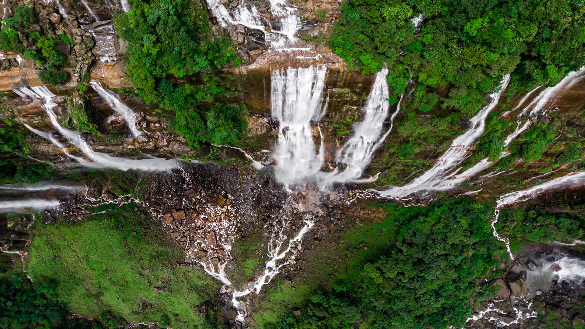
Nohsngithiang Falls is a picturesque waterfall located south of Mawsmai village in East Khasi Hills district in Meghalaya, India. The waterfalls from a height of 315 metres (1,033 ft), segmented into seven different sections, giving it the epithet of the Seven Sisters Waterfalls. As the name suggests, it has seven different waterfalls that are strategically arranged side by side on a high, rugged cliff, and they look compelling even from a distance. The scintillating waterfall is seasonal and plunges over the limestone-covered hills only during the monsoon.
Nohsngithiang Falls is symbolic of the seven sister states of Northeast India namely Assam, Arunachal Pradesh, Manipur, Nagaland, Tripura, Mizoram, and Meghalaya. The waterfall cannot be entered into but creates a spectacular viewpoint that can be seen from nearby bridges and sheds. The beauty of the waterfall is indescribable during sunset when the rays of the sun fall on it creating a perennial rainbow, which is also one of the major highlights of the place.
印度诺兴钦瀑布
Nohsngitiang瀑布是一个风景如画的瀑布,位于印度Meghalaya东Khasi Hills区Mawsmai村南部。瀑布的高度为315米(1033英尺),分为七个不同的部分,被称为七姐妹瀑布。顾名思义,它有七个不同的瀑布,从战略上讲,它们并排排列在一个高而崎岖的悬崖上,即使从远处看,它们也是引人注目的。闪烁的瀑布是季节性的,只有在季风季节才会在石灰岩覆盖的山丘上俯冲。
Nohsngithiang Falls象征着印度东北部的七姐妹州,即阿萨姆、阿鲁纳恰尔邦、曼尼普尔、Nagaland、特里普拉、米佐拉姆邦和梅加拉亚邦。瀑布无法进入,但创造了一个壮观的观点,可以从附近的桥梁和棚屋看到。日落时,阳光照射在瀑布上,形成了一道经久不衰的彩虹,这也是这个地方的主要亮点之一,瀑布的美丽是无法形容的。
坎伯兰岛国家海岸,美国佐治亚州 Cumberland Island National Seashore, Georgia (© Wilsilver77/Getty Images Plus)
坎伯兰岛国家海岸,美国佐治亚州 Cumberland Island National Seashore, Georgia (© Wilsilver77/Getty Images Plus)
Cumberland Island National Seashore
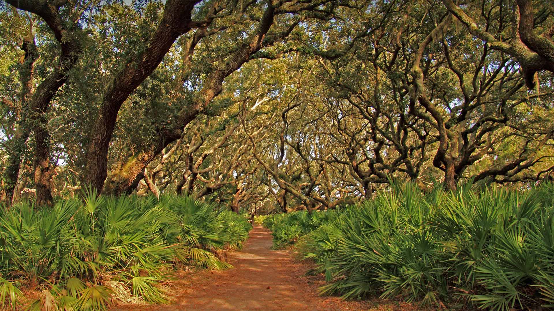
Along the southernmost stretch of Georgia's Atlantic coast are several barrier islands, and Cumberland is the largest. The US National Park Service (NPS) protects 9,800 acres of the island's wilderness, a place where, as the NPS says, nature and history meet. Human occupation on Cumberland Island touches on numerous milestones in the story of America.
Eventually, Cumberland became a vacation getaway for wealthy industrialists in the 20th century before it became a protected public land.
The natural beauty of the island's maritime forests and marshes add to Cumberland's unique charm. And a lush ecosystem supports the island's diverse array of wildlife, including armadillos, alligators, and herds of feral horses.
州坎伯兰海岸国家公园
沿着乔治亚州大西洋海岸最南端有几个屏障岛,坎伯兰岛是最大的。美国国家公园管理局(NPS)保护着岛上9800英亩的荒野,正如NPS所说,这里是自然和历史交汇的地方。坎伯兰岛上的人类占领涉及到美国历史上的许多里程碑。
最终,坎伯兰在成为受保护的公共土地之前,在20世纪成为富有实业家的度假胜地。
岛上海洋森林和沼泽的自然美景增添了坎伯兰独特的魅力。繁茂的生态系统支撑着岛上各种各样的野生动物,包括犰狳、短吻鳄和成群的野马。
悬崖上雕刻的古老岩石墓葬,土耳其达利安附近 Ancient rock tombs carved into the cliff near Dalyan, Turkey (© Reinhard Schmid/eStock Photo)
悬崖上雕刻的古老岩石墓葬,土耳其达利安附近 Ancient rock tombs carved into the cliff near Dalyan, Turkey (© Reinhard Schmid/eStock Photo)
Turkey, Ancient rock tombs
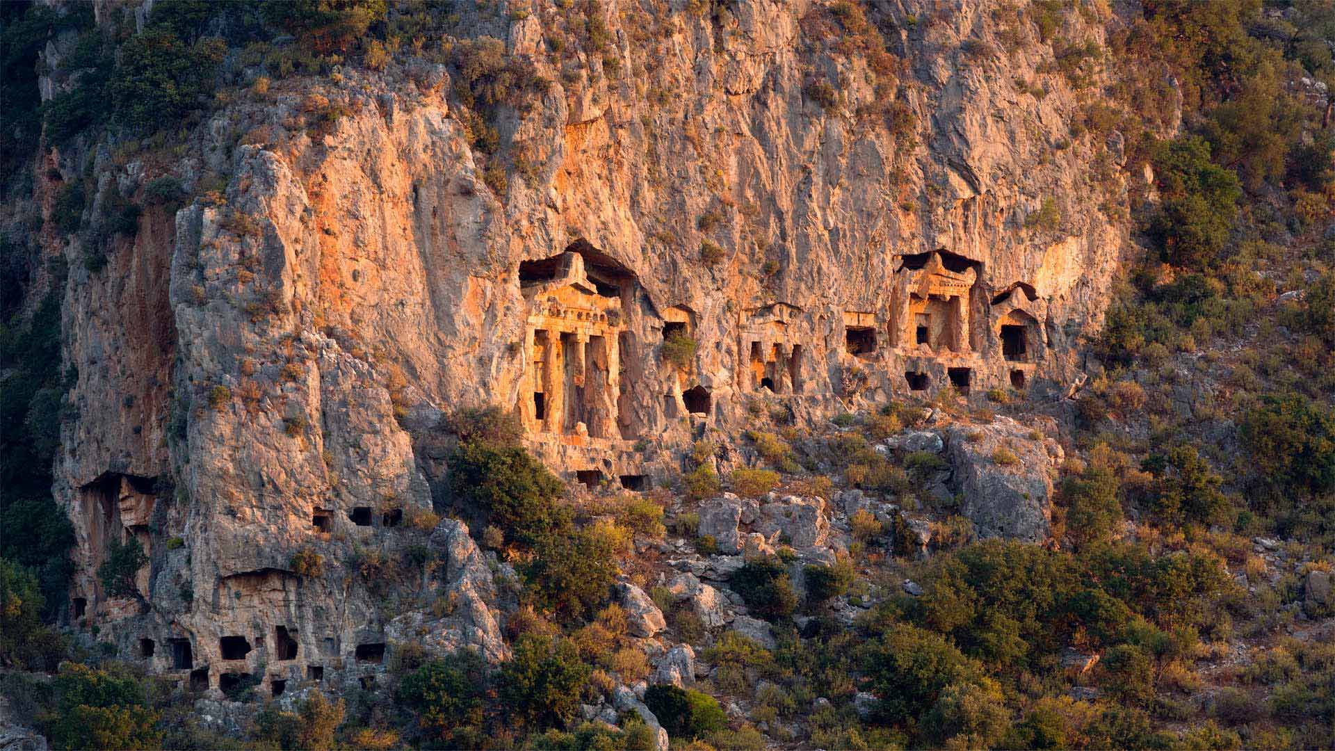
Among the remains of the ancient Anatolian port city of Kaunos are these carvings in the sheer rock walls above the Dalyan Çayı River. Overlooking the modern-day city of Dalyan, Turkey, what appear to be ornate cliff dwellings are really the weathered facades of tombs for the elite of a once-forgotten society.
With a history of human habitation going back almost 3,000 years, Kaunos has over the centuries found itself under Persian, Greek, Persian (again), Macedonian, Roman, Lycian, Roman (again), and finally Turkish rule—just to give you the highlights. But it was the sands of time that conquered the city once and for all: Silty deposits from the river eventually mucked up the port so badly it became useless. Gradually abandoned, Kaunos' location was lost to memory, and its rock-hewn Lycian tombs, monuments, and 5,000-seater amphitheater were relegated to rumor until a British surveyor rediscovered the site in 1842.
土耳其,古岩墓
在古老的安纳托利亚港口城市卡乌诺斯的遗迹中,有这些雕刻在达利安ı河上方陡峭的岩壁上。俯瞰土耳其现代城市Dalyan,看似华丽的悬崖住宅实际上是一个曾经被遗忘的社会精英们的坟墓风化的正面。
Kaunos的人类居住历史可以追溯到近3000年前,几个世纪以来,它一直处于波斯人、希腊人、波斯人(再次)、马其顿人、罗马人、利西亚人、罗马人(再次)以及最后的土耳其统治之下,这只是为了给你一个亮点。但是,正是时间的沙粒一劳永逸地征服了这座城市:河流中的淤泥沉积物最终把港口弄得一团糟,变得毫无用处。卡诺斯的位置逐渐被遗弃,人们对其失去了记忆,其岩石凿成的利西亚陵墓、纪念碑和5000座的圆形剧场也被流言传开,直到1842年一名英国勘测员重新发现该地点。
日出时的麦克拱岩,俄勒冈南海岸 Mack Arch Rock at sunrise on the southern Oregon coast (© Dennis Frates/Alamy)
日出时的麦克拱岩,俄勒冈南海岸 Mack Arch Rock at sunrise on the southern Oregon coast (© Dennis Frates/Alamy)
Southern Oregon coast, Mack Arch Rock
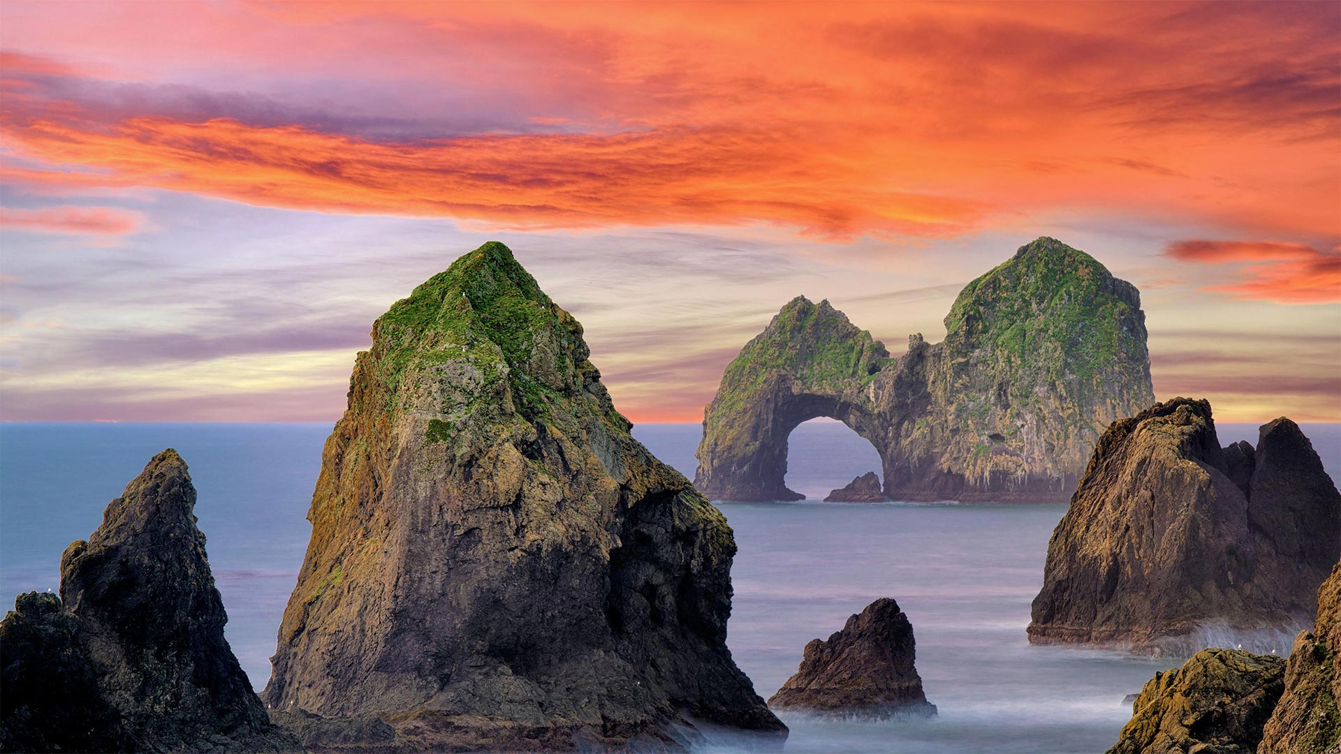
One of the common sights along the Oregon coast are the colossal rock formations known as sea stacks that jut from the Pacific and form an indelible, craggy imprint in your memory. The sea stacks you see here run next to a grassy promontory in the southern part of the state that overlooks a mostly inaccessible stretch of coastline.
In the background of this image is the Mack Arch, one of the largest naturally formed arches on the Pacific Coast and part of the Mack Reef archipelago. These clusters of sea stacks and beaches are home to a large concentration of seabirds like cormorants, black oystercatchers, gulls, and murres, as well as harbor seals and other marine wildlife. To help preserve this pristine sanctuary, the US Fish & Wildlife Service has designated it part of the Oregon Islands National Wildlife Refuge and closed the area off to the public. So have the owners of all the privately-owned land and beach that surround the refuge. So, if you're looking to get a close-up view of Mack Arch, your best bet is to do so by plane or boat.
俄勒冈州南部海岸,Mack Arch Rock
俄勒冈州海岸的一个常见景观是巨大的岩层,被称为海垛,它们从太平洋伸出,在你的记忆中形成一个不可磨灭、崎岖不平的印记。你在这里看到的海垛位于该州南部的一个长满青草的海角旁,俯瞰着一段几乎无法到达的海岸线。
这张图片的背景是麦克拱门,它是太平洋海岸最大的自然形成的拱门之一,也是麦克礁群岛的一部分。这些成簇的海垛和海滩是鸬鹚、黑牡蛎捕手、海鸥和海鸥等海鸟以及海豹和其他海洋野生动物的聚集地。为了帮助保护这个原始的保护区,美国鱼类和野生动物服务局已将其指定为俄勒冈群岛国家野生动物保护区的一部分,并对公众关闭了该区域。避难所周围所有私有土地和海滩的所有者也是如此。所以,如果你想近距离观察马克拱门,最好是坐飞机或船。
帕尔默河上的红桥,加拿大魁北克省 Pont Rouge (Red Bridge) over the Palmer River in Sainte-Agathe-de-Lotbinière, Quebec, Canada (© Jean Surprenant/Getty Images)
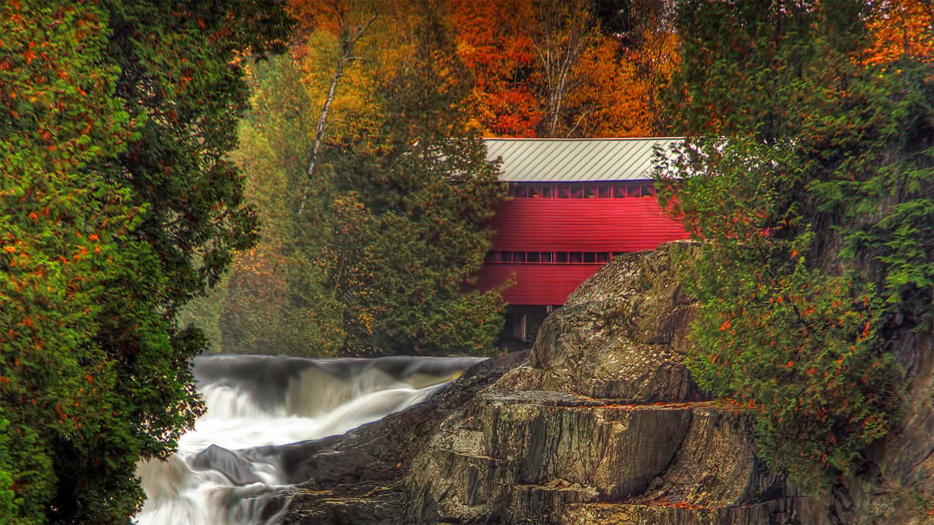
帕尔默河上的红桥,加拿大魁北克省 Pont Rouge (Red Bridge) over the Palmer River in Sainte-Agathe-de-Lotbinière, Quebec, Canada (© Jean Surprenant/Getty Images)
Canada, Quebec Red Bridge
When the Pont Rouge (Red Bridge) of Sainte-Agathe-de-Lotbinière was built over the Palmer River in 1928, covered bridges were already commonplace here in Quebec. Simple designs imported from the United States allowed relatively untrained workers to quickly construct crossings like this. 'Ponts rouges' (often called this whether or not they were painted red) popped up wherever rural French Canadians required a convenient river crossing—as many as 1,500 were built between the late 1800s and the 1950s. Today fewer than 100 still stand, and some—like this one—are protected by local and provincial agencies for historic preservation.
加拿大魁北克红桥
1928年,圣阿加泰德·洛比尼埃的红桥(Pont Rouge)在帕尔默河上修建时,盖梁桥在魁北克已经司空见惯。从美国进口的简单设计允许相对未经培训的工人快速建造这样的过境点19世纪末至20世纪50年代,在法裔加拿大人需要方便的河流穿越的地方,就出现了红桥(无论是否被漆成红色,通常称之为红桥),修建了多达1500座。今天,只有不到100个仍然存在,像这一个这样的一些是由地方和省级机构保护的历史保护。
排灯节上点亮的灯笼, 印度孟买 Lanterns illuminated for the Diwali festival, Mumbai, India (© RAMNIKLAL MODI/Shutterstock)
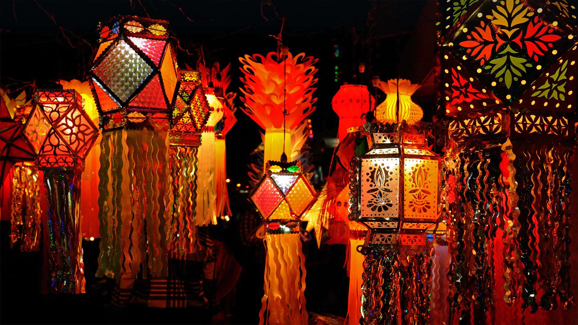
排灯节上点亮的灯笼, 印度孟买 Lanterns illuminated for the Diwali festival, Mumbai, India (© RAMNIKLAL MODI/Shutterstock)
Diwali Festival
Diwali is a five-day celebration of the symbolic victory of light over darkness, good over evil, and knowledge over ignorance. Though Diwali is one of the most important festivals of the Hindu faith, it is also embraced by Sikhs, Jains, and even some Buddhists. Celebrants often decorate their homes with oil lamps called diyas and create colorful patterns on the floor known as rangolis. Streets, markets, temples, and other public spaces are also illuminated with hanging lanterns like those seen in our homepage photo.
Each day of the festival has its own significance, but day three—called Lakshmi Pujan—is considered the main event. Lakshmi is the Hindu goddess of wealth. To prepare for Lakshmi Pujan, people clean their homes to welcome Lakshmi's blessings of prosperity and happiness. Diwali celebrations in 2021 last until November 6, so there's still time to embrace the light.
排灯节
排灯节是为期五天的庆祝活动,象征着光明战胜黑暗,善良战胜邪恶,知识战胜无知。虽然排灯节是印度教信仰中最重要的节日之一,但锡克教徒、耆那教徒甚至一些佛教徒也喜欢排灯节。庆祝者经常用油灯装饰他们的家,油灯被称为diyas,并在地板上创造出五颜六色的图案,称为rangolis。街道、市场、庙宇和其他公共空间也会像我们主页上的照片一样悬挂着灯笼。
节日的每一天都有它自己的意义,但被称为Lakshmi Pujan的第三天被认为是主要活动。拉克希米是印度的财富女神。为了准备Lakshmi Pujan,人们清洁他们的家园,欢迎Lakshmi繁荣和幸福的祝福。2021年排灯节的庆祝活动一直持续到11月6日,所以还有时间拥抱光明。
托利莫尔森林公园的弗利桥,英国北爱尔兰 (© Adrian McGlynn/Alamy)
海月水母和一群无刺的黄金水母,印度尼西亚 Moon jelly and an aggregation of stingless golden jellyfish in a landlocked marine lake, Raja Ampat, West Papua, Indonesia (© Alex Mustard/Minden Pictures)
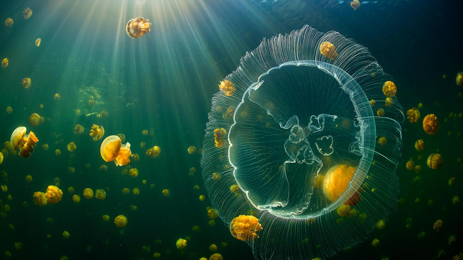
海月水母和一群无刺的黄金水母,印度尼西亚 Moon jelly and an aggregation of stingless golden jellyfish in a landlocked marine lake, Raja Ampat, West Papua, Indonesia (© Alex Mustard/Minden Pictures)
World Jellyfish Day
Today we're celebrating World Jellyfish Day—even though these creatures are best described as otherworldly. Despite their alien qualities (not to mention their inability to vocalize), jellyfish have a lot to say to us about the history of life on Earth.
For example, species like the moon jelly and smaller golden jellies in our picture possess primitive eyes that only detect the presence of light, like the nourishing sunbeams they're chasing here. But some of their cousins, like the box jellyfish, boast several complex eyes with corneas and retinas. These differences help biologists understand how the human eye evolved to process such dazzling spectacles as the jellyfish's delicate dance.
世界水母日
今天我们要庆祝世界水母日,尽管这些生物被形容为超凡脱俗的。尽管水母有着异族的特质(更不用说它们不会发声),但它们对地球上的生命史有着很多的看法。
例如,在我们的照片中,像月亮果冻和较小的金色果冻这样的物种拥有原始的眼睛,它们只能探测到光线的存在,就像它们在这里追逐的滋养阳光一样。但是他们的一些表亲,比如盒子水母,拥有几只复杂的眼睛,有角膜和视网膜。这些差异有助于生物学家了解人类眼睛是如何进化来处理水母微妙的舞蹈等令人眼花缭乱的景象的。
亡灵节上点缀公墓的万寿菊,墨西哥米却肯州 (© Irwin Barrett/Design Pics/Alamy)
薄雾笼罩的松树林,越南 Misty pine forest in the Central Highlands of Vietnam (© Thanh Thuy/Moment/Getty Images)
薄雾笼罩的松树林,越南 Misty pine forest in the Central Highlands of Vietnam (© Thanh Thuy/Moment/Getty Images)
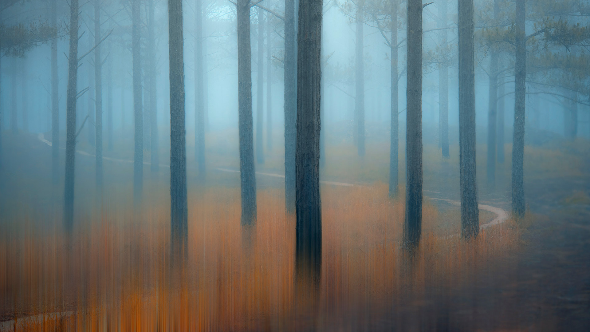
Misty Pine Forest
The woods are a tranquil place, but can be scary for a lone wanderer. Out here, you could suddenly find yourself running from the big bad wolf, escaping a witch's clutches, or just plain old lost. Though often in the old stories, scary places like this are also where the hero overcomes a great obstacle or finds a valuable treasure. Could you be in luck?
The spindly pine forests of the Central Highlands of Vietnam, shown here, are the setting for many traditional tales of evil spirits and spells. But even if you don't believe in all that magic stuff, a forest can still feel enchanted when twilight bathes the misty air. Just don't lose your way out here…
雾松林
森林是一个宁静的地方,但对一个孤独的流浪者来说却很可怕。在这里,你可能会突然发现自己在逃离大灰狼,逃离女巫的魔爪,或者只是普通的迷失。虽然在古老的故事中经常出现,但像这样可怕的地方也是英雄克服巨大障碍或找到宝贵财富的地方。你运气好吗?
如图所示,越南中部高地细长的松林是许多传统邪灵和咒语故事的背景。但即使你不相信所有这些神奇的东西,当暮色沐浴在朦胧的空气中时,森林仍然会感到被施了魔法。只是别在这里迷路…